
Joined February 2017
- Tweets 2,939
- Following 1,200
- Followers 13,016
- Likes 2,828
1,141 Photos and videos


Jun 11
Every match in this World Cup has a player who never makes the team sheet: the weather.
2026 is shaping up to be the hottest on record — and we're tracking the conditions match by match, all tournament.
Read the analysis, then follow it to the final ⚽️
okt.to/wfYQaE


2
7
313
Jun 10
We said something was coming. Here it is. 🛰️
The Tomorrow.io shop is open now — satellite models, tees, plush weather characters, and more.
Look around and build your wishlist 👇
okt.to/D12yNu


1
3
208
Jun 10
Last week, our Chief Weather Officer Arun Chawla spoke at the CADRE - EPIC Data Assimilation Training and Science Workshop in Norman, Oklahoma (@UofOklahoma) — among the researchers, scientists, and engineers advancing the science of forecasting.
Data assimilation is, in many ways, the model behind the models, the discipline that determines how much of the real world a forecast can truly account for. It's accelerating fast, becoming one of the most critical levers in the field, driven by the researchers and scientists committed to pushing it forward.
Our satellite constellation plays a part in that, generating observations that accelerate the value of this work. We were grateful to be invited.
This is work our teams are deeply focused on, and we appreciate the opportunity, the partnership, and the chance to stand alongside a community that has long set the standard for talent in this field.
1
2
154
Jun 4
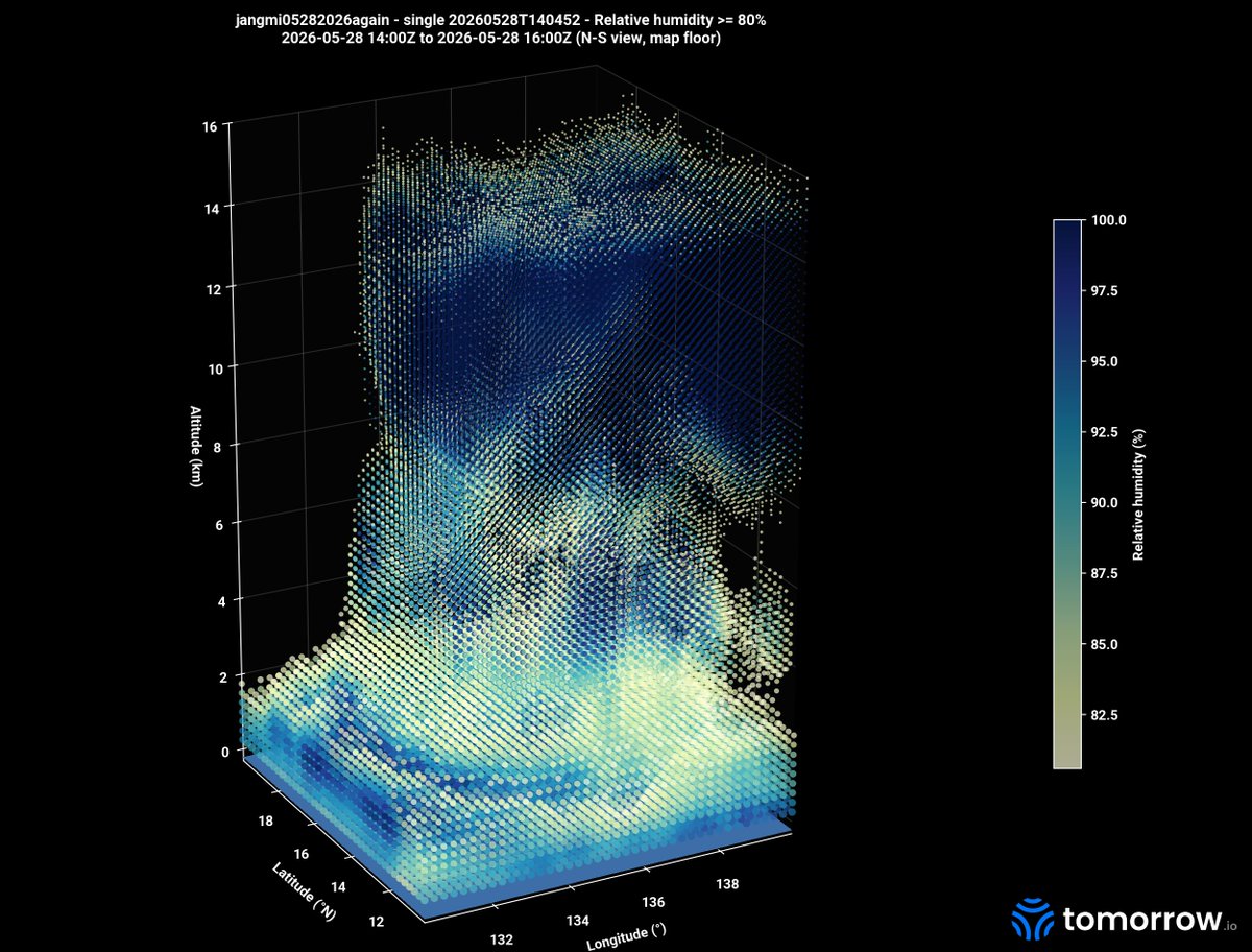
Jangmi has moved past Japan and is now transitioning into an extratropical system east of Honshu, but the impacts it brought are still being felt, including heavy rain, flooding and landslide risks, travel disruption, and power outages in affected areas.
We followed this storm from its early organization over the Philippine Sea, through its intensification and turn toward Japan, reading it through every layer of the atmosphere.
Storms like this are exactly why we watch the sky the way we do: not to marvel at them, but to see them coming sooner, so the people in their path have more time.
Below is a glimpse into the data we’re collecting in pursuit of better early warnings: a high-frequency, four-dimensional view of storms like Jangmi, from the top of the atmosphere down to the surface.
2
5
323
Jun 1
Bringing the invisible atmosphere into color.
Something new is on the radar. Get ready for a different kind of drop.
2
5
418
May 29
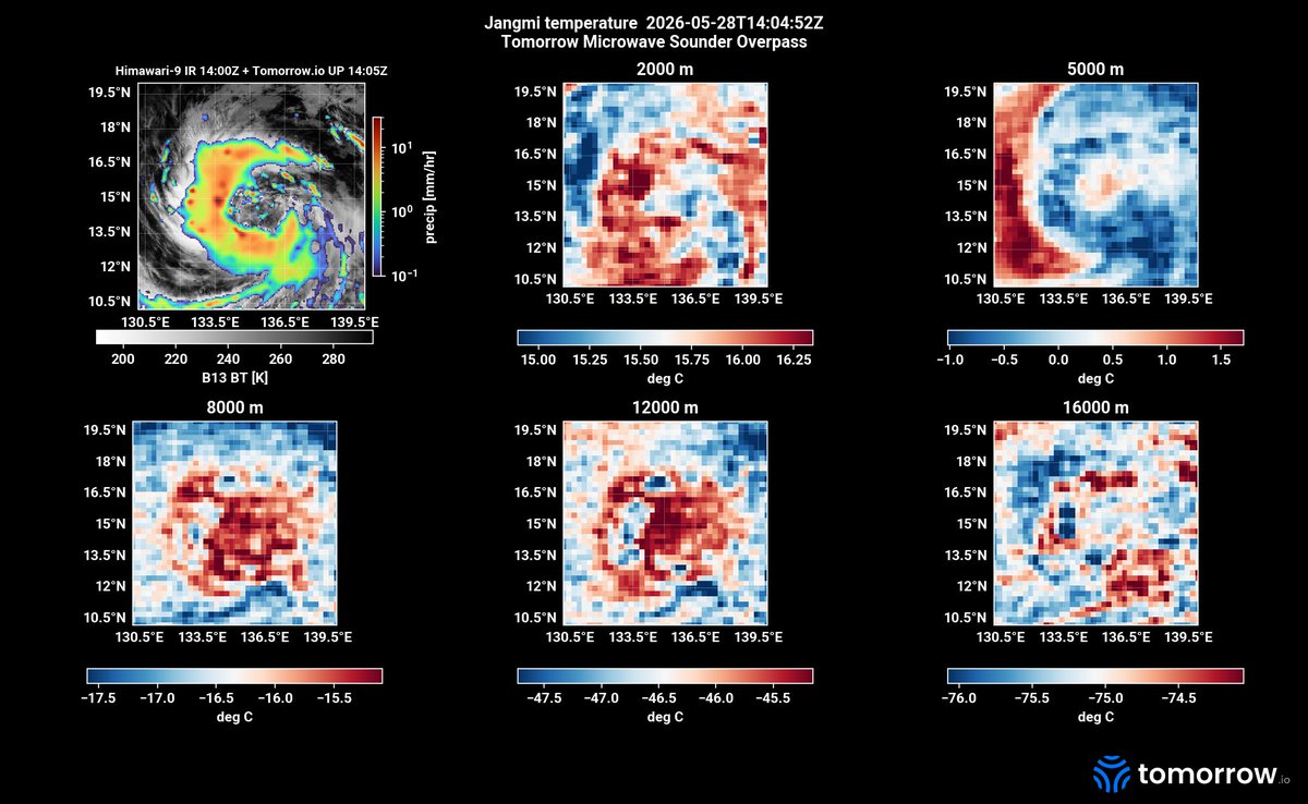
Meet Tropical Storm Jangmi (locally: Domeng).
Organizing from a depression into a named storm over the Philippine Sea, east of the Philippines, captured in a full 3D volumetric scan from the Tomorrow.io constellation at 1404Z on 28 May 2026 with two additional scans from the Tomorrow Constellation produced within the next 65 min at 1409Z and 1509Z.
Traditional high-frequency satellites give us a flat picture from above. Our sounders give us the vertical structure, moisture columns, cyclonic deep convection that could later organize into an eyewall, the early signals of strengthening, at a first-of-its-kind cadence.
And the stakes are not abstract. Directly downstream are the Filipino farmers we already serve, part of a global network of growers using Tomorrow.io data to protect harvests and manage risk where weather intelligence has historically been hardest to come by. Better observation means better odds for the people whose livelihoods depend on what storms like this do next. Scale that worldwide and you're not just forecasting storms, you're catalyzing global agricultural yield.
We'll keep watching. Every overpass is another slice of a global dataset built for one goal: detecting the causality behind rapid intensification, anywhere on Earth, before it unfolds.
The atmosphere is three-dimensional and evolves in real-time. Finally, our global observations are too.
2
7
310
May 29
We’ve launched software.
We’ve launched satellites.
Next, we launch ______.
Wrong answers welcome.
Coming soon.
1
4
222
May 21
This is severe weather, seen from space:
Hours before storms hit the Gulf Coast yesterday, @tomorrowio_'s satellite constellation was already tracking the atmospheric conditions driving them.
The visualization attached shows warm, moisture-rich air near the surface sitting beneath colder, unstable air aloft: the ingredients for severe storms already in place long before they formed.
With global atmospheric revisit rates every 60 minutes, our constellation continuously feeds the AI models powering our Resilience Platform™ in real time.
This is a perspective only Tomorrow.io can deliver.
Follow along for more soon 🛰️
1
8
469
Tomorrow.io retweeted

Tech News of the Week:
(This is for informational purposes only, and in no particular order)
1) Mouro Capital @mourocapital: Mouro Capital Secures $400 Million First Close for Latest Fund.
Source: tech.eu/2026/05/19/mou…
2) SiMa.ai @SiMa_Inc: Edge Inference Chip Startup SiMa.ai Raising at $1.4 Billion Valuation.
Source: theinformation.com/newslette……
3) Calibre: Ex-Palantir Duo Raises $3.3 Million to Deploy AI Agents Across the Certification Industry.
Source: techfundingnews.com/ex-palan……
4) Cosmico: Talent Startup Cosmico Raises €12 Million and Acquires Flatmates to Replace Broken Freelance Marketplaces with AI Matching.
Source: techfundingnews.com/cosmico-……
5) Tomorrow.io @tomorrowio_: Tomorrow.io Adds $35 Million to DeepSky Funding Round.
Source: spacenews.com/tomorrow-io-ad…
6) Xpanner: This Startup Just Raised $18 Million to Rewire America’s $700B Construction Crisis.
Source: techfundingnews.com/xpanner-……
7) Searchable: Headline Backs Searchable’s £10.3 Million Raise at £62.9 Million Valuation to Help Brands Win in AI Search.
Source: techfundingnews.com/searchab……
8) Exhibitly: Ghent-Based Exhibitly Raises €1.4 Million to Bring AI Personalisation to B2B Events.
Source: eu-startups.com/2026/05/ghen……
9) Stainless: Stainless is Joining Anthropic.
Source: stainless.com/blog/stainless…
10) CRACI: CRACI has Raised 1.4M€ to Bring Continuous Compliance to Software Supply Chains.
Source: craci.com/news/pre-seed-…
1
2
256
Tomorrow.io retweeted

May 19
Tomorrow.io Extends Series F Funding
@tomorrowio_ raised an extra $35M, pushing its Series F to $210M. The funds will expand its weather #satellite #constellation to improve real-time planetary data tracking.
🔗 spacewatch.global/2026/05/to…
#SpaceWatchNews #SpaceEconomy

1
3
270
May 19
When a satellite loses communications, most teams start writing the obituary.
Sam Gagnard and the Tomorrow.io Space & Sensors team didn't.
In our latest Expert Forecast episode, Sam explains what kept the team pushing when comms with their payload went dark: the radiometer itself was still functional. The problem was isolated. That meant recovery was still possible, even if only partial.
But the bigger driver was the constellation. Every lesson learned from one satellite applies to all the others. Even if you can't fully recover a payload, understanding what went wrong is its own kind of win.
That's how you build space weather infrastructure that lasts.
Watch the full episode to hear Sam break it down: okt.to/Br1iON
2
263
Tomorrow.io retweeted

May 18
Weather intelligence unicorn @tomorrowio_ expands Series F to $210 million with $35 million in new funding.
New capital to accelerate DeepSky satellite constellation and agentic AI development.
calcalistech.com/ctechnews/a…
1
4
305
May 18
Today, we're expanding our Series F with an additional $35M investment from @Pitango and their partner @HarelInsurance bringing the round to $210M.
This reflects continued conviction in Tomorrow.io as the #1 AI-native Resilience Platform™ that businesses, governments, and communities rely on to operate in an increasingly volatile world.
The capital will support continued investment across the full platform, including software, AI models, and our next-generation satellite infrastructure.
Thank you to @Pitango and @HarelInsurance for the continued partnership and to our customers and team for making this work possible!
3
6
291
May 12
What makes Tomorrow.io different as a place to do weather science? Max Green, one of our data scientists, puts it simply.
The data. We operate our own satellite constellation that measures how temperature and humidity actually vary through the atmosphere. That's not something most forecast teams have access to.
The pace. If a new strategy is emerging in academic or industry research, we're testing it fast. If it doesn't work, we move on. No months-long approval cycles.
For scientists used to slower-moving institutions, that combination changes what's possible.
2
307
May 5
Most people picture weather satellites as cameras in the sky. The Tomorrow.io sounder satellites work differently.
They use passive microwave radiometers to pick up natural emissions from the atmosphere across a range of frequencies. From those signals, scientists can reconstruct vertical profiles of temperature and moisture, essentially a cross-section of the atmosphere at any given location.
That's the data weather models have always needed more of. A constellation of satellites in low Earth orbit, each with a wide collection swath, delivers global coverage frequently enough to actually improve forecast accuracy.
Better predictions start with better data.
This is what closing that gap looks like.
If you want to hear more from our space team about the constellation and how we recovered from the S1 satellite loss, watch the full episode with Sam Gagnard here: okt.to/fEOeMK
2
3
394
Apr 29
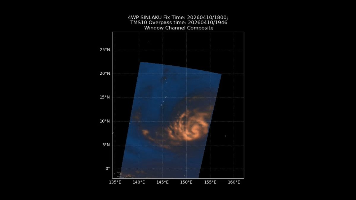
Earlier this month, Super Typhoon Sinlaku formed, rapidly intensified to a Category 5, and made landfall on the Northern Mariana Islands, all within about a week.
Tomorrow.io's TMS constellation captured the full storm life cycle as it approached Guam.
This is what our satellite constellation captures, enabling consistent tracking of a storm from formation to landfall, including the moments of rapid intensification that matter most for early warning.
More revisits mean earlier signals when a storm is strengthening. More clarity on where impact is heading. More opportunity to act before it's too late.
That could mean rerouting flights, adjusting operations ahead of landfall, or avoiding unnecessary shutdowns when the risk doesn't materialize.
Better data changes outcomes.
1
2
7
289
Apr 28
We heard a couple of weather apps are down today... 👀🙈
If you still need a weather update, consider the Tomorrow.io weather app, available on the App Store: apps.apple.com/us/app/tomorr…
3
270
Apr 28
Everyone is talking about agentic AI. 🤖
Most platforms still give you a static map and a forecast.
Our Spring release is what agentic actually looks like in operations.
Weather intelligence that lives on the asset, in the cockpit, inside the agent, and across the alerts your teams already depend on.
What's new in this release:
Asset Insight Dashboard: Monitor flights, routes, vessels, and insured portfolios with the operational context your business actually runs on. The pin on the map just became a living asset.
3D Map and Pilot View. Render volumetric clouds, storm tops, AIRMETs, and SIGMETs at the altitudes they actually occur. For the first time, dispatch and the cockpit can share the same view of the sky.
Tomorrow.io MCP Server. Your agents and pilots can now pull our intelligence as a first-class input. No custom wrappers. No brittle glue code.
Smarter alerting at scale. Grouped alerts and location subscriptions take the noise and the admin overhead out of running alerting across many locations and teams.
This is what we mean by "agentic". Not a chatbot bolted onto a forecast. Real intelligence, in the moment, where the decision actually gets made.
Here's a sneakpeek of our MCP update.
Read the full release rundown 👉
okt.to/umIaZc
3
256