

Exactly, it is math! You say the straight line on the graph is just a math convenience. But the geoid is also just math—a theoretical gravity model. Why do you accept the globe math as physical reality, but dismiss the flat engineering math as a mere drawing? Go out and measure!!
2
1
6
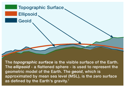
A geoid maps the hypothetical shape of the ocean assuming a gravitational sphere.
Defining the datum with a geoid is just injecting the globe assumption into the starting measurement.
Can you measure the physical curvature of the lakes without using globe-based math? Course not.
1
4
You admit they draw the physical water as a straight, parallel line because it is "an easy reference point."
It's easy because water natively settles flat.
Why do you assume the flat engineering graph is just a trick, but the invisible spherical "geoid" model is reality?
2
3

You don't know that the International Great Lakes Datum (IGLD) is a dynamic height based on the globe?
It's the third line in the wikipedia entry... maybe do the bare minimum amount of research!
"It is based on dynamic heights with respect to the geoid."
1
12

Bunun sebebi geoid olan dünyayı 2 boyutlu ve anlaşılabilir şekilde “merkator projeksiyonu” usulüyle kağıda yansıtmalarından. Mesela İngiltere’den Atlas’ı aşıp Brezilya’ya seyir yapmak Cebelitarıktan çıkıp Afrika’nın en güneyine inmekten de daha kısa sürer gün bazında.
1
584

Bu 2 boyutlu harita ama dünya 3 boyutlu geoid. 3 boyutlu bir şeyi 2 boyutta gösterirken bozulma olur. 9. sınıfta hepiniz gördünüz bunu ama nedense her insan lise sonrası beynine reset atıyor herhalde. Ekvator çevresindeki her ülke kağıt üstünde gerçekte olduğundan küçük görünür
3
1,961

Jun 14
For over 42 years, she worked on complex calculations for satellite geodesy (measuring Earth's shape and gravity). Key highlights:She helped create precise mathematical models of Earth's irregular shape (called the geoid), accounting for gravity, tides, and other forces.
As project manager for Seasat (the first ocean-observing satellite) and related GEOSAT work, she programmed computers to process radar altimetry data and calculate accurate satellite orbits.
These models became foundational to the Global Positioning System (GPS)—without her team's precision, modern GPS wouldn't be nearly as accurate for navigation, phones, cars, aviation, and more.
en.wikipedia.org
3

He doesn’t know what trim is. Doesn’t know how many types of altitude there are. Doesn’t know MSL is a geoid. Etc etc
1
18

Jun 13
Geoid yumurta şekli . Dumduzle hiçbir alakası yok o kelimenin ingilizce çevirilerde bile yumurta olarak çevrilmiş.
70


Why is this a parabola?
For L=29.2mi, arc height = 142.14ft.
142.54ft / 2 = 71.07ft per side.
And, importantly: the elevation profile is relative to a datum, not to a flat plane - i.e. the geoid or ellipsoid.

1
15


Jun 13
ブロンズ目指すため、自宅トレーニング環境を整えた。geoid ve200という格安スマトレをアリエクで25000円で購入。zwiftとの連携も問題なくできてます。
で、初ftpランプテストの結果は、224w。体重75kgなのでちょうど3倍。富士ヒルのタイム1h37minとも合ってますね。

102


Rocio💗 retweeted

Jun 12
Fuck off, 4th blue Turtle/Land if rich/fertile middle, USAian-flatlander [Alt 227] r squared...!$^
Geoid cube covered, [inside/sub-set] Gaia's 5D blanket that 'is' all LIFE
One God a 'if'
2D hands Gaia my 1 of 11 4th God of a dozen, our Milkyway 4 spiral arm galaxy, Finite.
#Aus
Jun 12

I wouldn’t be where I am today without the love and support that @MichelleObama has poured into me over the years. Her story — from her South Side roots to the White House and beyond — is a central part of the Obama Presidential Center.
1
1
118

Jun 12
The Theoretical Purpose
1) A Planetary Stabilization Beacon: The Earth’s crust experiences continuous localized stress. By acting as a literal seismic heat-sink, the Giza complex could have absorbed chaotic tectonic strain and re-radiated it safely into the upper atmosphere as acoustic or electromagnetic energy. In this sense, it was an engineering marvel built to stabilize the local geoid, mitigating catastrophic earthquakes and preserving the structural integrity of the delta region over millennia.
2) Global Navigation and Telecommunications: To map a planet accurately, you need an absolute reference point that accounts for axial precession and orbital wobbles.
Because the pyramids are anchored to the bedrock and tuned to the Earth's core frequencies, the electromagnetic emissions from the pyramid apexes would create a highly localized, ultra-stable ionospheric disturbance.
This would act as a planetary "GPS" beacon. Any advanced vehicle or survey equipment capable of reading low-frequency radio or acoustic vectors could synchronize its position globally relative to the Giza zero-meridian.
3) Wireless Energy Grid (The World System): By exciting the cavity between the Earth's surface and the ionosphere (the cavity that houses Schumann resonances), the combined subterranean-superterranean structure may have acted as a wireless transmitter. The pyramids would shoot ionized, high-frequency electrical columns into the atmosphere, allowing energy to be tapped wirelessly anywhere across the globe by utilizing matching resonant receivers (much like Tesla’s experiments).
49