
GeoLibre v1.3.0 is here!
GeoLibre is a free and open-source, lightweight, cloud-native GIS platform for visualizing, exploring, and analyzing geospatial data. One application that runs everywhere: in your web browser, as a native desktop app, on your phone, and inside a Jupyter notebook. No account, no server, no cost. Everything runs locally and your data stays private.
This release packs in 50 pull requests of new capabilities. A few highlights:
- GIS in your pocket. A native Android build with offline tile caching and download-a-region support, so you can take your maps into the field with no signal.
- AI, built in. A natural-language GIS assistant that turns plain-English requests into real geoprocessing, plus an AI segmentation toolbox powered by SamGeo and SAM 3 for extracting features from imagery.
- Automate everything with Python. A full scripting API and an in-app Python Console, with new helpers for local rasters, choropleths, marker clusters, split-map comparisons, legends, and colorbars.
- Map together, live. Real-time multi-user collaboration so you can open a project and edit the map with others at the same time.
- Tell stories with maps. A scroll-driven story map builder and presenter that exports interactive narrative maps to standalone HTML.
- A much bigger analysis toolbox. Reproject, explode, and aggregate tools, IDW and kriging interpolation, zonal statistics, a raster calculator, a Spatial Statistics toolbox, and network analysis with isochrones, service areas, and OD cost matrices, plus batch runs and model/pipeline chaining.
- Smarter raster and SQL. Single-band pseudocolor classification, RGB band combinations, a no-backend client-side raster fallback, Apache Sedona as a SQL Workspace engine, and transparent S3, GCS, and Azure URL support in queries.
- More ways to add, view, and share. New Shapefile and GeoPackage export, glTF/GLB 3D model layers, multi-provider batch and reverse geocoding, collapsible layer groups, and a macOS Homebrew cask.
Try the live demo: viewer.geolibre.app
Star it on GitHub: github.com/opengeos/GeoLibre
Docs and roadmap: geolibre.app
Release notes: github.com/opengeos/GeoLibre…
#GIS #OpenSource #Geospatial #MapLibre #WebGIS #Android #GeoLibre
6
41
196
9,259

Jun 14
You can't reproject the projection you already projected.
1
4

you could convert the grease pencil objects to mesh and reproject textures then make the world in normal VR, no need for splatting
1
1
19

Jun 11
Zaxy's graph stays clean through a layered set of mechanisms, and the most important one is architectural rather than janitorial:
1. The graph is a disposable projection, not the store. Eventloom (the append-only, hash-chained log) is the source of truth; the embedded Kuzu graph is a deterministic projection of it. That means the graph can always be discarded and rebuilt by replay (zaxy reproject). Cruft, drift, or schema evolution never require surgery on the graph. You rebuild it from the log with current extraction logic. Cleanliness is reproducible rather than maintained by hand.
2. Temporal validity instead of mutation. Entities carry valid_from/valid_to windows. When a fact is superseded or invalidated (memory_invalidate), the old version's validity window is closed. Nothing is deleted, but default queries read only active (current-state) entities, so superseded versions don't clutter retrieval. History stays available for temporal/as-of queries without polluting the present.
3. Extraction policy gates what becomes a node at all. Deterministic extractors decide which event kinds project into entities. Bookkeeping events, hook lifecycle markers, the new memory.reinforcement salience events, FoK calibration markers, have deliberately empty extractors registered, so servability traffic never creates graph entities or perturbs
BM25/verbatim statistics.
4. Review-gated consolidation compacts episodic sprawl. The consolidation pipeline turns runs of fine-grained events into cited, review-pending candidates (episodes, claims, procedures). Only accepted candidates become compact abstractions, and the originals remain in the log rather than the working graph's hot path. The geometry-aware consolidation work adds safety auditing around this (identity invariants, compaction risk checks).
5. Projection-level forgetting (new this release). The salience ledger attenuates memories that decay below a floor. They leave default checkout ranking (while staying reachable by explicit query and fully storable, since salience is replayed from the log). The opt-in encoding gate classifies appends as novel/reinforcing/redundant, so duplicates project as
reinforcement signals on existing entities rather than accumulating as new ranked content.
6. Bounded derived state. The performance-sensitive structures over the graph — vector index caches (LRU 256 MiB byte budget), adjacency snapshots, traversal indexes — are signature-invalidated and budget-evicted, and embeddings are version-tagged with a batch re-embed migration path, so stale derived state can't silently accumulate or mix incompatible versions.
The raw event log itself only grows — that's by design (it's the audit record). "Clean" in Zaxy means the queryable surfaces stay current, compact, and uncontaminated, while the full history remains intact underneath.
68
Raw AI generated assets from all the generators we have tried are horrible. Thousands of tiny UV islands. Doesn't LOD well at all. We remesh AI source assets to improve the topology. Then we reproject the high mesh geometric details on medium poly asset and bake new normal maps. This has ~10x less UV islands so it LODs much better and the starting point has 10x less triangles, but looks almost identical as all fine details are preserved in the normal map. This pipeline is fully automated. @JarkkoPFC posted some examples.
1
20
3,136

Jun 6
Fun weekend project: using @AIatMeta Sam3 to segment objects inside a @SpAItial_AI scene.
Pipeline:
-> Generate a world on @SpAItial_AI app and export as .ply
-> @playcanvas viewer to render splat a uniform spatial grid over splat centers
-> Capture frames camera pose, POST to a local SAM3 server
-> Lift each 2D mask → 3D: frustum-cull splats via the grid, reproject with the pose
-> Recolor / isolate the segmented Gaussians
This is all running locally on my Mac. Static scene, segment once, reuse persisted mask.
All open source (link in comment), you can clone and build on top of this 👇🏽
10
40
366
21,035

i enjoy spending times gorging myself on foreign (to me) belief systems for lots of reasons. the primary one is probably just an addiction to lore. but a lesser delicacy:
being able to see how badly people misinterpret and reproject Not Theirs is always eye opening
1
4
201


May 31
I just did show reference footage: the official Gorgon Stare video.
And the funny part is your own image helps my argument. It shows exactly the kind of multi-frame cloud mosaic problem I’m talking about: separate camera/image captures, overlapping rectangles, repeated cloud regions, edge fills, and stitched visual territory being turned into one larger image.
That is the entire point.
You’re framing it like, “why would someone add a cloud from a mile away?” But in a WAMI/mosaic/reprojection workflow, nobody is manually “adding a cloud” like Photoshop. The system is assembling a wide-area view from multiple captures. If the image tiles overlap, shift, stabilize, fill, or reproject incorrectly, you can absolutely get clouds appearing in places that look wrong when judged as if it were one normal camera shot.
So again, the burden is not “can you find similar cloud patches?” The burden is proving those exact public assets existed first and were used to fabricate the MH370 video.
Because right now your argument is basically:
WAMI footage shows stitching/mosaic behavior.
The MH370 video shows imagery that can be interpreted as stitched/mosaic behavior.
Therefore it must be fake.
No. Bullshit.
Also, the official Gorgon Stare video literally references MQ-9 Reaper deployment, and the thermal MH370 video appears to show MQ-9-style framing/airframe obstruction on the left side. So now the hoaxer supposedly guessed the drone platform, the surveillance style, the satellite-style view, the dual-perspective geometry, the cloud field, the orb tracking, the thermal behavior, and the military ISR aesthetic?
That’s not impossible (even though it kinda is), but it is a much bigger claim than “I matched some clouds.” Come on man, it really shouldn't be this hard. It's okay to be wrong, I promise.
1
1
2
161

May 20
Also: another caveat: the "already enough lag from streaming" is partly true, partly not true. Typically when you decode frames rendered remotely, on a PC in the cloud or over Wifi, you decode them knowing their original render pose, so that local compositor can reproject them.
1
2
101

May 19
Modern car 360 degree parking cameras cache the surroundings and reproject them. Remembers the road/markings even under your car. We test drove the new Mercedes GLC (AMG trim) last month and it had similar parking cameras. And rear-axle steering. Was super nice to park.
May 18

For those who tell me this is not useful watch the video below!
XPENG did a mind blowing job 🔥🔥🔥
One of the best features. And YES my car can park itself too ⬇️
1
1
37
7,709

May 13
Nah it's about real VR games. The compositor typically spits out frames with the native refresh rate of the headset. If the game engine does not deliver frames that fast it will "reproject" the previous frame to match your movement in physical space. Otherwise you would get really motion sick.
To improve that reprojection a game can tell the compositor how far away different parts of the image are. So the compositor can "warp" them correctly when you move left to right (objects closer to you move more than farther away).
If the game does not send that depth data the compositor has to guess, so valve is asking game devs to supply that depth data.
5
104

Apr 30
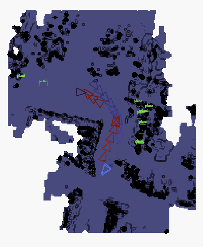
5/ Reproject your processed memories on the Global Map:
Take the strongest matches from semantic search and reconstruct the local 3D environment around each detection. You can see the places a plant was detected.
1
1
11
719


Apr 15
How to train without multi-view data? We turn single images into training pairs.
A frozen depth estimator lifts the image to 3D. We sample a camera pose and reproject to obtain a sparse pseudo-target.
At inference, the depth model is discarded: 1 image 1 pose, 1 forward pass.
1
21
1,888

Apr 12
I built this sweet visualizer for shadow map texels in Use.GPU, which is great for testing.
It's also highly annoying, because it reveals all the subtle errors and how all use of shadow maps in rendering is really three raccoons in a trench coat.
Video: for point lights and wide spot lights, I reproject a cube map to octahedral, to make it easier to blur and sample in an atlas.
Using nearest-sampling for depth however introduces significant moiré patterns which require a huge depth bias to fix.
1
4
14
1,006


Outsmart Perspective Changes
Discover why you should use Silhouette's Unproject/Reproject workflow inside Flame to tackle tiny paint details — like odd angles — that draw attention away.
hubs.ly/Q04b9mnX0
1
2
428
