
Official account of #AnnArbor Police Dept. Follow for information about the City and the Department. For emergencies, contact 911. linktr.ee/a2police
- Tweets 2,211
- Following 208
- Followers 6,840
- Likes 314


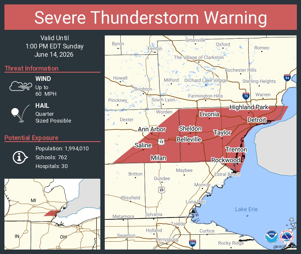
ALT This graphic displays a severe thunderstorm warning plotted on a map. The warning is in effect until 1:00 PM EDT. The warning includes Detroit MI, Ann Arbor MI and Dearborn MI. This warning is for Wayne County in southeastern Michigan and Southeastern Washtenaw County in southeastern Michigan. The threats associated with this warning are wind gusts up to 60 MPH and quarter sized hail. There are 1,994,010 people in the warning along with 762 schools and 30 hospitals.


ALT Michigan State Police Traffic Crash Banner


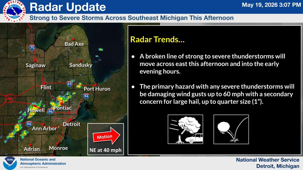
ALT A broken line of strong to severe thunderstorms will move across east this afternoon and into the early evening hours. The primary hazard with any severe thunderstorms will be damaging wind gusts up to 60 mph with a secondary concern for large hail, up to quarter size (1”).
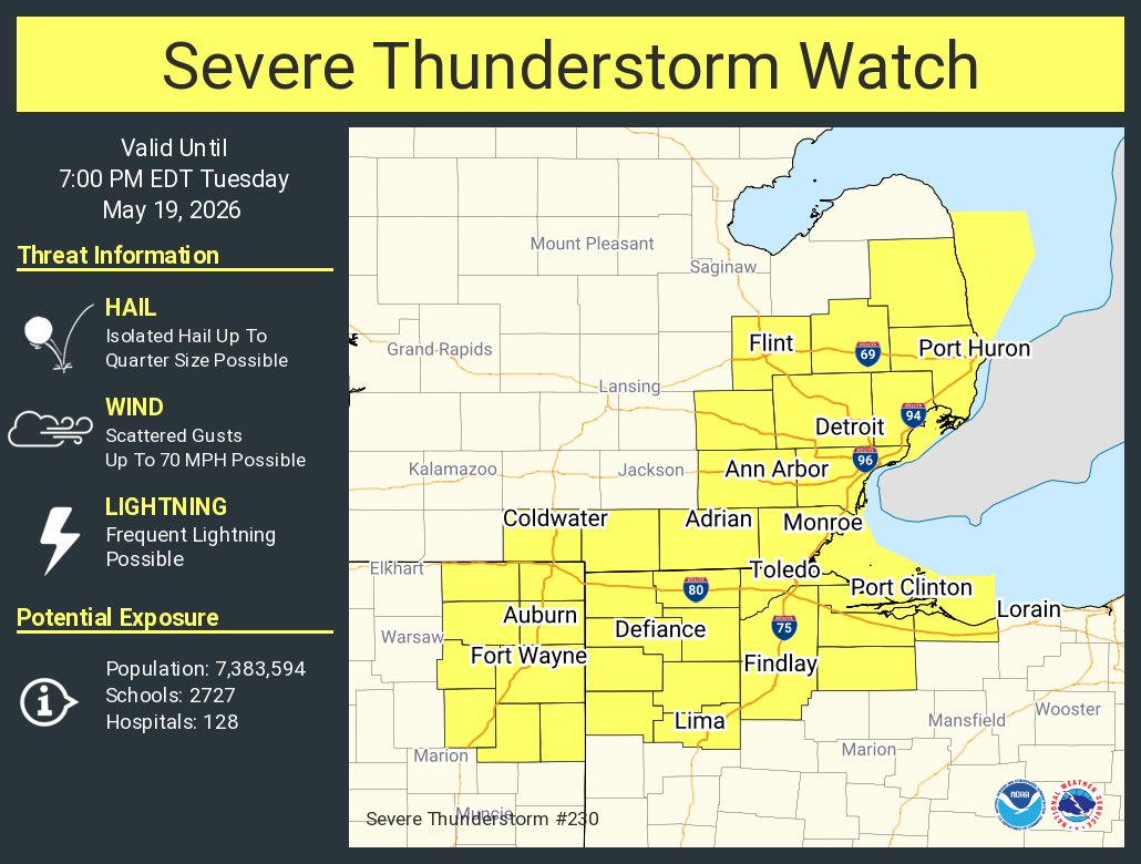
ALT This graphic displays Severe Thunderstorm watch number 230 plotted on a map. The watch is in effect until 7:00 PM EDT. The watch includes parts of Indiana, Michigan and Ohio. The threats associated with this watch are no tornadoes expected, isolated hail up to quarter size possible and scattered gusts up to 70 mph possible. There are 7,383,594 people in the watch along with 2727 schools and 128 hospitals.
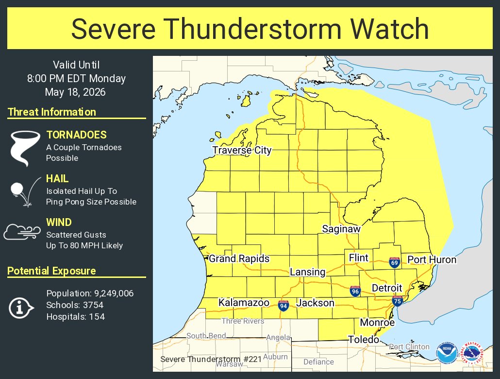
ALT This graphic displays Severe Thunderstorm watch number 221 plotted on a map. The watch is in effect until 8:00 PM EDT. The watch includes parts of Michigan. The threats associated with this watch are a couple tornadoes possible, isolated hail up to ping pong size possible and scattered gusts up to 80 mph likely. There are 9,249,006 people in the watch along with 3754 schools and 154 hospitals.
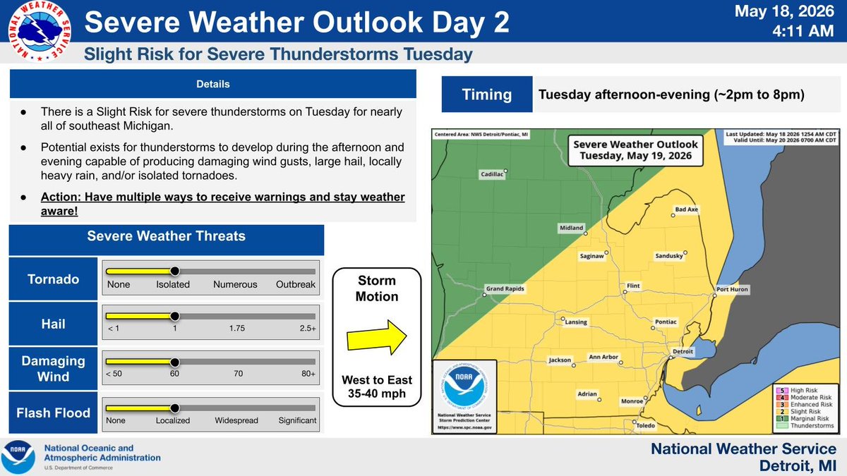
ALT The graphic shows Slight risk for all of southeast Michigan for Tuesday Timing: 2 PM - 8 PM. Severe thunderstorms will be capable of producing damaging wind gusts to 60 mph, large hail up to an inch, localized flooding, and/or isolated tornadoes. Action: Have multiple ways to receive warnings and stay weather aware!
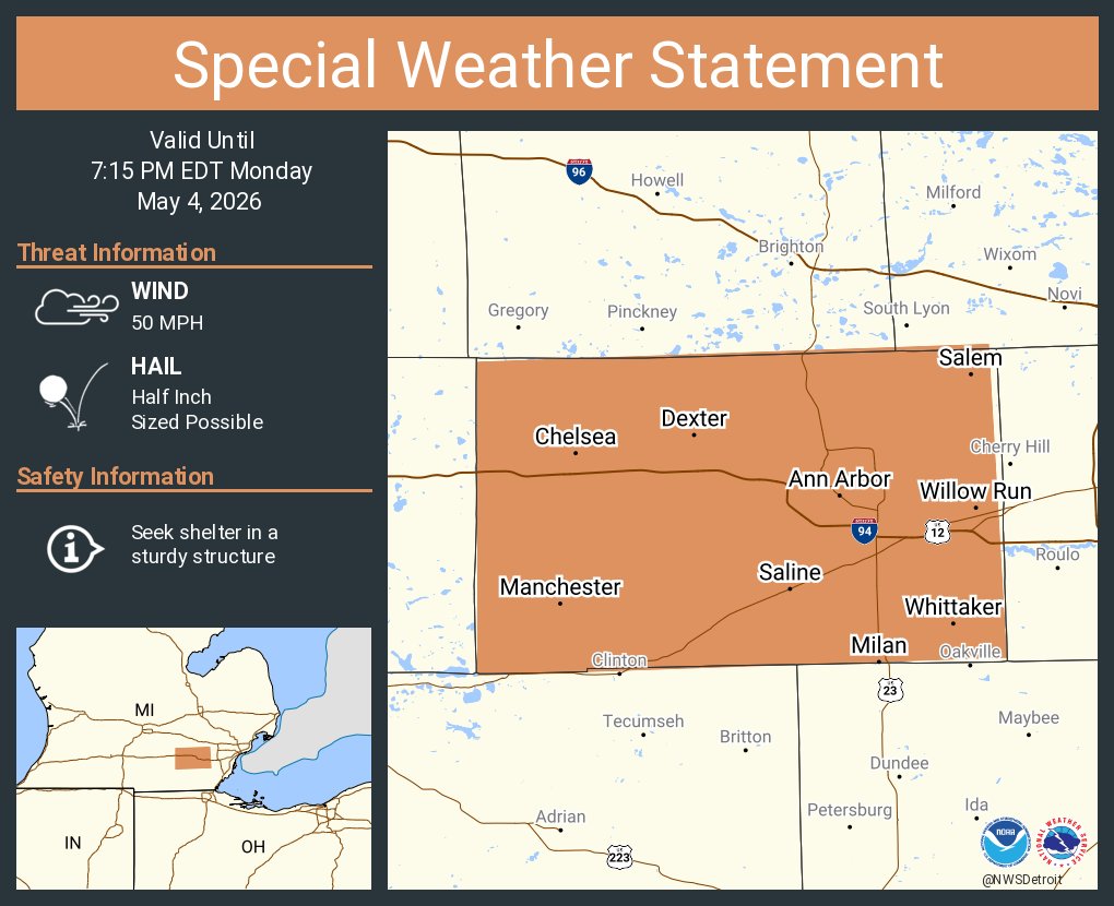
ALT This graphic displays a special weather statement plotted on a map. The statement is in effect until 7:15 PM EDT. The statement includes Ann Arbor MI, Ypsilanti MI and Saline MI. STRONG THUNDERSTORMS WILL IMPACT WASHTENAW COUNTY THROUGH 715 PM EDT. The threats associated with this storm are wind gusts up to 50 MPH and half inch sized hail. Seek shelter in a sturdy structure until the storm passes.

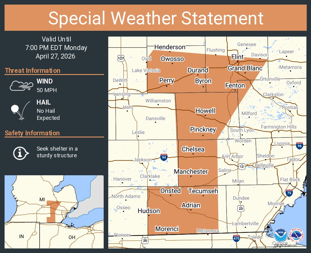
ALT This graphic displays a special weather statement plotted on a map. The statement is in effect until 7:00 PM EDT. The statement includes Flint MI, Burton MI and Adrian MI. SHOWERS WITH GUSTY WINDS WILL IMPACT LENAWEE, NORTHWESTERN OAKLAND, SHIAWASSEE, LIVINGSTON and SOUTHERN GENESEE AND WESTERN WASHTENAW COUNTIES THROUGH 700 PM EDT. The threats associated with this storm are wind gusts up to 50 MPH and no hail is expected. Seek shelter in a sturdy structure until the storm passes.
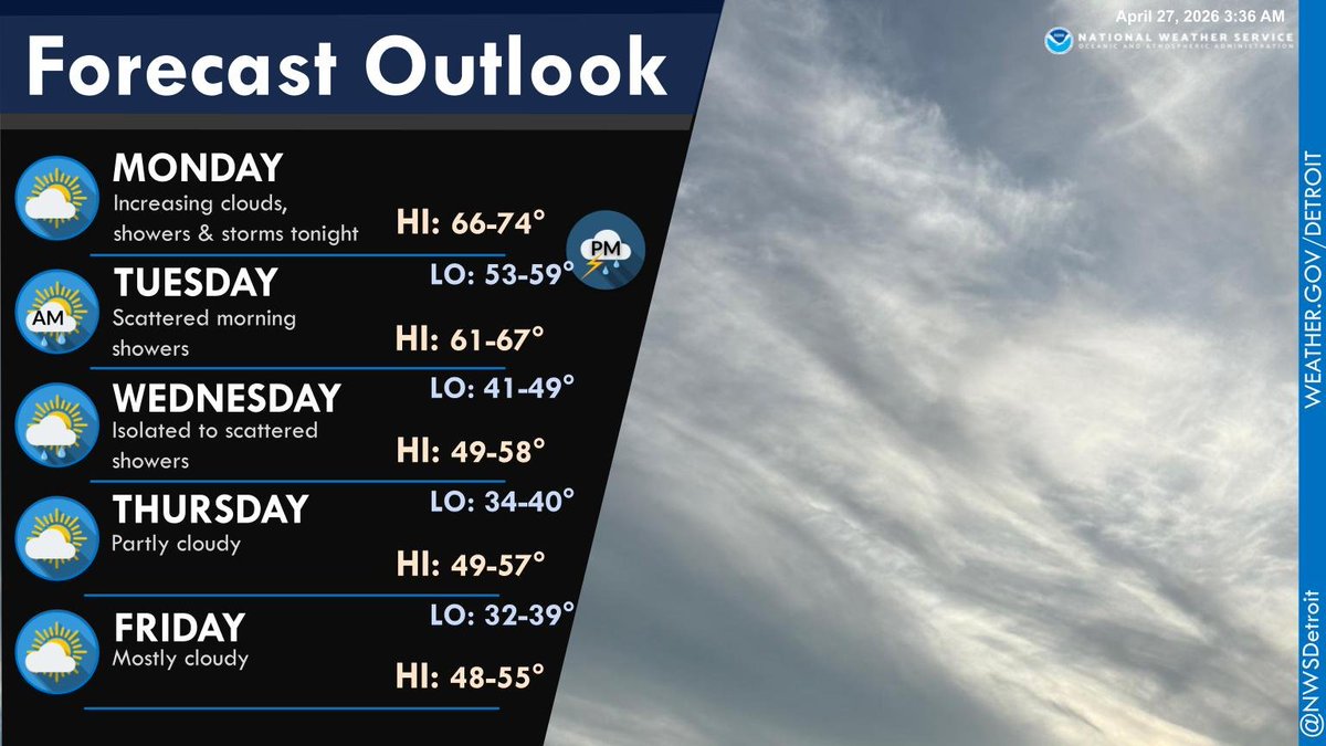
ALT Forecast Outlook Monday: Increasing clouds, then showers and storms tonight. Highs 66 to 74. Tuesday: Scattered morning showers with lows 53 to 59 and highs 61 to 67. Wednesday: Isolated to scattered showers with lows 41 to 49 and highs 49 to 58. Thursday: Partly cloudy with lows 34 to 40 and highs 49 to 57. Friday: Mostly cloudy with lows 32 to 39 and highs 48 to 55.