
Adam Moore is an Emergency Manager with a Bachelor's from Millersville University and is currently pursuing his Master's. He works as an SAU Analyst with VDEM.
Joined September 2015
- Tweets 25,510
- Following 632
- Followers 5,136
- Likes 5,192
8,222 Photos and videos


Pinned Tweet

10 Jun 2021
Was able to capture the Partial Solar Eclipse in Sumerduck, VA this morning. #SolarEclipse #solareclipse2021 #vawx @capitalweather @StormHour @hbwx @spann @wxbrad

12
116
725
Jun 14
A Severe Thunderstorm Warning has been issued for King George, VA, Stafford, VA. | Max Hail: 1.0 inches, Wind: 60 MPH | Torrential Rain: Occurring | Frequent Lightning: Occurring | Expires at 7:00 PM 6/14.
92
Jun 14
The NWS has issued a Severe Thunderstorm Warning for Stafford County in VA until 7:00pm. bit.ly/3roNNv2 #VAWX
93
Jun 14
A Severe Thunderstorm Warning has been issued for Caroline, VA, Essex, VA, Westmoreland, VA. | Max Hail: 1.0 inches, Wind: 60 MPH | Expires at 7:15 PM 6/14.
77
Jun 14
Mesoscale Discussion has been issued for Parts of the Mid Atlantic. Expires at N/A.
124
Jun 14
A Special Weather Statement has been issued for Fluvanna, Cumberland, Goochland, Powhatan, Eastern Louisa until 7:15 PM 6/14 | Hail: 0.0 inches | Wind: 50 MPH
70
Jun 14
A Severe Thunderstorm Warning has been issued for Spotsylvania, VA, Stafford, VA, City of Fredericksburg, VA. | Max Hail: 1.0 inches, Wind: 60 MPH | Torrential Rain: Occurring | Expires at 7:00 PM 6/14.
76
Jun 14
The NWS has issued a Severe Thunderstorm Warning for Spotsylvania and Stafford County in VA until 7:00pm. bit.ly/3roNNv2 #VAWX
77
Jun 14
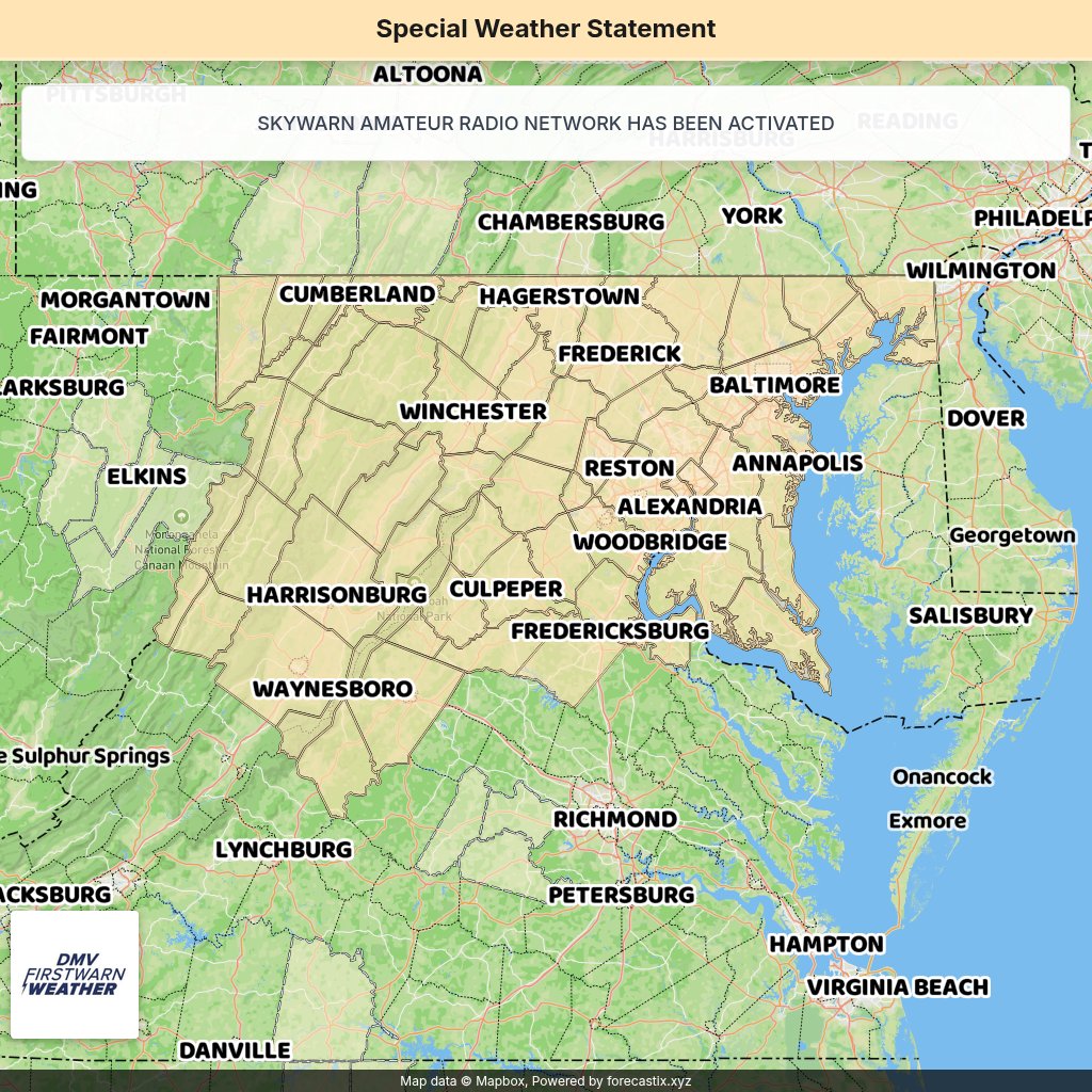
A Special Weather Statement has been issued for Goochland, Eastern Louisa, Western Hanover | Frequent Lightning: Occurring | until 6:00 PM 6/14 | Hail: 0.25 inches | Wind: 40 MPH
56
Jun 14
A Severe Thunderstorm Warning has been issued for Frederick, VA, Berkeley, WV, Hampshire, WV, Morgan, WV. | Max Hail: 0.75 inches, Wind: 60 MPH | Torrential Rain: Occurring | Expires at 6:15 PM 6/14.
1
90
Jun 14
The NWS has issued a Severe Thunderstorm Warning for Frederick County in VA until 6:15pm. bit.ly/3roNNv2 #VAWX
101
Jun 14
Special Weather Statement has been issued for Chesapeake Bay north of Pooles Island MD, Chesapeake Bay from Pooles Island to Sandy Point MD, Chesapeake Bay from Sandy Point to North Beach MD 69 more. Expires at N/A.
123
Jun 14
Severe Thunderstorm Watch has been issued for District Of Columbia, DC, Allegany, MD, Anne Arundel, MD 102 more. Expires at 06/14/2026 11:00 PM.
1
98
Jun 14
The NWS has issued a Severe Thunderstorm Watch for Clarke, Culpeper, Fairfax, Fauquier, Frederick, Loudoun, Louisa, Madison, Orange, Page, Prince William, Rappahannock, Shenandoah, Spotsylvania, Stafford and Warren County in VA until 11:00pm. bit.ly/3roNNv2 #VAWX
131
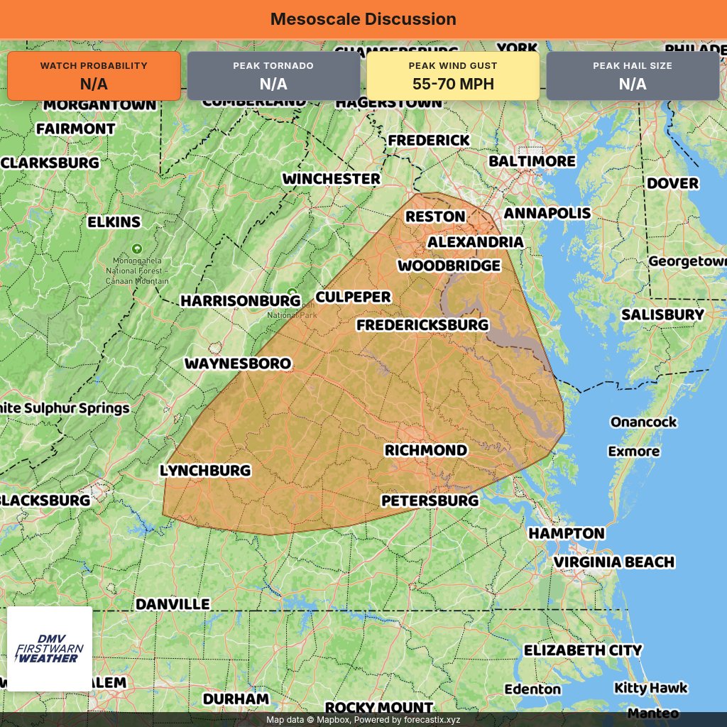
Jun 14
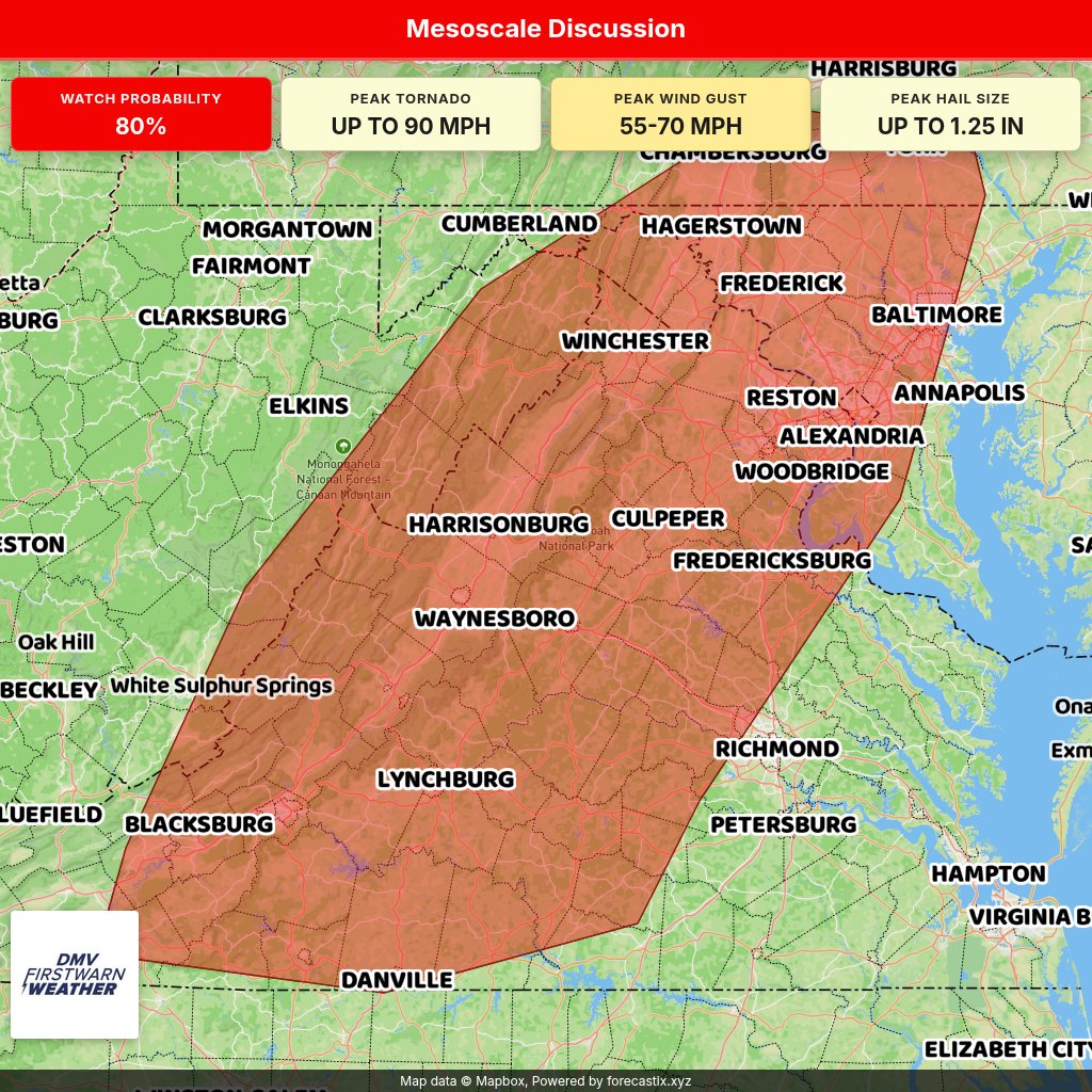
Mesoscale Discussion has been issued for portions of Virginia...far southern Pennsylvania...eastern Maryland. Expires at N/A.
1
215
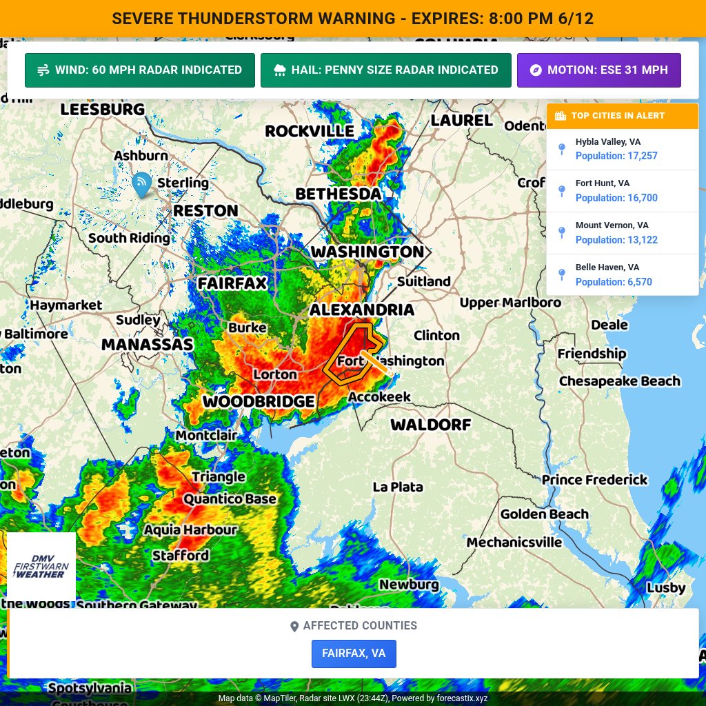
Jun 12
A Severe Thunderstorm Warning has been issued for Fairfax, VA. | Max Hail: 0.75 inches, Wind: 60 MPH | Expires at 8:00 PM 6/12.
95
Jun 12
The NWS has issued a Severe Thunderstorm Warning for Fairfax County in VA until 8:00pm. bit.ly/3roNNv2 #VAWX
129
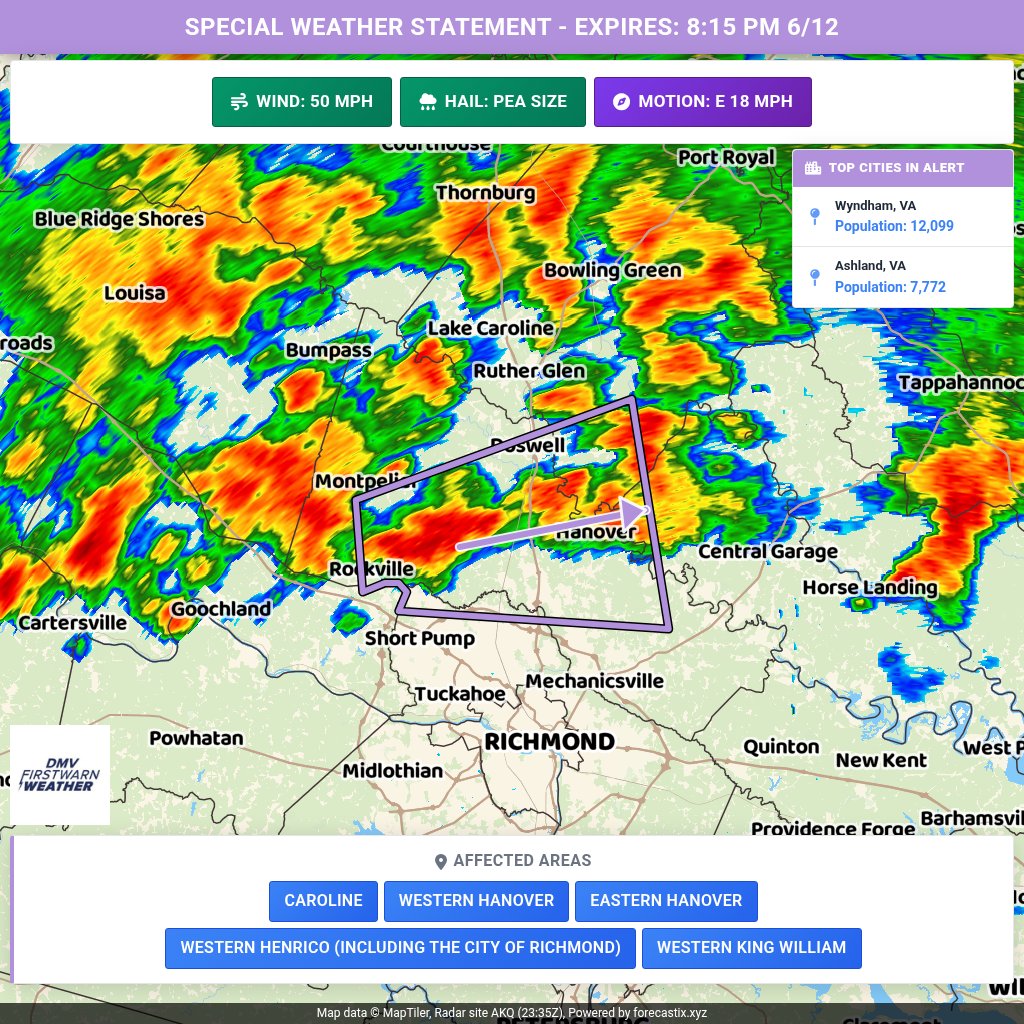
Jun 12
A Special Weather Statement has been issued for Caroline, Western Hanover, Eastern Hanover, Western Henrico (Including the City of Richmond), Western King William until 8:15 PM 6/12 | Hail: 0.0 inches | Wind: 50 MPH
92
Jun 12
The NWS has issued a Severe Thunderstorm Watch for Culpeper, Fairfax, Fauquier, Loudoun, Louisa, Madison, Orange, Prince William, Rappahannock, Spotsylvania and Stafford County in VA until 11:00pm. bit.ly/3roNNv2 #VAWX
137