A Flood Watch is in effect for South-Central Texas from 7PM this evening thru 7PM Tuesday. Heavy rain is forecast with isolated pockets of more than 8 inches, which may fall quickly and could cause life-threatening flooding. Stay weather aware! Turn around, don't drown! #txwx
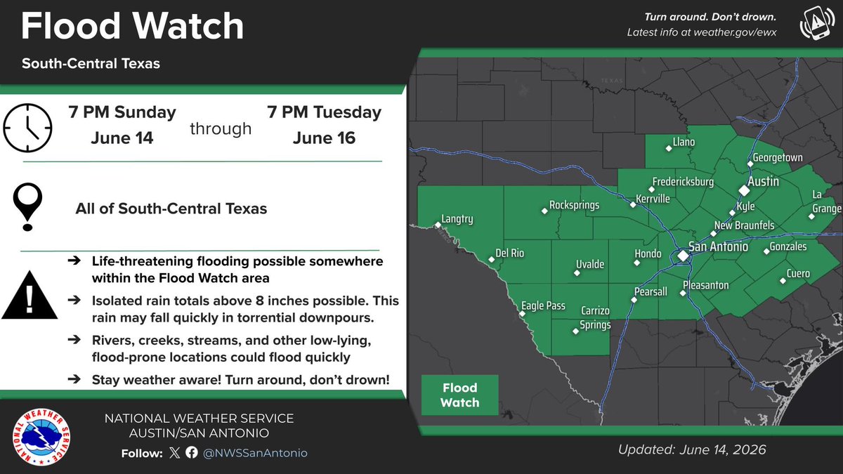
ALT National Weather Service graphic showing a Flood Watch in effect for South-Central Texas between 7 PM Sunday, June 14, through 7 PM Tuesday, June 16. The Flood Watch includes the Austin and San Antonio metro areas, portions of the Texas Coastal Plains, the Hill Country, and areas along the Rio Grande between Del Rio and Eagle Pass. Life-threatening flooding is possible somewhere within the Flood Watch area. Isolated rain totals above 8 inches are possible. This rain may fall quickly in torrential downpours. Rivers, creeks, streams, and other low-lying, flood-prone locations could flood quickly. Stay weather aware! Turn around, don't drown!
Warm, breezy conditions today kick off an extended stretch of humid heat for South Central Texas, with highs peaking near 104F in Del Rio later this week. Fortunately, a major spike in rain chances is on the way for Monday and Tuesday as a rare June cold front approaches.
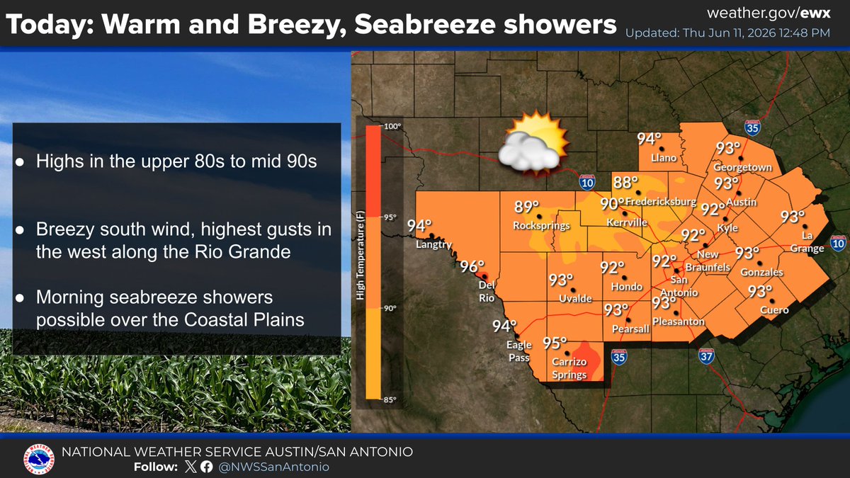
ALT This National Weather Service forecast graphic highlights a regional weather outlook titled "Today: Warm and Breezy, Seabreeze showers." The left panel details key bullet points: highs in the upper 80s to mid-90s, breezy south winds with the highest gusts along the Rio Grande, and possible morning seabreeze showers over the Coastal Plains. The right panel features a color-coded temperature map of South Central Texas, showcasing specific high temperatures ranging from 88°F in Fredericksburg to 96°F in Del Rio.
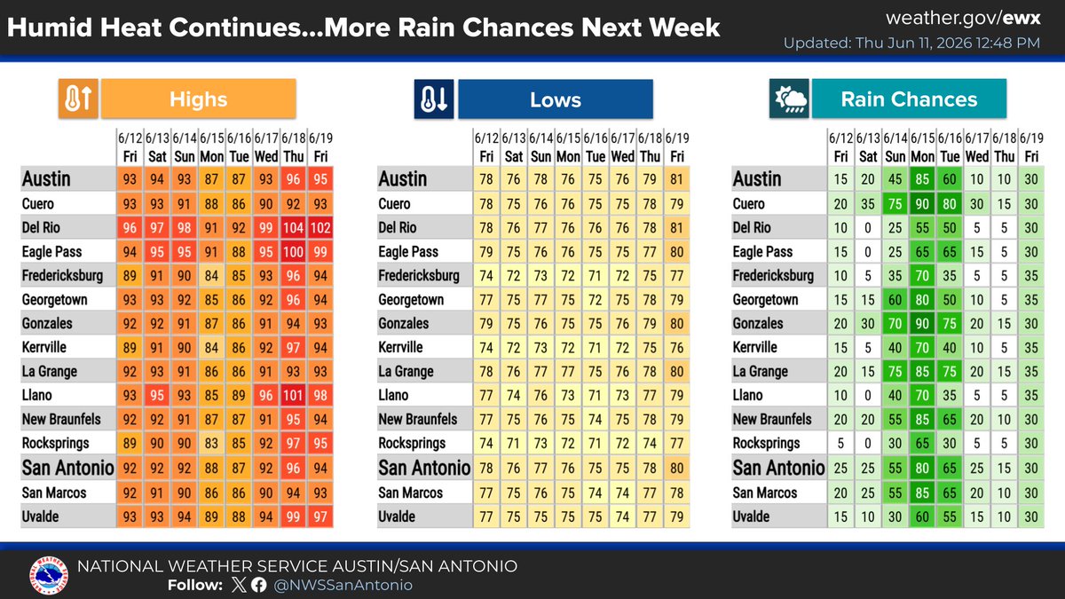
ALT This National Weather Service infographic displays an eight-day weather outlook for South Central Texas cities from June 12 through June 19, 2026. It is divided into three distinct, color-coded tables tracking daily high temperatures, low temperatures, and percentage chances of rain for sixteen regional locations. The data illustrates a trend of persistent humid heat with highs peaking as high as 104°F in Del Rio, alongside a notable spike in regional rain chances on Monday and Tuesday.
Don’t miss your chance to join our FREE two-hour Ready Together class! 🧑🏫
This session covers the four pillars of emergency preparedness and gives you practical tools to help protect yourself, your family, and your neighborhood in the event of a disaster.
¡No pierdas la oportunidad de unirte a nuestra clase GRATUITA de Listos Juntos! 🧑🏫
Esta sesión cubre los cuatro pasos de la preparación para emergencias y te brinda las herramientas prácticas para ayudarte a protegerte a ti, a tu familia y a tu vecindario en caso de un desastre.
Triple-digit temperatures are on the way. ☀️
Extreme heat can be dangerous, and the first 100-degree heat index day is when we see a spike in heat-related illness. Keep an eye out for a Warn Central Texas alert and know the signs of heat-related illness. 🌡️
Manténgase atento a las alertas de Warn Central Texas y conozca las señales de las enfermedades causadas por el calor. 🌡️
Este verano, toma suficiente agua y aproveche los Centros de Enfriamiento locales si necesita aliviarse del calor. 🌬️
⚠️ Before you or your pets get near Austin’s lakes & creeks, check the water first.
We have recently observed blue-green algae in different parts of Lady Bird Lake & Lake Austin. As temperatures rise through summer, we expect to see more algae growing in our waterways.
(1/4)
2:50PM update: Scattered storms with occasional lightning continue to roll across the I-35 corridor this afternoon and are beginning to enter the Hill Country, with some stations reporting a quick 1" of rain. These storms will continue north and west through the afternoon. #txwx
In excessive heat it is important to stay hydrated and take breaks in the shade. Knowing the symptoms of heat-related illnesses and what action to take can save lives. Find out more at: austintexas.gov/ready-centra…
En el calor excesivo, es importante mantenerse hidratado y tomar descansos en la sombra. Conocer los síntomas de las enfermedades relacionadas con el calor y qué medidas tomar puede salvar vidas. Obtenga más información en: austintexas.gov/ready-centra…
10:40 PM: Rain and storms continue for areas north of I-10 with more heavy rain moving across the Flash Flood Warnings in Northwestern Travis, Western Williamson and far northeastern Burnet counties. Additional flash flooding likely in these areas. Turn Around, Don’t Drown! #txwx
9 PM: radar coverage is still increasing slightly this evening over the eastern Hill Country, I-35 Corridor, & the Coastal Prairies. However, rainfall intensities have come down over the past hour. There is still a potential for flooding due to the soaked soils in the area.
7 PM: An axis of heavy rainfall has formed from western Williamson County south-southeastward across Austin and into portions of the coastal plains near Hallettsville. This corridor of activity is the greatest concern for the potential of flooding. Turn around, don’t drown! #txwx
During a storm, it’s hard to tell if there’s water on the road. If you encounter high water, don’t attempt to drive through it. If you must drive, stay away from creeks, trails, culverts, ponds, and other drainage infrastructure.
Check for road closures @atxfloods
Durante una tormenta, es difícil saber si hay agua en la carretera. Si se encuentra con agua alta, no intente atravesarla. Si tiene que conducir, manténgase alejado de arroyos, senderos, alcantarillas, estanques y otras infraestructuras de drenaje.