
Storm Chaser Connor Croff |22|loves to get stuck in mud/ditches | Business Contact : Cdubs100@gmail.com
Joined March 2020
- Tweets 16,707
- Following 665
- Followers 32,064
- Likes 19,526
Photos and videos
Pinned Tweet

9 Aug 2021
I told grandma I would get her a tornado. MEMA DOMINATING

113
356
4,941
I might get into the business of sending hacking links seeing how easy it is to get this community to click them
5
1
88
6,136
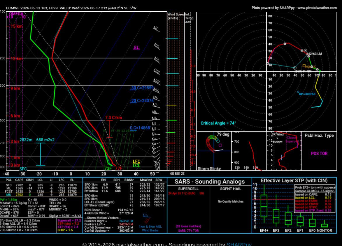
Wednesday is the most insane kinematic environment I have ever seen modeled.

32
28
495
63,469
Why is TikTok full of El Niño panic right now? Like why are we scared of El Niño there have only been 10 billion El Niños before this one and we are still here.
32
6
279
15,236
Jun 13
All I’ll say is omega has never not paid me on time🤷♂️. Not sure why these radar apps pay most chasers what they do anyway. If you don’t have large audience to promote the app to and get a positive ROI with subscriptions, then you are virtually worthless to them anyway. Just a basic business principle.
8
10
250
27,268
Jun 12
1 week
5800 miles
And the tornado I was looking for was 1 mile from my house
56
50
1,739
52,532
Jun 12
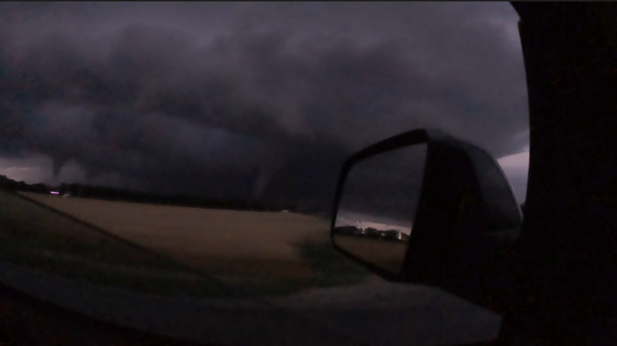
Twin tornadoes NE of Kouts, IN last night. My dad has the entire life of the tornado recorded on the new go pro mission 1.
40
61
843
30,574
Jun 12
Tonight is without a doubt the craziest night of my life. The Hebron/Kouts tornado missed my house by a mile. An hour beforehand, my dad went out to go storm spot. He had one phone and a go pro. He sent his stream to me with his phone and recorded with his go pro as I navigated him from Illinois on the phone. He streamed nearly the entire lifespan of that tornado bringing SW of Hebron and ending near Wanatah. No radar, no maps, just my direction as he hooked sliced through the RFD of a strong tornado. Thanks to him, and @StormCat5_, my community was able to have 15 minutes of visual advanced notice that the tornado was coming. Remarkably a failed occlusion saved my town as the tornado shot northward before continuing east.
72
113
2,632
93,544
Jun 11
Also need to note it’s June not April so recovery is still likely, possibly just not to the northern extent being forecasted similar to yesterday. I-80 corridor is still in play for tornadic supercells imo.
Jun 11

Bump
Would be very cautious looking at any cams that don’t have this level of MCS coverage this morning.

8
2
88
20,244
Jun 11
Bump
Would be very cautious looking at any cams that don’t have this level of MCS coverage this morning.
Jun 11
I have a hard time believing any MCS tomorrow morning over central Iowa is just going to vaporize by early afternoon. Hard to buy into a setup based on a derecho decaying when models are notorious for undergoing MCS strength and longevity. We will see in the morning!
8
3
151
55,328
Jun 11
I have a hard time believing any MCS tomorrow morning over central Iowa is just going to vaporize by early afternoon. Hard to buy into a setup based on a derecho decaying when models are notorious for undergoing MCS strength and longevity. We will see in the morning!
10
6
162
46,051
Jun 11
This doesn’t include the almost head on collision with a dodge charger or the fact I was trying not to throw up for 2 hours driving through the hills lol. Tomorrow is a new day!
Jun 11
Come along on today’s chase with me!
Wake up at 8am
Drive 7 hours to Bethany, MO
Watch the future unionville storm go up
Track with it for 30 min
Leave it because it looses all low level rotation and scud
Gets to St.Joe cell
Storm I left produces massive tornado
St Joe cell produces uncondensed tornado
Knocks over a few trees in my east route
Drives south to next east route to see it’s blocked by a bridge out
Goes even further south to find the south road also has a bridge out
Storm produces fully condensed tornado as I am catching up
Does nothing for an hour
Rotation starts ramping up
I see a nice short cut gravel road option through some rough terrain
Yet another bridge out
Goes south 5 miles to the next east road
Falls behind again
Says fuck this it’s outflow dominant anyway and leaves
Storm produces large wedge tornado
Easily the make frustrating storm chase of my life to date
6
4
118
13,702
Jun 11
Come along on today’s chase with me!
Wake up at 8am
Drive 7 hours to Bethany, MO
Watch the future unionville storm go up
Track with it for 30 min
Leave it because it looses all low level rotation and scud
Gets to St.Joe cell
Storm I left produces massive tornado
St Joe cell produces uncondensed tornado
Knocks over a few trees in my east route
Drives south to next east route to see it’s blocked by a bridge out
Goes even further south to find the south road also has a bridge out
Storm produces fully condensed tornado as I am catching up
Does nothing for an hour
Rotation starts ramping up
I see a nice short cut gravel road option through some rough terrain
Yet another bridge out
Goes south 5 miles to the next east road
Falls behind again
Says fuck this it’s outflow dominant anyway and leaves
Storm produces large wedge tornado
Easily the make frustrating storm chase of my life to date
25
9
350
33,547
Jun 10
Good adjustment in the new outlook!
Jun 10
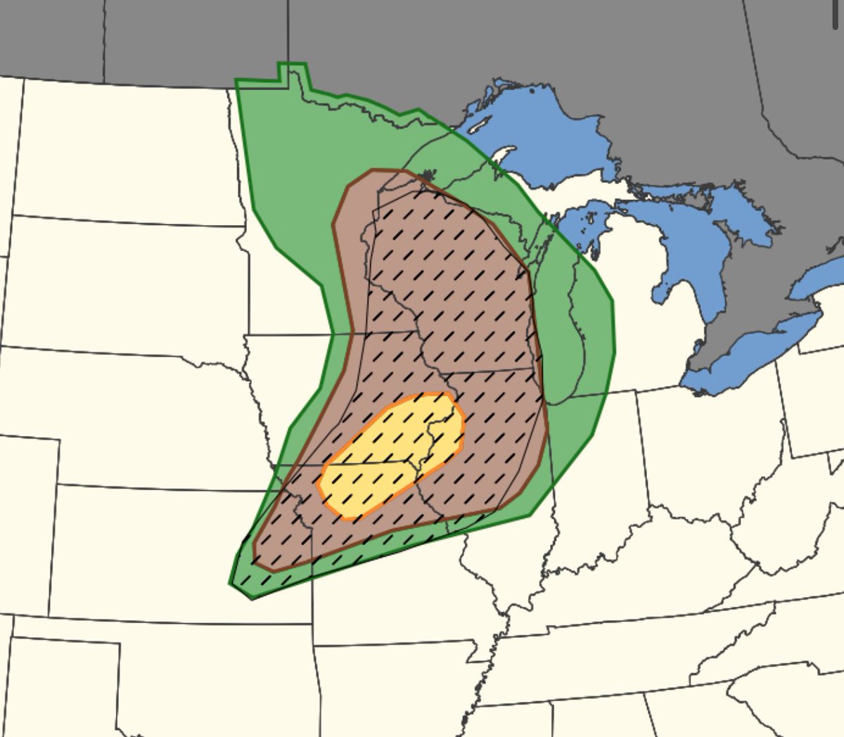
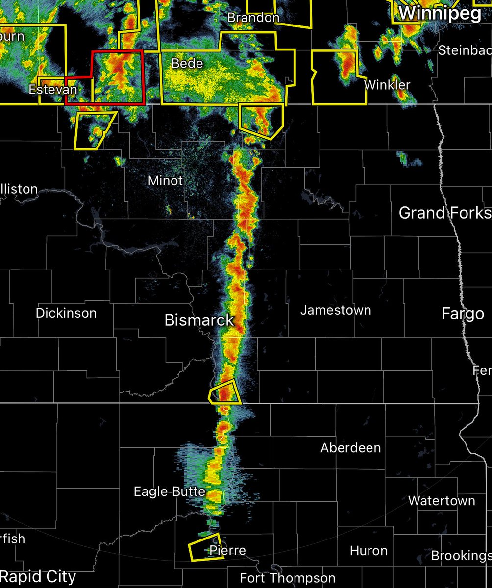
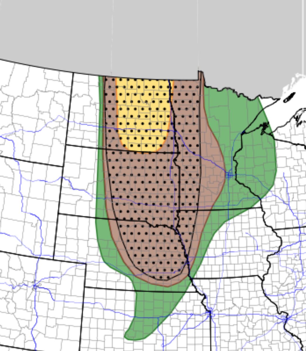
Yesterday around this time, today looked like it could verify as a 10# tornado risk.
This morning however, this is no longer the case. If you are in WI/MN the threat of strong tornadoes and even tornadoes at all is now very low. Most people won't have the balls to tell you this but I am not afraid to be wrong. If you are in WI/MN today is a low/mid range severe weather day that will happen 10 more times this summer. Expect one or two weak tornado reports. This is what the tornado probability should look like today. Could see a world where a 10 CIG1 verifies in my 5% zone. We will see if the SPC adjusts or if they go down with a sinking ship.
9
6
236
31,967
Jun 10
Yesterday around this time, today looked like it could verify as a 10# tornado risk.
This morning however, this is no longer the case. If you are in WI/MN the threat of strong tornadoes and even tornadoes at all is now very low. Most people won't have the balls to tell you this but I am not afraid to be wrong. If you are in WI/MN today is a low/mid range severe weather day that will happen 10 more times this summer. Expect one or two weak tornado reports. This is what the tornado probability should look like today. Could see a world where a 10 CIG1 verifies in my 5% zone. We will see if the SPC adjusts or if they go down with a sinking ship.
40
14
297
64,274
Jun 10
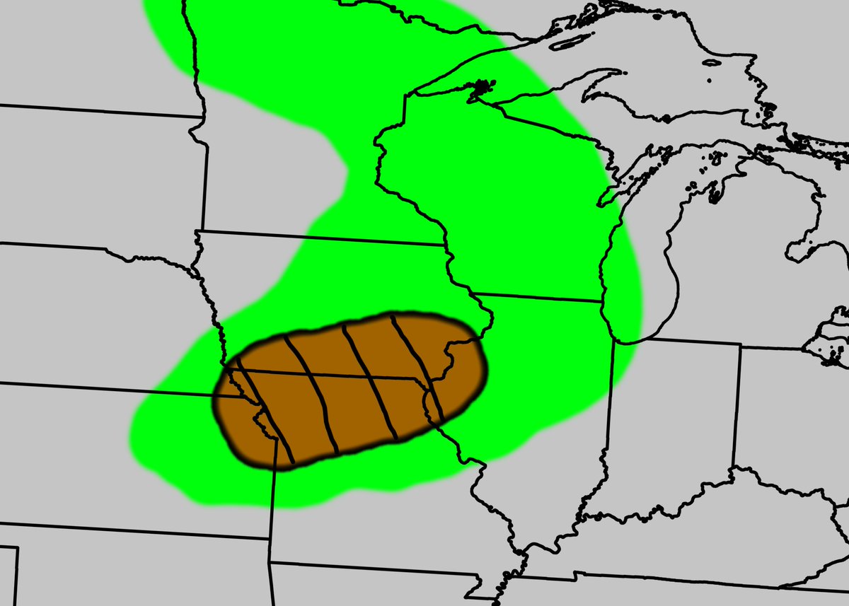
If I were the SPC today the northern half of the 10# would be removed for today and I would be going with a D2 wind driven moderate tomorrow from central Iowa to Lake Michigan. Tomorrow in my opinion has a real chance to verify as a high risk cig 2/3 wind event. Very dangerous day tomorrow.
19
10
211
17,795
Jun 10
Yesterdays severe weather setup to today’s a setup

9
3
156
7,498
Jun 10
Fighting everything in me to not roll over and go back to bed, but here we go I guess
12
1
221
27,734
Jun 10
On a real note why was this 10# not removed 24 hours ago. Don’t think I talked to one person this morning who understood why it was still in place.
6
4
195
34,633