
One-stop shop for in-depth forecast discussions and case studies for upcoming and past severe weather events across the United States.
Joined April 2022
- Tweets 6,975
- Following 898
- Followers 12,720
- Likes 14,076
1,936 Photos and videos


Pinned Tweet

LINK: youtube.com/watch?v=VuPkueBv…
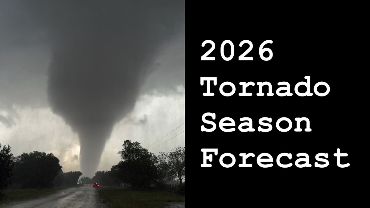
My 2026 Tornado Season Forecast is live! In it, we discuss the factors that tend to modulate tornado frequency and distribution in the US from March-June and how they’re expected to evolve through the season. We'll then take a look at several analog years that had similar background conditions to this year to make a month-by-month forecast for tornado activity this spring.
26
56
309
116,181
🎙️ LIVE Group Coaching session for @TornadoCoaching tonight at 8 ET!
I’ll be running a Forecast Challenge and answering all of your questions. 💬
This event is for Chaser Academy members.
👉 Become a member here: youtube.com/channel/UCCP12NY…
👉 Join Discord here: discord.gg/stormchasercoachi…
1
7
987
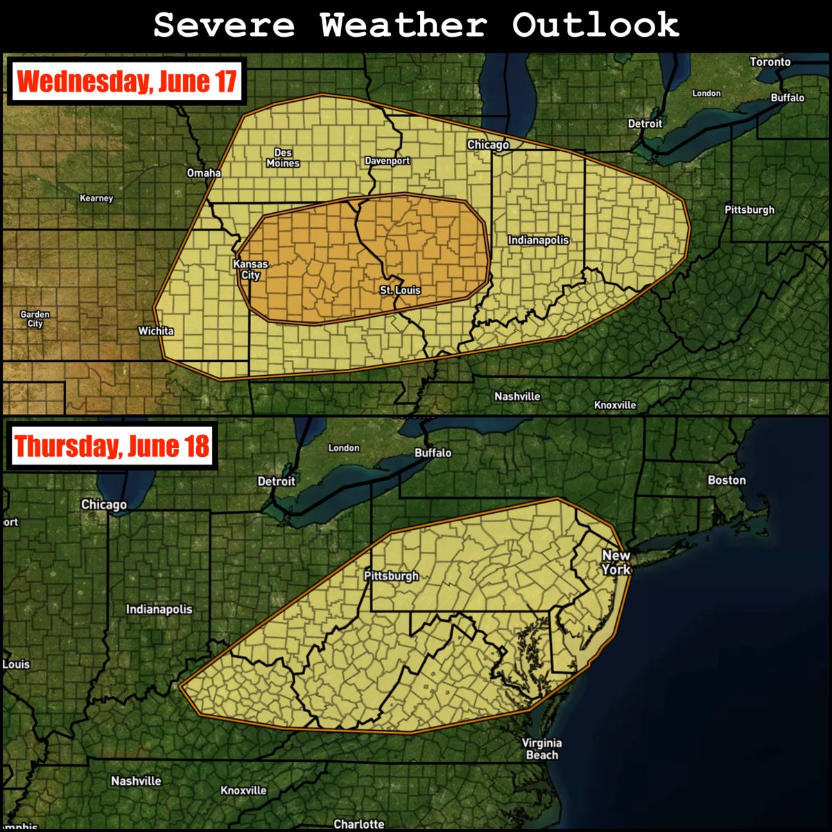
A potent severe weather sequence appears likely Wednesday and Thursday of this week (June 17-18). SPC has highlighted risk areas for each of these days, with Wednesday featuring an Enhanced Risk-equivalent 30% area focused on parts of Missouri and Illinois. Models are honing in on a potentially significant all-hazards event on Wednesday across this area, with the threat shifting east on Thursday. I plan on uploading a video with my initial thoughts on the setup tomorrow.
2
11
87
3,782
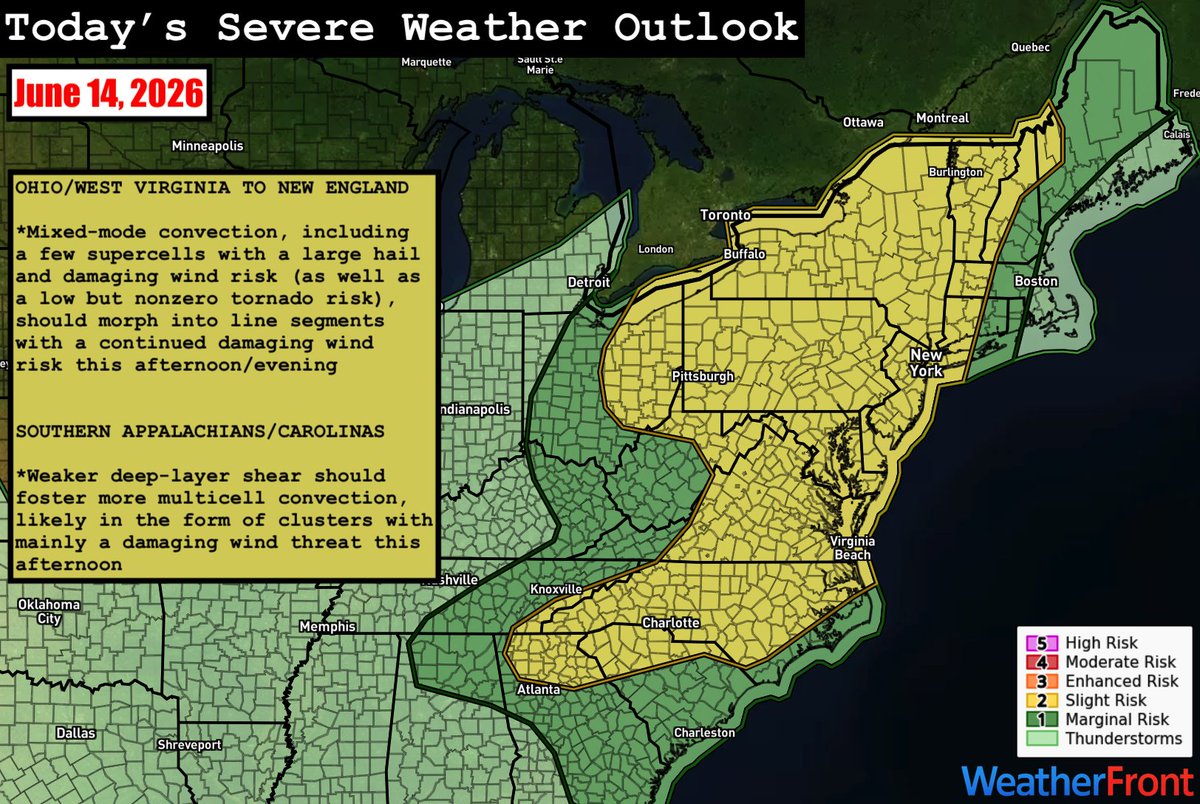
The eastern US is the focus of the severe weather threat today; SPC has outlined a Slight Risk (level 2/5) from New England to the Southeast. With northward extent, stronger deep-layer shear should foster mixed-mode convection, including supercells, before upscale growth into line segments occurs. Large hail and damaging wind will be the main threats, but a tornado or two is also possible. Across southern portions of the risk area, weaker deep-layer shear should yield multicell clusters with mainly a damaging wind risk.
1
6
28
1,713
LINK: youtube.com/watch?v=FB0ky528…
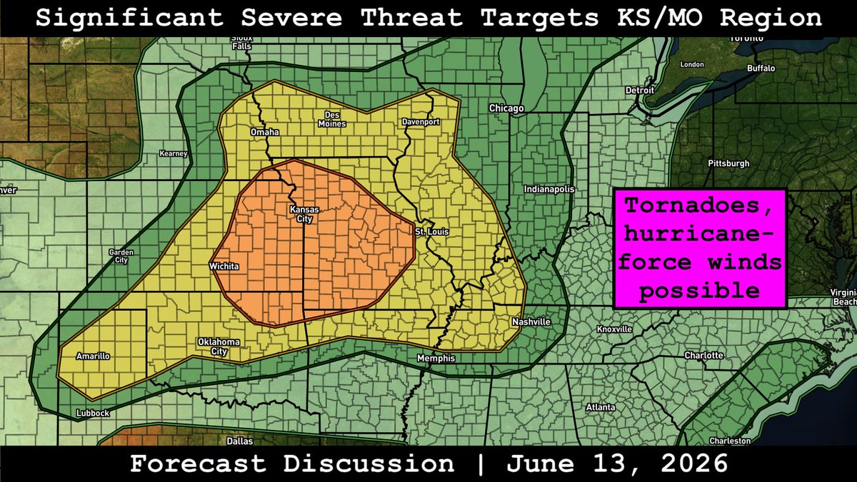
Forecast discussion on today's significant severe threat focused on the Kansas/Missouri region. Supercells are expected to develop this afternoon near a southeastward-sagging cold front and remnant outflow boundary, eventually morphing into an intense MCS with time. All hazards are possible.
2
7
51
2,000
Two areas of heightened severe potential exist today:
1) East Coast: Despite relatively weak deep-layer shear, clusters of strong to severe storms are expected to develop this afternoon, posing a risk for mainly damaging winds and perhaps isolated instances of large hail.
2) Southern High Plains: Initial supercells with the potential for large hail/damaging winds (and perhaps a tornado or two) are expected to develop across SE Colorado/NE New Mexico before congealing into an eastward-moving convective complex with continued damaging wind potential this evening.
3
31
1,760
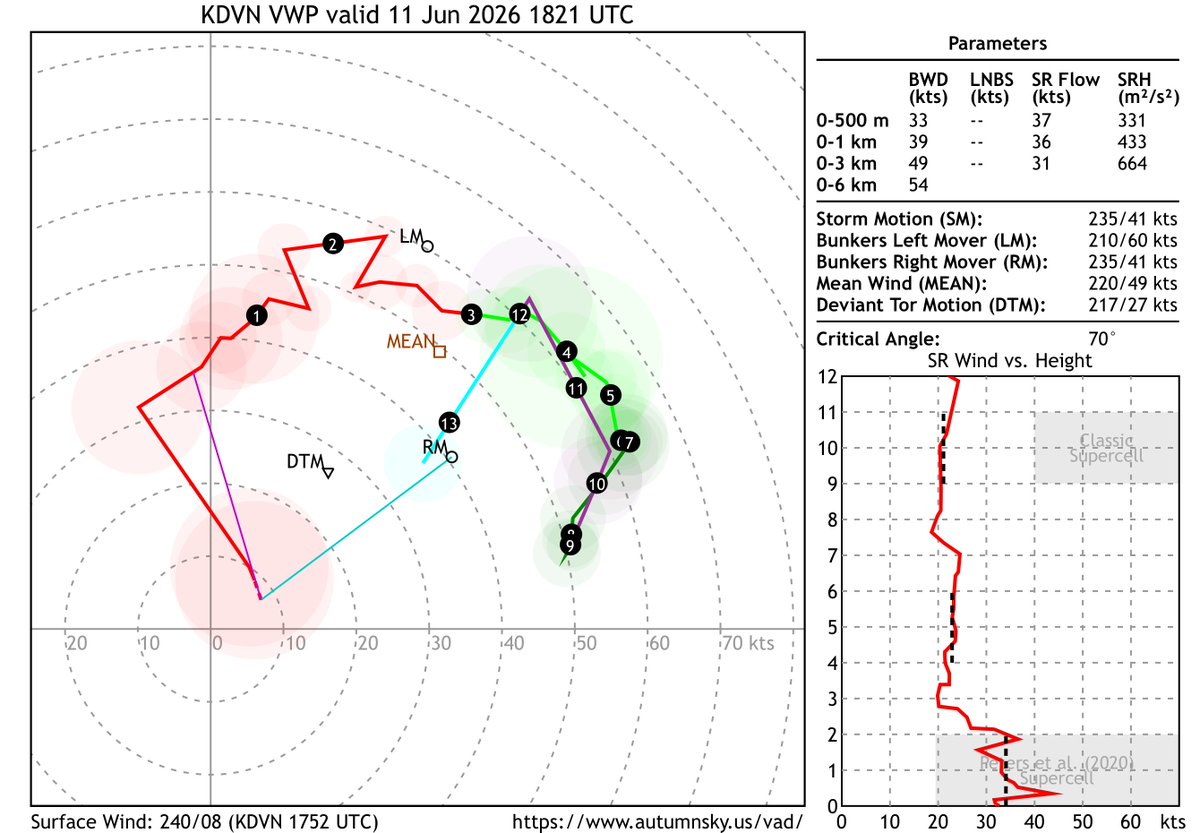
Today definitely deserves a breakdown video. Bottom line: never underestimate a wind profile like this, even if the thermos aren't perfect.
VWP | Davenport, IA | 1821z
16
32
396
13,702
LINK: youtube.com/watch?v=D0kBUCwo…
Forecast discussion on today's Moderate Risk severe weather outbreak that's already underway and expected to peak this afternoon across the Midwest/Great Lakes. In the wake of a robust morning MCS, supercells with an all-hazards risk, including a threat for intense tornadoes and hurricane-force wind gusts, are forecast to develop.
3
8
51
2,448
LINK: youtube.com/watch?v=ufWpYBqG…
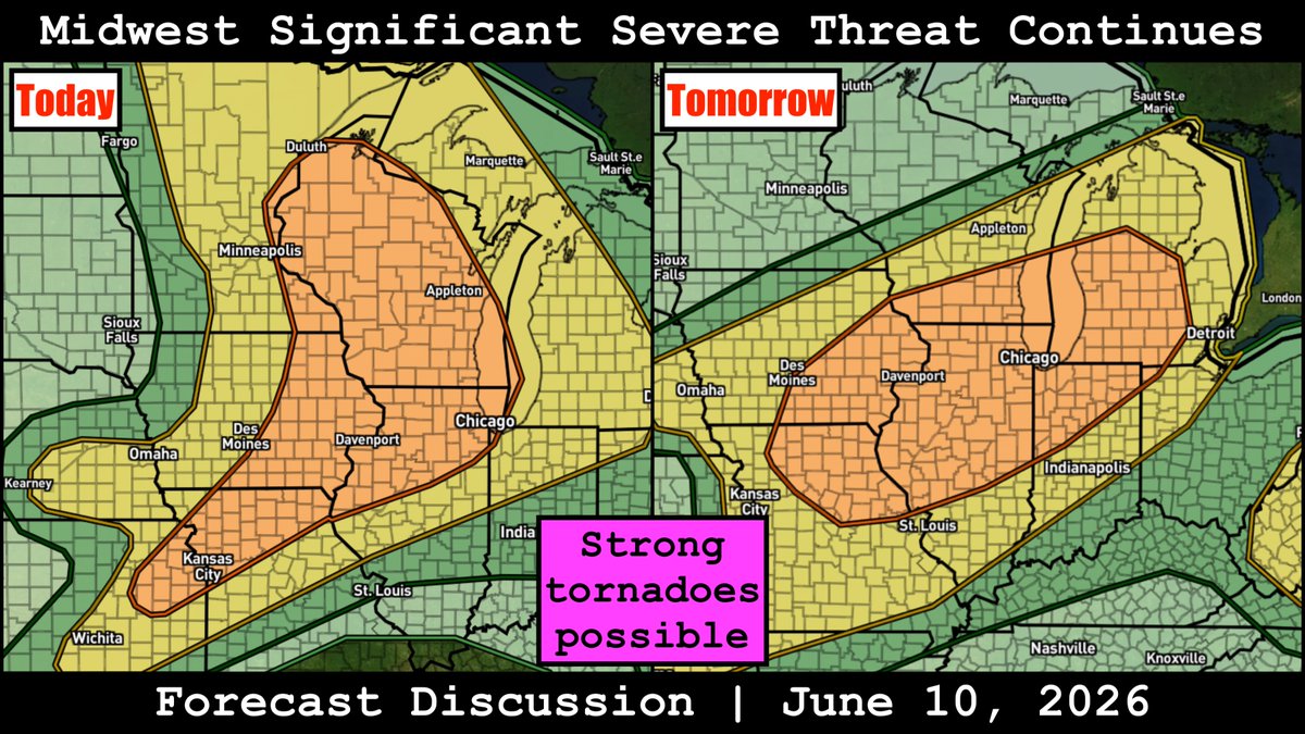
Forecast discussion on the complex, significant severe weather setups today and tomorrow centered on the Midwest. Multiple rounds of storms with the potential for all hazards, including strong tornadoes and significant damaging winds, are likely over the next couple days.
3
9
64
5,723
LINK: youtube.com/watch?v=4qheHcu4…
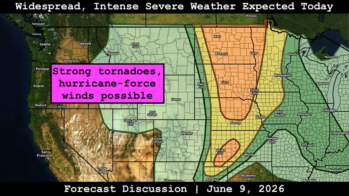
Forecast discussion on today's widespread, intense severe threat expected from southern Canada into the central/southern Plains. An intense MCS is expected to roll across the Dakotas with a significant damaging wind/tornado risk, with a conditional risk for all-hazards supercells ahead of the line.
4
10
57
3,259
LINK: youtube.com/watch?v=d-oaEoqO…
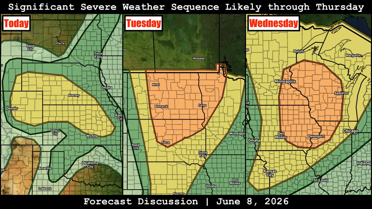
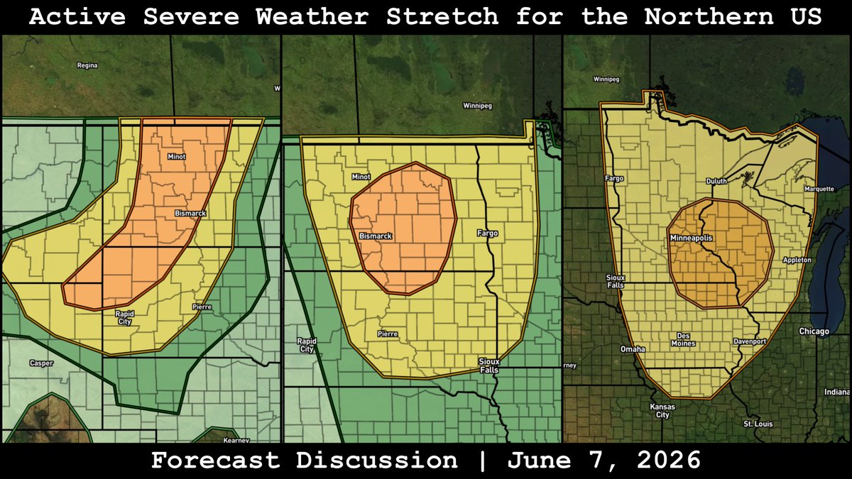
In-depth forecast discussion on the significant severe weather sequence that continues today through at least Thursday across the central and northern US. Multiple days of significant all-hazards potential appears to be on tap.
8
10
54
5,288
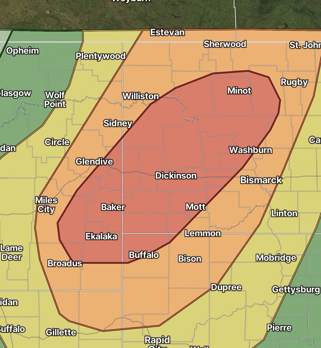
SPC has upgraded to Moderate Risk (level 4/5…red area below) across SE Montana, NW South Dakota, into western North Dakota today. Confidence is increasing in an intense bowing MCS traversing the area this afternoon/evening, posing a risk for widespread intense damaging wind gusts up to 100 mph. A derecho is possible.
2
6
61
2,375
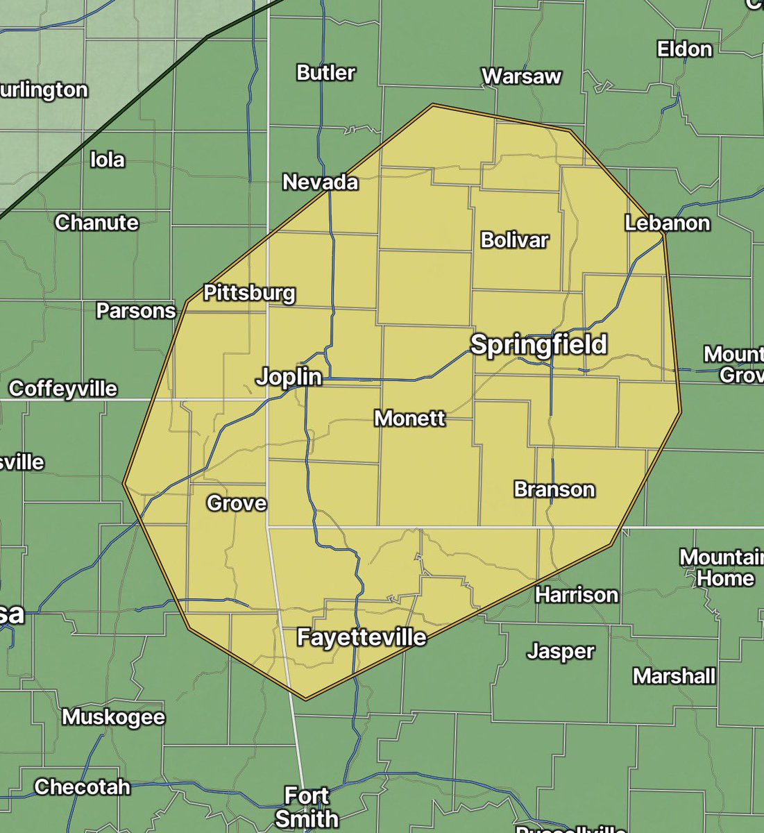
SPC has added a Slight Risk (level 2/5) in the SW Missouri vicinity today. A few transient supercells with a threat for a brief tornado or two and isolated damaging wind gusts are possible this afternoon.
2
2
22
1,504
LINK: youtube.com/watch?v=yPWm61i4…
Forecast discussion on the active stretch of severe weather that continues across the northern Plains into Canada over the next few days.
3
7
67
3,291
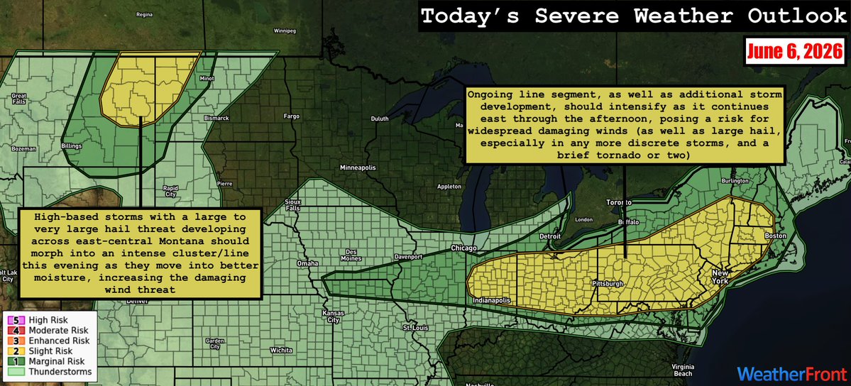
SPC has outlined Slight Risks (level 2/5) in two areas today:
1) NE Montana/NW North Dakota: a mix of high-based multicells and supercells are expected to develop this evening, rapidly developing into an intense cluster/line segment. Large hail and damaging winds will be the main threats. This risk extends up into SE Saskatchewan, where a High Risk (level 3/4) has been outlined by Environment Canada. Here, a few supercells with an all hazards threat are possible today before the threat shifts east into southern Manitoba tomorrow.
2) Indiana to New England: Ongoing convection, as well as any new storm development, should intensify through the afternoon as it moves east, posing a risk for widespread damaging winds and perhaps a brief tornado or two. Large hail is possible with more cellular convection.

4
28
2,283
SPC has outlined a Slight Risk (level 2/5) from the Kansas/Nebraska border eastward into Illinois today. Large scale forcing for ascent will be weak, but storms may initiate along a frontal zone draped across the region by early evening. These are likely to be supercells with a large hail/damaging wind risk, along with a low but nonzero tornado risk. With time, they should congeal into clusters/line segments.

2
3
24
1,315
LINK: youtube.com/watch?v=xxGRFWGt…
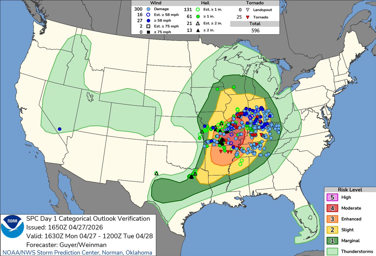
In-depth breakdown of the Moderate Risk severe weather event from April 27, 2026. SPC issued a PDS Tornado Watch with the expectation of several strong/intense tornadoes, but the tornadoes that did happen were weak and generally brief. We'll discuss the meteorology behind the event with a focus on the reasons why the event underperformed significantly in the tornado department.

11
28
125
8,515
Widely scattered convection is expected across the Slight Risk (level 2/5) area today, including a few supercells. This risk is greatest across SE Montana/NE Wyoming into western South Dakota within an upslope regime coinciding with modestly enhanced flow aloft. Large hail/damaging winds will be the greatest risk with this activity.
Another area of concern is in the NE Kansas/SE Nebraska vicinity ahead of an MCV currently in northern Kansas. The degree of destabilization ahead of this feature is in question given current convection/cloud coverage, but should robust storms develop, damaging winds and a brief tornado or two would be possible.

3
6
39
2,094
To be released tomorrow. Stay tuned!

Work has begun on my breakdown of the April 27, 2026, Moderate Risk severe weather event across the Midwest and Mid-South. Forecasts called for numerous supercells with intense, long-track tornadoes, particularly in the open warm sector, but this did not materialize, as warm sector supercells failed to sustain. Of the ~22 tornadoes that occurred from the afternoon of the 27th into the morning of the 28th, all were weak and most were short-lived. In this video, we'll discuss the meteorology behind the event, including several reasons why the event significantly underperformed in the tornado department. Stay tuned!
6
7
73
4,234
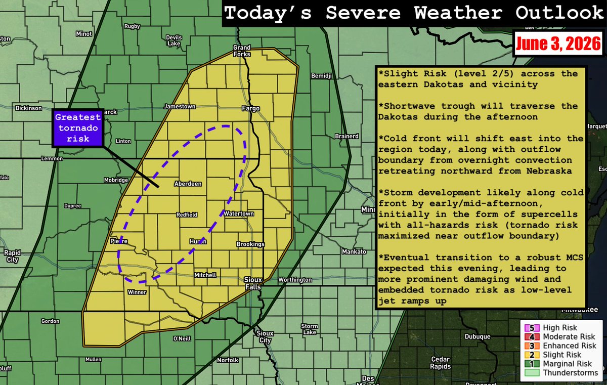
SPC has outlined a Slight Risk (level 2/5) today across the eastern Dakotas, far northern Nebraska, and far western Minnesota. Supercells with an all-hazards risk are expected to develop along an eastward-shifting cold front before morphing into a robust MCS with damaging wind/embedded tornado potential this evening. Tornado potential may be maximized near a subtle, northward-retreating outflow boundary across South Dakota.
2
7
34
1,928