
Chief of Staff, Driveline Baseball
Joined February 2024
- Tweets 1,181
- Following 320
- Followers 222
- Likes 2,967
29 Photos and videos


Emily Coolbaugh retweeted

Same view, just skelly version
Where bat speed peaks (dark red) is great insight on where you hit the ball well (deep or out front)
Jun 15

A little Miz Monday action
iPitch set to Misiorowski's avg Fastball from his avg release point with Leather Smash Balls
1
2
6
2,305
Emily Coolbaugh retweeted

Jun 15
John Rave just got the call from Kansas City 👏 here's the offseason work!
Head over to our YouTube channel for a look at Rave's full cage session alongside @_Chrisleone
Link Below ⬇️
1
9
18
8,215
Emily Coolbaugh retweeted
Day 1 hitter walks into the gym.
What do you see and where do you start?
1
2
8
4,587
Emily Coolbaugh retweeted

Jun 14
Swing Design Highlights w @NoahCoy3
Noah is coming off a big sophomore year at Notre Dame. After getting reassessed and reviewing his season, there were certain things we wanted to address to get even better.
- Flatten path
- Lower ball flight
- Use Pull Side better
Thread⬇️
1
10
14
1,449

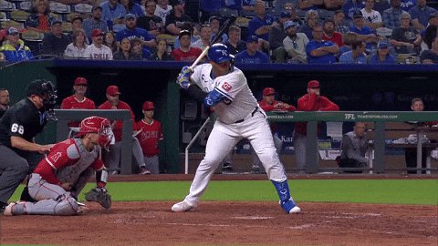
Jun 14
Sad for Vin, happy for John.
Jun 14

We have made the following roster moves:
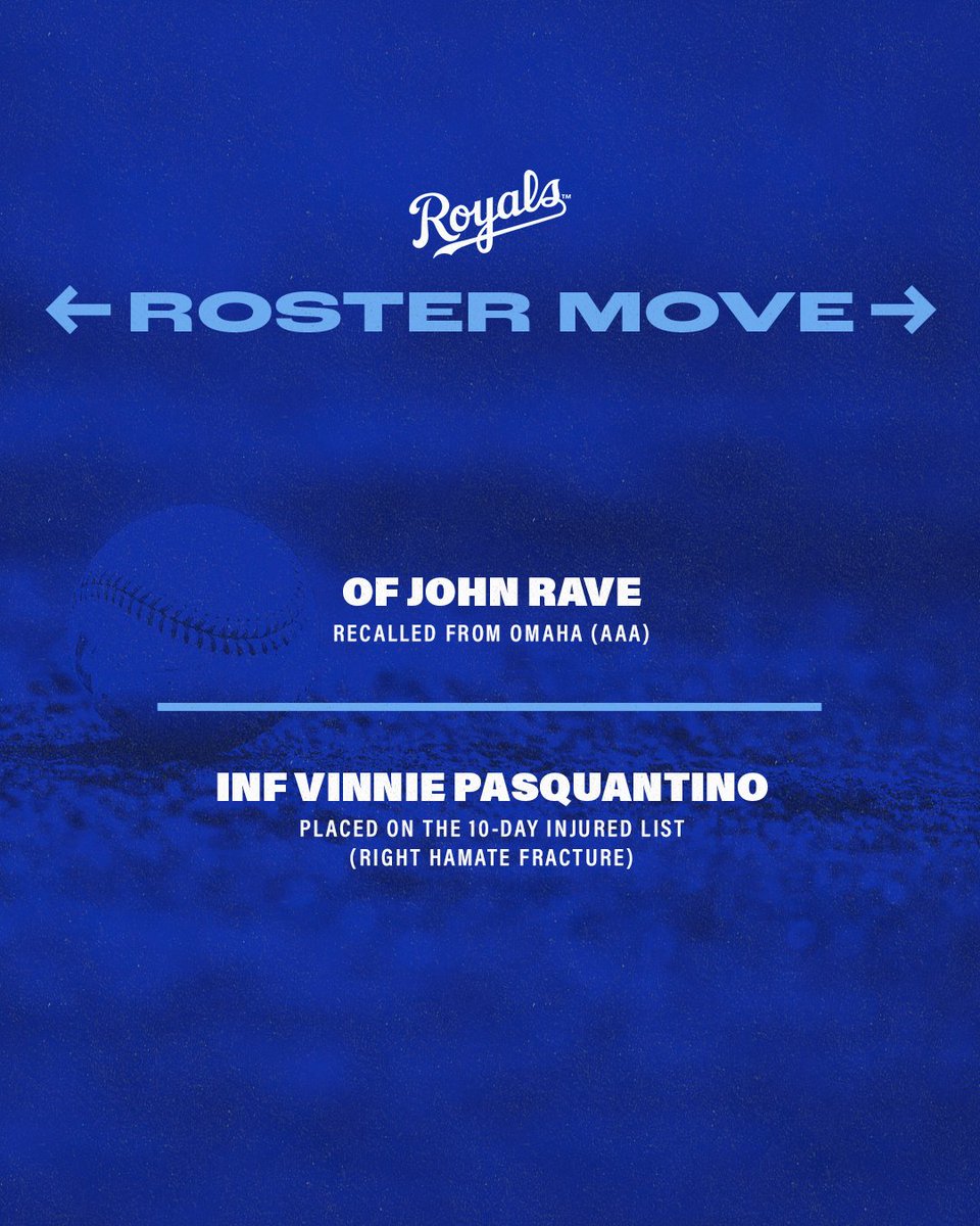
ALT Royals Roster Moves: - Recalled Outfielder John Rave from Omaha (AAA). - Placed Infielder Vinnie Pasquantino on the 10-Day Injured List with a right hamate fracture.
2
130


Emily Coolbaugh retweeted

Jun 13
Your sequencing plays a big role in how your bat moves through space.
8
19
2,557
Emily Coolbaugh retweeted

LOUD day on the floor yesterday
94-97 Heaters incoming
Cue was get your A swing off a ball above where they think the pitch is
Fellas came ready
College Summer in full swing
2
15
33
16,506
Emily Coolbaugh retweeted

13
215
1,883
52,717
Emily Coolbaugh retweeted

Jun 10
A year's worth of progress for transfer portal OF @ParkerEastwood1
A well executed training plan has led to some serious gains over the last year
10 mph of bat speed 🔥
14 mph of max exit velocity 🔥
Progress that showed on field with his OPS jumping 258 points from last season. Somebody is getting a good player out of the portal ‼️

Officially entering D1 June 1st Transfer Portal 🚨
6' 200lbs / 19yrs / RH OF / 2yrs eligibility, 3 if 5 yr rule
.300 AVG | .900 OPS | 17 XBH | 5 HR | 110 PO
@carsonevanss @Bsbclips @prospectdugout @UncommittedStud @BaseballFactory @D1ProScouts
#D1Baseball #TransferPortal
2
16
24
13,473
Emily Coolbaugh retweeted

Jun 11
🚀

1
4
343
Emily Coolbaugh retweeted
Jun 11
🚀⚡️


1
5
9
4,714
Emily Coolbaugh retweeted
Jun 10
Command isn't a motivation problem. It's a skill, and your misses have a shape.
Intended Zones Tracker measures every pitch against the target so you can see exactly which way you skew and what your biggest weaknesses are.
Driveline Roadmap takes that data and turns it into a plan, so command stops being a vague label and becomes something you can actually develop.
1
5
21
10,331
Emily Coolbaugh retweeted
Congrats to RHP and former Pitching Intern @bgillispitching on signing with the Washington @Nationals!
Atta boy, Brock 💥
Swipe to see Brock's live ABs from this past offseason ⬇️

15
46
14,287
Emily Coolbaugh retweeted

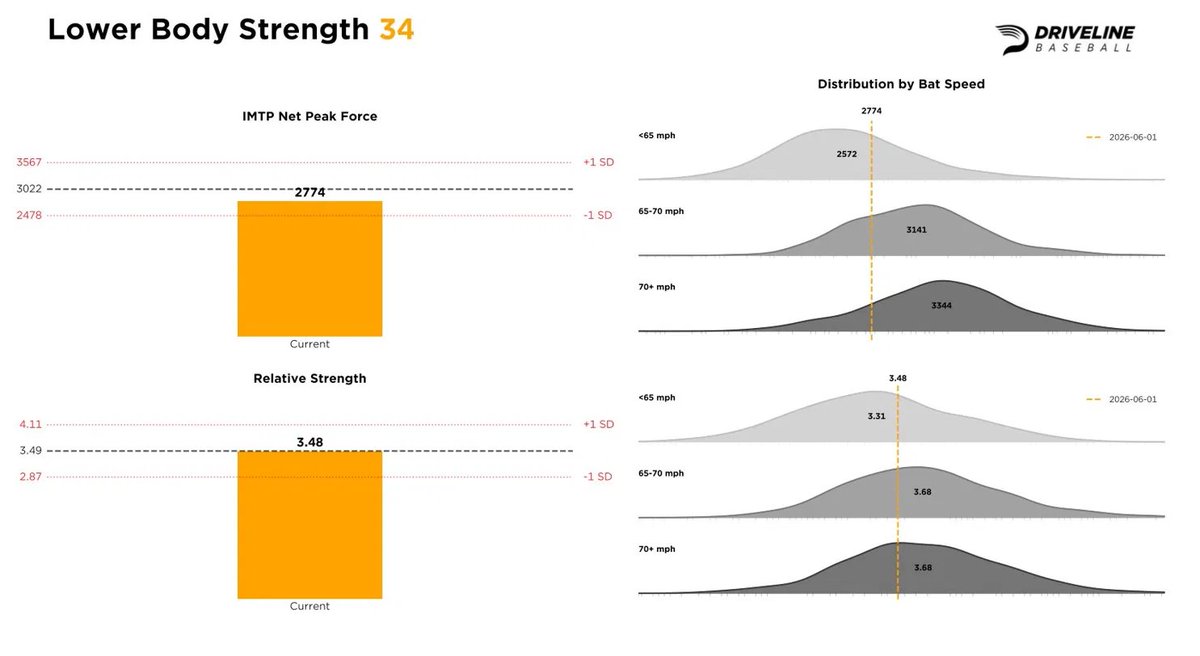
The CWS shows the level of talent and physicality it takes to play at a high level. Guys hitting 430 . Pitchers sitting low to mid 90s.
Where does your physical output stack up against guys swinging 70 or throwing 90 ?
Knowing where you stand is what shows you where to go.
3
21
2,233
Rinse and…
Jun 8

❗Charge the phones and have flash lights ready? May not be a bad idea tonight.
A complex of thunderstorms is expected to sweep across northern, central, and eastern Kansas this evening and overnight. Initially, individual rotating thunderstorms may produce extremely large hail, destructive wind gusts, and the potential for a tornado. This is most likely across the Enhanced Risk area (level 3 out of 5) west of Topeka, Kansas.
There is still some uncertainty about how much strength the thunderstorms will maintain as they reach Kansas City and western Missouri overnight, around 11 PM to 1 AM, give or take an hour. For the Kansas City metro, the greatest concern is damaging thunderstorm wind gusts up to around 75 mph, with a lower, but not zero, chance of large hail or a tornado.
I've included the risk categories, as well as damaging wind and tornado probabilities. Note that the greatest potential for the most significant severe weather is west of Kansas City. Nevertheless, let’s err on the side of caution and remain alert by checking the forecast before going to bed this evening and having ways to receive weather alerts, such as the KMBC app (leave your ringers turned on), a NOAA Weather Radio, and Wireless Emergency Alerts (WEAs) on compatible smartphones.
Posted Monday afternoon June 8, 2026


34
Emily Coolbaugh retweeted

Jun 8
.@BrandonDim24 knows no fear when it comes to player development.
Just a guy who gets it.
Mar 11

What are you willing to do for your athletes to help them get better?
1
2
12
2,695
Emily Coolbaugh retweeted

The KBO and NPB are no longer graveyards for expat pitching careers -- they've become springboards: mlb.com/news/unpacking-pitch…
1
38
138
20,610
Emily Coolbaugh retweeted

Jun 6
Dark red = good player @Matty_Brown24

I have officially entered the transfer portal after 2 seasons at North Greenville.
• 20-3
• 2.51 era
• 168 IP
• K/BB- 141/33
2
1
4
4,748