
Data, maps, apps, and consulting services for effective #broadband decisions. 🌐 Employee-Owned.
Joined January 2012
- Tweets 374
- Following 89
- Followers 316
- Likes 76
265 Photos and videos


Broadband is starting to heat up and so is The Current. ☀️
Data and market conversations are telling an important story, shifting how industry players are thinking about the future.
In the June edition of The Current, we cover what we're seeing:
🔹 Acceleration of competition in cable markets – locations where cable is the only high-speed option have dropped nearly 36% in two years. What does this mean for ISPs?
🔹 One message is standing out: provider growth is trending towards customer acquisition and retention, not just expansion. Three market shifts reshaping how ISPs compete in today's broadband landscape.
🔹 More providers are using data to strengthen targeting, planning and competitive strategy. What data are they using to drive results?
🔹 In-depth Fabric knowledge is critical to implement effective strategy, reporting, compliance and operations workflows. Is there potentially Fabric information you could be missing?
🔹 AI and edge infrastructure are creating new demands on broadband networks. Cher Rowland Henton is posing a question: as the race to reduce AI latency intensifies, could the coffee shop on your corner be the next target for edge computing infrastructure?
🔹 Brian Allenby and other experts are seeing important trends to follow from BEAD execution realities and mounting cost pressures to what's happening on the ground as the buildout moves from planning to construction.
🔹 Network cost updates are in the works to support USF grant decision-making. *Webinar with NTCA & Dan Gordon will review details.
More insight is better than none to navigate the shifting tides in today’s market.
👇 Subscribe below and never miss an edition.
costquest.info/newsletter
37

May 29
As many of you know, broadband maps are only as useful as the accuracy and detail behind them. Before the BDC, coverage was reported at the census block level, sometimes marking locations as served and missing unserved and underserved locations.
The National Broadband Location Fabric dataset introduced a structure-level view of coverage mapping by focusing on first pinpointing every Broadband Serviceable Location in the country. To create it, CostQuest cleans and weaves together millions of data points from: parcel, satellite imagery, building footprints, addresses, land and tax attributes, and road data sources.
The result: over 116 million locations mapped to the rooftop, enabling coverage and other data to be overlayed on top for a clear view of available service, who's providing it, where federal funding is being deployed instead of broad assumptions across larger geographic areas.
When the picture is clear, the decisions that follow are stronger. Listen to CostQuest's Director of Data, Alex Meyer, discuss the creation of the Fabric in more detail. ⬇️
30
May 28
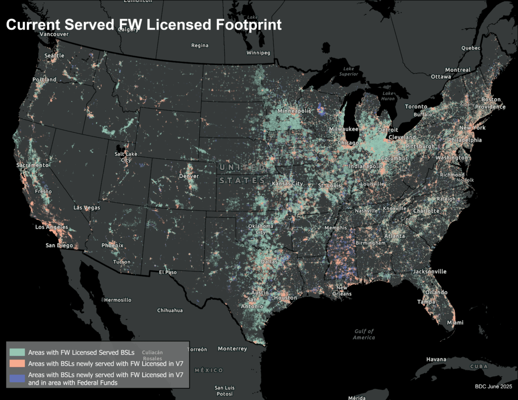
Fixed Wireless Access (FWA) has earned its place in the American broadband landscape. What happens next will define its long-term role.
Key #BroadbandinAmerica insights:
🔵 FWA has scaled into a mainstream broadband alternative, but sustainable growth increasingly depends on a disciplined "sell where you can serve" approach, with carriers dynamically gating address-level eligibility based on available tower capacity. Regional WISPs remain an active competitive force, particularly in rural and hard-to-reach markets.
🔵 AT&T posted the highest FWA growth rate among the Big Three, nearly doubling its served locations from 1.9 million to 3.8 million BSLs – a 98.5% increase – driven by Internet Air and broader 5G expansion.
🔵 5G coverage grew approximately 4% since December 2024, while legacy 3G coverage dropped 28% as carriers refarm spectrum for more efficient 4G and 5G use.
🔵 As #BEAD-funded fiber deployments reach FWA markets and satellite providers aggressively cut costs and pursue the same customers and federal dollars, providers face a fundamental strategic choice: position fixed wireless as a complementary, transitional, or secondary connectivity layer
What comes next for FWA won't be defined by growth alone; it will be defined by strategy, capacity and competitive positioning.
Explore the latest Broadband in America: Fixed Wireless Access Market Focus report to see where FWA is growing, who is driving it, and what it means for the future of U.S. broadband. ⬇️
#FixedWirelessAccess #Broadband
26
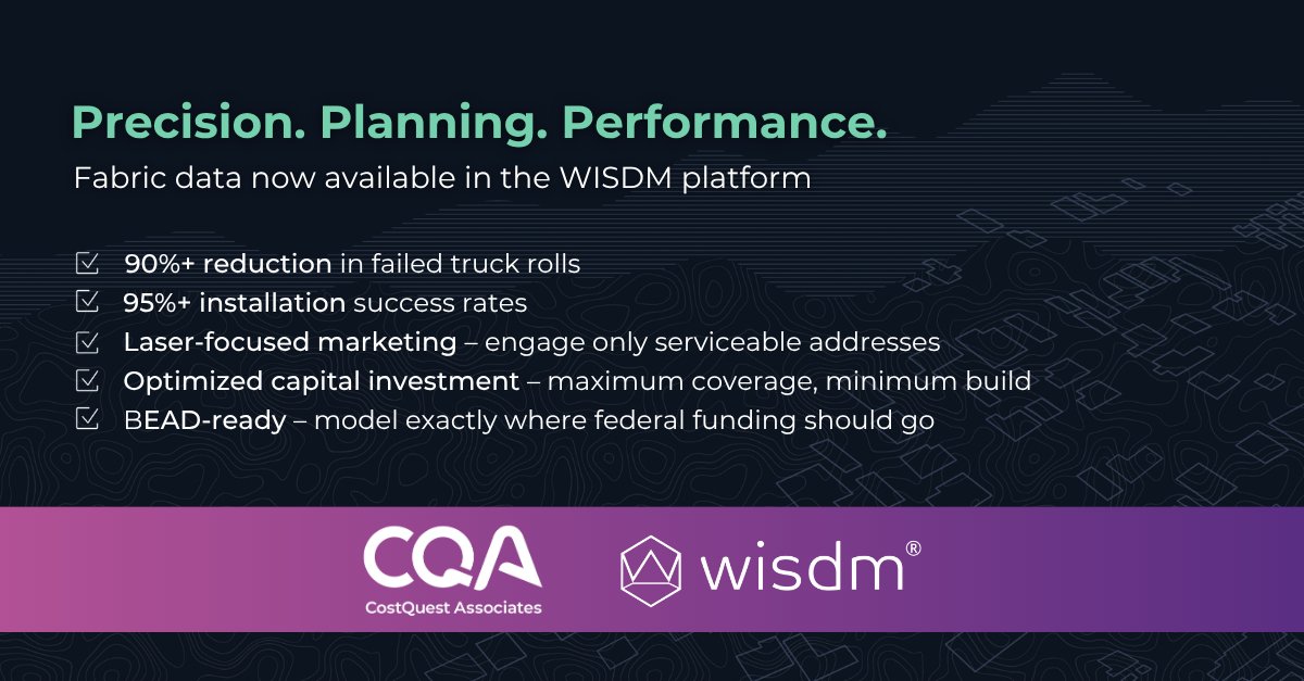
CostQuest Associates and WISDM have partnered, and it's a first for the fixed wireless industry.
Fixed wireless operators have been making critical business decisions – where to build, who to market to, which doors to knock on – with imprecise data.
The result? Wasted capital, failed truck rolls, and missed opportunities to connect communities.
CostQuest's industry-leading Fabric BSL data is now commercially available inside the WISDM platform, giving fixed wireless ISPs address-level precision at every stage of their business: network planning, marketing, sales qualification and installation.
This isn't just about better maps. It's about helping ISPs grow smarter, deploy capital more efficiently, and play a real role in universal connectivity, including directing BEAD funding exactly where it's needed most.
Real-time coverage predictions. Installation success rates well over 95%. The guesswork era for FWA is over.
👉 Learn more at costquest.com | wisdm.ai
Read more about the partnership here: costquest.com/wp-content/upl…
24
In broadband, a lot can happen in one month. Keeping up means knowing what to pay attention to and where to find it.
The latest edition of The Current brings together bite-sized insights on broadband progress, market shifts, company news, and fresh expert perspectives.
Here’s what’s inside our May edition:
🔹 From our desk to yours: CostQuest’s Brian Allenby reflects on the collective fatigueand the very real, often overlooked progress—that has shaped the broadband ecosystem over the past four years, and why the road ahead may be the most consequential chapter yet.
🔹 A “fun size” version of the latest Broadband in America report: A look at the report’s biggest takeaway: fixed wireless providers are entering a new competitive phase, and those who recognize the shift will be best positioned for what comes next. We touched on what the data is telling us and what it means for wireless strategies. costquest.com/resources/arti…
🔹 In case you missed it: James Stegeman on Fiber for Breakfast - CostQuest’s CEO joined Fiber Broadband Association's Gary Bolton to discuss fiber growth, what’s driving it, and the most important competitive shifts happening in U.S. broadband right now. The data reveals the details.
🔹 Fabric Forward 26: Registration is now open for Fabric Forward—returning to Seattle, WA this October. If your team is focused on funding compliance, deployment, or competitive strategy, this is an event you don’t want to miss.
🔹 Joann in the spotlight: We’re celebrating Joann Lawler, a Senior Consultant who spent 12 years at CostQuest, and share a summary of her remarkable five-decade career and lasting impact on modern telecom cost modeling.
🔹 Just for fun: Staff picks to add to your “when I get a break” list.
👇 Subscribe below to ensure you never miss an edition.
mailchi.mp/costquest.com/cos…
31
Apr 28
What does it take to become one of the most formidable telecom cost modeling experts in the country?
For CostQuest Senior Consultant Joann Lawler, it started in 1977 at New Jersey Bell – one of two women in an engineering group of nine – and it never really stopped.
Her career spans nearly five decades, from assistant engineer at New Jersey Bell in 1977 through the seismic shifts of the 1984 AT&T divestiture, the dawn of fiber, the buildout of Verizon Fios, and ultimately to CostQuest, where she arrived in 2014 and quietly transformed what the company could do.
She built cost models estimating billions of dollars in network investment. She rewrote critical components of CostQuest's modeling platform, pushed the team into new lines of business, and mentored the next generation of analysts on technology and methodology that took her decades to master. And she did all of it by simply putting her head down and getting things done.
We're proud to celebrate Joann Lawler's remarkable career. See the full video and link to read here:
costquest.com/resources/arti…
44
Apr 24
The broadband industry is moving faster than most internal playbooks can keep up with. Regulatory rules are shifting, competition is accelerating, and the gap between strategy and execution has never been riskier.
CostQuest's Fabric Forward event is back, and this year’s agenda is crafted to help teams effectively navigate the new road ahead.
Join ISPs, State Broadband Offices, and industry leaders in Seattle for CostQuest's working conference where data, policy shifts, and market intelligence turn into strategies and workflows you can implement immediately to stay on top of changing market dynamics.
✅ Candid regulatory updates & compliance direction
✅ Competitive frameworks built for today's market
✅ Hands-on data & technical workflow guidance
No surface-level insights: just clear data, clear direction, and real outcomes for broadband’s next chapter.
Fabric Forward 2026 | Seattle, WA | October 26 - 29
🔗 Register today, limited spots available → lnkd.in/gHTa6adx
#FabricForward26 #broadband
16
Apr 23
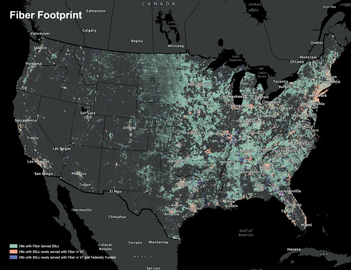
Fiber broadband has officially crossed a major milestone, and the momentum shows no signs of slowing.
Key #BroadbandinAmerica insights:
🔵 Fiber now covers 60% of all served U.S. locations, a 10-percentage-point gain in just 18 months – outpacing every other #broadband technology combined.
🔵 AT&T leads the charge, serving 15.5% of all #fiber BSLs nationwide, while major cable operators now collectively serve over 6 million fiber locations, up from 3.9 million in 2023.
🔵 The provider landscape is expanding rapidly, with 1,561 active fiber providers nationally – including 42 new market entrants and 71 providers that doubled their existing footprint.
🔵 Federal programs are fueling rural deployment, with 29.5% of all rural fiber locations now federally funded – and #BEAD poised to accelerate access even further.
The convergence of ILEC copper-to-fiber upgrades, cable FTTP deployment, and maturing federal funding is creating a compounding effect unlike anything we've seen before.
Explore the latest Broadband in America: Fiber Optic Market Focus report to see where fiber is growing, who is driving it, and what federal investment is making it possible. ⬇️
#fiberbroadbandcoverage
costquest.com/resources/arti…
28
Apr 22
Real stakes and real impacts come with BEAD. CostQuest’s experts, Brian Delidow and Brian Allenby, have each spent significant parts of their careers in the #broadband and telecom space, and they'll both tell you the same thing: what's in front of all of us right now is unlike anything the industry has seen before.
The chance to connect every home and business in this country with internet, to support the ISPs building the infrastructure and the states managing those programs, is something that drives how our entire team operates.
That sense of purpose is what we bring to every partnership, and it's what shapes every solution we build.
In the coming weeks, hear from Brian and Brian as they share their perspectives from working on #BEAD projects so far, discuss the importance of this program, and how we can help in the mission to expand connectivity nationwide.
39
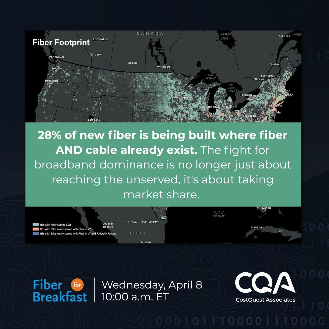
The broadband competition map is being redrawn, and the data tells a story the industry needs to be fully prepared for.
Fiber now covers more than 60% of all served locations in the United States. But here's what's really shaking up the competitive landscape: 28% of new fiber is being built directly into markets already served by both fiber AND cable providers.
With 1,561 active fiber providers nationwide, 42 new market entrants, and 71 providers doubling their existing footprint, competition isn't coming: it's already here. Join us this Wednesday on the Fiber for Breakfast podcast where James Stegeman, president and CEO of CostQuest, sits down with Gary Bolton, president and CEO of the @fiberbroadband Association, to discuss CostQuest’s latest Fabric-based analysis on the market realities broadband stakeholders need to understand as they plan for the future.
If you're planning network builds, investments, marketing strategies, or tracking competitive dynamics, this is a conversation you won’t want to miss: lnkd.in/gbqGAW7x
33
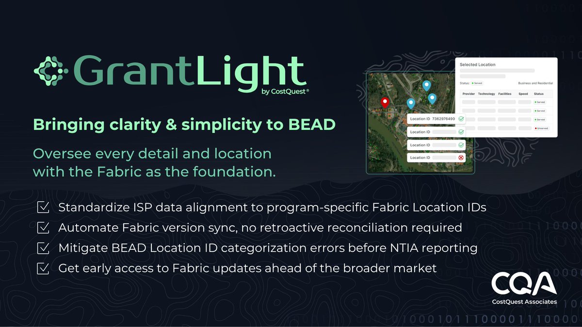
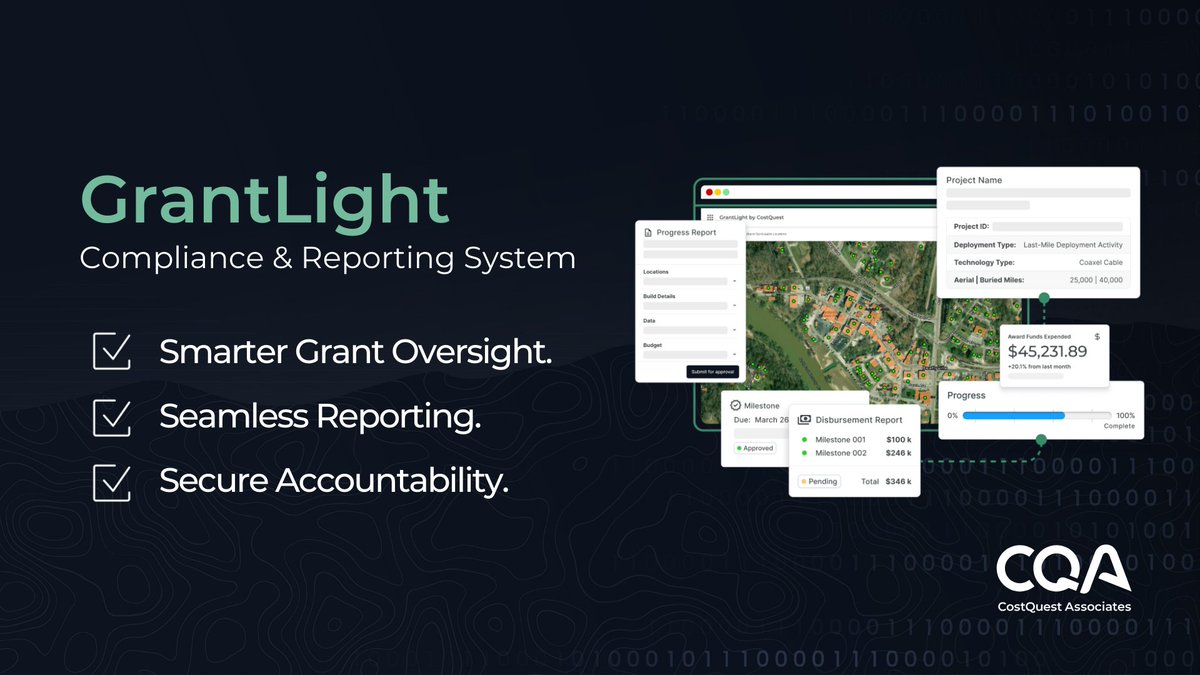
State Broadband Offices have a lot on their plates: getting BEAD awards to subgrantees, transitioning oversight programs to new compliance standards, and tracking potential updates on program guidance.
One standard BEAD introduces is a granular location tracking model using FCC Fabric Location IDs detailed semi-annual reporting requirements.
To get ahead, states are starting to think through:
🔹How can we start setting up our compliance process and leave room for modifications if/when new program guidance comes in?
🔹 How can we facilitate matching subgrantee’s location data to Fabric IDs?
🔹 How can we set up processes to keep our #BEAD data current with FCC BDC and Fabric biannual updates?
🔹 What standards can we put in place early to help prevent reporting challenges and delays?
The upside to BEAD’s oversight requirements is unprecedented, location-level visibility into connectivity progress, and a clearer way to demonstrate the impact and stewardship of public funds.
CostQuest and the GrantLight System are helping states transition their compliance programs into a seamless Fabric-native workflow and bring some clarity and simplicity into the next phase.
Explore common set up strategies and how it could look for your program – get in touch here: lnkd.in/gJNHD8YJ
Or see more details: bit.ly/grantlight
30
The U.S. fixed broadband market is entering a new era of competition – and the battle for subscribers is heating up.🔌
Key #FixedBroadband Insights:
🔵 Approximately 28% of new fiber is now being built to homes already served by both fiber and cable providers, signaling intensifying competition in urban markets.
🔵 Smaller providers are becoming aggressive overbuilders, with ~40% of their new builds targeting second-fiber markets – up from 18% in 2022.
🔵 Large cable operators maintain national penetration rates above 50%, yet are experiencing subscriber losses despite continued network expansion.
🔵 Licensed fixed wireless remains a credible alternative in suburban and rural markets, while unlicensed fixed wireless shrinks where wireline overbuilds occur.
As BEAD funding rolls out and fiber pushes deeper into legacy territories, the key question is no longer just where service exists – but where competitive pressure and ROI will shift next.
Explore the latest Broadband in America: Fixed Broadband Competition Focus report to understand how America's broadband landscape is transforming. ⬇️
costquest.com/resources/arti…
#BroadbandinAmerica #broadband #fiber #broadbandcompetition
28
Jan 29
The 60-day clock is ticking. For State Broadband Offices, an estimated $21 billion in remaining #BEAD funds is about to come into focus, and preparation starts now.
Here's the reality: NTIA's forthcoming policy notice will outline how states can access remaining BEAD funding, and how state AI laws may affect eligibility. SBOs already have plenty on their plates – Final Proposal approvals, award negotiations, project kickoffs, EHP compliance – but the magnitude of these funds demands attention today.
The difference between states that are ready and those that scramble? Asking the right questions early.
Questions like:
🔷 Is my state eligible? Identify existing AI-related statutes, regulations, and pending bills now, clarifying legislative intent early can prevent innocuous laws from being misidentified as "onerous."
🔷 Do our priorities align with federal goals? Stress test non-deployment priorities through two lenses: advancing US AI leadership and delivering clear, non-duplicative value to taxpayers.
🔷 Can we move quickly when the window opens? Think through what an "Initial Proposal Volume III-type" submission would require: needs assessment, partner buy-in, budget development, permitting acceleration concepts.
Remaining BEAD funds don't have to catch your state off guard. With deliberate planning now, your program can be positioned to respond quickly and credibly.
The CQI Team – CostQuest, #QuadraPartners and @itgcomm – brings funding strategy, program design, data, and policy experience to help states navigate what comes next.
Learn more about preparing for the remaining BEAD funding opportunity in this featured CQI blog written by Brian Mitchell, Principal Consultant at ITG, with contributions from CQI Team members: costquest.info/bead-early-co…
ALT $21 billion. 60 days. Are you ready? CQI Team featured blog: Remaining BEAD Funds and the 60-day Clock: Early Considerations for States & Partners
28
Jan 14
One point of friction State Broadband Offices (SBOs) often encounter in the post-award grant oversight process: widespread evidence gaps in subgrantee milestone submissions.
This is usually a shared understanding issue where there is misalignment on what a “complete” milestone submission package includes.
Gaps in submissions often present themselves when SBOs receive:
🔹 Evidence photos with missing geotags
🔹 Unlabeled test results
🔹 Or as-built drawings that don’t reconcile with the BSL list
The best way to prevent gaps is to make submission standards visible early:
🔹 Provide a “perfect milestone submission package” examples
🔹 Host a how-to submission clinic (with a first-round grace period)
🔹 Share the top 2 recurring issues and solutions across the reporting lifecycle
Clear standards and preventive support upfront = fewer rejections, faster payments, and less rework and delay
Head to the latest CQI Team blog for insights on preventing common post-award compliance challenges and delays before they happen: bit.ly/bsl-mismatches
22
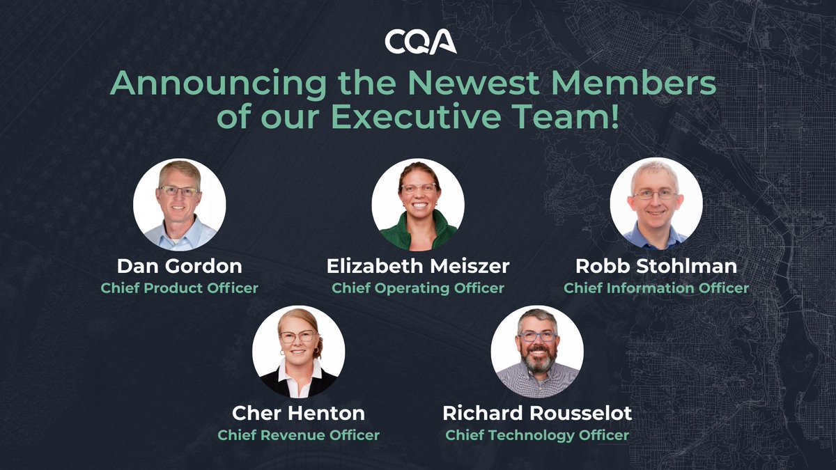
🎉 As we celebrate 25 years of CostQuest, we’re excited to share the next chapter in our growth. What began as four consultants working together to solve complex challenges for commercial telecommunications companies has now grown into a team of more than 65 employee-owners.
This last year, our team turned ambition into momentum – and momentum into outcomes. We expanded how customers and partners access our data – by launching new products, strengthening APIs, and advancing platforms like TrueVerra.io. We’ve supported evolving federal use cases, from HUBB and Universal Service Fund filings to BEAD award selection, and delivered intuitive dashboards that bring broadband availability and market trends into sharper focus.
🌟To scale this impact into the next quarter century, we’re proud to announce the newest members of our executive team:
Dan Gordon, Chief Product Officer
Cher Rowland Henton, Chief Revenue Officer
Elizabeth Meiszer, Chief Operating Officer
Richard Rousselot, Chief Technology Officer
Robb Stohlman, Chief Information Officer
This next generation of executives brings deep operational, technical, and commercial expertise, positioning us to accelerate innovation, strengthen customer outcomes, and be good stewards that solve real complex challenges and make a meaningful difference across communities.
We’re grateful to our employees, partners, and customers for the trust and collaboration that make this next step possible – and we’re energized for what’s ahead in 2026 and beyond.
Read a note from our CEO and co-founder, Jim Stegeman, to learn more about the next generation of CostQuest leadership: costquest.info/49LQri8
22
Avoiding post-award compliance pitfalls starts well before anything goes wrong.
One of the biggest post-award challenges for BEAD will be tracking and keeping Broadband Serviceable Location (BSL) data from the #Fabric in sync as projects progress during the multi-year network build-out period. Even when every location has a location_id, things can drift over time:
🔷 Fabric is updated biannually, and versions evolve – location_ids added, retired or reclassified
🔷 Field conditions change
🔷 Evidence references addresses or internal work order numbers instead of location IDs
🔷 Reviewers and subgrantees work from different Fabric versions (snapshots in time)
🔷 New construction, long driveways, etc.
The solution is better alignment: automated Fabric feeds help capture BSL changes early, flag impacts to active projects, and keep SBOs, reviewers, and subgrantees working from the same source of truth.
Head to the latest CQI blog to learn which issues show up post-award and how simple data practices can prevent compliance friction before it turns into delay.
cqiteam.com/blog/red-flags-f…
#BEAD #Broadband
31
New year, renewed focus. Looking forward to continuing the work and partnerships that move progress forward.

24
30 Dec 2025
Not all broadband mapping data is created equally! The difference isn’t just resolution: it’s the type of information available.
Here’s how the two views compare:
➡️ Hex-level data summarizes an area
➡️ Location-level data describes individual structures
At the hex level, you typically see:
🔹 A geographic boundary
🔹 An aggregated count of locations
🔹 High-level coverage or eligibility indicators
What’s missing?
Hex-level views don’t show where individual structures are located, what type of buildings they are, or how many units exist at each location. Every structure inside the hex is reduced to a single summary statistic.
Location-level data fills in those gaps.
With location-level mapping from the Broadband Fabric, each Broadband Serviceable Location (BSL) is represented as its own record, complete with precise coordinates and structure attributes.
What you gain at the location level:
✅ Exact latitude and longitude for each structure
✅ Precise rooftop placement
✅ Individual addresses tied to Location IDs
✅ Building type and land use classification
✅ Unit counts per structure
Click here to easily capture coordinate-level location data: costquest.info/4p13xws

28
19 Dec 2025
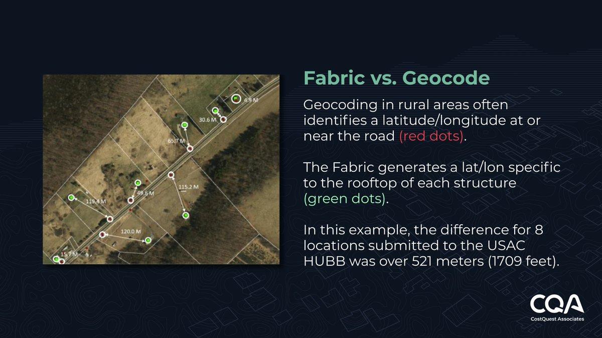
**Planning to a general area on a map vs. planning to an actual building?**
There can be a big cost and time differential when planning networks to general areas versus the exact coordinates of location structures.
Here's what we commonly see:
➡️ A network planner draws up the network design
➡️ The finance team approves the build cost
➡️ Construction starts
➡️ Reality hits: the planned drop point ends up 40 yards from the actual building
Why? When network designs rely on incorrect coordinates of location structures, planned network drop points often land along road centerlines or parcel centroids instead of the actual customer structure.
The fix? Use a validated database of exact structure coordinates.
The results:
✅ Your network plans reflect real drop distances
✅ More accurate build plans and cost models
✅ Fewer construction change orders and field corrections
✅ Change orders drop dramatically
✅ Faster, more predictable service delivery
Click here to easily capture coordinate-level location data from the Broadband Fabric: trueverra.io/broadband-fabri…
19
18 Dec 2025
‼️For the first time in a federal broadband grant program, compliance liability sits squarely with State Broadband Offices! The #BEAD program shifts extraordinary new compliance liability and complexity to State Broadband Offices. That's not just a policy shift – it changes how states must think about deploying and managing BEAD funding.
In addition to managing new and existing subgrantees, ensuring the financial sustainability of dozens of projects, states are now responsible for tracking and reporting progress across tens or hundreds of thousands of locations. All this while ensuring stakeholders are informed and brought along for the journey.
👉 CostQuest's GrantLight system is purpose-built to bridge that gap. It's the only compliance platform with a Fabric-native data architecture, designed to help SBOs:
- Identify risks before they become problems
- Streamline milestone tracking and fund disbursement
- Simplify NTIA reporting with validated, audit-ready data
- Communicate progress to stakeholders with real-time dashboards
- Focus on outcomes—not paperwork
- Built by the team that knows this terrain
🌐Developed by CostQuest Associates (architects of the FCC's Location Fabric and Connect America Cost Models), alongside our expert partners #Quadra Partners and #ITG, as well as direct input from state broadband office leaders.
Learn more at: costquest.info/45egTOP
19