
AMS CCM, CBM, NWA. Retired WKRN Met, Florida State/Tulane grad, Jesuit H.S. '72. I believe in Jesus, but don’t think other religions are necessarily wrong.
Joined January 2011
- Tweets 41,143
- Following 349
- Followers 9,022
- Likes 4,190
14,539 Photos and videos


Special Weather Statement for Coffee & Grundy until 4:15 PM 6/14. Wind gusts up to 40 mph are possible. Radar indicated a strong thunderstorm moving E. Secure loose items and seek shelter indoors if outdoors.
63
Special Weather Statement for White, Cumberland, Warren, Van Buren until 4:15 PM 6/14. Strong storms may bring wind gusts up to 40 mph and torrential rain. Secure loose items, avoid flooded roads, and seek shelter indoors if outdoors.
62
Special Weather Statement for Jackson, Moore, Franklin until 4:00 PM 6/14. Wind gusts up to 50 mph may knock down tree limbs and blow unsecured objects. Torrential rain could cause localized flooding. Seek shelter indoors; don’t drive through flooded roads.
78
Special Weather Statement for Coffee & Grundy until 3:30 PM 6/14. Strong thunderstorm may bring wind gusts up to 40 mph. Radar indicated gusty winds could knock down tree limbs and blow unsecured objects. If outdoors, seek shelter inside.
1
83
Storms done in Lawrence Co. Latest storm reports from Lawrence EMA: Tree & powerlines down on residence. Powerlines live, 3mi east L'burg.
Update on Bluff Road -- Multiple power & telephone lines down.
Tree blocking 305 Gibbs Road near Gandy Community (Central Lawrence County).
124
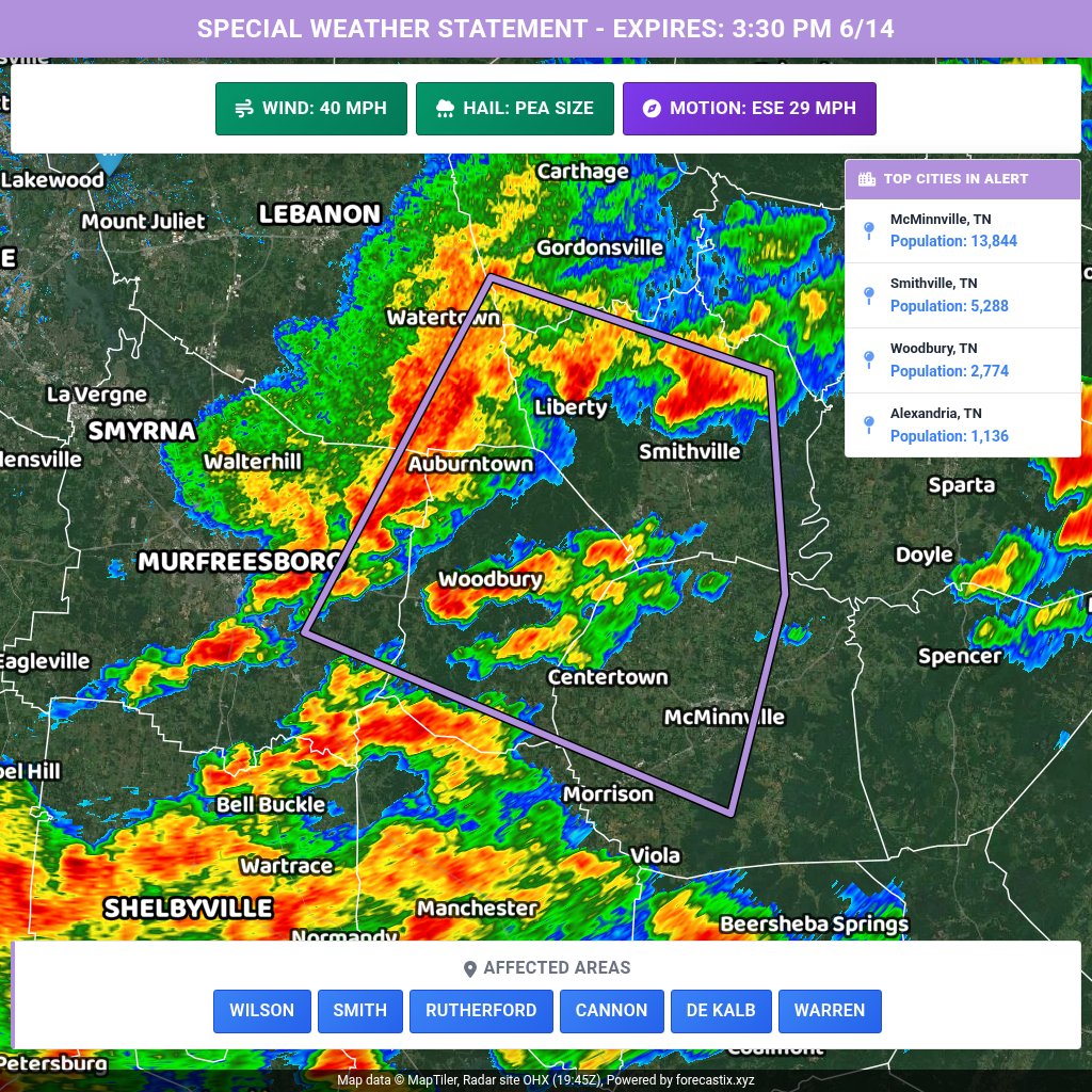
Special Weather Statement for Wilson, Smith, Rutherford, Cannon, De Kalb, Warren until 3:30 PM 6/14. Wind gusts up to 40 mph. Torrential rain may cause localized flooding. If outdoors, seek shelter indoors; don’t drive through flooded roads.
91
Flood Advisory for Bedford, Coffee, and Grundy, TN until 6:00 PM CDT. Minor flooding in low-lying/poor drainage areas with overflowing and ponding. Heavy rain has occurred; more 0.5–1" possible. Turn around, don’t drown—avoid flooded roads.
91
Severe Thunderstorm Warning for Franklin, TN & Others until 3:30 PM 6/14. 60 mph wind gusts and 0.75 in hail possible. Radar-indicated storm near Fayetteville moving E at 40 mph. Move to an interior room on the lowest floor.
85
Radar be at 5100 feet above the surface showing when’s an excessive 60 mph. @NWSNashville says winds are sinking to the surface. Lawrence County EMA reporting powerlines down 3 miles east of Lawrenceburg.
1
1
185
That’s “winds in excess of 60 mph”. Should never trust voice recognition!
1
104
Special Weather Statement for Pickett, Overton, and Fentress until 3:15 PM 6/14. Wind gusts up to 40 mph. Torrential rain may cause localized flooding. Seek shelter indoors; don’t drive through flooded roads.
97
Flood Advisory for Bedford, Giles, and Marshall, TN until 5:45 PM CDT. Urban and small stream flooding expected from excessive rainfall. Minor flooding/poor drainage overflow possible. Turn around, don’t drown—avoid flooded roads.
95
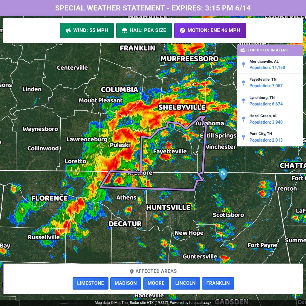
Special Weather Statement for Limestone, Madison, Moore, Lincoln, Franklin until 3:15 PM 6/14. Wind gusts 50-55 mph possible. Gusty winds may knock down tree limbs and blow unsecured objects. If outdoors, seek shelter inside a building.
87
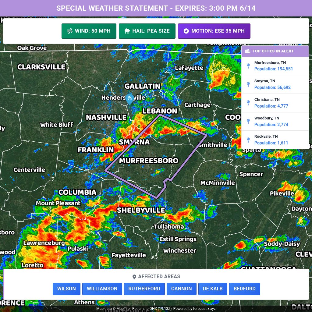
Special Weather Statement for Wilson, Williamson, Rutherford, Cannon, De Kalb, Bedford until 3:00 PM 6/14. Strong storms may bring wind gusts up to 50 mph, knocking down tree limbs and blowing unsecured objects. If outdoors, seek shelter indoors.
99
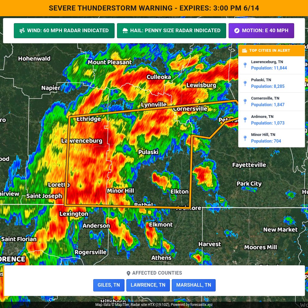
Severe Thunderstorm Warning for Giles, TN, Lawrence, TN & Marshall, TN until 3:00 PM CDT. 60 mph wind gusts and 0.75 in hail possible. Radar indicated. Move to an interior room on the lowest floor; avoid windows.
93
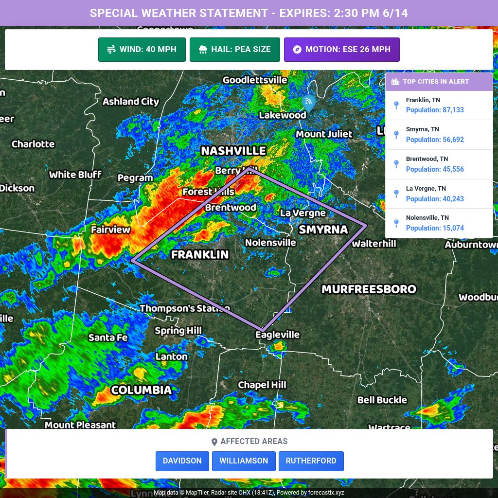
Special Weather Statement for Davidson, Williamson, Rutherford until 2:30 PM 6/14. Wind gusts up to 40 mph may knock down tree limbs and blow unsecured objects. If outdoors, seek shelter inside a building.
2
143
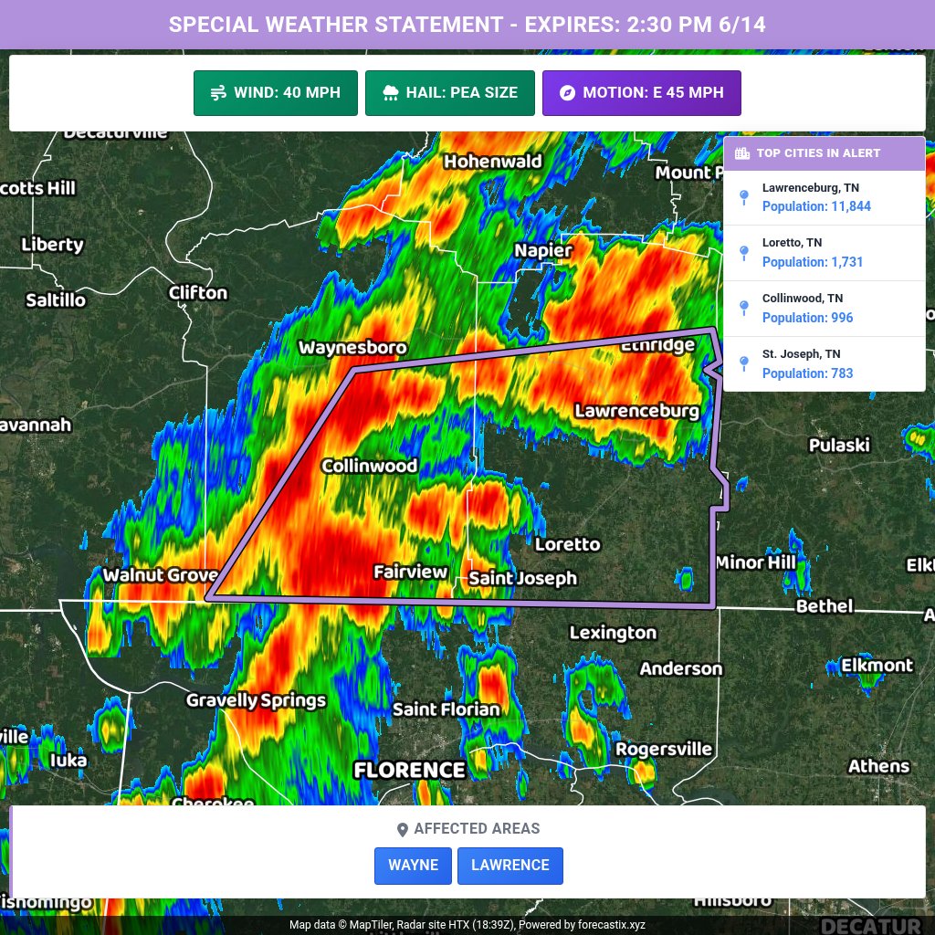
Special Weather Statement for Wayne & Lawrence until 2:30 PM 6/14. Wind gusts up to 40 mph and pea-size hail possible. Radar-indicated storm may knock down tree limbs and blow unsecured objects. If outdoors, seek shelter indoors.
1
121
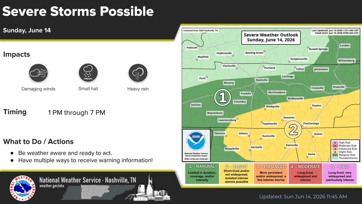
UPDATE: SPC has pushed the level 1 risk west and added a level 2 risk for damaging winds: @NWSNashville: “We have just enough wind shear to interact with building instability to get a few strong - severe storms going ahead of the front this afternoon.”
1
181
After an off & on wet Sunday, we can look forward to lower humidity Monday & Tuesday! As we head into summer, we won’t get to enjoy that very often.


5
225
Flash Flood Warning for Giles, TN & Others until 11:30 PM CDT. Flash flooding from heavy thunderstorms is ongoing/expected, incl. Richland Creek basin. Flooding of creeks, streets, underpasses and poor drainage areas. Turn around, don’t drown.

173