
Official account of the Delaware Emergency Management Agency (DEMA): lead state agency for emergency preparedness, training, response, recovery, and mitigation.
Joined December 2008
- Tweets 7,315
- Following 286
- Followers 20,820
- Likes 1,254
1,193 Photos and videos


NWS Alert> Severe Thunderstorm Watch is in effect in Kent, New Castle and Sussex Counties until 1 AM #dewx simpleweatheralert.com/cgi-b…
1
65
DEMA ALERT: Severe Thunderstorm Watch for Kent, New Castle, and Sussex County in DE until 1:00am. Go to weather.gov/phi for more. #dewx
75
NWS Alert> Coastal Flood Advisory in effect from Sunday evening in Kent, Inland Sussex and Delaware Beaches #dewx simpleweatheralert.com/cgi-b…
1
288
NWS Alert> Coastal Flood Advisory in effect from Saturday evening in In Delaware, Kent, Inland Sussex and Delaware Beaches. In New Jersey, Cumberland, Atlantic, Cape May and Atlantic Coastal Cape May #dewx simpleweatheralert.com/cgi-b…
250
NWS Alert> Severe Thunderstorm Near Millville or 10 Miles N of Ocean City Moving E At 20 MPH. 60 MPH Wind Gusts. Damage to Roofs, Siding, Trees & Power Lines is Possible. Locations Impacted Include Millville, Ocean View & S Bethany. #dewx simpleweatheralert.com/cgi-b…
2
1
289
NWS Alert> Severe Thunderstorm Near Millville or 14 Miles SE of Georgetown Moving E At 20 MPH. 60 MPH Wind Gusts. Damage to Roofs, Siding, Trees & Power Lines is Possible. Locations Impacted Include Dagsboro, Millville, Long Neck, Ocean... #dewx simpleweatheralert.com/cgi-b…
1
292
NWS Alert> Severe Thunderstorm Warning is in effect in Sussex County until 11 PM #dewx simpleweatheralert.com/cgi-b…
1
273
NWS Alert> Severe Thunderstorm Over Dagsboro or 11 Miles SE of Georgetown Moving E At 20 MPH. 60 MPH Wind Gusts. Damage to Roofs, Siding, Trees & Power Lines is Possible. Locations Impacted Include Millsboro, Dagsboro, Millville, Long... #dewx simpleweatheralert.com/cgi-b…
1
1
253
DEMA ALERT: Severe Thunderstorm Warning for Sussex County in DE until 11:00pm. Go to weather.gov/phi for more. #dewx
1
281
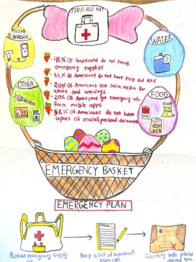
Join us at the Emergency Preparedness Fair on June 16th! The fair will be held at Delaware Technical Community College's Georgetown Campus from 5:30 pm - 7:30 pm.
To rsvp, please scan the QR code or visit mcbride.house.gov/about/even…
3
278
Temperatures continue to be on the rise today along with high humidity.
Changing some small habits will go a long way. Stay hydrated, wear loose-fitting, lightweight clothing, and apply sunscreen at least 20-30 minutes before any sun exposure.


1
1
203
DEMA Director A.J. Schall pictured here with local leaders at the 2026 Gulf and Atlantic Hurricane Summit.

This week, FEMA officials joined state and local leaders at the 2026 Gulf and Atlantic Hurricane Summit to strengthen coordination and readiness at the start of hurricane season.
🔗 fema.gov/press-release/20260…
🧵⬇️


2
336
NWS Alert> Severe Thunderstorm Watch is in effect in Kent, New Castle and Sussex Counties until Midnight #dewx simpleweatheralert.com/cgi-b…
1
2
288
DEMA ALERT: Severe Thunderstorm Watch for Kent, New Castle, and Sussex County in DE until 12:00am. Go to weather.gov/phi for more. #dewx
2
1
313
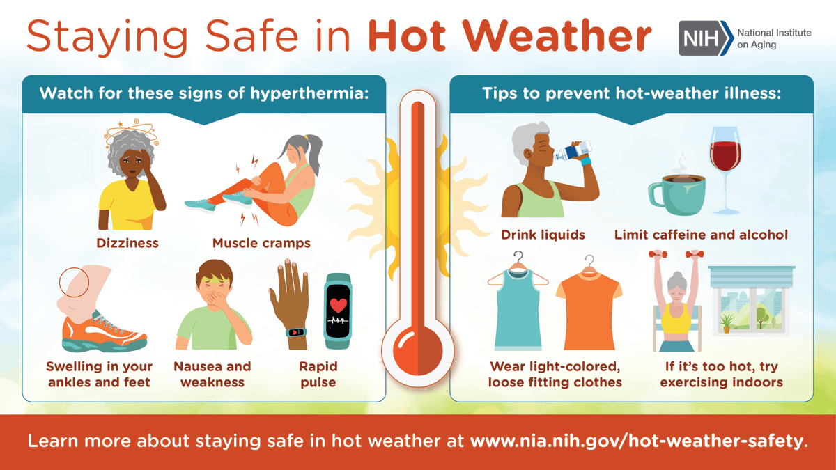
With high temperatures in the low to mid 90s and high humidity in the region over the next couple of days, now is as good a time as ever to understand the signs of heat illness.
Hydrate, wear lightweight clothing, and take frequent breaks if you are working outside in the today.
1
245
Delaware Emergency Management Agency (DEMA) retweeted

Jun 11
⚠️⛈️ Scattered severe thunderstorms are possible today. Storms could produce damaging wind gusts and brief heavy downpours, as well as hail up to quarter size. Main timing will be between 5-11 PM. Remain alert for changing conditions later today! #PAwx #NJwx #DEwx #MDwx
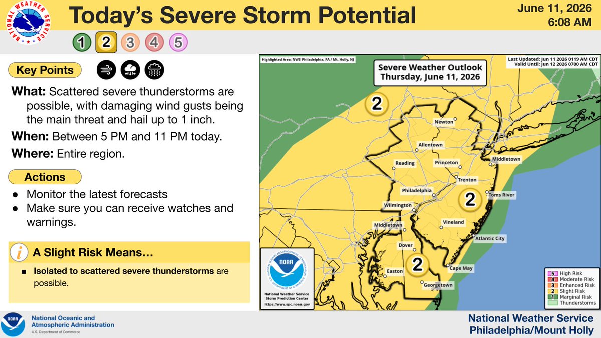
ALT There is a slight risk of severe thunderstorms across the region this afternoon and evening.
6
30
94
9,127
Delaware Emergency Management Agency (DEMA) retweeted
Jun 11
⚠️🥵⛈️ The hottest heat indices so far this year are expected today, topping out near 100° this afternoon in most areas. Near record breaking highs in the low to mid 90s. A Heat Advisory remains in effect through Friday for portions of the area. #PAwx #NJwx #DEwx #MDwx

ALT Forecast maximum heat indices for this afternoon.
6
69
222
60,437
Delaware Emergency Management Agency (DEMA) retweeted
Jun 10
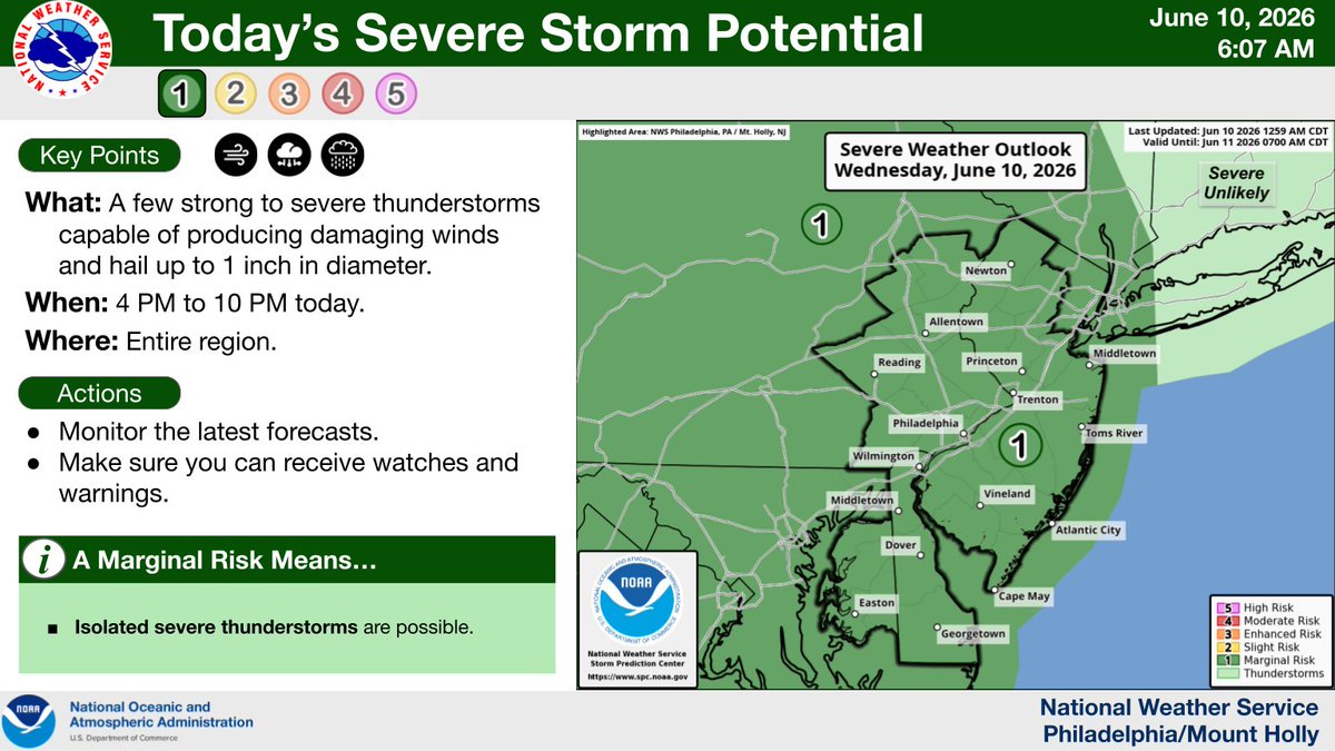
Humidity will increase substantially today despite highs mid 80s. A few morning showers possible, then scattered storms are forecast to develop this afternoon (4-10 PM). A few storms could be severe, with locally damaging winds and brief downpours. #PAwx #NJwx #DEwx #MDwx
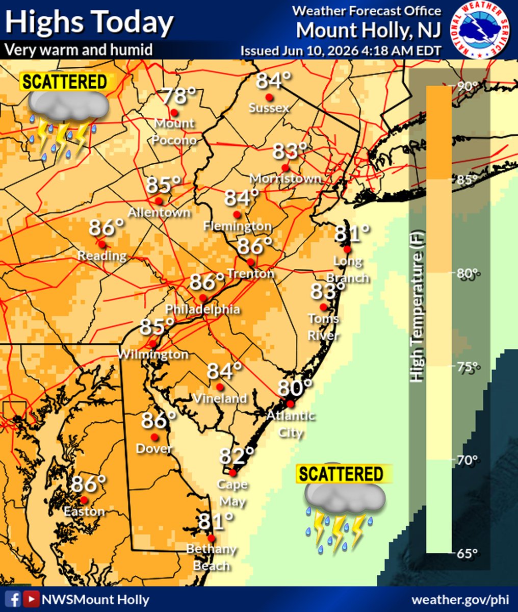
ALT Forecast high temperatures for today.
1
13
52
7,166
NWS Alert> Heat Advisory in effect from Thursday morning in New Castle County #dewx simpleweatheralert.com/cgi-b…
1
210