
This is Donegal's first and top weather channel for all your weather forecast and weather updates we cover all of Donegal, and Ireland and cover Northern lights
Joined January 2012
- Tweets 24,167
- Following 1,636
- Followers 12,056
- Likes 2,157
4,650 Photos and videos
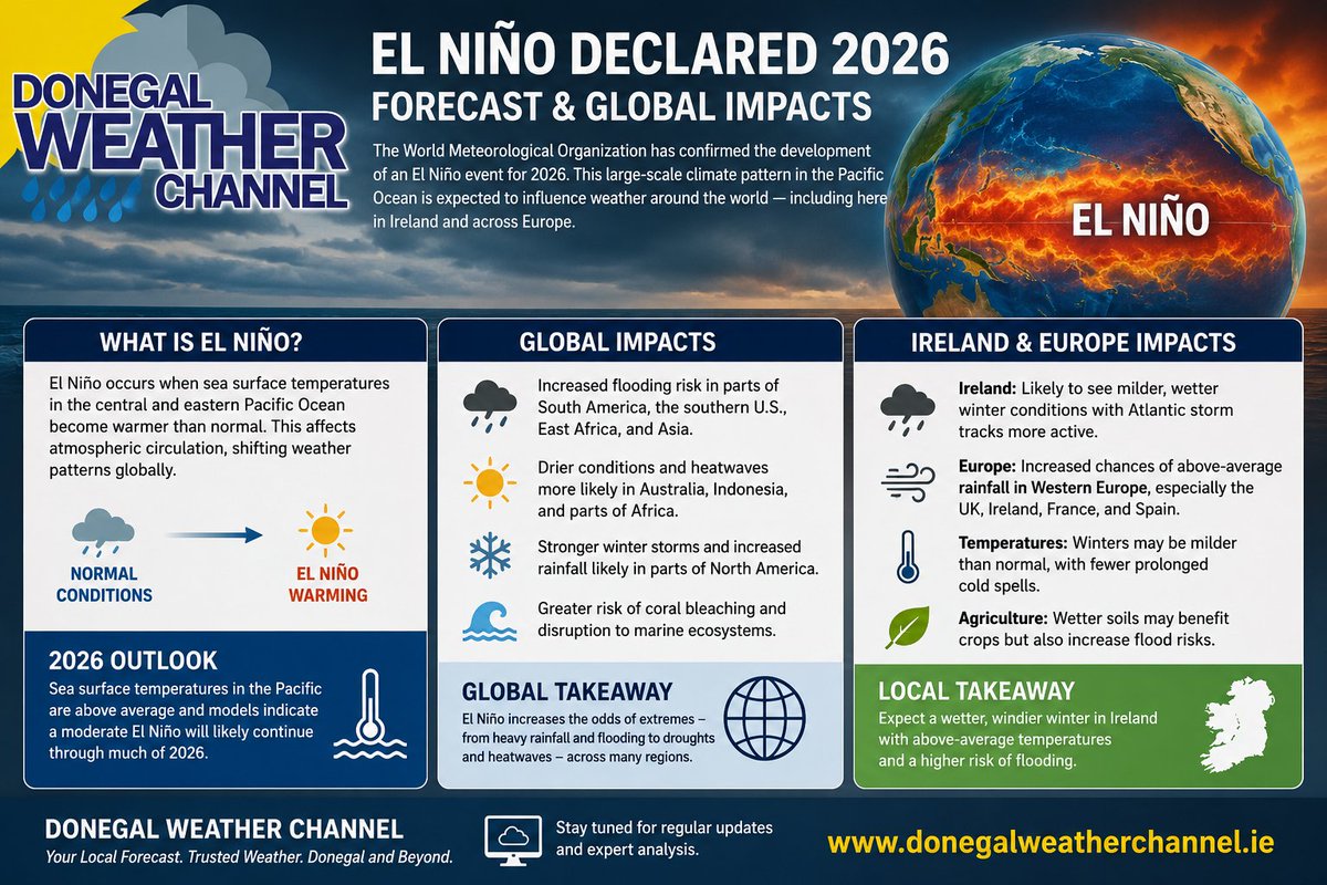


☀️☔ EL NIÑO 2026: WHAT IT COULD MEAN FOR THE WORLD, EUROPE & IRELAND🌡️⚠️
Climate models are increasingly indicating the development of an El Niño pattern during 2026, a large-scale ocean-atmosphere phenomenon that occurs when sea surface temperatures in the central and eastern tropical Pacific become warmer than average.
El Niño can significantly influence global weather patterns, often leading to more extreme and contrasting conditions around the world.
**Global Impacts**
Across the globe, El Niño may increase the likelihood of:
• Flooding and heavier rainfall across parts of the Americas and East Africa.
• Hotter and drier conditions in regions such as Australia, Indonesia, and parts of southern Africa.
• Warmer global temperatures, with an increased risk of heatwaves in some regions.
• Changes to storm tracks, affecting seasonal weather patterns and tropical cyclone activity.
**Europe Outlook**
For Europe, El Niño’s influence is often indirect but can still affect large-scale atmospheric circulation patterns.
Potential impacts may include:
• Milder than average winter temperatures in parts of western and northern Europe.
• Increased Atlantic storm activity, especially later in autumn and winter.
• Above-average rainfall risk for western regions, while southern Europe can sometimes experience more unsettled contrasts.
**Ireland & Donegal Outlook**
For Ireland, including Donegal, El Niño may favour:
🌧️ Wetter and windier conditions, particularly during autumn and winter.
🌡️ Slightly milder temperatures, reducing the risk of prolonged cold spells.
🌊 An increased flooding risk due to stronger Atlantic systems and prolonged rainfall episodes.
💨 More active storm tracks, though local weather will still depend heavily on Atlantic and North Atlantic Oscillation patterns.
**Important Note**
While El Niño can influence long-range trends, it does not determine day-to-day weather in Ireland. Forecast confidence decreases the further ahead we look, and regional outcomes may still vary.
Stay tuned for further updates as new seasonal forecast data becomes available.
Kenneth from the Donegal Weather Channel
🌐 donegalweatherchannel.ie
#weather #ireland #fblifestyle #europe #ElNiño #world
2
6
1,469
Good morning! A few showers and patches of drizzle are expected this morning, but don't worry—some brighter and sunnier spells will develop. By early afternoon, the isolated showers will clear, leading to drier weather overall, with a mix of clouds and sunshine. Expect temperatures to range from 13°C to 20°C.
Tonight should be dry with clear spells for most areas. However, northern parts of Ulster, particularly North Donegal, Derry, and Antrim, might still see a few showers.
Tomorrow morning may bring a few more showers, but drier conditions are on the way with nice bright and sunny spells, although there will be a bit more cloud in the north. There's a small risk of one or two isolated showers in Donegal. Temperatures will be warmer, ranging from 14°C to 23°C, with the southern half of Ireland experiencing the warmest weather.
Looking ahead to Sunday, it looks to be a dry day with some clouds in the morning. However, bright and hazy sunshine should develop later in the morning and into the afternoon. Temperatures will range from 16°C to 24°C, with the coolest conditions along the eastern coastal areas.
Kenneth from the Donegal Weather Channel
#weather #ireland #fblifestyle #temperature #warm #dry #weekend

14
1,099
Drier conditions are forecast for the game in Ballybofey on Saturday with @officialdonegal vs @OfficialCorkGAA
There will be a mix of cloud and sunny spells with moderate westerly breeze. Temperatures will range between 14C to 17C.
#weather #ireland #Donegal #gaa #cork #Forecast #football
Kenneth from the Donegal Weather Channel
3
622
WARMER THIS WEEKEND ACROSS IRELAND AND DRIER
This weekend, we can expect a warm-up and drier conditions across Ireland as warmer air moves in.
After some rain on Friday morning, drier conditions are likely for most areas in the afternoon and evening, staying mostly dry at least until next Tuesday. However, there's a bit of uncertainty as we could see a return to unsettled weather for a few days before drier and warmer conditions potentially return.
On Saturday, the warmest temperatures will likely be in the Southern and Eastern regions, ranging from 20°C to 24°C, while the west and north will see temperatures between 18°C and 21°C. The day is set to be dry with a mix of sunny spells and clouds.
As we transition to Sunday, temperatures are projected to be in the lower 20s for much of Ireland, with the northwest and west appearing to be the warmest spots, possibly reaching between 23°C and 26°C, while the rest of the country could see 20°C to 24°C. The ECMWF model suggests temperatures ranging from 18°C to 23°C, indicating slight variations among the forecasts which should clarify in the next 24 to 48 hours.
Monday looks to carry on the trend with another dry day, keeping temperatures between 18°C and 23°C across the nation.
Models hint at a warm spell lingering into next week, but the drier weather past Tuesday remains uncertain. Currently, Tuesday and Wednesday temperatures could stay in the high teens to low 20s, accompanied by some rain.
There are indications that this warm spell may give way to some unsettled conditions midweek, but warmer and drier weather may return by next weekend, just in time for the Donegal Rally.
I’ll keep an eye on this over the coming days!
Kenneth from the Donegal Weather Channel
☕You can also support my updates by buying me a coffee. By buying a coffee you are helping secure the future of the page which helps in the maintenance and running costs 👉 buymeacoffee.com/donegalweat…
#weather #ireland #fblifestyle #rain #temperature #sunny #highpressure #europe
30
2,969
Heavy showers throughout Ireland this morning with some hail and isolated thunderstorms, showers will continue into the afternoon and evening with the ongoing risk of some isolated thunderstorms, hail and spot flooding.
Track these thunderstorms here donegalweatherchannel.ie/liv…
#weather #ireland #fblifestyle #hail #thunderstorm #rain
3
740
Heavy showers developing this afternoon with some thunderstorms possible in the west, northwest and north with some hail and lightning.
Showers will move in the direction to the northeast.
Track these thunderstorms here as the develop donegalweatherchannel.ie/liv…
#weather #ireland #fblifestyle #lightning #rain #thunderstorm #thunder
6
983
🌡️ TURNING WARMER FROM THE WEEKEND 🌡️
Conditions are looking promising as we head into the weekend, with temperatures expected to rise into the low 20s for many areas. The attached chart illustrates the upper air temperatures across Ireland for the weekend and early next week. Notably, we'll see very warm upper air temperatures on Sunday into Monday, which could push surface air temperatures into the mid to high 20s by early next week. The GFS and UKMO models predict particularly warm conditions, while the ECMWF is also showing warmth but not as extreme as the other two.
The big question is how long this warm air will stick around. Current indications suggest it could last at least until mid-week. Additionally, we should be on the lookout for thunderstorms, as the warm air may trigger instability leading to possible thunderstorms.
I'll keep you updated throughout the week as more clarity emerges!
Kenneth from the Donegal Weather Channel
☕You can also support my updates by buying me a coffee. By buying a coffee you are helping secure the future of the page which helps in the maintenance and running costs 👉 buymeacoffee.com/donegalweat…
#weather #ireland #fblifestyle #warm #temperature #sunny #uk #europe
2
33
3,146
THUNDERSTORM RISK
Monday 8th June 2026
🟡 MODERATE RISK
📍 Ulster, Connacht, North Leinster.
Heavy showers are expected with a risk of thunderstorm activity particularly for Ulster, Connacht and north Leinster during the afternoon and easing into the evening . Showers will start to develop widely later this morning moving northeastwards in direction . During afternoon some heavy showers and thunderstorms are likely to develop, bringing moderate lightning strikes, potential spot flooding, small hail with the potential for some funnel clouds. Across the northwest high rainfall totals will occur from these heavy showers and thunderstorms. Between 20mm and 30mm possible in a short period.
🟢 LOW RISK
📍 Rest of Leinster and Munster
These areas have a low risk of thunderstorm activity, although heavy showers may still occur. A few lightning strikes are possible, especially near the boundary of the moderate risk zone.
⌚ Forecast valid from 11:00 hrs Monday 8th June 2026 to 20:00 hrs Monday 8th June 2026.
The Donegal Weather Channel will be issuing thunderstorm risk zones due to the anticipated thunderstorms over the summer months, which can be quite disruptive. Risk maps provide better guidance than warning maps, and I hope you find the new graphics helpful!
☕You can also support my updates by buying me a coffee. By buying a coffee you are helping secure the future of the page which helps in the maintenance and running costs 👉 buymeacoffee.com/donegalweat…
Kenneth from the Donegal Weather Channel
#weather #ireland #fblifestyle #thunderstorm #rain #thunder #lightning
1
8
1,013
🌡️ LOOKING MORE LIKELY TO TURN VERY WARM AGAIN NEXT WEEKEND🌡️
Temperatures are looking increasingly likely to warm up next weekend. There’s good model agreement, especially from the ECMWF and GFS models, indicating temperatures might reach the low 20s by Friday and move into the mid 20s over the weekend. Looking ahead to the following week, temperatures could continue to rise, possibly reaching the high 20s and even hitting the 30s.
I'll keep an eye on this over the next few days and provide updates as things develop.
Kenneth from the Donegal Weather Channel
☕You can also support my updates by buying me a coffee. By buying a coffee you are helping secure the future of the page which helps in the maintenance and running costs 👉 buymeacoffee.com/donegalweat…
#weather #ireland #fblifestyle #hot #warm #temperature
8
13
139
20,263
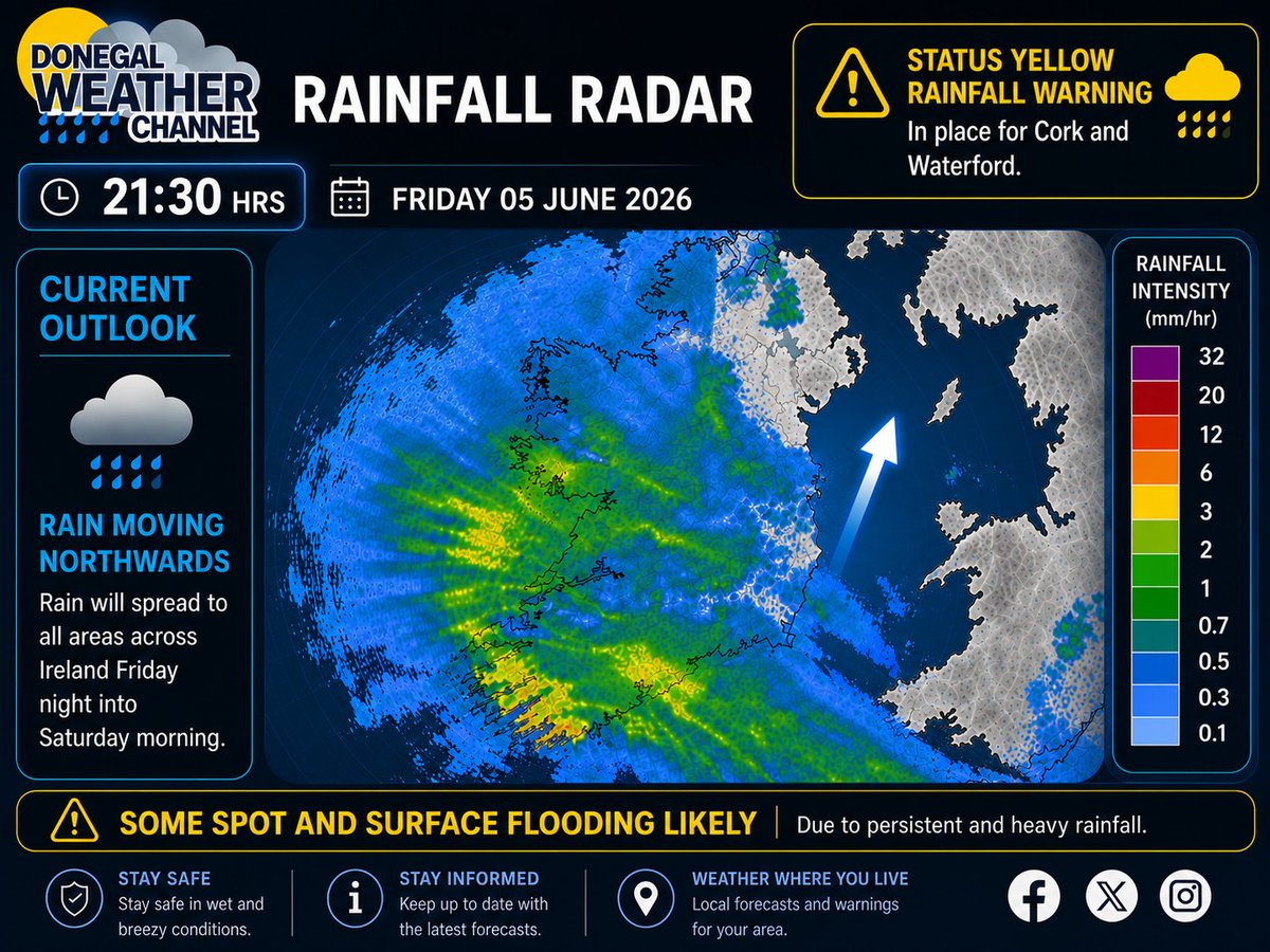
Heavy rainfall continues to move northwards and will spread to all areas around midnight into Saturday morning with some local spot flooding and surface water.
View the latest warnings here 👉 donegalweatherchannel.ie/wea…
☕You can also support my updates by buying me a coffee buymeacoffee.com/donegalweat…
#weather #ireland #fblifestyle #rain #rainfall
7
762
Potential Signals for Warmer & Drier Weather Mid-June 2026 ☀️
There are increasing signals that mid-June 2026 could turn warmer, drier and more settled across Ireland and parts of western Europe, although confidence remains moderate at this range.
Current ECMWF weekly anomaly guidance (15–22 June) shows a broad signal for above-average temperatures across Ireland and western Europe, with temperatures potentially running around 2°C to 6°C above average in places. A warmer-than-normal pattern is particularly evident across northern and western Europe. ECMWF sub-seasonal forecasts indicate a tendency toward higher pressure nearby and reduced rainfall signals, which can favour more settled conditions.
The pressure anomaly charts hint at higher pressure close to or west of Ireland, while recent GFS guidance also supports ridging/high pressure attempting to build toward Ireland and the UK, increasing the potential for more sunshine, lighter winds and drier spells. Rainfall anomaly charts suggest below-average precipitation signals across parts of western Europe, although rainfall forecasts at this range are naturally less reliable than temperature signals.
For Ireland, this could mean:
☀️ More settled weather at times
🌡️ Temperatures above seasonal average ( 2°C to 6°C possible)
🌦️ Reduced rainfall potential compared with normal
🍃 Greater chance of high pressure influence
As always at this lead time, details will evolve, but the early signs are encouraging if you’re hoping for a more summer-like spell.
Follow for updates:
donegalweatherchannel.ie
Kenneth from the Donegal Weather Channel
☕You can also support my updates by buying me a coffee. By buying a coffee you are helping secure the future of the page which helps in the maintenance and running costs 👉 buymeacoffee.com/donegalweat…
Forecast outlook based on ECMWF sub-seasonal and GFS model guidance — subject to change.
5
26
1,968
🟡☔ Status Yellow - Rain warning for Cork & Waterford
Click here for the latest warnings 👉 donegalweatherchannel.ie/wea…
#warning #ireland #fblifestyle #rain #rainfall
1
8
456
WET AND BLUSTERY WEEKEND AHEAD
This Friday afternoon, rain will begin to spread into the southwest of Ireland, moving northeastwards and affecting all areas by Friday night into Saturday morning. Expect very heavy rainfall that could lead to spot flooding. This stormy weather will be characterized by strong winds, particularly in the southwestern, southern, and eastern regions, lasting through Friday night into Saturday morning, before easing off Saturday afternoon.
Later in the morning, the rain will start to clear in the northeast for southern areas and will continue into the early afternoon for northern regions. Showers will follow, but it'll begin to dry out from the south by the evening.
On Sunday, anticipate another round of heavy rain across Ireland in the morning and afternoon, which may also result in some local flooding. Additionally, conditions will remain blustery due to southwest winds. Showers will ease from the southwest during the evening.
Kenneth from the Donegal Weather Channel
☕You can also support my updates by buying me a coffee. By buying a coffee you are helping secure the future of the page which helps in the maintenance and running costs 👉 buymeacoffee.com/donegalweat…
#weather #ireland #fblifestyle #rain #wind #flooding
3
19
1,401
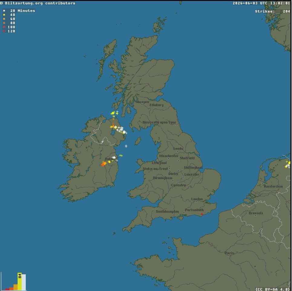
Plenty of Thunderstorms now popping up across Ulster and Leinster This afternoon.
Send on your reports and photos of thunderstorms to the page.
Track these thunderstorms here 👉 donegalweatherchannel.ie/liv…
#weather #ireland #fblifestyle #thunderstorm #rain #thunder #lightning
1
7
486
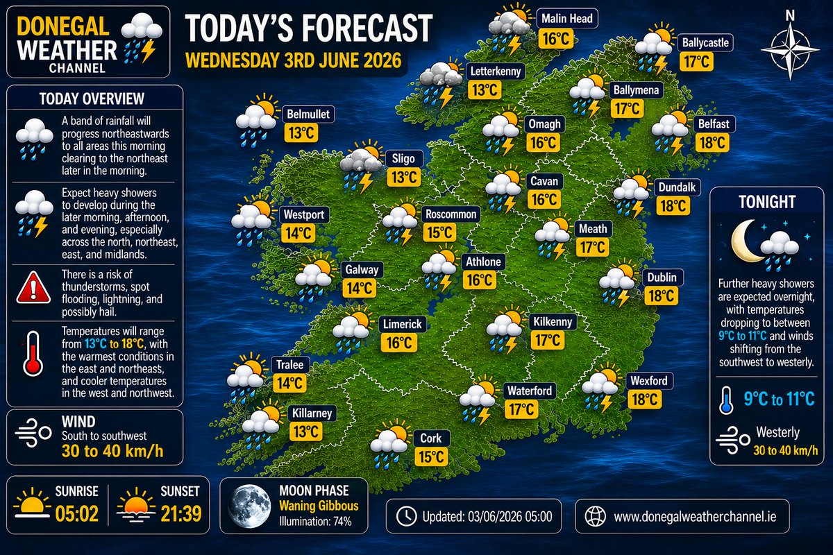
Good morning folks a band of rainfall will progress northeastwards to all areas this morning clearing to the northeast later in the morning. Expect heavy showers to develop during the later morning, afternoon, and evening, especially across the north, northeast, east, and midlands. There is a risk of thunderstorms, spot flooding, lightning, and possibly hail. Temperatures will range from 13°C to 18°C, with the warmest conditions in the east and northeast, and cooler temperatures in the west and northwest. Winds will blow from the south to southwest.
Further heavy showers are expected overnight, with temperatures dropping to between 9°C to 11°C and winds shifting from the southwest to westerly.
#weather #ireland #fblifestyle #rain #thunderstorm #thunder
9
701
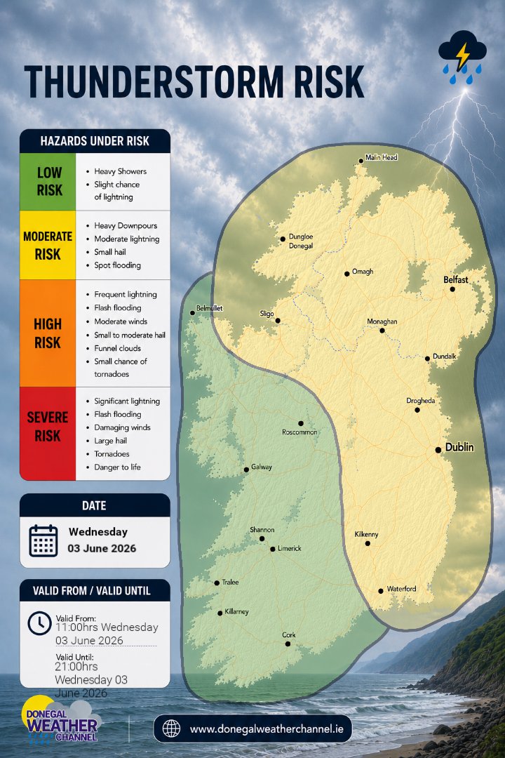
THUNDERSTORM RISK
Tuesday 3rd June 2026
🟡 MODERATE RISK
📍 Ulster, North and northeast Connacht, Leinster.
Heavy showers are expected with a risk of thunderstorm activity particularly for Ulster Leinster and north /northeast Connacht during the later morning, afternoon and evening . A band of rainfall will move up from the southwest on Wednesday morning moving northeastwards in direction clearing to the northeast by midday . During the later morning and afternoon some heavy showers and thunderstorms are likely to develop, bringing moderate lightning strikes, potential spot flooding, small hail with the potential for some funnel clouds. Across the midlands and northwest areas in the Moderate risk zone heavy showers are 1st expected to develop them moving northeast into Leinster and East/North Ulster.
🟢 LOW RISK
📍 Rest of Connacht and Munster
These areas have a low risk of thunderstorm activity, although heavy showers may still occur. A few lightning strikes are possible, especially near the boundary of the moderate risk zone.
⌚ Forecast valid from 11:00 hrs Wednesday 03rd June 2026 to 21:00 hrs Wednesday 3rd June 2026.
The Donegal Weather Channel will be issuing thunderstorm risk zones due to the anticipated thunderstorms over the summer months, which can be quite disruptive. Risk maps provide better guidance than warning maps, and I hope you find the new graphics helpful!
☕You can also support my updates by buying me a coffee. By buying a coffee you are helping secure the future of the page which helps in the maintenance and running costs 👉 buymeacoffee.com/donegalweat…
Kenneth from the Donegal Weather Channel
#weather #ireland #fblifestyle #thunderstorm #rain #thunder #lightning
1
10
568
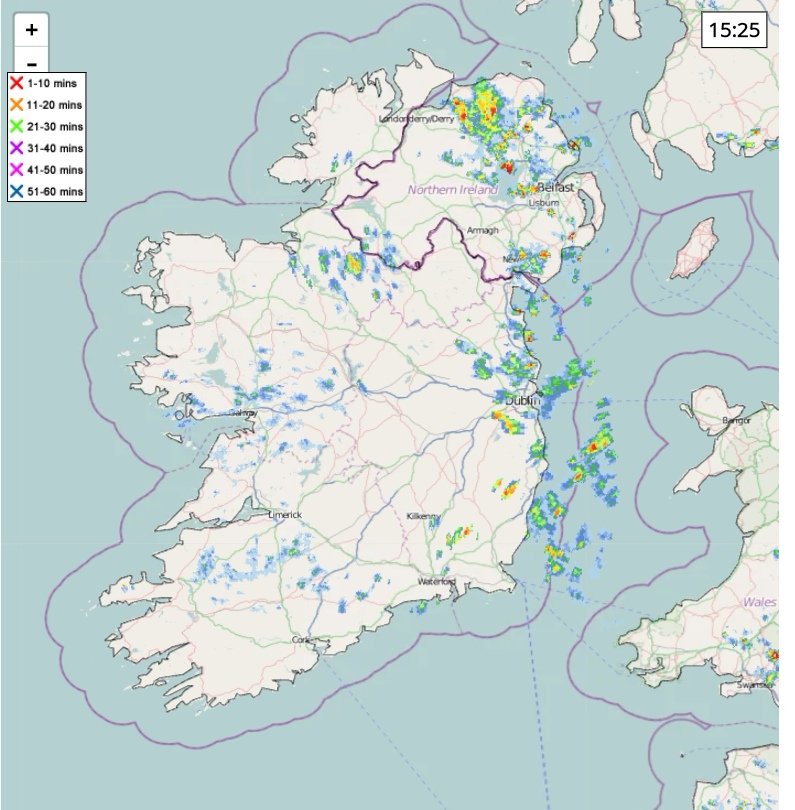
Heavy showers and thunderstorms in the northeast and east this afternoon with some downpours and flooding, some thunder a lightning reported across the east.
Kenneth from the Donegal Weather Channel
Track these thunderstorms here 👉 donegalweatherchannel.ie/liv…
#weather #ireland #fblifestyle #thunderstorm #lightning #thunder
2
12
877
On Tuesday, expect lots of clouds, in the east and southeast you'll find the best chances of sunshine. Scattered showers are likely throughout the morning and afternoon, with a few thunderstorms possible in the northeast. Showers are expected to ease off later in the afternoon and into the evening.
Temperature-wise, it will range from 14°C to 19°C, with the warmest areas in the east, southeast, and midlands, while the north, northwest, and southwest will be cooler.
Tuesday night will begin mostly dry with clear spells, but clouds will increase later, bringing rain into the southwest. Nighttime temperatures will be between 9°C and 12°C.
#weather #ireland #fblifestyle #Forecast #cloud #thunderstorm

9
543
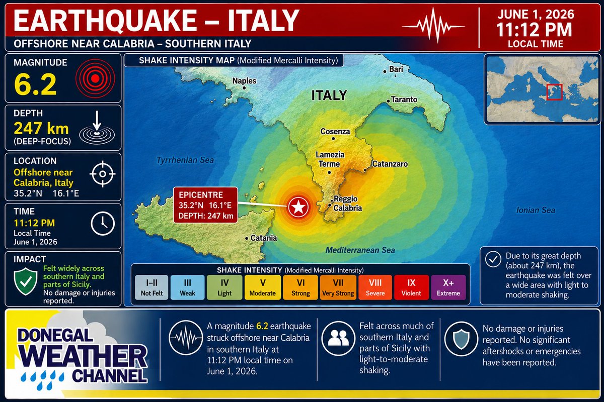
A magnitude 6.2 earthquake struck offshore near Calabria in southern Italy (around Cosenza/Lamezia Terme) at approximately 11:12 p.m. local time on June 1, 2026.
Due to its great depth (about 247 km), it was felt across much of southern Italy and parts of Sicily with light-to-moderate shaking, but caused no damage or injuries. No significant aftershocks or emergencies have been reported.
#italy #earthquake #ireland #tremor
8
983
THUNDERSTORM RISK
Tuesday 02nd June 2026
🟡 MODERATE RISK
📍East Ulster, Northeast Leinster.
Heavy showers are expected with a risk of thunderstorm activity, particularly in eastern Ulster and northeast Leinster during the later morning and afternoon. A few thunderstorms are likely to develop, bringing moderate lightning strikes, potential spot flooding, and small hail.
🟢 LOW RISK
📍 Rest of Ulster, East & Northeast Connacht, the much of Leinster.
These areas have a low risk of thunderstorm activity, although heavy showers may still occur. A few lightning strikes are possible, especially near the boundary of the moderate risk zone.
⌚ Forecast valid from 09:00 hrs Tuesday 02nd June 2026 to 18:00 hrs Tuesday 02nd June 2026.
The Donegal Weather Channel will be issuing thunderstorm risk zones due to the anticipated thunderstorms over the summer months, which can be quite disruptive. Risk maps provide better guidance than warning maps, and I hope you find the new graphics helpful!
☕You can also support my updates by buying me a coffee. By buying a coffee you are helping secure the future of the page which helps in the maintenance and running costs 👉 buymeacoffee.com/donegalweat…
Kenneth from the Donegal Weather Channel
#weather #ireland #fblifestyle #thunderstorm #rain #thunder #lightning

2
10
573