
🏆 Emmy & 2× PAB Award-Winning Drone Pilot | FAA Certified | Meteorologist | Water Safety Advocate | Surfer | Food & Whiskey Snob | Jersey Shore × PA
Joined March 2013
- Tweets 13,090
- Following 497
- Followers 4,165
- Likes 5,874
5,845 Photos and videos


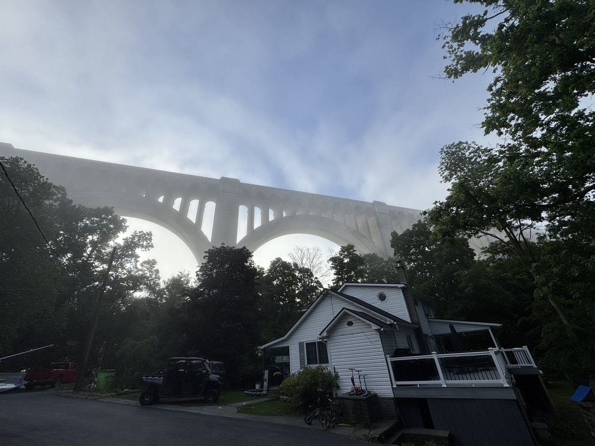


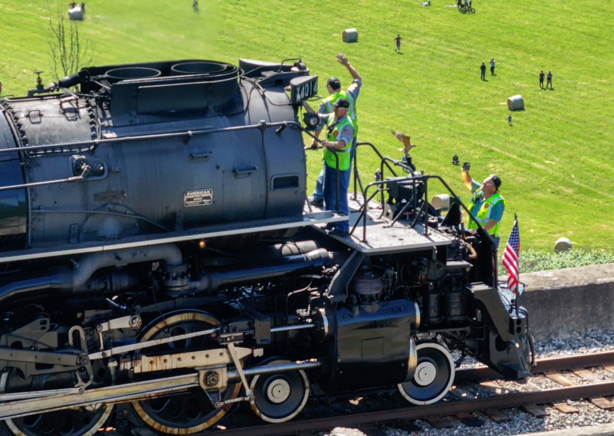
THE VIDEO: Union Pacific Big Boy 4014 passes over the Tunkhannock Viaduct.
A 1.2-million-pound steam legend crossing one of the largest concrete railroad viaducts ever built. Nicholson, Pennsylvania delivered an unforgettable scene today.
43
684
5,795
156,442
Big Boy 4014 thundering across the Tunkhannock Viaduct in Pennsylvania’s Endless Mountains. Absolutely unreal.

20
299
2,810
75,952
Gearing up for the Big Boy 4014 pass across the Tunkhannock Viaduct in the Poconos! 🚂
2
72
1,817

Jun 6
Severe T'storm Warning for southern Dauphin, Lebanon, and eastern Perry until 6:15 pm. 60 mph winds and penny sized hail possible.
1
177
Jun 6
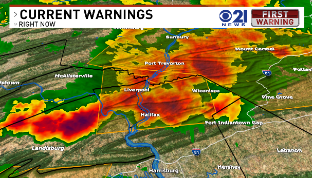
Severe T'storm Warning continues for northern Dauphin, northeast Perry, and extreme eastern Juniata counties until 5:30pm. 60 mph wind gusts possible.
1
165
Jun 6
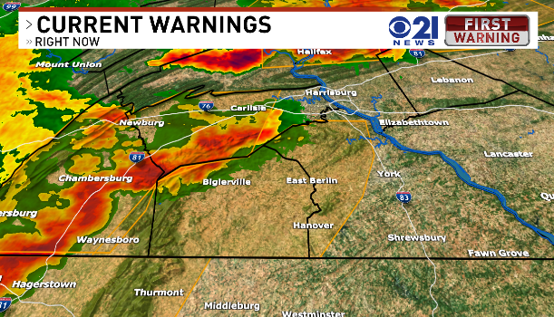
Severe T'storm Warning for Adams and York counties for 70 mph winds. The warning is until 6pm!
1
1
137
Jun 6
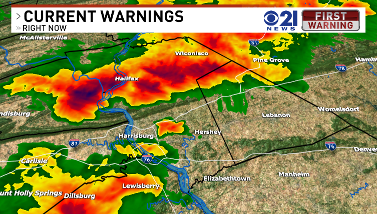
Severe T'storm Warning for Cumberland and Franklin counties until 5:30pm. 70 mph winds are possible with this storm.
125
Jun 6
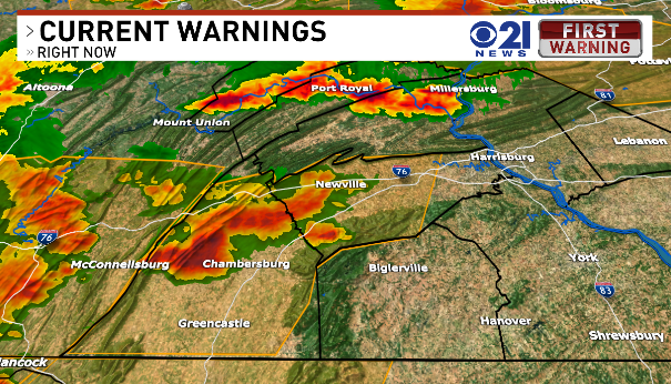
The Storm Prediction Center has upgraded all of Central PA in an enhanced risk (3/5) for damaging wind gusts. This threat level only occurs a few times a year if that. Stay weather aware through the evening.
1
157
Jun 6
Plenty of severe t'storm warnings to our northwest (orange boxes). Be weather aware this afternoon and evening as the storms move through. Damaging wind gusts and hail possible!
2
112
Apr 28
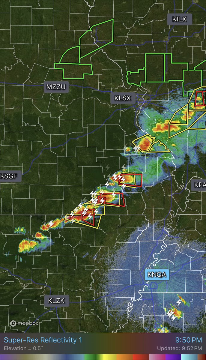
That radar hole in SE Missouri is brutal tonight. It sits between radars, so we’re basically blind to low-level rotation… tornado signatures could be there, but harder to see.
1
1
274
Apr 23
The “solo FPV drone pilot” thing in ads? Goggles = no VLOS. No VLOS = not compliant with FAA rules. Funny how they never show the visual observer.
1
1
273

Mar 17
A popular weather page posted this ahead of yesterday’s severe threat. Completely reckless and irresponsible. This creates unnecessary fear, not preparedness. We as meteorologists / science-communicators are losing the battle to these toxic pages.
18
7
91
10,614
Mar 16
In most situations, it should take no longer than 20 seconds to reach your shelter when a warning is issued. Have a plan for those w/ limited mobility, & crate pets in your shelter BEFORE a warning is issued. These two situations are often overlooked... can't stress that enough.
5
346
Mar 16
Some messy/disorganized clusters already across VA could reduce degree of instability for the afternoon round which is good. Latest trends are certainly moving in the right direction of a potentially more limited severe threat. Still need to remain weather aware today.
Mar 15

Tomorrow’s setup for central PA doesn’t need tons of sun. Strong dynamics and shear mean storms can rapidly destabilize even with limited heating. Tornadoes are possible. The main question is storm mode… if storms are messy/disorganized early, that could temper overall threat.
6
713
Mar 15
Tomorrow’s setup for central PA doesn’t need tons of sun. Strong dynamics and shear mean storms can rapidly destabilize even with limited heating. Tornadoes are possible. The main question is storm mode… if storms are messy/disorganized early, that could temper overall threat.
1
14
1,685
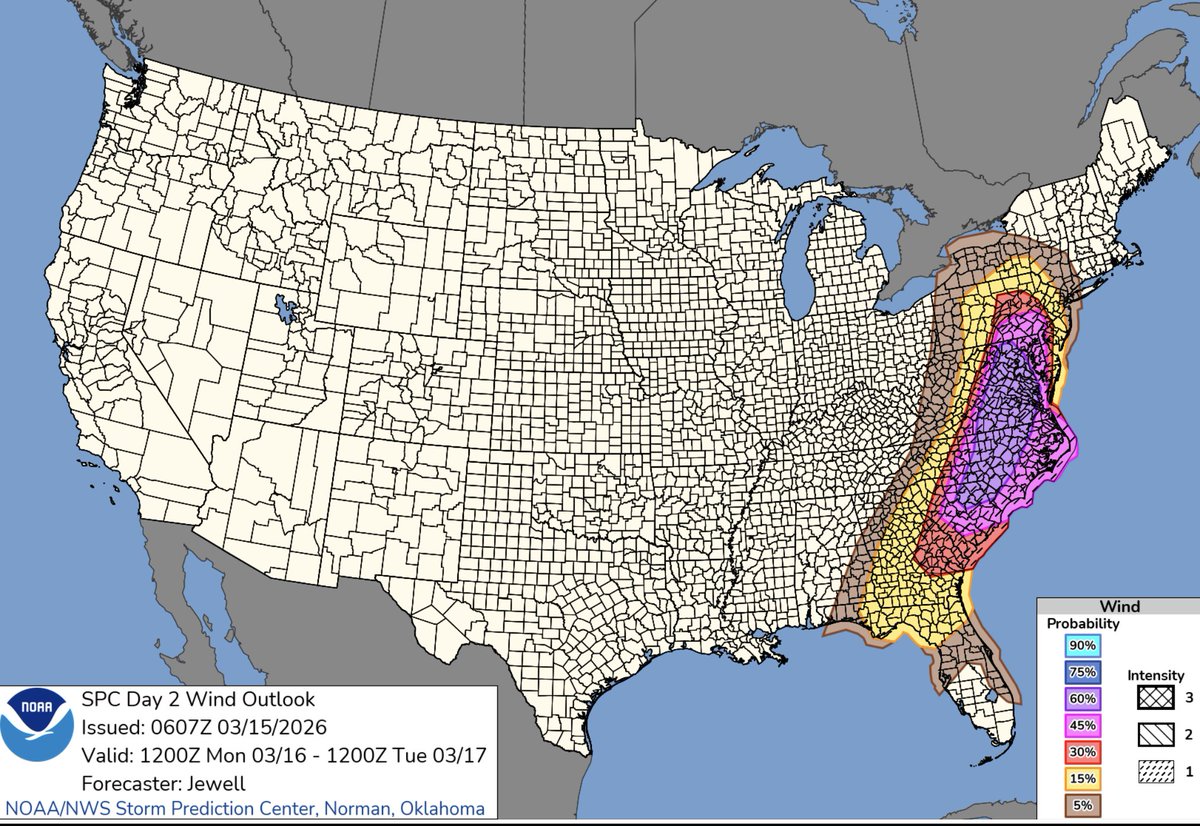
Mar 15
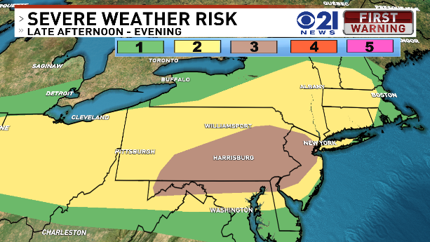
A 45% severe wind probability area in Central PA, especially at Day 2, is very rare. This speaks to the level of confidence in widespread damaging wind gusts in tomorrow’s severe thunderstorm setup. 60% probabilities extend just to our south into central MD.
12
501

Mar 12
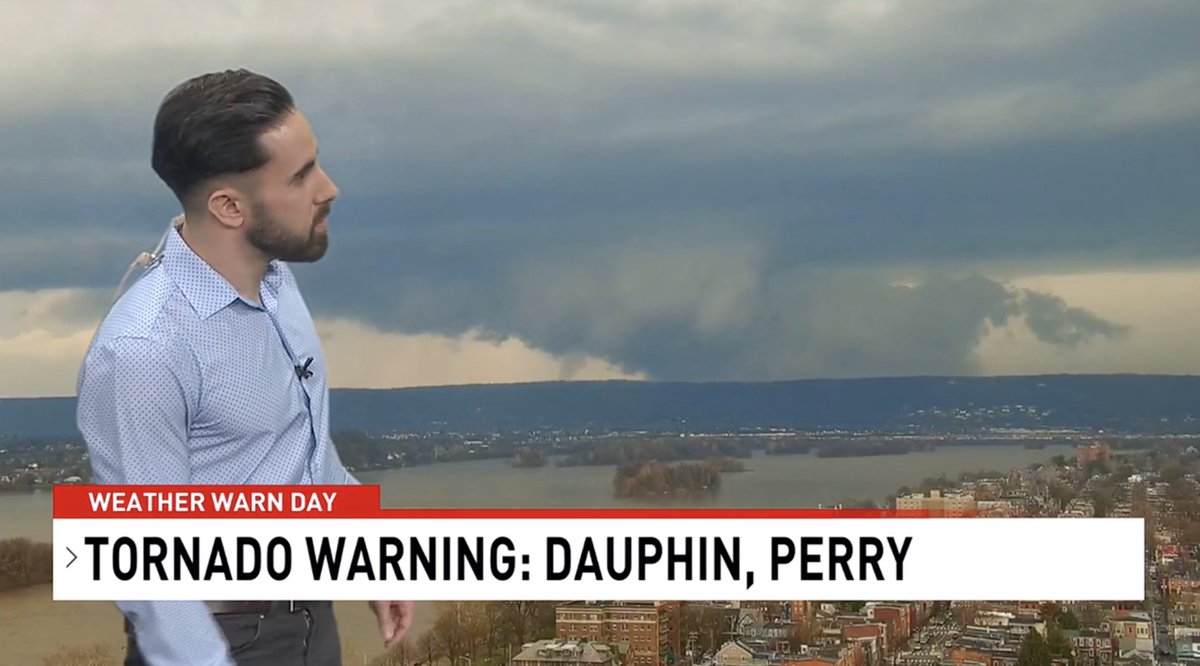
We tracked a rotating wall cloud, the parent cloud of a tornado, live on the air last night using our tower cam in Harrisburg. By pure luck, we had a perfect view of it. Thankfully, there were no reports of damage or injuries. #pawx
16
562