
Edfu Books has been publishing for 30 years, and has handled all of the books written by Ralph Ellis.
Joined January 2026
- Tweets 1,512
- Following 35
- Followers 73
- Likes 2,071
246 Photos and videos


*** Doestoevsky, Rome, and Universe-25 ***
Marx argued for a communist utopia, where everyone was equal and provided with all the needs of life. He envisioned a blissful communist life, full of leisure and luxury. However, Doestovesky argued that life without struggle is no life at all - what can you do all day in a utopia, bar eating, sleeping, preening and copulating?
So who was right, and can such a contention be tested in the real world? What will happen, if you give a society all the luxuries of life? Well, a glance at ancient Rome could have provided a clue - the Patrician classes lapsed into idle luxury, with every human need catered for many times over, yet the result was they eliminated themselves from the gene-pool:
youtube.com/watch?v=AeTfKDmf…
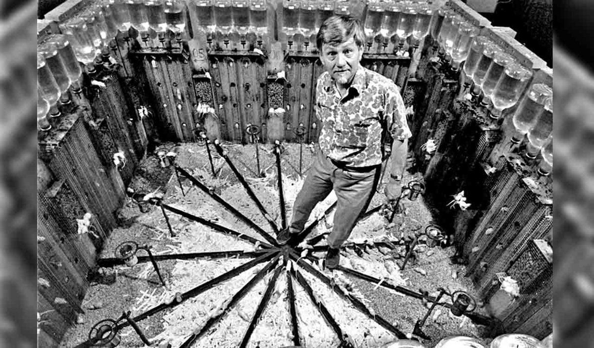
To scientifically test these competing ideologies, biologist John Calhoun set up a mouse utopia called Universe-25. This vast mouse world had enough space for thousands of mice, and catered for their every need. These would be pampered Marxist mice, where all food, water, warmth and housing needs were supplied by the humanoid gods in the heavens above. It was rodent Heaven on Earth, where all the mice had to do was pray to their humanoid gods five times a day.
Not surprisingly the eight diverse founder mice thrived in this mouse heaven, doubling their population every 55 days. But the growing pampered population had nothing to do, and a myriad of social problems arose. Some engaged in needless fighting, while the ‘Beautiful Ones’ withdrew from society and just preened themselves all day.
The utopian mouse population grew to 2,200, but then the population crashed and within five years all the mice were dead. All of them. Surprisingly, the population did not re-learn normal mice behaviour as the population declined, they just gave up on life and died.
Unfortunately for all the Marxist agitators on university campuses (who desperately seek a communist utopia while hiding their ample trust funds), the Universe-25 Mouse Utopia was a Marxist Catastrophe.
This is an experiment that the political left prefer to ignore - so much so that it has not been repeated. They will claim these rodent lessons cannot be transferred upon human society, and yet they obviously can. Similar social stresses and breakdowns have underpinned the failure of Communism all over the world, from Maoist China, to Stalinist USSR, to MusIim lslamia; plus the similar example of Roman Patrician classes above.**
A Marxist world without the need for effort or ambition results in lethargy and stagnation, and the current American drive for equity will do exactly the same. Those who benefit from equity (equality of outcome) will either be incompetent or unmotivated, while those who are disadvantaged by equity will simply give up. Why bother advancing yourself, if you just get trodden into the dust by your incompetent and undeserving peers?
The same has happened recently in modern China, with the 'Lying Flat', 'Let it Rot', or 'Burn it Down' movements. A generation that sees no hope of advancement and no hope of a stable and happy family life - this time by unrealistic property prices - simply give up. Note that this is a capitalist failure, rather than a communist failure - if the next generation have no jobs and get priced out of life, they give up on life.
Communism is a stick, while Capitalism is a carrot. But if capitalism can no longer provide enough carrots, the social system again fails.
youtu.be/uWl7njLlXLU?si=9zxj…
youtube.com/watch?v=IfgFNRnX…
Note that the communist WEF are fully aware of Rodent Universe-25 and its implications for human society, yet they want to set up Humanity Universe-25 for us. Why would they want that?
Universe 25, the Mouse Utopia.
sciencehistory.org/stories/m…
.
** Note:
IsIam is not Marxist, but suffers from similar effects and problems. Islam preaches that your life is predestined, and that Allan will look after you whatever you do - whether you make every effort or just chill out. This engenders a mindset similar to the Rodent Utopia, except there is only a preached promise of Umma Utopia rather than any guaranteed Marxist Utopia. But the result is similar, with lethargy, incompetence, and violence becoming a societal norm.
Winston Churchill’s 19th century observations about Islam in his ‘River War’ says the very same thing. However, I am not allowed to quote from Churchill, as X will take this post down. Note that the slightly counter-intuitive Golden Age of lslam was actually based upon the hard work of subjugated dhimmi unbelievers in lslamic lands, via the jizyya tax system, but when the dhimmi population reduced due to emigration and death, the economy of the East predictably crashed. See link below.
Allen should have stuck to running his snackbar in East London, rather than meddling in human affairs. See image.
Islamic Inventions were Roman and Greek:
academia.edu/8749355/Islamic…
(Originally written in 2022.)
Ralph

1
1
2
332
*** Year Zero — from the Zodiac, Not from Jesus ***
There is a common misconception that our Year Zero is dating years and centuries from the birth of Jesus. This is not true. In reality, our year zero represents the dawn of the new Great Month of Pisces. And since Jesus owned a zodiac, as we saw in a previous TwiX, the zeroing of our millennial calendar became associated with Jesus.
The signs of the zodiac change every 2,200 years or so, due to the precession of the equinox, and thus the Great Month of Aries changed into the Great Month of Pisces in Year Zero (AD 01 or AP 01). (More like AD 10, but AD 01 is good enough.) Which is why Jesus was born as a Lamb of God (Aries) but became a Fisher of Men (Pisces). Jesus was born under Aries (just), but rapidly became a Piscean. This is the reason that the symbol of Christianity became the fish; and why the pope wears the Fisher Ring and the fish-mouth mitre. See the image below.
Thus Jesus was the first king of the new Great Month of Pisces, so he was the first of the Arthurian Fisher Kings - the Kings of Pisces. Just as Alexander the Great and Ptolemy III wore the horns of a ram, to identify themselves with the Great Month of Aries, so the Fisher Kings identify themselves with fish and fishing.
It is has been said (or sung) that we stand at the ‘Dawn of the Age of Aquarius’, but in reality we will not reach that change in the Great months until about AD 2400 (AP 2400). And then we will zero the dating system once again. Our present era is actually AP Anno Pisces (Year of Pisces), not Anno Domini (Year of Lord), and after year 2400 AP, we will become AA (Anno Aquarius).
Note 1:
Modern astrology has not updated its star charts since the Jewish Revolt (they lost the knowledge of how to do so). So all of our modern astrological signs are in the wrong place - they are a whole month displaced from their true positions. So all the astrological star signs people follow, are wrong.
Note 2:
Jesus was not born in year 0. The most likely date is AD 6, during the census by Quirinus. So the Herod in question would have been Herod Archelous, rather than Herod the Great. And yes, Jesus did indeed go to Egypt. But this was less of a flight from Herod, and more of a relocation to the best university in this era - Alexandria. As a prince of Syria and Judaea, King Izas-Jesus would have had the best education possible. And it was in Alexandria that Jesus met Heron, who made the trick water-to-wine jugs - as we will discussed in the next TwiX.
Image:
A modern fisher-ring, with Simon Peter Kephas fishing for new converts and congregations to the Great Month of Pisces. It is a shame that the Catholic Church has forgotten what this fish symbolism means.
Ralph Ellis

1
1
198
*** Jesus Owned a Zodiac in Galilee ***
In previous TwiXes, we have seen the links between the biblical King Izas-Jesus of Edessa, and the Egyptian monarchy. With Jesus being called the Egyptian False Prophet in the gospels and in the works of Josephus.
So it should not be so surprising that the most important symbol within the Nazarene Sect of Jesus and James, was the zodiac. Thus many ancient synagogues in Judaea contain a large and elaborate mosaic zodiac. And all of these Jewish zodiacs portray the Greek Helios at the center, which is somewhat heretical for a Judaic sect.
These were complex zodiacs that embody and display the precession of the equinox, which is why the constellations in this zodiac run anti-clockwise. In addition, the head of Helios resides between Aries and Pisces - a position which denotes a precessional date of AD 10, and this is likely the construction date of this zodiac. Note also that Helios holds a spherical ‘blue marble’ Earth in his gravitational grasp, demonstrating that the Heliocentric model of the Solar System was known. The lines of latitude and longitude on this earth are curved - so there were no flat-earthers in the Egypto-Judaic Sabaean Church of Jesus and James.
The Hamat zodiac was owned by Jesus (of Gamala-Sapphias), who was the leader of 600 rebel fishermen. The connection here with the gospel story is obvious, especially as Jesus was born in the early 1st century.
Again note that the head of Helios is positioned between Aries and Pisces. This is why Jesus was born as a Lamb of God (Aries) but became a fisher of Men (Pisces) - because much of Nazarene Judaism symbolism was astrological. But Saul-Paul knew nothing of these deeper initiations into the true Church, which is why Christianity does not follow the zodiac. (With Christianity being the Church of Saul, not the Church of Jesus and James.)
Josephus Flavius was sent to destroy this zodiac in about AD 65, because it contained heretical images of animals, as he himself relates. So again we have a fairly good idea that this zodiac dates from the early 1st century.
Image:
a. The Hamat Teverya zodiac, on the Sea of Galilee.
b. The spherical Earth.
Ralph

1
2
164
*** Jesus was a Freemason ***
In previous TwiXes, we have seen that the gospel Jesus was a prince and king of Edessa, a principality in northern Syria. But how could this be so, if he was merely a carpenter?
Actually, Jesus was NOT called a carpenter, he was called a tekton τεκτων, meaning ‘architect’. We still use the same word in the English - the Chief Tekton or Archi-Tect. However, this title did not refer to an operative architect, but to a speculative architect - a Freemason. We see evidence for this in the Raising of Lazarus in the gospel of John.
Quote:
When (Jesus) had heard that (Lazarus) was sick, he abode two days in the same place ... Then he said to his disciples, Let us go into Judaea ... Then said Jesus, Lazarus is dead; and I am glad for your sakes that I was not there, so that you may believe ... When Jesus came ... he said, Take away the stone; but Martha said unto him, Lord, by this time he stinketh ... And when (Jesus) thus had spoken, he shouted: "Lazarus, come forth". And he that was dead came forth, bound hand and foot with graveclothes: and his face was bound about with a napkin. (John 11:1-44.)
This is simply a Masonic 3rd Degree raising, complete with the initiate being wrapped in a shroud and hoodwinked. However, it appears that the original 1st century ritual was rather more demanding than the short 30 minute incarceration for modern candidates.
The 1st century candidate into the 3rd degree of Freemasonry was entombed in total darkness for three days. Trapped and totally dependent upon rescue by his ‘brothers’, and only to be released upon the fourth day. Now that was a true test of initiation and reliance upon your ‘brothers’.
.
Note: For non-Masons, the 3rd Degree is a re-enactment of the death and resurrection of Hiram Abif (or Heru-m-Atif) the chief tekton or chief architect of king's David and Solomon, who designed and built the Temple of Solomon.
Although some Lodges indicate that this ceremony was originally based upon the death and resurrection of Osiris, and the building of the pyramids. Osiris is strongly connected to Judaism, because Moses' Egyptian name was Osarseph (Osar Seph) meaning Son of Osiris. While the Torah Joseph was prime minister of Egypt, and his Egyptian names were Peterseph and Zaphnath.
Egyptian names of the Patriarchs:
... Peter Seph = Son of Ptah
... Nath Seph = Son ot Neit
See previous TwiXes for the Egyptian hieroglyphic spelling.
Since Ptah was married to Neit, it is not surprising that Joseph was symbolically the son of this god and goddess couple. Note that the gods themselves know what a man and a woman is, even if Joe Biden and Kier Starmer did not.
Note also that Ptah and Neit were Architects of the Universe and patron deities of architects, and they were therefore Freemasonic gods. Thus Jesus as a 'carpenter' (an architect) held the same title as the Old Testament Joseph.
Yes - Judaism has deep roots that extend way back into early Egyptian theology.
Image: Jesus helps a hoodwinked Lazarus come forth from the tomb, having completed his 3rd Degree.
Ralph Ellis

1
1
170
*** History of Jesus on Audio and Kindle ***
In previous TwiXes, we have begun to look at the life of the true historical Jesus, who was a prince and king of Edessa.
Readers are obviously intrigued, but looking for confirmation and references. Please be assured that all this information has been taken from orthodox historical sources, and analysed in a scholarly, dispassionate and agnostic fashion.
Yet despite my agnostic treatment of these early manuscripts, the conclusions I have reached are no less controversial. For the chronicles do all point towards the gospel Jesus being a real but largely unknown historical prince and king of Edessa. The reason for this historical lacuna (or vacuum) being that Rome (ie: Josephus Flavius) has deleted the Edessan monarchy from history. Were it not for the Syriac historians, we would know almost nothing about them, and Rome’s strategy of obfuscation and deletion would have succeeded.
So if you enjoy audio books, do join this continuing adventure with Google Play.
I chose Google Play, because Amazon Audible would not allow digital voices at the time, and Google’s production platform was far superior. The Google voice is so natural, you can hardly tell it is digital. I chose a soft, studious English male voice, for its worldwide acceptability. Subsequent to this, Amazon have banned me from uploading anymore books, so these books will not get onto Audible.
So do join us on Google Play, as we continue to explore the true historical history of the gospel story. The gospel story that details the tragic history of the Jewish Revolt against Rome, and the unsuccessful Edessan bid for the Throne of Rome.
Google Play Audio Books:
The King Jesus Trilogy, in four parts.
play.google.com/store/books/…
Amazon Ebooks and Paperbacks
The King Jesus Trilogy, in four parts.
amazon.com/dp/B09Q3H8H84
Apple ibook versions are also available for iPads.
The Apple eBook reader used to be far superior to Kindle. But the Apple sales effort was utterly useless, and the Kindle platform has greatly improved.
books.apple.com/.../jesus-ki…
Ralph Ellis.
1
1
94
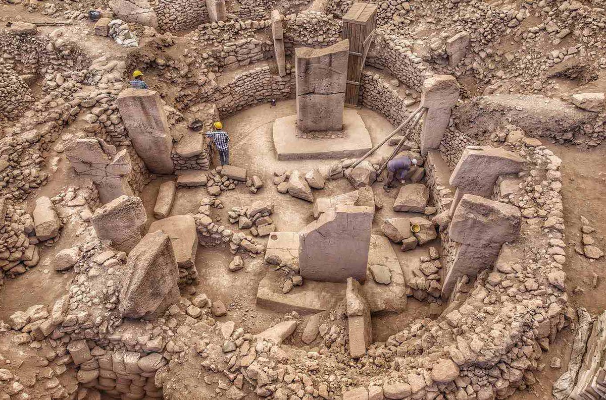
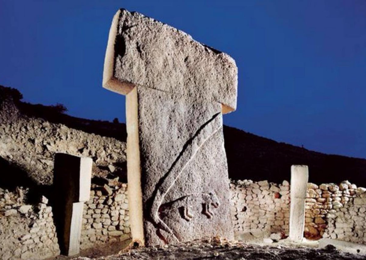
*** Gobekli Tepi and Chaco Canyon Necropolii ***
In the last TwiX, we saw how the Tepi Temples in Anatolia might represent the zodiac. But what were they used for? What was their religious or ceremonial function?
These ancient Tepi Temples contain a cluster of circular enclosures, likely symbolising the zodiac and therefore the heavens above, with many rectangular buildings behind them. The circular enclosures often contain benches around the perimeter, and two monolithic standing stones in the center, most probably representing the Sun and Moon that often stand at the center of a zodiac. But where else in the world might we find these same elements?
Ah yes, in Chaco Canyon in New Mexico.
In Chaco we see several large building complexes that were initially thought to be towns; or, since the entire 'settlement' is walled, perhaps we might call them citadels. The handful of these so-called citadels that reside within the Chaco Canyon all contain a cluster of seemingly ritual circular enclosures, plus many rectangular buildings behind them. The circular enclosures often contain benches around the perimeter, and sockets in the center that may have contained standing stones or tree-trunks. And the entire Chaco site is replete with solar and lunar alignments.
So even on the surface, we can see many similarities between the Gobekli and Chaco sites that are intriguing, to say the least. But there is more.
These Chaco Canyon sites - especially the main Pueblo Bonito ‘citadel’ - have been reevaluated in recent years, because there is no real sign that these vast citadels were actually lived in. Many of the tall ‘apartment blocks’, which reach up to four floors in height, have no easy access (no corridors); the individual rooms have no natural light; and there are no chimneys to allow fires for cooking or for warmth. In other words, these multi-story room complexes are completely hopeless and unusable as apartment blocks. So what are these vast citadels, and their prison-like rooms, really for?
Since these citadels are undoubtedly aligned with Solar and Lunar alignments and transits, archaeologists are now suggesting that Chaco was a seasonal ritual center. People came to this temple site during the spring and autumn months, when weather conditions were more tolerable, and paid homage to the gods. And perhaps some of the more influential visitors were initiated into the mysteries of the cosmos at this great temple site, with the circular enclosures representing the zodiac or the cosmos, just as I have proposed for Gobekli and Karahan Tepe. Chaco Canyon may have been the Eleusinian Mystery School of the Americas. Whatever the spiritual purpose of these circular enclosures may have been; with their secret rituals complete the faithful pilgrims would have eventually travelled back to their homes, leaving the site in the care of a few caretakers, guardians, and priests.
In other words, the Chaco Canyon temple complexes may have been akin to the Masjid al-Haram temple site in modern Mecca; a name which either means Sacred Mosque or Forbidden Mosque depending upon who you ask. Just as in modern Saudi Arabia, peoples from all over north and south America may have made a Hajj-style pilgrimage to Chaco, at least once in their lifetime, to gain the blessings of the gods. This new reappraisal would actually make a great deal of sense for the Chaco site. But if Chaco was a seasonal temple, was Gobekli Tepe a Hajj pilgrimage site too? Not a settlement, nor a simple temple for the local population, but a site of pilgrimage for peoples from all over Mesopotamia? Were the thousands of grind-stones discovered at Gobekli not simply for making bread for the local population, but to cater for the thousands of pilgrims who made the long summer trek to this sacred site?
(Note: I have already made a similar proposal for the Giza complex in Egypt. The large bakery and butchery facilities discovered at Giza were not made to feed the construction workers, but to cater for the pilgrims who arrived at this premier pilgrimage site of the Mediterranean. These facilities were especially useful for the many bread and meat offerings that pilgrims were expected to give to the gods; thus creating a new class of perennially overweight priests.)
While these suggestions are quite possible, the design of the Pueblo Bonito ‘citadel’ in Chaco Canyon may actually give us a better understanding of these ancient sites. What of all those completely uninhabitable prison-like rooms that line the perimeter of this site, what were they really for? Due to their peculiar design, it has been seriously proposed that these rooms or cells were merely structural - designed to buttress the large and straight back wall of the site. But I don’t think that five rows of cells or rooms would be needed for the structural integrity of the rear wall. And even if the designer did think this was necessary, these rooms could still have been equipped with corridors, chimneys, and skylights to make them more habitable. So why this curious design?
Perhaps we should travel back to Edessa (to Gobekli Tepe), once more, for an answer to this conundrum. Just to the southeast of Edessa-Gobekli is the royal Edessan necropolis of Sogmatar, which contains a series of truncated round-tower ’tombs’ atop some small rolling hills; containing rolling-stone doors and descending passageways down to small subterranean caverns. Although these towers and chambers are similar to Egyptian pyramids in their overall design, these were not tombs in the Egyptian tradition, but necropoli in the Judaic tradition. These tower-tombs were actually ‘sarcophagi’ (literally, ‘body-eaters’) where the bodies of the dead were laid out in the small subterranean caverns for a few years to decompose. Eventually, the bare bones of the departed would have been gathered up and taken home in an ossuary-box.
This, I believe, is what the uninhabitable ‘apartment rooms’ at Pueblo Bonito were for. Just as at Sogmatar, Chaco was a vast necropolis for these peoples, which resided in a remote and enigmatic location in Chaco Canyon - just as Sogmatar is in a remote and enigmatic location in the undulating ‘badlands’ to the southeast of Edessa-Gobekli. Andrew Collins once described Sogmatar as being ‘sinister’ - and while the site does not really justify that term, it is certainly occult (hidden) and enigmatic.
Thus people would come to Chaco Canyon with their dead, from all over the central Americas, to perform a sacred ritual of death and perhaps rebirth in one of the many circular enclosures. These are round ritual enclosures that may have represented the zodiac and thus the cosmos, just as at the Tepi Temple sites. With the ritual complete, the body would be respectfully placed in one of the many rectangular storehouses at the back of the Pueblo Bonito site (or one of the other nearby ‘citadel’ sites), until the body had completely decomposed. This was an uninhabitable room that had been deliberately designed without windows or chimneys, to minimise smells and flies and to promote a more esoteric decay process.
Entombed in perennial darkness, just as we see at the Sogmatar necropolis, the decaying deceased could face towards the curving and revolving transit of the Sun- and Moon-gods, for their souls to merge as one with the divine. Then a few years later, the family would come to collect the bones and handsomely reward the guardians of the necropolis site for their services.
While this makes a great deal of sense for the Chaco Canyon site, does this also describe and explain the nature and usage of Gobekli and Karahan Tepi Temples? Were the Anatolian Tepis necropolis centers, with the dead passing through the rituals of death and rebirth in the circular enclosures, before being laid to rest in the square ‘store rooms’ that lay just behind? Is that why these small square rooms all contain miniature T-pillars, marking them as being ritual rather than profane rooms?
If so, this would be an interesting development in our understanding, because it would not only imply fairly sophisticated technologies to construct these megalithic enclosures, but also a fairly sophisticated transport network to supply these centers with sufficient trade to justify their existence.
How far can one travel with a corpse, to reach a necropolis? Sogmatar is only 30 km from Edessa, or just over a day’s travel, so within easy reach. But the road network that surrounds Chaco Canyon suggests that people travelled from much further afield to reach the Chaco Canyon necropolis. So which prosperous cities were served by this vast and obviously wealthy necropolis site? Where did their funerary trade come from, and how far did it travel?
That New Mexico may have had a large necropolis complex should not be too unexpected, as many cities around the world constructed similar complexes. Although this does imply a thriving and wealthy population residing within perhaps 150 km of Chaco. In addition to the royal necropolis at Sogmatar, the cities of Edessa and Harran also had the plebeian necropolis at Shuayp, which is a vast complex of underground tunnels and niches for the dead. But these are haphazard complexes, displaying none of the architectural refinement and celestial symbolism of Gobekli and Chaco.
In a similar fashion, both Rome and Paris had extensive underground catacombs for the upper and middle classes, with the Paris complex being said to hold the remains of over six million people. Yes, sending the dearly departed safely into the afterlife was big business in these early eras, and could easily have supported the vast constructions that can be seen at Chaco Canyon and Gobekli Tepi -- if there were sufficiently large populations in the region to supply the trade.
The only fly in the ointment for this new comparison and exploration of these sites, is the vast time and distance that exists between these very similar temple complexes. Gobekli is being dated to about 11,500 years ago, while Chaco is being dated to just 1,000 years ago - which represents a gaping 10,500 year lacuna between their potentially conflated usage and chronologies. Could traditions as similar as this really span continents and millennia, while remaining true and faithful to their original designs and traditions? Is that really possible?
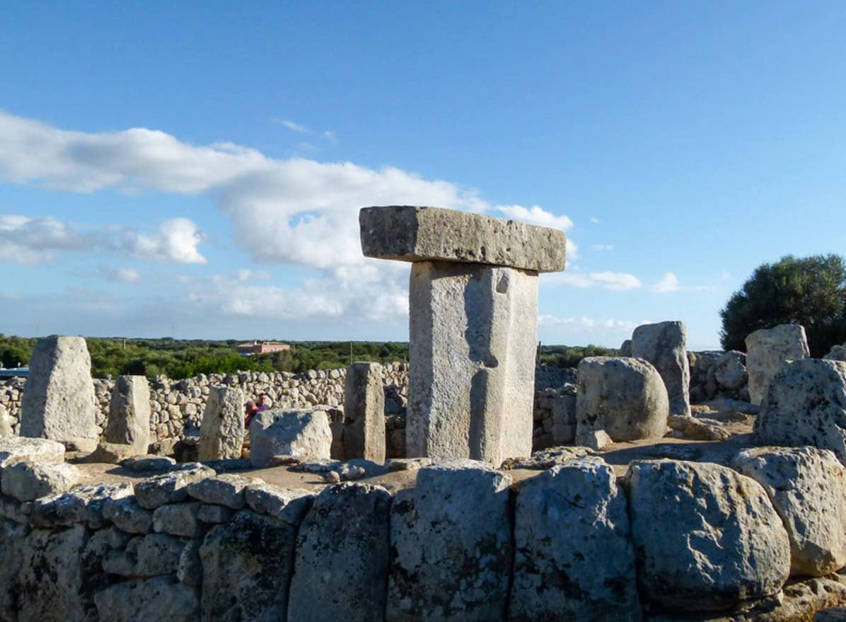
Having said that, do note that we have seen similar geographic and chronological lacuna before. I have already written about the T-shaped Taule monoliths of the Balearics, which reside in circular enclosures in a very similar fashion to the Gebekli and Karahan sites. Indeed, the Balearic Taules are also closely associated with subterranean pillar halls, which are more rudimentary than the subterranean pillar-halls at Gobekli and Karahan, but are nevertheless remarkably similar. And yet despite the many similarities between these sites, there are 4,000 km and 8,000 years between them - and that is a problem.
The other problem with dating Pueblo Bonito in particular, is the lack of carbon-14 dating on the site. In 1996 Windes and Ford completed the ‘Chaco Wood Project’, which attempted to date the Pueblo Bonito ‘necropolis’ by investigating the many large wooden lintels and supports used throughout the site. However, they only used dendrochonology, rather than C14 dating, and derived a 250-year period of occupation from the 9th to 12th centuries AD. But why would you not want to confirm these tree-ring dates, with the more reliable C14 dating method? Especially as these are pristine wood samples, which would have experienced little C14 contamination from limestones or soot from hearth-fires etc:
As I have mentioned many times previously, there are manifold problems with dendrochronology. The first is that tree-ring growth and therefore width can be determined by: precipitation, canopy cover, pests, nutrients, CO2, cloud-cover, surface orientation, disease, and perhaps also by temperature. A tree in a desert will not grow very well, despite the temperatures being very high; which is why I suspect that many trees are better suited to monitoring precipitation rather than temperature.
This was summed up in the 19th century by Liebig’s Barrel Law, which stated that a tree would be limited by the least available growth factor from the list above. Perhaps a good test of tree sensitivities, would be to compare forest oak trees with willows, which grow by perennial rivers. If willow tree-rings can be directly compared with forest oak rings, then we might have more confidence that temperature is more dominant than moisture; but I have not read of such a research project.
In addition, many of the growth factors just mentioned are either local, regional, or species dependent, so how can you possibly compare a lowland juniper log, with reference tree-ring data from a bristlecone high up in the Rocky Mountains? A bristlecone may suffer a poor year (thin rings) due a lack of temperature high up in the Rockies, while a lowland tree may have had a great year (fat rings) due to increased moisture. And never mind these regional differences, how can you rely on any tree-ring width? A quick personal study of a recently harvested forest in Wales presented different tree-ring widths from trees in the very same forest (which were all planted at the same time).
And some logs displayed different ring-widths within the very same trunk, so a ring-core taken in the 3-o’clock position would be different from a core taken in the 7-o’clock position, and thus the calculated dendrothermology temperatures and dendrochronology dates would be different within the same tree-trunk. The same is true of strip-bark trees like the bristlecone, where periodic bark stripping promotes a burst of ring-growth. So do we interpret those suddenly wider rings as representing climatic temperature, or a natural growth stimulus?
Furthermore, if archaeologists determine that the Chaco site is less than 2,000 years old, are the dendrochronologists going to even bother checking Chaco tree-ring signatures with data from 11,000 years ago? Probably not. The result of all these many problems is that dendrochronology can be regarded as modern snake-oil science, especially if it is not supported by C14 dating which has fewer potential errors. And so the ‘Chaco Wood Project’ is not really worth the paper it was printed upon (nor worth the electrons on my screen).
Having said all this, there are other factors from Chaco and Gobekli that point towards a great gulf of time existing between these two sites. Gobekli appears to have firmly existed within the pre-pottery neolithic era, with flint-working and stone bowls being in use throughout the site’s chronology. Conversely, at Chaco there is an entire hill composed of discarded pottery shards, thought to be the result of offerings to the gods. (Although the similar pottery hill in Rome was based on economics rather than religion, because it was too expensive to recycle wine and oil amphoras.)
So it is likely that there is indeed a huge chronological gulf between the Gobekli, Balearic, and Chaco ‘necropolis' sites. With the design for these theorised ‘cities of the dead’ slowly moving ever westwards over the millennia. But how could this have been achieved, without any evidence for intermediate necropolis sites over those missing millennia? And without any real evidence for early Atlantic crossings?
This is a mystery still to be solved.
But the similarities and connections remain.
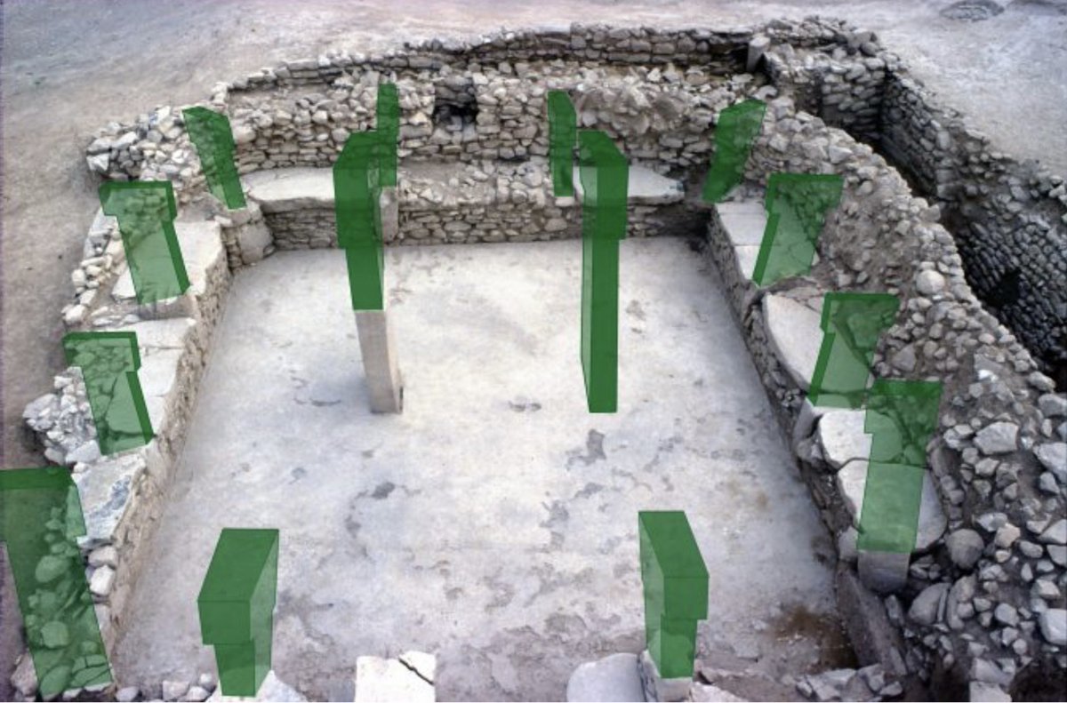
Images:
a. b. Gobekli Tepe.
c. d. Pueblo Bonito, Chaco Canyon.
Note: The author has personally visited Chaco, Gobekli, Shayp, Sogmatar, and the Rome catacombs.
Ralph Ellis


1
1
7
982
a. Tree-ring variability in one tree-trunk.
b. Balearic T-pillar in a circular temple.
c. Gobekli T-pillar in a circular temple.
RE

1
3
597
*** Tepi Temples — Arthurian Gospel Last Supper Tables ***
This is Nevali Cori in Eastern Anatolia: yet another of the many Tepi T-pillar Temples in that region. Again we see two central T-pillars surrounded by twelve smaller T-pillars, all of which are portrayed here as symbolic people, with arms and eyes.
I have long said that these many Anatolian T-pillar enclosures represent the zodiac, with symbolic Sun and Moon pillars surrounded by twelve smaller T-pillar constellations of the zodiac. I have also suggested that these temple enclosures are central components within a vast necropolis complex. This is where people brought their dead for a ceremonial Last Supper, before arranging a temporary burial, years of bodily decomposition, and subsequently taking the desiccated bones back home.
However, at Nevali Cori we see that all the circumferential T-pillars are symbolic people, complete with arms and eyes. So what we appear to have here, is the origins of the New Testament’s Last Supper Table and the Arthurian Round Table, which were all symbolic anthropomorphic zodiacs. In each case, we have the Sun and Moon at the center of a ring of twelve constellations, which were often portrayed as twelve disciples or twelve knights.
Nevali Cori reconstruction in the Edessa Museum.
x.com/archaiclens/st…
In which case, the tradition of a Last Supper ceremony, involving the Sun-King and Moon-Queen surrounded by twelve disciple-knight-constellations, appears to go back to the dawn of time - to the the very dawn of Western civilisation. Way back to a neolithic pre-pottery age, reputedly some 12,000 years ago. And yet the Gospel disciples and the Arthurian knights were playing the same roles at the same ceremonies, some 10,000 years later. And you can bet that the Knights Templar performed very similar ceremonies within their circular churches.
Any guesses where this same ancient ceremony is still being performed today?
Note 1:
My book The Grail Cypher explains that the Story of King Arthur, is a retelling of the story of King Jesus. It is the same story, just narrated in secular terms and deliberately reset into the 6th century.
Note 2:
Stonehenge is called Cor y Cewri meaning Circle of Giants or Chorus of Giants. Nevali Cori is also a circle, but I cannot find any linguistic links between the Welsh Cor and the Turkish Cori. Having said that, the Welsh Cor is likely to have been derived from the Latin Chorus and the Greek Khorus which refers to: "a round dance; dancing-place; band of dancers; company of persons in a play, under a leader, who take part in dialogue with the actors and sing their sentiments at intervals". Perhaps you can see here the linguistic link between a circle and a chorus, and the circular Henges and Tepis
Images:
a. Two images of Nevali Cori.
c. The Hamat Teverya Last Supper Table, owned by Jesus.
d. The Lady Mary zodiac, with the Sun and Moon (Jesus and Mary) surrounded by 12 disciple-knight-constellations.
Ralph Ellis


3
1
4
518
*** Ralph on Fairytale Symbolism ***
Ralph was talking to Judith on Nightflight recently, about the cosmic symbolism of fairytales. The secrets hidden within.
And then we drifted in the second hour, to the threat of Islam to modern Europe. A radical but interesting segue, there…!
youtube.com/watch?v=fFBMPQLV…
by
Ralph Ellis
1
1
4
818
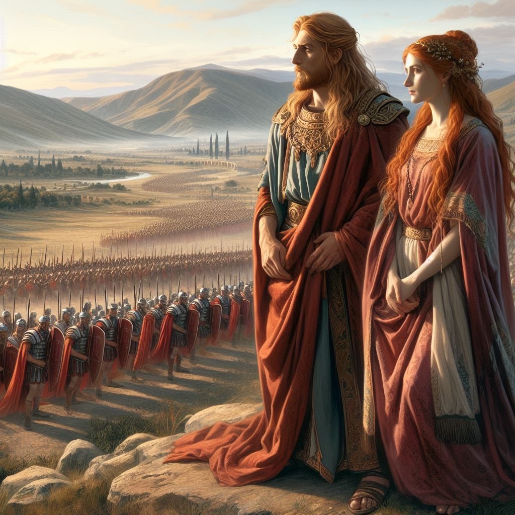
*** King Jesus Feeds his Legion of 5,000 men ***
In the last TwiX we saw that Jesus was the leader of the Jewish Revolt against Rome. A land-tax revolt, that spiralled out of control into a regional war. See previous TwiXes.
However, to combat the Roman presence in Judaea and Syria, King Izas-Jesus of Edessa would need a legion of his own, to throw the Romans out of the region. This was the very legion that defeated the Roman legion of Cestius in AD 66, at the start of the Jewish Revolt.
So Jesus recruited 5,000 men (a legion is about 5,000 men), and took them into the wilderness for a rousing pre-battle speech. Remember that the Egyptian False Prophet (EFP) did exactly the same, which is why I have identified the Egyptian (EFP) as being a derogatory name for Jesus-Izas.
Quote:
(The disciples said) we only have five loaves and two fishes ... yet there were five thousand men. And Jesus said: Make them sit down by fifties in a company. ... And they did eat, and were all filled: and there were twelve baskets of fragments. (Mt 14:14, Lu 9:16, Mk 18:19, Jn 6:11).
Within my Gnostic reinterpretation of the gospels, this ‘bread’ refers to knowledge (see Mark 7:27-28), while the ‘two fishes’ represent the two fish of the constellation of Pisces and therefore of the Great Month of Pisces. That is why there were twelve basket-constellations left over, after they had ‘eaten’ (consumed this knowledge). In reality, this was a teaching about astrology, and the millennial precession of the equinox. Jesus was a prince and king of the Great Month of Pisces, which began in AD 10, as we shall see in the next TwiX.
King Izas-Jesus was giving a speech to his own legion, just before the decisive battle with the Roman Legion of Cestius in AD 66, which started the Jewish Revolt. Which Jesus-Izas won, by the way. This is why immediately after the speech to his 5,000 strong legion, Jesus-Izas said to his assembled men:
Quote:
Jesus said to them all: If any man will come after me, let him deny himself, and take up his cross and follow me. For whosoever will save his life shall lose it: but whosoever will lose his life for my sake, the same shall save it. (Mt 16:24, Mk 8:19, Lu 9:23.)
What was the meaning of this ‘cross’? Jesus had not been crucified as yet, so the mention of a cross would have been utterly incomprehensible to these men. However, in Roman military parlance this made perfect sense. Ever since the reforms of General Marius, legionnaires had carried their kit on a cross - a furca - and were henceforth called Marius’ Mules.
So to King Izas-Jesus of Edessa’s legionaries this command was obvious - pick up your kit (on its cross) and follow me into battle. You will lose your life anyway, at some point in time, but if you lose your life today in this battle against the legion of Cestius, you will be saved in heaven. This was a truly rousing speech by a commander to his 5,000-strong army - to his legion.
Images:
a. An older King Jesus-Izas and Mary survey their legion of 5,000, before battle.
b. Legionnaires pick up their furca-crosses, to follow King Jesus-Izas.
by
Ralph Ellis

1
2
296
*** Ralph Ellis Books on Audio and Kindle ***
In previous TwiXes, we have begun to look at the life of the true historical Jesus, who was a prince and king of Edessa.
Readers are obviously intrigued, but looking for confirmation and references. Please be assured that all this information has been taken from orthodox historical sources, and analysed in a scholarly, dispassionate and agnostic fashion.
Yet despite my agnostic treatment of these early manuscripts, the conclusions I have reached are no less controversial. For the chronicles do all point towards the gospel Jesus being a real but largely unknown historical prince and king of Edessa. The reason for this historical lacuna (or vacuum) being that Rome (ie: Josephus Flavius) has deleted the Edessan monarchy from history. Were it not for the Syriac historians, we would know almost nothing about them, and Rome’s strategy of obfuscation and deletion would have succeeded.
So if you enjoy audio books, do join this continuing adventure with Google Play.
I chose Google Play, because Amazon Audible would not allow digital voices at the time, and Google’s production platform was far superior. The Google voice is so natural, you can hardly tell it is digital. I chose a soft, studious English male voice, for its worldwide acceptability.
Subsequently, Amazon Audible now allow digital voices and seem to have acquired a VERY similar production platform to Google. But Amazon will not allow the upload of Google audio files, despite the similar nature of their new production platform. And I am not doing all that work again just for Amazon, as each book took three or four weeks to turn into audio books.
The trouble being that 20% of my text is composed of archaic and foreign words, that the audio system did not know how to pronounce. So the system had to be taught the correct pronunciation, which it then refused to remember and apply to subsequent books in the four-part trilogy - an insane deficiency in the Google system. Each word had to be re-learned again and again. And the Google system was so new, that their engineers had no idea what I was taking about, most of the time.
You might ask why not use my own natural voice? The trouble being that I was guilty of too many umms and arrs, and small stumbles, which meant that each paragraph needed dozens of amendments to make the audio worth listening too. And to be honest, the Google voice was more clear and consistent than mine.
So do join us on Google Play, as we continue to explore the true historical history of the gospel story. The gospel story that details the tragic history of the Jewish Revolt against Rome, and the unsuccessful Edessan bid for the Throne of Rome.
Google Play Audio Books:
The King Jesus Trilogy, in four parts.
play.google.com/store/books/…
Amazon Ebooks and Paperbacks
The King Jesus Trilogy, in four parts.
amazon.com/dp/B09Q3H8H84
Apple ibook versions are also available for iPads.
The Apple eBook reader used to be far superior to Kindle. But the Apple sales effort was utterly useless, and the Kindle platform has greatly improved.
books.apple.com/.../jesus-ki…
by
Ralph Ellis.
1
2
188
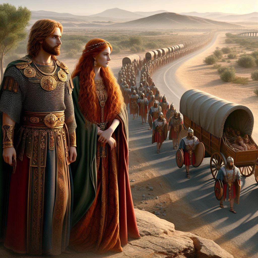
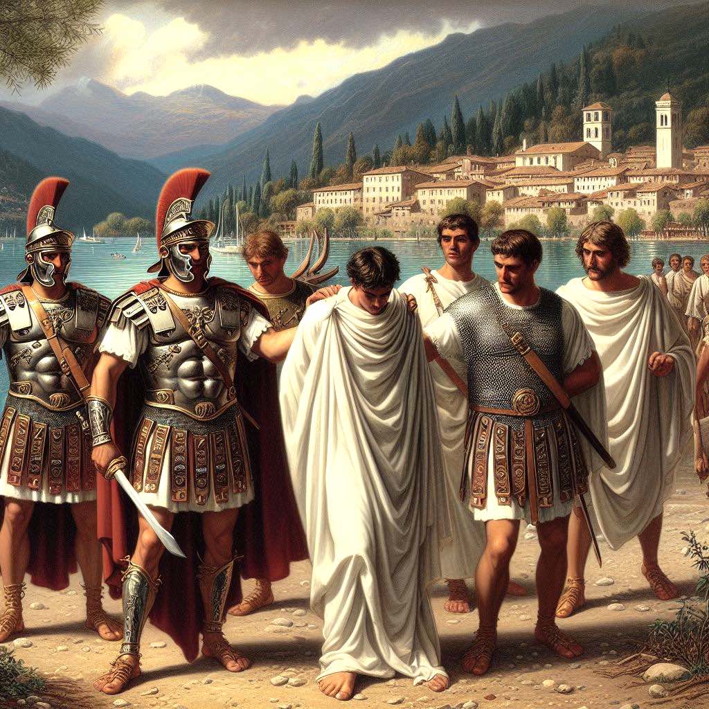
*** Jesus’ Tax Dispute with Rome ***
In previous TwiXes, we have seen how the gospel Jesus was a prince and king of Edessa, in northern Syria. And secondly, that he was the leader of the Jewish Revolt, which is why he was crucified by Rome, after that Revolt failed.
So what, according to biblical history, was the Jesus’ Jewish Revolt all about? The answer can be clearly seen in the Parable of the Vineyard Owner (Lu 20:9, Mk 12:1, Mt 21:33).
Quote:
And Jesus began to speak unto them by parables. A (landlord) planted a vineyard ... and let it out to farmer, and went into a far country. At the harvest he sent a servant to his tenant, that he might receive his rent. But they caught the servant, and beat him ... and beat another ... and another they killed. So what shall the lord of the vineyard do? He will destroy the wicked farmer, and will give the vineyard unto others (who will pay their rent on time).
So why is the gospel’s 'pauper prince of peace' upholding the rights of absentee landlords to kill their tenants, if they fail to pay their rent? The answer is that this is a parable, and thus purposely designed to withhold secret information. So the Church’s interpretation of this parable is hopelessly wrong. For the true answer, just replace ‘landlord’ with Edessan king, and replace ‘tenant’ with Romans.
Quote:
And Jesus began to speak unto them by parables. An Edessan king planted a vineyard (owned lands in Judaea) ... and let them out to the Romans, and went into a far country (went back to Edessa). At the harvest the king sent a servant to the Romans, that he might receive his rent. But they caught the servant, and beat him ... and beat another ... and another they killed. So what shall the Edessan king do? He will destroy those wicked Romans, and will rent out the lands of Judaea unto others (who will pay their rent on time).
Now we can see the true historical problem. The Romans were occupying Edessan lands in Judaea and Syria, and failing to pay the Edessan royalty any rent (tribute). Indeed, these terrible Roman tenants were so bad, they were demanding rent from the landlord. The cheek of it - what tenant has ever been so brazen?? So when the Edessan army goes down to Judaea, it will destroy those wicked Romans and the king will rent this land out to a people who WILL pay their rent.
This was the basis and the justification for the Jewish Revolt - it was primarily a tax dispute. The Romans were demanding tribute from Edessa, for cultivating and living on their own lands. And this was unacceptable to King Izas Manu, king of Edessa and Judaea, and so he went to war with Rome.
Which may not have been a wise decision, by the wise king.
Image:
Jesus-Izas and Mary observe yet more Romans invading Edessan lands.
by
Ralph Ellis
3
181
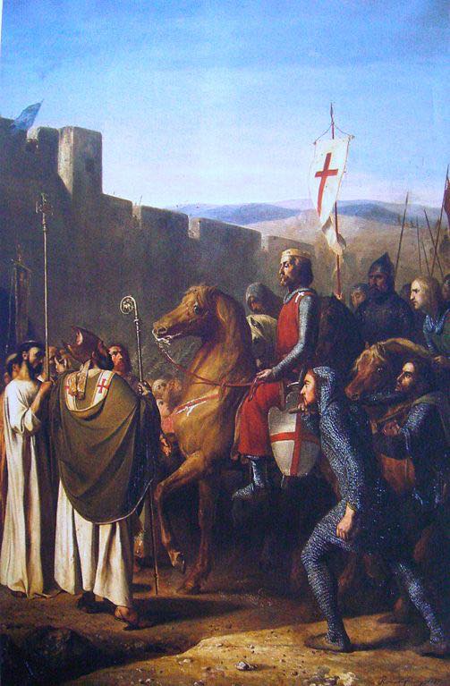
*** The First Crusade goes to Edessa ***
In previous TwiXes, we have seen it is highly likely that gospel events and characters were centered upon Edessa, in northern Syria. Edessa being a prosperous and influential kingdom (or principality), in the 1st century. See previous TwiXes.
Few people today know of the role of Edessa in the formation of Christianity, but that was not so a millennium ago. And we can see this in the history of Alfred the Great and the later Crusading era.
Count Baldwin of Boulogne (in Normandy) set off on the First Crusade in 1096, at the head of the Princes Crusade. But rather than going to liberate Jerusalem from Muslim subjugation and oppression, he firstly liberated Edessa instead. And in Edessa he was greeted by tears of joy by the people of this beleaguered Christian city. (Yes, the Crusades were organised to liberate the Christian East, from harsh Muslim oppression and subjugation.)
But why liberate Edessa first, a city that resided to the east of the Euphrates?
What was it about Edessa, that made it so special?
What was it about Edessa, that necessitated its deletion from history?
The answer has been explored in my previous TwiXes, and more fully explained in my book ‘Jesus, King of Edessa', which demonstrate that Jesus was indeed a 1st century Edessan prince and king. In which case, it is likely that Count Baldwin of Boulogne went to Edessa to discover more about this occult (or hidden) neo-biblical history.
And Count Baldwin must have been successful in his endeavours because 35 years later, just five years after the founding of the Knights Templar, a new history was devised in Normandy. This new chronicle told the history of another king, who seemed remarkably similar to the 1st century king of Edessa - the legend of King Arthur. There will be more TwiXes on the links between the Templars and Arthurian Legend later.
Once again we see that Edessa is central to the biblical story. And yes, this is one of the many secrets held by the Knights Templar.
Photo:
Count Baldwin is warmly greeted by the grateful people of Edessa.
by
Ralph Ellis
2
110
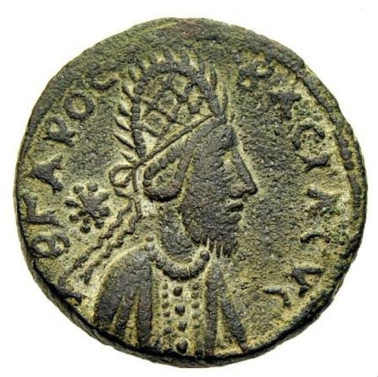
*** The Edessan Crown of Thorns ***
In the previous TwiX we saw how Jesus was likely to have been an Edessan prince and king, who became the King of the Jews. So would it surprise you to learn that the Edessan monarchy always wore a ceremonial plaited Crown of Thorns, just as Jesus was said to have worn at his crucifixion.
Quote:
And the soldiers platted a crown of thorns, and put it on (Jesus') head, and they put on him a purple robe. And said, Hail, King of the Jews! (John 19:2-3)
As you can see in the image below, this was not the traditional crown of brambles, which had been deceitfully designed to match the lowly artisan persona that the Church had crafted for their pauper Jesus. No, this was a royal mitre, in the fashion and tradition of the Parthian kings of Mesopotamia. And it was plaited and surmounted with thorns of some nature, just as the gospels recorded.
Yes, King Jesus Em-Manuel and King Izas Manu, wore the same Crown of Thorns.
Furthermore, the reason for placing a purple robe upon Jesus, was to highlight the purpose of the revolt he had been involved in (see Mark 15:7). For the purple robe was a symbol of the emperor of Rome.
The Edessan monarchy had started the Jewish Revolt as a stepping stone to sitting upon that very Throne of Rome. Emperor Nero was a dead man walking in AD 66, and was dead by AD 68 (at the hands of Epaphroditus, possibly Saul-Josephus’ translator and publisher).
So by AD 68 the Throne of Rome was empty for whoever could grasp it. Four contenders tried to become emperor during the contentious Year of Four Emperors, but in reality King Izas Manu VI of Edessa was a forgotten fifth contender for the Throne of Rome. King Izas Manu of Edessa was already the King of the Jews (we will see more evidence for this later), but wanted to become Emperor of Rome too.
If the truth was known, this was the Year of Five Emperors, and the biblical King Jesus EmManuel (King Izas Manu, king of Edessa and Judaea) was that fifth contender.
Image:
A later King Abgarus of Edessa wears the traditional Edessan crown of thorns - a crown that was worn by Edessan kings for centuries. Note the numismatic script had changed from Aramaic to Greek over the centuries.
by
Ralph Ellis
1
112
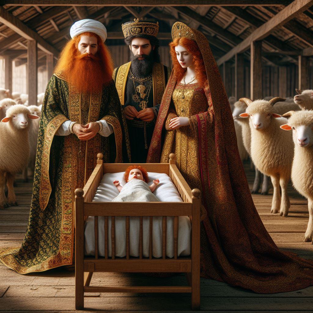
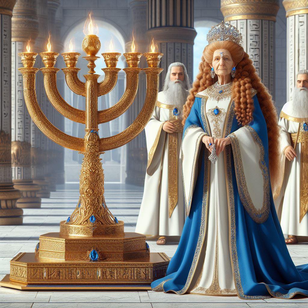
*** Jesus was a Prince and King of Edessa ***
In previous TwiXes, we have seen how gospel events and characters were closely linked to Edessa, the small kingdom in northern Syria ruled by King Abgarus and Queen Helena. It is demonstrable that John the Baptist and Saul-Paul were princes and ambassadors of Edessa. See the short link-list in the TwiX that follows this.
However, since Jesus was a cousin of John the Baptist, perhaps he too was a prince of Edessa. This was a small principality in northern Syria that was known in Greek as the Kingdom of Ourania. And in English this can translate into the ‘Kingdom of Heaven’, which is a familiar title in the gospels accounts.
The venerable historian Moses of Chorene, says that Edessa was founded as a principality in the early 1st century, by King Abgarus V. But if this is true, then where did the Edessan monarchy come from? Based upon multiple historical accounts, this is my summation.
In about 20 BC Emperor Augustus gave a diplomatic wife, called Thea Muse Ourania, to King Phraates IV of Parthia. She was the lost daughter of Queen Cleopatra, as mentioned (and feared) by Cicero, which is why she was such a presigeous wife for the king of all Parthia. However, after the death of King Phraates, Queen Thea Muse Ourania was thrown out of Parthia in AD 4, along with her son, 200 courtiers, 600 mounted archers, and half of the Persian treasury.
This exile ended with the founding of Edessa in northern Syria, and in my considered estimation a princely son born to these royal exiles kindled the Nativity Story. This is how the unlikely story of a lost king being born in lowly lodgings arose, for here was that very lost royal family in exile, with no grand palace in which to lay their head. The newly settled Edessan monarchy may well have begun in lowly surroundings, and they were most certainly deleted from history, for Josephus Flavius never mentions them.
In addition, do ask yourself why the Persian Magi, the Persian priests and kingmakers, would come to the birth of a lowly Jewish artisan bearing expensive gifts? The abbreviated story given to us in the gospel accounts is not credible. However, any son born to this powerful but exiled royal family, was a potential prince of all Persia and possibly of Egypt too. Of course the Persian Magi would come to honour his birth with gold, frankincense and myrrh.
And this royal family were indeed Jewish, as Queen Helena of Edessa converted to Nazarene Judaism according to the Talmud. It took seven years of initiation for this conversion into what I call Egypto-Judaism. This was an ancient form of Judaism that venerated the zodiac, as we shall see later. Hence the magnificent Jewish zodiacs in Galilee, and why the common Jewish greeting is Mazel Tov or ‘Good Constellation’. The final thing to note here, is the familiar name of this newborn royal prince of Edessa.
In the annals of history and gospels Jesus was called:
Gospels: King Iesous Em-Manuel of Judaea.
History: King Izas Manu of Edessa and Judaea.
Note: As we shall see in later TwiXes, the Edessan monarchs ruled Judaea in the AD 50s, owning the largest palace and tomb in Jerusalem, and furnishing the Temple of Jerusalem. Yes, Judaea was ruled by a proselyte Jewish queen of Edessa, and thus her son would have become the ‘King of the Jews’. Thus the historical Jesus was a real King of the Jews, rather than a pretend carpenter king.
Images:
a. Queen Helena of Edessa, plus two of the Magi, stand next to the infant King Izas-Jesus.
b. An older Queen Helena of Edessa stands near the huge menorah, that she donated to the Temple of Jerusalem.
These are the previous TwiXes on this topic.
Gospel events and characters were linked to Edessa.
See previous TwiXes.
by
Ralph Ellis
2
138
*** Saul-Josephus the Sukkah Tentmaker ***
In the last TwiX, we saw how Saul was an ambassador of Edessa, who later became a Judaean army commander working for the Jerusalem priesthood. (Later, he worked for the Romans.)
See previous TwiXes.
However, if Saul (Josephus) really had been an ambassador of the Edessan monarchy, then why is he called a tentmaker in Acts of the Apostles? I think this is a deliberate mistranslation of the Greek word skenopoios σκηνοποιος, to make Saul look like a humble artisan (just as they did with Jesus, likewise).
It is highly likely that the text originally said that Saul (Josephus) was a skenopegia σκηνοπηγια - a sukkah maker, or maker of tabernacles for the Festival of Tabernacles. A festival that is held on the 15th of Tisri (October).
Why is this relevant to the previous analysis and arguments that have been made? Because Queen Helena of Edessa-Adiabene was renowned for having the largest sukkah in Judaea. So once again we see a direct link between gospel events and the royal family of Edessa. The Tosefta says of this:
Quote:
A sukkah whose roof is higher than twenty cubits is invalid. (But) R. Judah (says) “... Helena’s sukkah was higher than twenty cubits, and no one said a thing against it.” They said to him: “That was because she was a woman ...” Judah said to them: “She had seven sons, all Torah scholars, and all of them dwelt in it!” (Tosefta Sukkah 1.1)
So Saul-Josephus was not a humble tentmaker, he was a fabricator of the royal sukkah, and therefore likely closely related to the Edessan monarchy. Again we see that Saul was an important and influential, closely linked to the royal court of Edessa. Which is why, when he was in prison, he was visited by procurators and the king and ‘queen’ of Judaea.
Gospel characters were important people, and the events that are described were momentous, as we shall see in later TwiXes. These were events that shook the Roman Empire, which is why these stories have been recited and debated for centuries and millennia.
Note also that the sons of Queen Helena were Judaic scholars, which will become important in this research. More on that later.
Image:
Queen Helena of Edessa in front of a grand Greco-Egyptian sukkah, for the Festival of Sukkot (the Feast of Tabernacles).
Books:
Please read the ‘King Jesus Trilogy’. An in-depth and fully referenced investigation into the historical roots of the gospel narrative.
The King Jesus Trilogy:
amazon.com/dp/B09Q3H8H84
by
Ralph Ellis

1
86
*** Biblical Saul-Josephus Persecutes Jesus ***
In the previous TwiX, we saw how the gospel Saul-Paul was actually a pseudonym for Josephus Flavius the historian. This may sound like a wild conjecture, but this conflation does actually explain many gospel conundrums, which is always a good sign for a novel theory. See the previous TwiX.
In Acts of the Apostles Saul-Paul was arresting the followers of Jesus, throwing them into prison and even killing them (Acts 8:3, 22:4-5, 26:11). But how was Saul, who was said to be a mere ‘tentmaker’, able to arrest these proto-Christians (at the command of the Jerusalem chief priests), and throw them into prison? How was Saul able to persecute Jesus in Damascus, long after Jesus was claimed to be dead? (See Acts 26:14-15.) None of this classical interpretation makes any sense.
The answer to this perennial conundrum can be explained by this same novel theory, that Saul was Josephus Flavius. Josephus Flavius was not only a prolific author, he was also a Judaean army commander in the mid AD 60s, in command of the region of Galilee. And his primary task during this time, as commanded by the Jerusalem priesthood, was to persecute and arrest a ‘dangerous rebel’ called Jesus*. Yes, both Saul and Josephus were persecuting a rebel called Jesus, and committing his followers into prison. Perhaps you can see why the conflation of Saul and Josephus makes so much sense.
Image:
Saul-Josephus in Roman-style armour, arresting the followers of Jesus*.
* This was Jesus of Gamala-Sapphias, the leader of 600 rebel fishermen. Perhaps you can see why I equate this historical character with the biblical Jesus, who became a fisher of men.
by
Ralph Ellis
2
76
*** Who was the Biblical Saul-Paul (of Edessa) ? ***
In my last Twix, we saw evidence that the New Testament Saul was an ambassador or prince of Edessa, who took the Edessan famine relief money to Jerusalem in about AD 50. This elevated position for Saul is not as preposterous as some may claim, because we know that Saul was a powerful individual. When Saul was imprisoned, for teachings incompatible with Judaism, he was visited by the great and the good of Judaea - by Procurator Felix, Procurator Festus, King Agrippa II and ‘Queen’ Berenike.
The great and the good of the Roman east do not go to see pauper tentmakers in prison, and ask for fat bribes, they go to see rich and influential people. So we can immediately see that the classical Church interpretation of these gospel events is being hugely economical with the truth. But if my novel claim is true, then who exactly was Saul in the historical record? I gave the answer to this way back in 1995, in my book ‘Jesus, Last of the Pharaohs’, which was updated and expanded in my book ‘King Jesus’.
It is an undeniable truth that the New Testament contains many hidden secrets and mysteries. And prime amongst them is the question of how have all these influential people like John, Saul, James, and Jesus, gone missing from the historical record? We have ample historical evidence for King Herod, Tetrarch Archelous, Tetrarch Antipas, Procurator Pontius Pilate, King Herod Agrippa II, High Priest Ananias, and Josephus Flavius - but these appears to be no John, Saul, James, or Jesus.
In truth it is highly likely that these people have been deliberately removed from history, because nobody in the Church wanted you to know who they really were. Historical reality did not conform with the established Christian narrative, and in many cases it was too embarrassing, so the identities of these people had to be covered up.
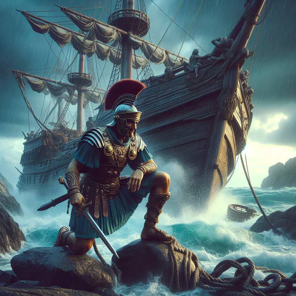
So who was Saul-Paul?
The answer is simple, as I have discovered some 20 points of commonality between two seemingly different characters. Including both of them being on the same prison ship that was shipwrecked on Malta, and both being taken to Naples and thence to Rome to see Emperor Nero. Again we see how powerful Saul must have been, for him to have been sent to plead his defence case before the emperor. And since not many prisoners from Judaea were sent to see the emperor, we might be able to use this event to trace Saul within the historical record.
So who is the historical character who mirrors the life and times of Saul so closely? Well, amazing as it might seem, that would be Josephus Flavius the historian. And perhaps you can now see why nobody would want a slimy quicksilver-quilled quisling like Josephus Flavius, being the primary author of the New Testament. And so everybody looked away, and turned the page. Yet these ‘two’ individuals even seemingly had the same ‘publisher’ - Epaphroditus.
And it confirms that the supposed ‘minor revolt’ revolt that Jesus was involved in (see Mark 15:7), was actually the great and tragic Jewish Revolt of AD 66-70.Note that because of this conflation, the gospel chronology has to change from AD 20s events, to AD 60s events. But this new chronology is fully supported by other out-of-place gospel events, as we shall see later.
This identification results in a remarkable and radical reevaluation of the gospel texts, but one that is fully supported by the history of the region. Indeed, just as with my re-evaluation of Kings David and Solomon (to be explained later), it will demonstrate that Jesus was a real historical monarch, rather than the pauper prince of peace that the priesthood have promoted. Instead, the historical Jesus was a very real Nazarene Jewish king of the Near East who started a revolt against Rome - to claim independence from Rome, and perhaps to even take the Throne of Rome for himself and his people.
You may think this novel endeavour - to somehow uncover a lost king of the Near East - to be impossible, because there was no such Jewish king in this region in this era. But that is not true. The reason you do not know about this king, is that Rome deliberately deleted him from history; a cancellation and eradication that accelerated in the post Medieval era. But I will present evidence later, that King Alfred the Great knew all about this king, as did the Knights Templar. In fact, this was one of the deep secrets that the Templars controlled - the very secret that the Catholic Church feared, and the very reason the Catholic Church destroyed the Templars on Friday October 13th 1307.
Which is why Friday 13th is unlucky for some.
AI Image:
a. Saul-Josephus crawls ashore on Malta, after his ship (named the Castor and Pollux) was wrecked. The reason for the Roman armour will become apparent later, which is why you will see many similar church illustrations of Saul in Roman armour.
b. Saul as a Roman centurion, Leipsig.
by
Ralph Ellis

2
94
*** Gospel Saul-Paul was an Ambassador of Edessa ***
In the last TwiX (post) we saw that John the Baptist was most definitely a prince and priest of Edessa - that small but influential Jewish kingdom that resided in northern Syria. But if John, who was a cousin of Jesus, was a prince of Edessa, then what about the rest of the disciples and apostles from the gospel narrative?
It would seem obvious that Saul-Paul was an Edessan ambassador, or even prince, and the conclusive evidence for this comes from Acts 11:28-30 which says:
Quote:
And there stood up one of them named Agabus, who declared ... that there would be great famine ... which came to pass in the days of Claudius Caesar. Then the disciples ... sent relief unto the brethren which dwelt in Judaea ... and sent it to the elders by the hands of Barnabas and Saul. (Acts 11:28-30)
This AD 50 famine was quite famous within the chronicles of these times, and the monarch who sent this famine relief money and food to Judaea was actually Queen Helena of Adiabene. Adiabene is said to have been a small Jewish kingdom near modern Mosul in Iraq. The kingdom that several apostles visited in the mid 1st century, according to Josephus Flavius, to convert them to Judaism.
But according to the Armenian chronicler, Moses of Chorene, Queen Helena was married to King Abgarus of Edessa. So it is pretty obvious that the Agabus in Acts of the Apostles, is actually a reference to King Abgarus of Edessa - because both of these reports connect this Abgarus-Agabus to the famine relief money that was sent to Judaea. So we do have an oblique mention of the Edessan monarchy within the gospel narrative, but the gospel authors have deliberately distorted the king’s name to obfuscate this troubling fact.
However, this short analysis gives us another very interesting connection, because according to Acts of the Apostles this royal famine relief money was taken to Jerusalem by the hands of Saul and Barnabas. And this assertion would make double sense, because Acts of the Apostles says that the apostles went from Antioch to Jerusalem, while the full name for Edessa was Antioch-Edessa.
So we can confidently assert that Saul-Paul must have been an ambassador of the Edessan royal family. An ambassador who, along with Barnabas, was entrusted with a large sum of monies from the Edessan treasury to purchase grain and olives in order to alleviate the famine in Judaea.
Images:
a. Saul-Josephus receives famine relief money, from King Abgarus and Queen Helena.
b. Queen Helena and her huge sukkah, for the Judaic Festival of Sukkot. A sukkah designed and built by Saul-Josephus.
Ralph

1
2
141
*** John the Baptist was a Prince of Edessa ***
This is an investigation into gospel history, from a completely secular historical perspective. Surprisingly perhaps for many readers, there is a reasonable amount of real history that dovetails with the gospel accounts. This is not often championed by Church historians, despite it supporting their gospel texts, because the real historical accounts of gospel events take us down a very different path to the one preached and championed by the Church.
For instance, real history appears to confirm the life and times of John the Baptist, but strongly suggests that he was a prince of Edessa. And this places a very different perspective upon the gospel narrative.
Edessa is a city in northern Syria (in Mesopotamia), which was once the prime nucleus of early Christianity. The gospel disciples Andrew and Thomas both came from Edessa, according to Foxe’s Book of Martyrs and to St Ephraem of Syria. Saul-Paul was also linked to Edessa, as we shall see in the next TwiX. But so too did John the Baptist come from Edessa, and we know this from the various accounts of his execution.
According to the history of the region, mostly penned by Josephus Flavius, back in the early 1st century Tetrarch Herod Antipas of Judaea was married to Princess Phasaelis of Petra. But Antipas wanted to divorce Phasaelis and marry Herodius, his brother’s wife. John the Baptist said this marriage was unlawful, and thereby managed to himself beheaded for his considered legal advice. A scenario that is somewhat similar to King Henry VIII’s marital complexities.
Back in Judaea, King Aretas of Petra was outraged about the treatment of his daughter by the Judaean Tetratch (a minor kinglet), so he sent an army to punish Herod Antipas. This minor conflict occurred somewhere in Judaea in the early AD 30s, and we have two complimentary but divergent accounts to study.
Josephus Flavius version:
Quote:
King Aretas made … war between him and Herod (Antipas) … and they raised armies on both sides, and prepared for war … and when they had joined battle, all of Herod’s army was destroyed by the treachery of some fugitives, who, though they were of the tetrarchy of Philip (Syria), joined with Aretas’s army. (Ant 18:5:1)
This is an interesting account, for why does Josephus not name the auxiliary troops from Syria? Josephus knew of all the events in this region and era, so why does he conceal the identity of these troops, and choose to denigrate them instead? The explosive answer to this question can be seen in the Syriac version of these very same events.
Moses of Chorene's version:
Quote:
King Abgarus (of Edessa) … allied himself with Aretas, king of Petra, and gave him some auxiliary troops … to make war upon Herod Antipas … Being sharply attacked, Herod’s troops were defeated, thanks to the help of the brave Edessans. As if by divine providence, vengeance was taken for the death of John the Baptist. (Moses of Chorene, History of Armenia, 2:29)
Ah, so now we know why Josephus was being so deflective. The denigrated ‘fugitives’ that Josephus would not name, were actually the army of King Abgarus V of Edessa. So here is a missing or deleted king of Mesopotamia -- the king and principality that Josephus will never mention, because Emperor Vespasian told him to delete them from history.
This is how a famous monarchy can indeed become deleted from history. History is written by the victors, and Emperor Vespasian did not want anyone to know about a minor (Jewish) king of the East who had precipitated and prosecuted a revolt against Rome. And so the Edessans became the forgotten monarchy, from the forgotten principality.
So why did the Edessan army come all the way down to Judaea, to battle against Herod Antipas?
We know why the army of King Aretas of Petra was there - it was because his daughter had been so badly treated by the Judaean tetrarch. But what of the Edessan army? Interestingly, Moses of Chorene alludes to the possibility that the army of King Abgarus was involved in this dispute because John the Baptist has been executed. It was “divine vengeance for the death of John the Baptist”. It would seem obvious that there was a close connection here, between John the Baptist and the Edessan monarchy. John was family, perhaps even a prince and priest of the Edessan monarchy.
The other interesting aspect of this analysis, is why no theologian or historian before myself, has highlighted this obvious connection. Theologians have studied these texts for centuries, but not a breath of a historical connection between John and Edessa has ever passed their lips. Even though this connection helps confirm that John the Baptist was a real historical character, and thereby giving credence to the rest of the gospel accounts. So why would that be? Why would theologians hide evidence that supports the gospel narrative?
The answer is that real history elevates John the Baptist to princely status. He is no longer a hermit in animal skins, he is a princely priest wearing the sacred leopard skin of a priest of the East (of Egypt). And since John was a cousin of Jesus, then perhaps Jesus should also be elevated to princely status, and again connected to Edessa.
This also shines the spotlight on the Kingdom of Edessa, and its close connections to Judaism and Jerusalem - with Queen Helena of Edessa-Adiabene becoming the defacto Queen of Judaea and the Queen of the Jews in the AD 50s. And the last thing that the Catholic Church would ever want, is anyone looking into the history and role of the influential city of Edessa.
See: “Jesus, King of Edessa”, 2023 edition.
amazon.co.uk/dp/B09Q3H8H84
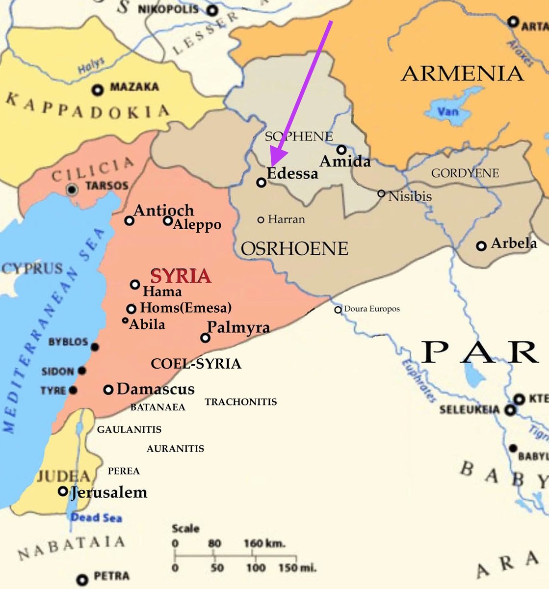
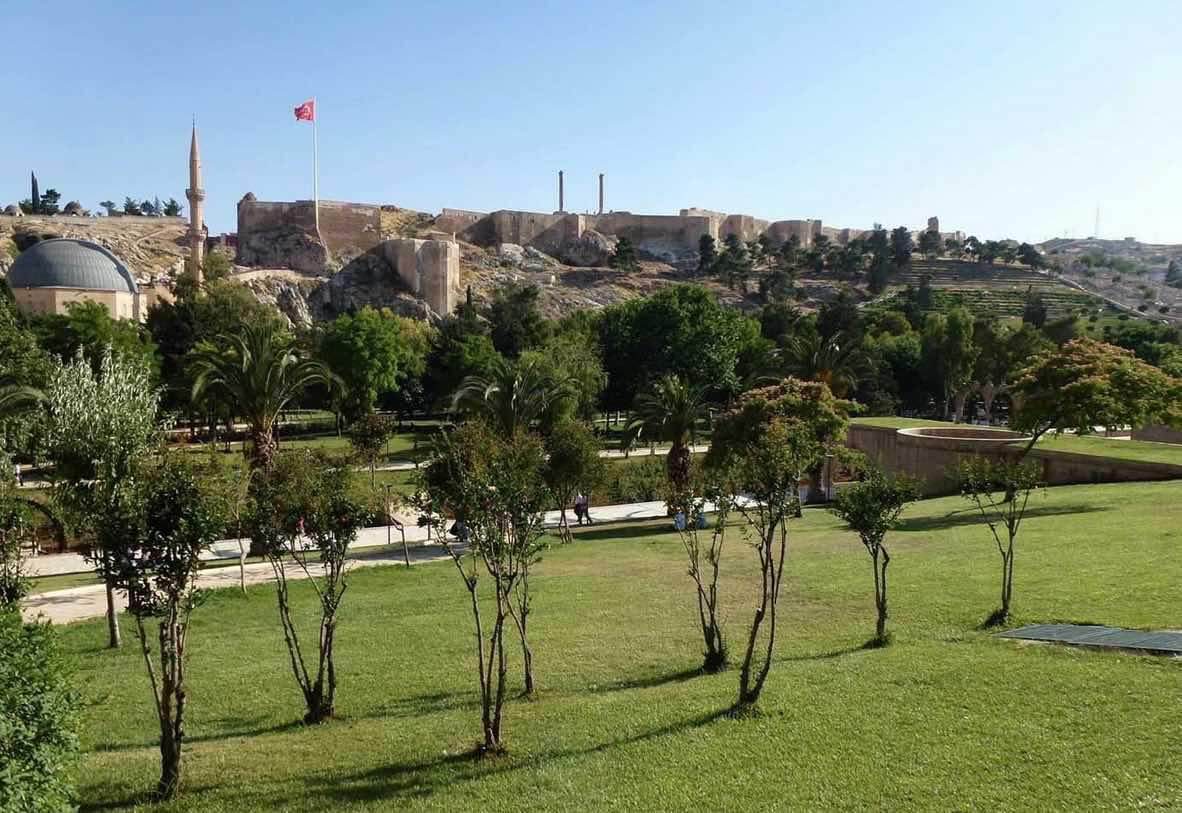
Image:
a. Map of Kingdom of Edessa in Mesopotamia.
b. The citadel of Edessa. Today it is called Sanlurfa.
c. Princely priests (Pharaoh Aye) wore animal skins.
d. The head of John the Baptist of Edessa, being brought to Herodias and Antipas.
Ralph Ellis


2
1
3
362