
Serving New Jersey's 21 counties with accurate weather forecasts, observations, severe weather alerts and analysis.
Joined January 2022
- Tweets 1,798
- Following 329
- Followers 337
- Likes 185
1,292 Photos and videos
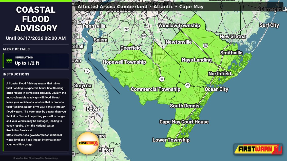


Coastal Flood Advisory has been issued for Cumberland, Atlantic, Cape May 2 more | Inundation: Up to 1/2 ft | Expires at 06/17/2026 02:00 AM.
26
Tuesday will feature low humidity and mostly sunny skies.
Humidity returns for Wednesday, with a chance of showers and even a thunderstorm, with a round possible around daybreak, and another toward evening.
Thursday is shaping up to be an interesting day. A powerful low pressure area will eject out of the Great Lakes region, and then head northeastward over Canada. This will swing a cold front through the area.
This system will also be deepening, and the pressure gradient will tighten considerably. 30-40 mph synoptically strong wind gusts are likely. The GFS even suggests gusts approaching wind advisory criteria of 46 mph. With foliage on the trees this time of the year, widespread, persistent gusts of this magnitude can cause tree-related issues.
Additionally, isolated to widely scattered showers and thunderstorms are possible, which will be very capable of taking the strong winds aloft to the surface in enhanced form. At issue is there may be limited aerial coverage of storms, unlike Ohio and Western PA which may get hit hard. Some guidance is dry throughout, dissipating any storms to our west, others have a little storm coverage north.
Guidance continues to suggest Thursday will be a hot day. Few days come to mind where temperatures were in the 90s and it was that windy.
Lower dew points settle in for Friday and Saturday, with the next system not until Monday when it may turn humid again. Saturday is a breezy day with low relative humidity. #NJ #NJWX #WX #Weather
1
69

Jun 15
Coastal Flood Advisory has been issued for Inland Sussex, Delaware Beaches, Atlantic 3 more | Inundation: Up to 1 ft | Expires at 06/16/2026 02:00 AM.
45
Jun 15
Coastal Flood Advisory has been issued for Middlesex, Western Monmouth, Eastern Monmouth | Inundation: Up to 1/2 ft | Expires at 06/16/2026 02:00 AM.
32
Jun 15
Coastal Flood Advisory has been issued for Kent, Cumberland | Inundation: Up to 1 ft | Expires at 06/16/2026 02:00 AM.
31
Jun 15
Coastal Flood Advisory has been issued for Ocean, Coastal Ocean | Inundation: Up to 1/2 ft | Expires at 06/16/2026 02:00 AM.
25
Jun 15
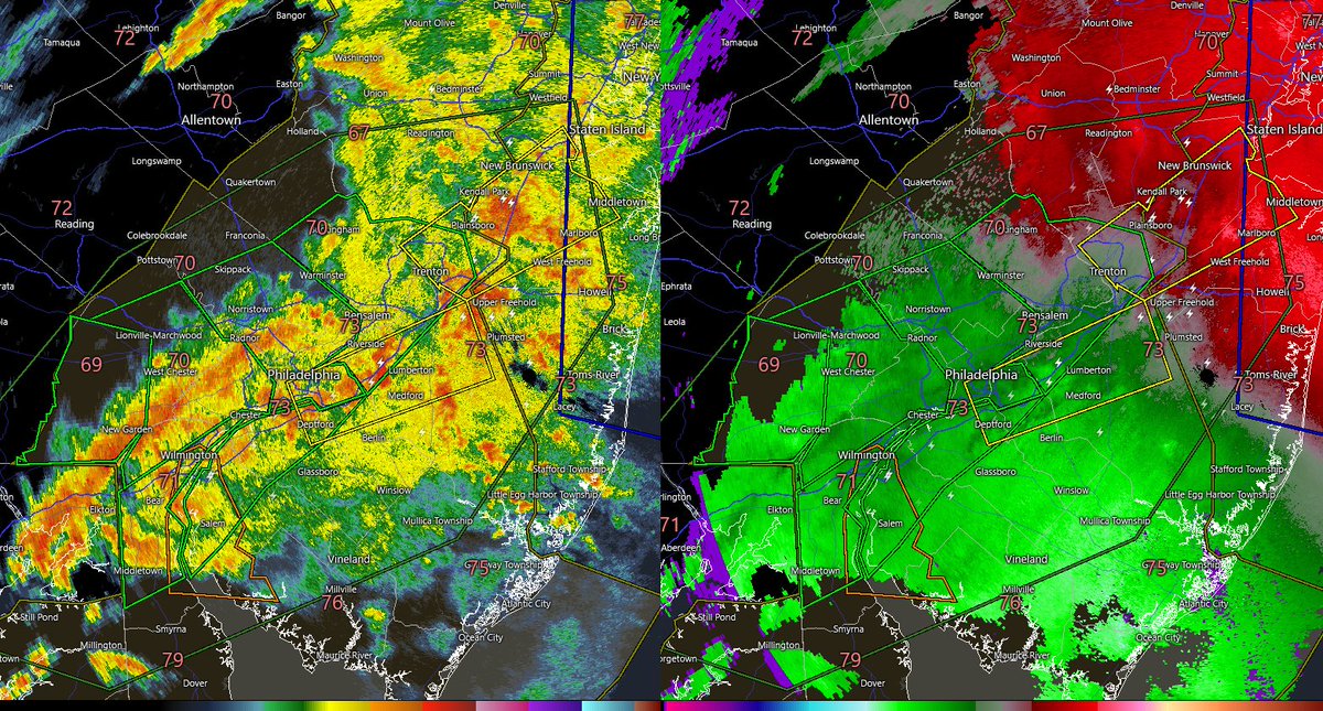
Radar estimated rainfall.
Gray is under an inch
Aqua blue is 1”
Purple is 2”
Bright Blue is 3”
Yellow is 4”
41
Jun 15
For today, humidity will drop after 8 a.m. and skies will clear, becoming mostly sunny.
Next chance of showers is on Wednesday, when humidity will return.
Thursday looks to be the next problematic day. A strong low pressure will eject northeast across Canada. This will strengthen the pressure gradient, leading to strong wind gusts of 30-40 mph.
Additionally, it will drag a cold front through that could have isolated to widely scattered, but severe t-storms. Storm coverage varies model to model, with an emphasis to our northwest, but we will still have to watch this closely. A lot of wind energy will exist just above the surface.
Friday now looks like things will dry out more quickly with lower humidity by days end. Saturday looks nice. #NJ #NJWX #WX #Weather
106
Jun 15
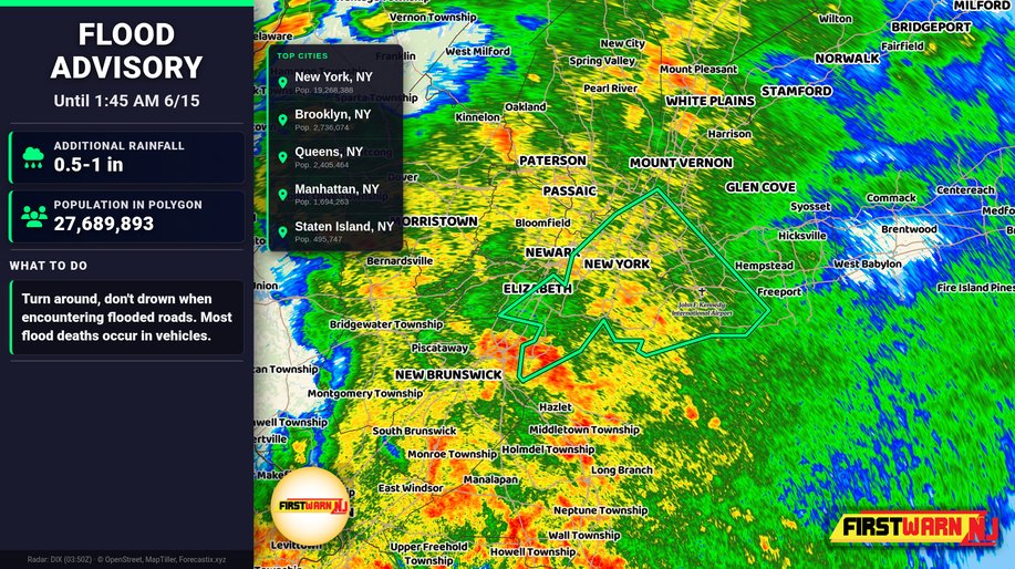
A Flood Advisory has been issued for Hudson, NJ, Union, NJ, Bronx, NY, Kings, NY, Nassau, NY, New York, NY, Queens, NY, Richmond, NY | Additional Amounts: 0.5-1 in | Expires at 1:45 AM 6/15.
59
Jun 15
A Flash Flood Warning has been issued for Burlington, NJ, Mercer, NJ, Middlesex, NJ, Monmouth, NJ, Ocean, NJ, Somerset, NJ counties | Amount Fallen: 0.5-1 in | Additional Amounts: 1-2 in | Expires at 3:45 AM 6/15.
70
Jun 15
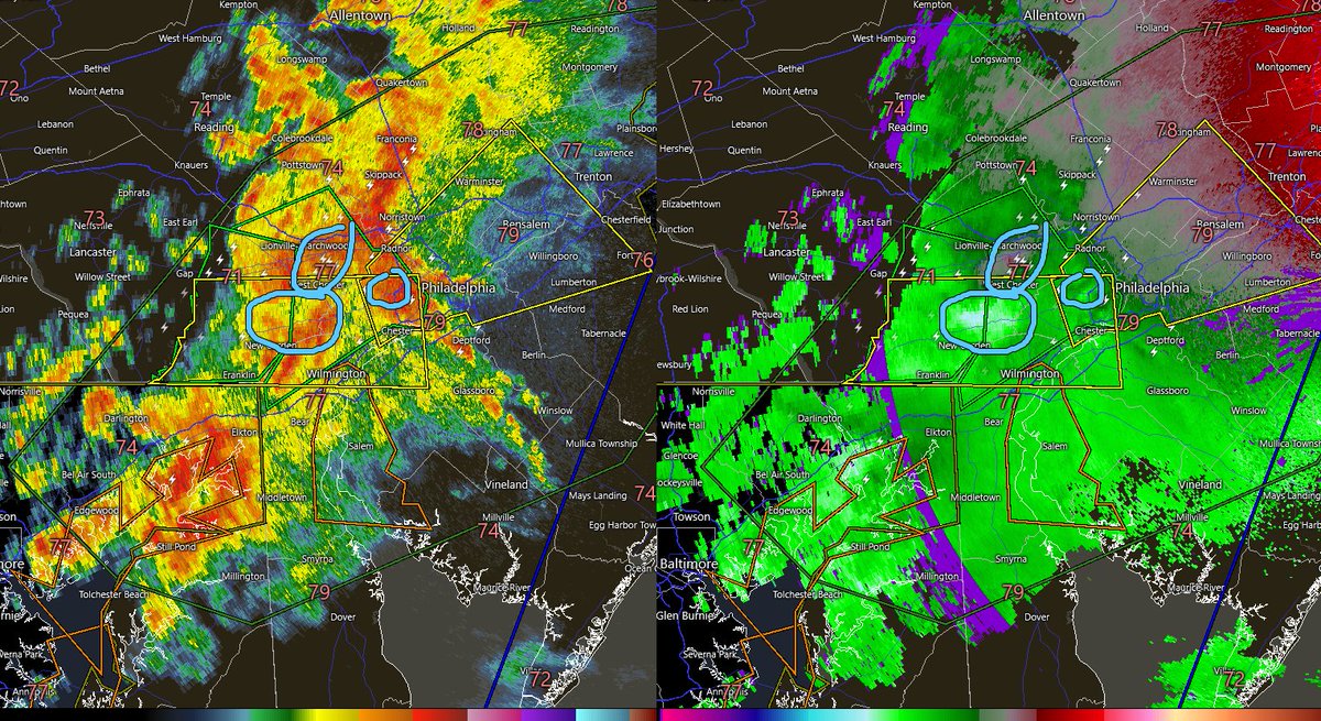
11:35 p.m. 6/14:
The meso-low continues its progression east-northeast. The severe threat is transitioning to a heavy rain event as the energy meets less unstable air. There have been a couple microburst signatures here and there, but the biggest impact appears to be heavy cells training over the same areas in and around I-95 where multiple flash flood warnings are now in effect. There has been a gradual downtick in DBZ, but still heavy rain.
Even though it has been dry recently, a quick 1-2 inches of rain in the urban corridor can overwhelm drainage infrastructure. #NJ #NJWX #Weather #WX
138
Jun 15
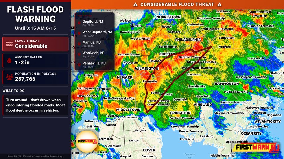
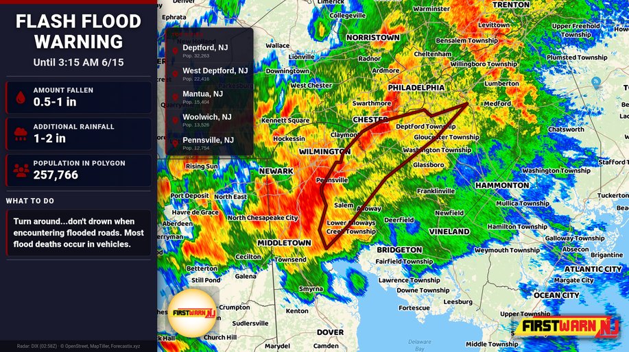
A CONSIDERABLE Flash Flood Warning has been issued for Camden, NJ, Gloucester, NJ, Salem, NJ counties | Amount Fallen: 1-2 in | Additional Amounts: 2-3 in | Expires at 3:15 AM 6/15.
71
Jun 15
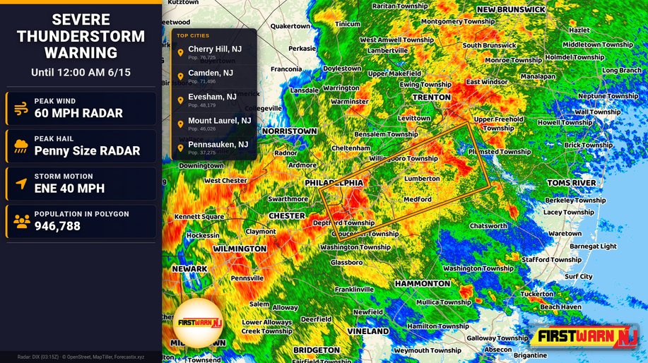
A Severe Thunderstorm Warning has been issued for Burlington, NJ, Camden, NJ, Gloucester, NJ, Philadelphia, PA. | Max Hail: 0.75 inches, Wind: 60 MPH | Expires at 12:00 AM 6/15.
1
68
Jun 15
A Flash Flood Warning has been issued for Camden, NJ, Gloucester, NJ, Salem, NJ counties | Amount Fallen: 0.5-1 in | Additional Amounts: 1-2 in | Expires at 3:15 AM 6/15.
1
73
Jun 15
A Severe Thunderstorm Warning has been issued for Burlington, NJ, Mercer, NJ, Middlesex, NJ, Monmouth, NJ, Bucks, PA. | Max Hail: 0.75 inches, Wind: 60 MPH | Torrential Rain: Occurring | Frequent Lightning: Occurring | Expires at 11:45 PM 6/14.
66
Jun 15
A Flash Flood Warning has been issued for Burlington, NJ, Camden, NJ, Mercer, NJ, Bucks, PA, Philadelphia, PA counties | Amount Fallen: 0.5-1 in | Additional Amounts: 1-2 in | Expires at 3:00 AM 6/15.
60
Jun 15
A Severe Thunderstorm Warning has been issued for Hunterdon, NJ, Mercer, NJ, Bucks, PA, Chester, PA, Delaware, PA, Montgomery, PA, Philadelphia, PA. | Max Hail: 0.75 inches, Wind: 60 MPH | Expires at 11:30 PM 6/14.

1
92
Jun 15
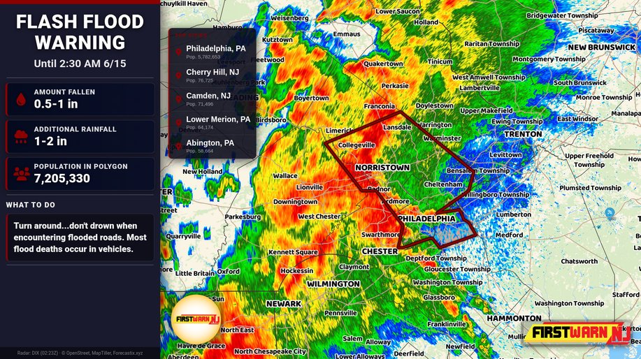
A Flash Flood Warning has been issued for Camden, NJ, Chester, PA, Delaware, PA, Montgomery, PA, Philadelphia, PA counties | Amount Fallen: 0.5-1 in | Additional Amounts: 1-2 in | Expires at 2:30 AM 6/15.
1
102
Jun 15
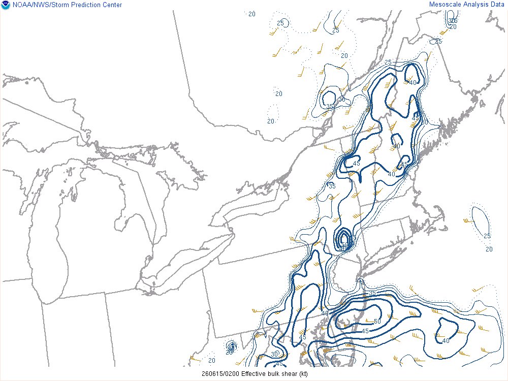
10:20 p.m. 6/14:
T-storms with heavy rainfall are moving east-northeast into the Philly and Trenton area. There has been a signature of damaging winds in Chester County with this feature, and every now and then brief rotation.
Wind shear and instability is starting to increase as the mesolow treks east-northeast, and gets closer, as depicted in the latest mesoscale analysis. Dewpoints are back to being near 70 degrees south of I-195 with a quick bump in moisture. #NJ #NJWX #WX #Weather

1
179