
Tracking weather in the Tri-Cities. We are the Tri Cities first warning when severe weather strikes. Partnered with @etnwxnetwork
Joined August 2020
- Tweets 15,588
- Following 170
- Followers 898
- Likes 119
13,667 Photos and videos
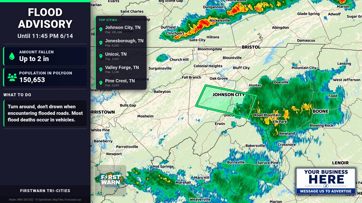


Flood Advisory for Carter, Unicoi, and Washington, TN until 11:45 PM 6/14. Urban & small stream flooding possible with heavy rain. Turn around, don’t drown—avoid flooded roads and never drive through water.
66
Special Weather Statement for Hawkins, Sullivan, & Others until 6:00 PM 6/14. Wind gusts up to 40 mph may knock down tree limbs and blow around unsecured objects. If outdoors, seek shelter inside a building.
39
Special Weather Statement for Buchanan, McDowell & Wyoming until 2:45 PM 6/14. Wind gusts up to 40 mph and pea-size hail possible with strong storms. Radar indicated. If outdoors, seek shelter inside a building.
34
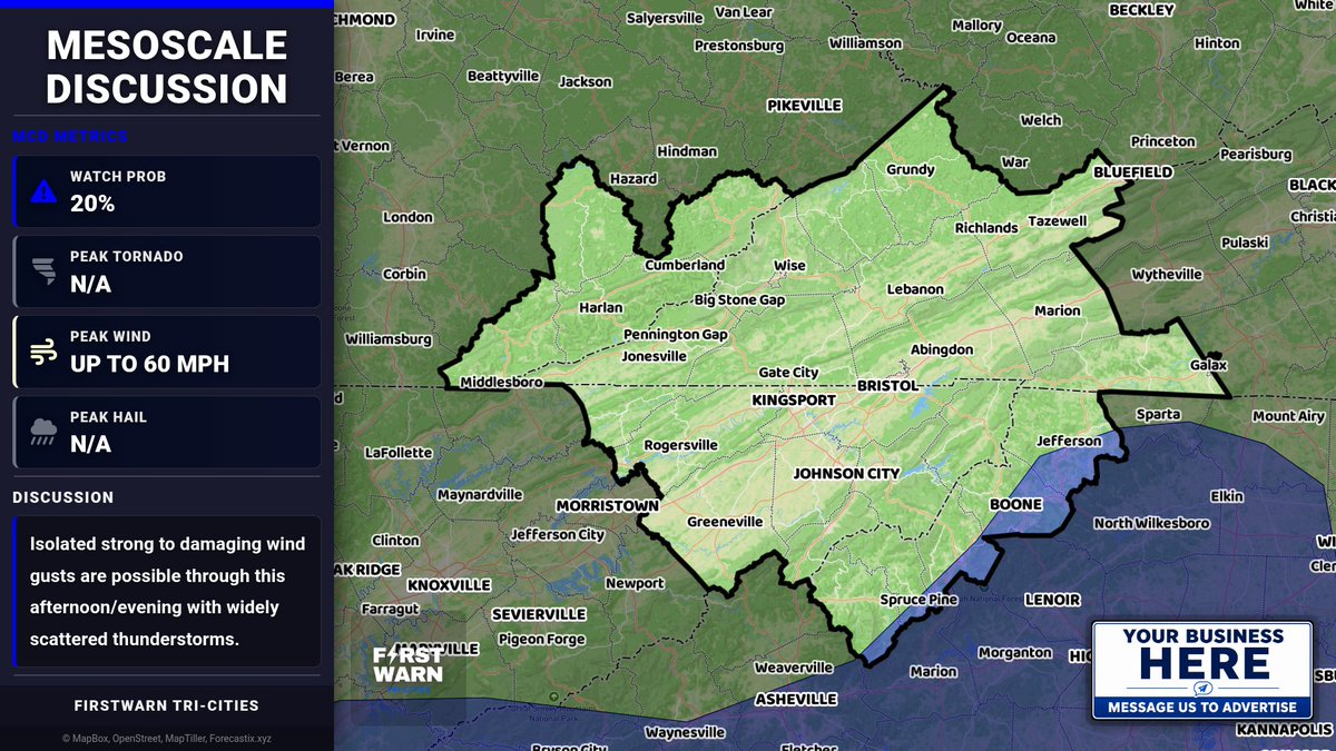
Mesoscale Discussion — Portions of the Southeast into western NC. Atmospheric setup supports widely scattered thunderstorms with isolated strong to damaging wind gusts possible through this afternoon/evening.
32
Special Weather Statement for Ashe and Wilkes until 1:45 PM 6/14. Wind gusts up to 40 mph possible, with radar-indicated strong thunderstorm. Gusty winds may knock down tree limbs and blow unsecured objects. Seek shelter indoors if outdoors.
26

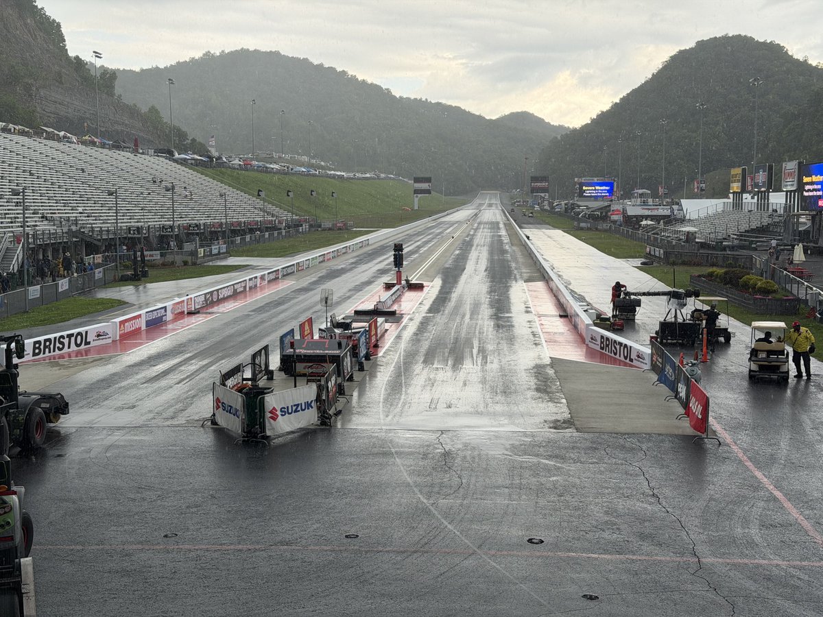
RACING UPDATE: Weather rolled in during RD 1 of PSM and we are on hold at the Super Grip #ThunderValleyNats.
Stay tuned for further updates from @BristolDragway.
1
17
68
3,486
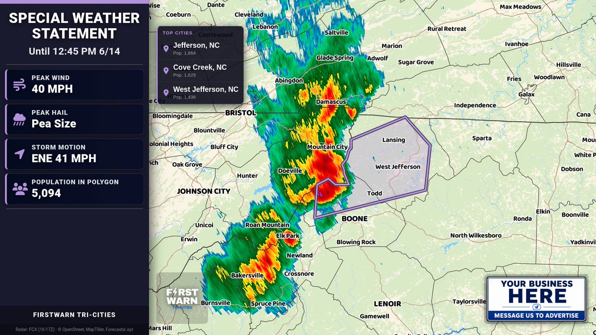
Special Weather Statement for Ashe & Watauga until 12:45 PM 6/14. Wind gusts up to 40 mph possible. Radar indicated. Gusts may knock down tree limbs and blow around unsecured objects. If outdoors, seek shelter inside.
32
Special Weather Statement for Smyth & Wythe until 7:15 PM 6/12. Wind gusts up to 40 mph and pea-size hail possible. Strong storms may cause downed limbs and brief flooding/standing water. If outdoors, seek shelter indoors; slow down.
48
Special Weather Statement for Grayson and Carroll until 7:15 PM 6/12. Wind gusts up to 40 mph and pea-size hail possible. Locally heavy rain may cause reduced vis and ponding/standing water. If outdoors, seek shelter inside. Slow down.
45
Special Weather Statement for Tazewell, Smyth, Bland, and Wythe until 6:45 PM 6/12. Wind gusts up to 40 mph and pea-size hail possible. Heavy rain may cause reduced vis and ponding/poor drainage flooding. Seek shelter indoors; slow down.
1
44
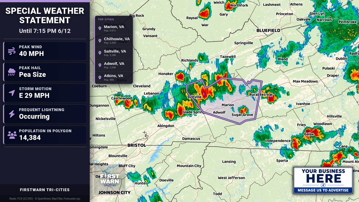
Special Weather Statement for Russell & Washington until 7:00 PM 6/12. Strong storms may bring wind gusts up to 40 mph and pea-size hail. Gusty winds may knock down limbs. Lightning is occurring—seek shelter indoors/vehicle.
35
Special Weather Statement for Buchanan and McDowell until 7:30 PM 6/12. Locally heavy rain (1-2.5") may cause brief high water in low-lying areas. Avoid flooded roads; don’t drive into water—depth may be too great.
24
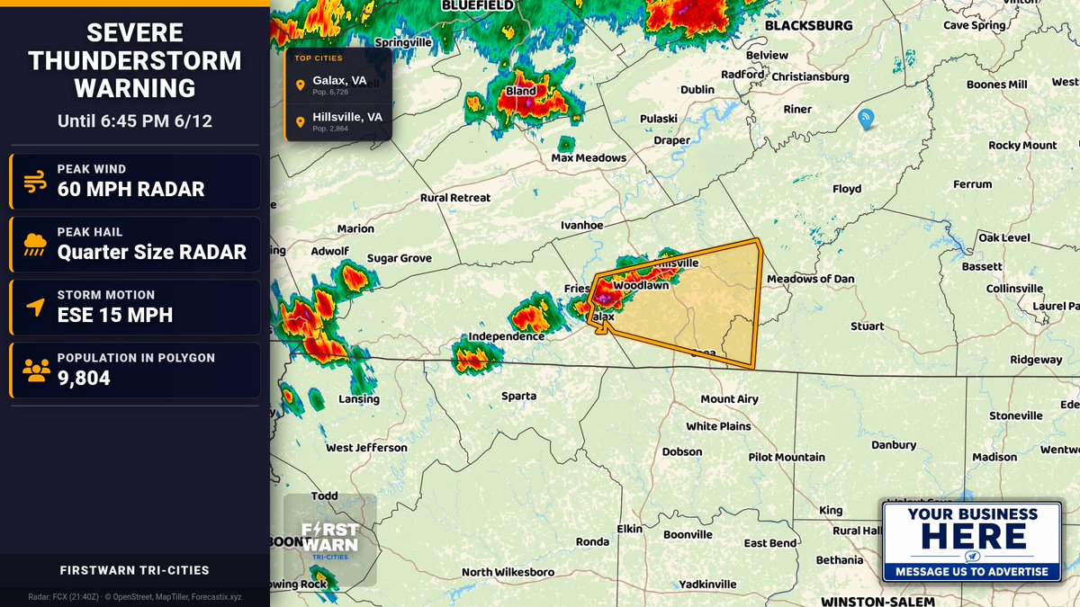
Severe Thunderstorm Warning for Carroll, VA & Others until 6:45 PM EDT. 60 mph wind gusts and 1.0 in hail possible. Radar-indicated storm near Galax moving E. Move to interior room lowest floor; stay away from windows.
24
Special Weather Statement for Ashe, Smyth, and Grayson until 6:30 PM 6/12. Wind gusts up to 40 mph and pea-size hail possible. Locally heavy rain may cause reduced vis and minor flooding. If outdoors, seek shelter inside; slow down.
22
Special Weather Statement for Grayson and Carroll until 6:15 PM 6/12. Wind gusts up to 40 mph and pea-size hail possible. Strong storms may cause brief heavy rain, reduced vis, and ponding/poor drainage flooding. Seek shelter indoors; slow down.
28
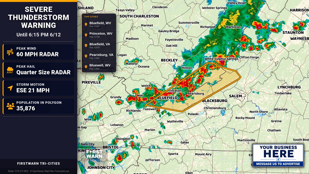
Severe Thunderstorm Warning for Alleghany, VA & Others until 6:15 PM EDT. 60 mph winds and 1.0" hail possible. Heavy rain may cause ponding/poor visibility. Move to an interior room on lowest floor; stay away from windows.
24
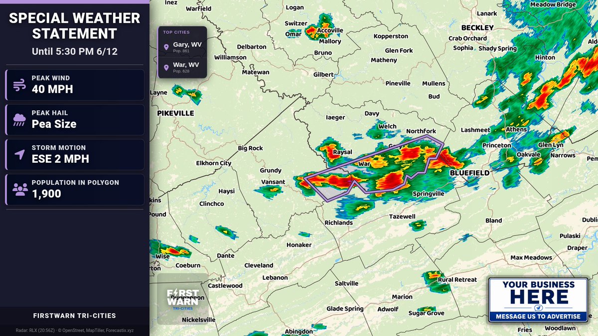
Special Weather Statement for Buchanan & McDowell until 5:30 PM 6/12. Wind gusts up to 40 mph and pea-size hail possible. Storms nearly stationary. If outdoors, seek shelter inside a building.
30
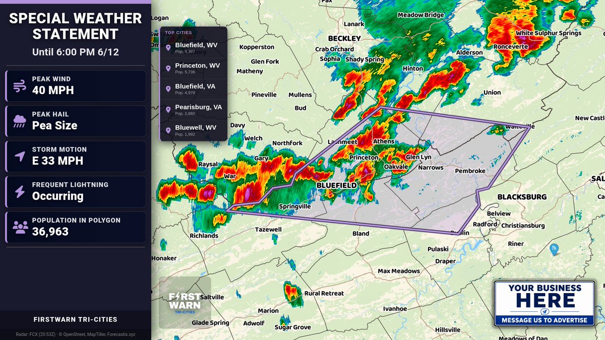
Special Weather Statement for Tazewell, Bland, Giles, Pulaski, Craig, Mercer, Summers, Monroe until 6:00 PM 6/12. Wind gusts up to 40 mph and pea-size hail. Heavy rain may cause ponding/road flooding. Seek shelter indoors; slow down.
26
Mesoscale Discussion — West Virginia, Virginia & Maryland. Storms producing locally damaging gusts may increase in coverage over the next several hours, with continued wind potential across much of Virginia and parts of Maryland.

94
Special Weather Statement for Sullivan, Johnson, NW Carter until 5:15 PM 6/12. Wind gusts up to 40 mph possible. Frequent lightning. Gusts may knock down limbs and blow unsecured items. If outdoors, seek shelter inside; avoid windows.

1
52