
Joined July 2011
- Tweets 68,413
- Following 48
- Followers 34,674
- Likes 2,140
61,019 Photos and videos


Dan Henry retweeted
(7:49pm) Significant Heavy rain is falling in the storm near Athens. Multiple gauges have reported up to 4 inches in the last hour. Even spots that aren't typically trouble spots may see issues. Stay off the roads if possible. #TXwx
2
1
72
Dan Henry retweeted
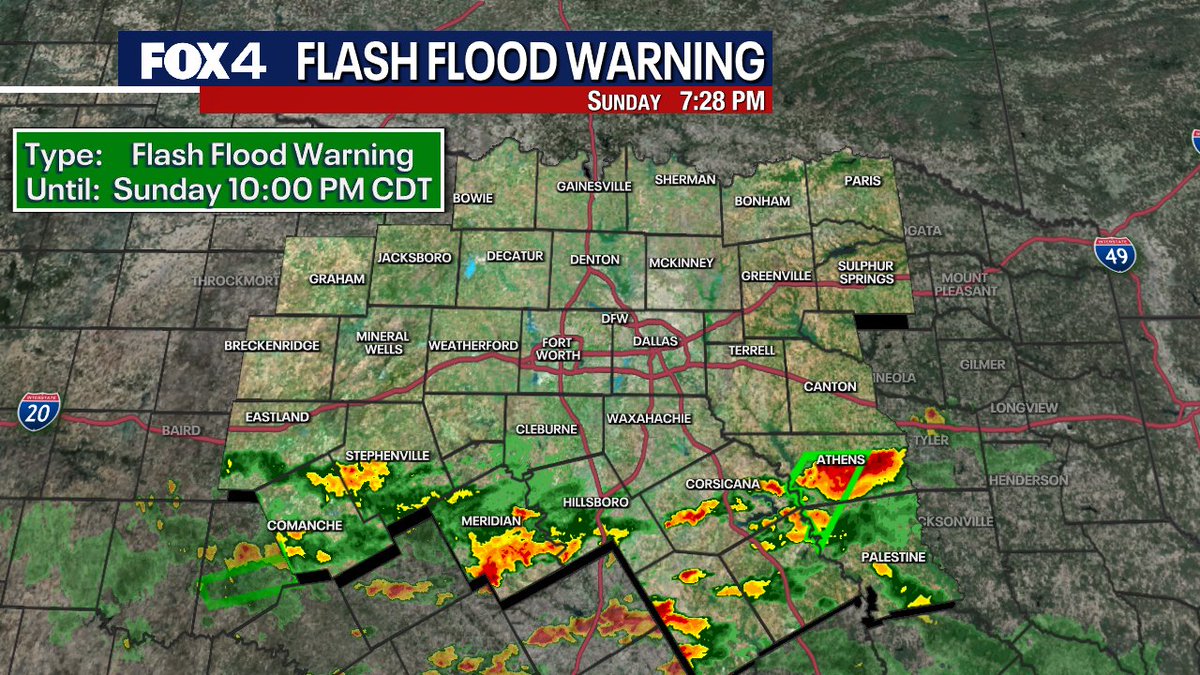
(7:29PM) FLASH FLOOD WARNING issued for ANDERSON and HENDERSON counties. Heavy rain has fallen, and rainfall rates exceeding 3 in/hr are present in this storm. Heavy rain will lead to flooding. DO NOT CROSS FLOODED ROADS! #TXwx

2
303
A Flash Flood Warning has been issued for parts of the Fox 4 Weather viewing area. #fox4weather
1
231
Dan Henry retweeted
(7:17pm) a FLOOD ADVISORY has been issued for ANDERSON, FREESTONE, HENDERSON, and NAVARRO counties through 9:30pm. Heavy rain has fallen and more is on the way. Flooding may begin soon. DO NOT CROSS FLOODED ROADS #TXwx
3
1
360
Dan Henry retweeted
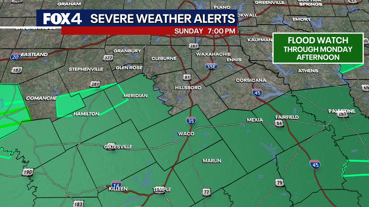
(7pm) The National Weather Service has extended the FLOOD WATCH to include parts of Bosque, Hamilton, and Freestone counties through Monday afternoon. Highest flooding risk will likely be closer to Waco, but we will need to monitor the threat overnight. #TXwx
3
3
1,883
Dan Henry retweeted
(6:24pm) FLOOD ADVISORY posted for Comanche, Erath, Hamilton and Bosque counties through 9:15pm. Heavy rain has fallen and more is expected to fall. Flooding may begin shortly. DO NOT CROSS FLOODED ROADS! #TXwx

4
2
2,128
Dan Henry retweeted
(5:58PM) Storms are clustering over Comanche, Hamilton, Bosque and Hill counties. These will have frequent lightning, gusty winds, and could lead to some flooding. Use caution on area roads and avoid low water crossings.
2
3
543
Dan Henry retweeted
(4:29PM) Storms are starting to redevelop S. of the Metroplex. These will be capable of lightning, heavy rain, and potentially some gusty winds. This is why it's a good thing the storms moved through in the morning. If they didn't this would be developing over the Metroplex #TXwx
2
5
777
Dan Henry retweeted
GREAT news for anyone at the first #FIFAWorldCup match at Dallas Stadium today. Thanks to the morning storms, we are quiet on radar as we wind down the last minutes to kickoff! We may see a few isolated storms develop after the match, but likely south of DFW. #TXwx
3
3
957
Dan Henry retweeted
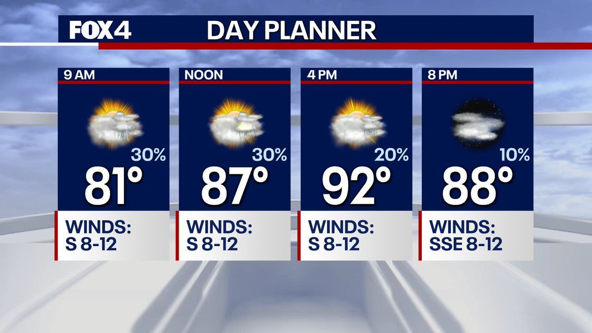
[9:25AM] Showers are moving over AT&T/Dallas Stadium this morning. This round will be in and out quickly and this system continues to the southeast! We are Live on Fox Local with a closer look now!
3
14
9,462
Dan Henry retweeted
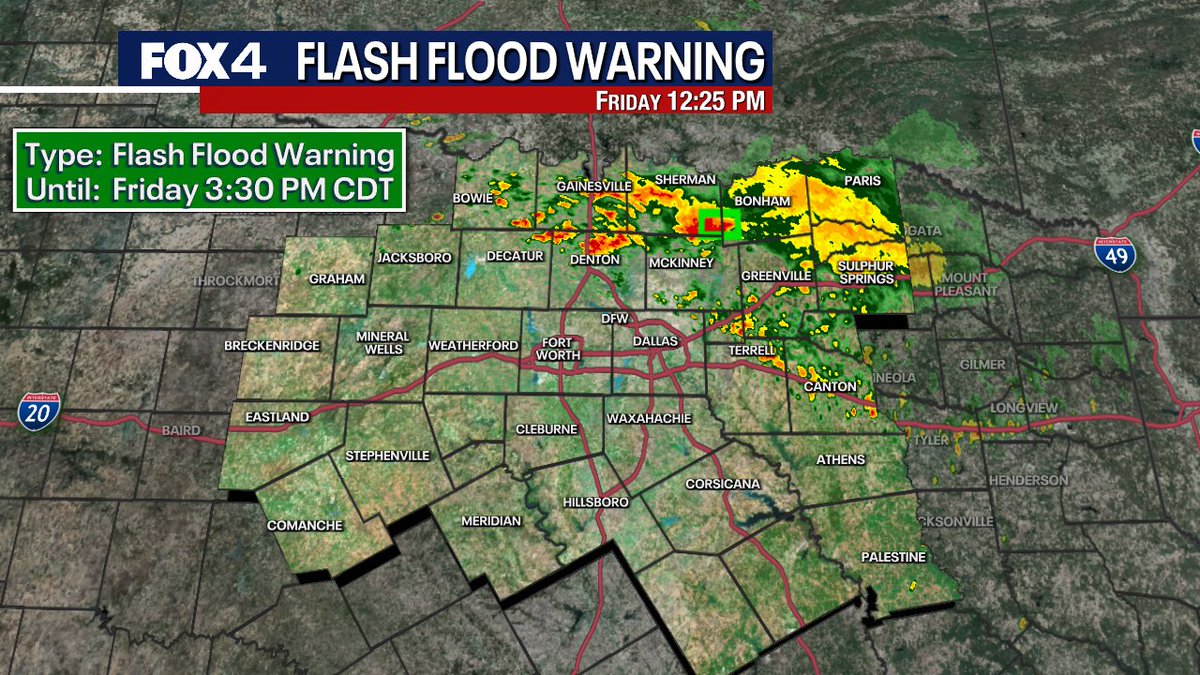
[7:40AM] A FLOOD ADVISORY has been issued for portions of Grayson and Fannin Counties until 9:15AM. Over 2 inches of rain have already fallen in a few spots along the Red River, and more is moving in. Do not attempt to drive through flooded roadways. Be safe!

4
7
2,203
Dan Henry retweeted
[4:10am] A line of thunderstorms is diving south through Oklahoma. This system is expected to move into our Red River Counties over the next hour. These are sub-severe, but heavy downpours and frequent lightning can be expected.
1
2
12
1,175
Dan Henry retweeted
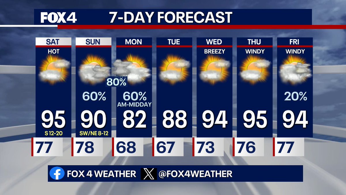
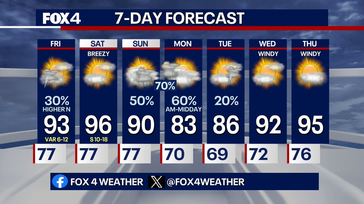
7 DAY FORECAST: An overnight complex of showers and storms will move in from Oklahoma, bringing storm chances for Sunday. Gusty winds, lightning, and heavy rain will be possible. Heaviest rain chances are overnight into Monday with a cool-down on the way! #TXwx

2
4
936
Dan Henry retweeted

Jun 13
Changes are moving in over the next 72 hours! Today it's still hot and breezy, but Sunday brings a chance for rain and storms, followed by a pretty significant cooldown on Monday. Here's the latest:

1
8
1,031

Jun 13
Partly sunny Saturday with heat indexes over 100. Scattered storms return Sunday ahead of an approaching front. A surge of tropical moisture will lead to more widespread rain and storm Sunday night into Monday AM. The front will also take a bite out of the heat Monday.
1
8
1,037
Dan Henry retweeted

Jun 12
TRACKER TOTALS: Today's rainfall was quite hit-or-miss in the DFW area, with many of our Airports reporting none. As you can see though, some of our Weather Trackers got hammered! 4 inches near Whitewright! What did you see? #TXwx
3
5
2,291
Dan Henry retweeted
Jun 12
(5:08PM) Scattered storms have moved away from the Metroplex, but are still firing along an outflow boundary from Stephenville-Meridian-Mexia. Activity will continue to shift south this evening and eventually fall apart as we lose day time heating. No issues for plans in DFW!
1
3
4
1,971
Dan Henry retweeted
Jun 12
(2:54pm) Good news! The storms that have been impacting some of the #FIFAWorldCup watch parties are moving south and out of the immediate Metroplex. Heaviest rain will now likely be south of I-20. Currently, theres a cluster near Jacksboro, and in Ellis/Navarro co. #TXwx
1
3
2
770