
Joined July 2024
- Tweets 2,924
- Following 769
- Followers 398
- Likes 2,854
1,401 Photos and videos


🚨⚡Primary threats tomorrow: Strong-to-Violent tornadoes (EF3 ), large hail (2" ), and damaging wind gusts (75 mph). Stay tuned for any updates throughout the day! #wxtwitter #severewx
44
⚠️ELEVATED TORNADO RISK:
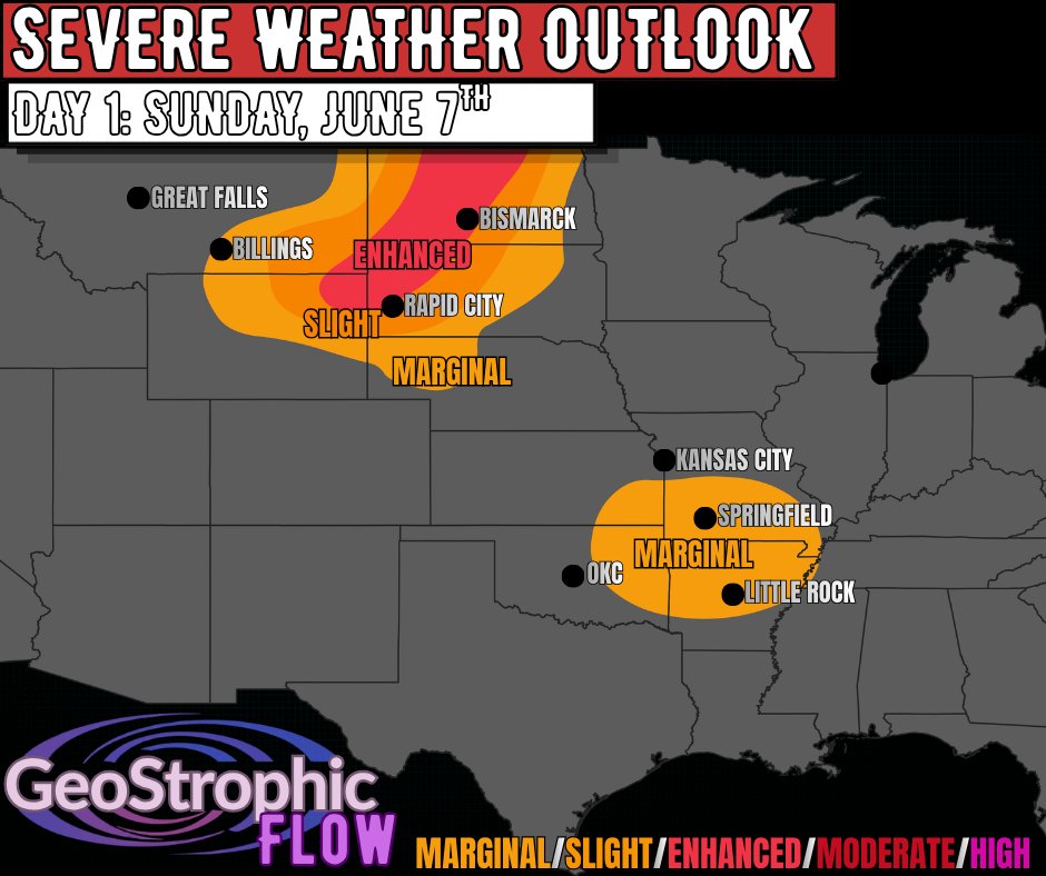
Tomorrow's severe weather risk will consist of an elevated tornado threat across Northern Illinois/Indiana. The combination of strong deep-layer wind shear, a strong low-level jet, and strong instability will support an INCREASED risk for strong-to-violent tornadoes (EF3 ). Tomorrow is going to be a very volatile severe weather day so make sure to have a plan in place & have several ways to receive critical weather alerts when they are issued! #wxtwitter
1
43

Jun 15
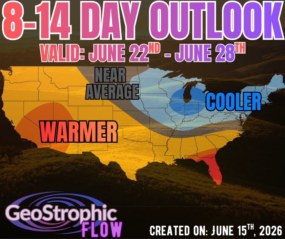
The Upper Midwest/Northeast will be in for a COOLER start to Summer 2026 with BELOW AVERAGE temperatures expected from June 22nd - June 28th! The summer solstice is almost here!
1
1
24
Jun 15
🟠⚡We have a day 4 SLIGHT RISK for severe weather across the Mid-Atlantic for Thursday, June 18th. This will be in response to a cold front passing through the region. Exact timing/details are TBD so stay tuned! #wxtwitter #severewx
1
1
85
Jun 15
🚨Our next chance for some substantial severe weather will be Wednesday afternoon/evening across the Great Plains, Mississippi Valley, and Great Lakes region. All severe weather hazards including destructive supercells capable of producing large hail (2" ), damaging wind gusts (75 mph), and strong-to-violent tornadoes (EF3 ) will be possible. Now is the time to prepare and make sure to have a plan in place! #wxtwitter
1
2
68
Jun 13
🚨⚡Destructive supercells capable of ALL hazards including large hail (2" ), damaging wind gusts (75 mph), and strong tornadoes (EF2 ) will be possible through this evening. As the evening progresses storms will begin to grow upscale resulting in an increased threat for damaging straight-line winds. Stay weather AWARE and make sure to have multiple ways to receive critical weather alerts! #wxtwitter
1
2
21
Jun 13
A wave of low-pressure developing along a frontal boundary will result in a round of severe weather from the Great Plains into the Mid-Mississippi Valley through this evening. As a result, we have an ENHANCED RISK for severe weather from eastern Kansas, northern Oklahoma, and extending eastward into Missouri. Today's threats will consist of damaging wind gusts (75 mph), large hail (2" ) and a FEW tornadoes (EF2 possible). Stay tuned for a more detailed analysis of today's severe weather threat coming soon! #wxtwitter
1
3
25
Jun 12
Scattered Severe Thunderstorms Expected Across the Mid-Atlantic/Northeas... youtu.be/9Q-c6WBAMp4?si=Y3JJ… via @YouTube
1
1
7
Jun 11
A confirmed tornado is on the ground with this well-defined supercells to the northwest of Peoria, IL. TAKE SHELTER IMMEDIATELY IF YOU ARE IN THE PATH OF THIS STORM! #wxtwitter
1
1
255
Jun 11
🔴A TORNADO WATCH is in effect across northwestern Missouri, southeastern Iowa, and northern Illinois until 9:00 PM CDT this evening.
🟡A SEVERE THUNDERSTORM WATCH is in effect across Central Missouri, southeastern Kansas, and northeastern Oklahoma until 9:00 PM CDT this evening.
MAIN THREATS: Damaging winds, large hail, and a few tornadoes. #wxtwitter
1
2
95
Jun 11
🔴Here is the updated severe weather threat for today: The Storm Prediction Center increased the coverage for the SLIGHT RISK across the Mid-Atlantic as severe weather is appearing more likely across the region. Stay weather aware today!
1
2
21
Jun 11
DESTRUCTIVE Thunderstorms Possible Across the Upper Midwest youtu.be/V38vXaniPAU?si=BnFK… via @YouTube #wxtwitter #severewx
1
1
33
Jun 11
🔴VIOLENT Tornadoes, LARGE hail, and DAMAGING winds are possible through this evening. Today is going to feature a moderate risk for severe weather across the Upper Midwest from southern Wisconsin into northern Illinois and into southeastern Iowa.
The combination of strong instability, strong deep-layer wind shear, and a strengthening LLJ will result in the potential for DESTRUCTIVE supercells capable of large hail (2" ), damaging winds (75 mph), and strong-to-violent tornadoes (EF3 ). Make sure to have a plan in place ahead of today's severe weather & heed all warnings that are issued! #wxtwitter
1
2
85
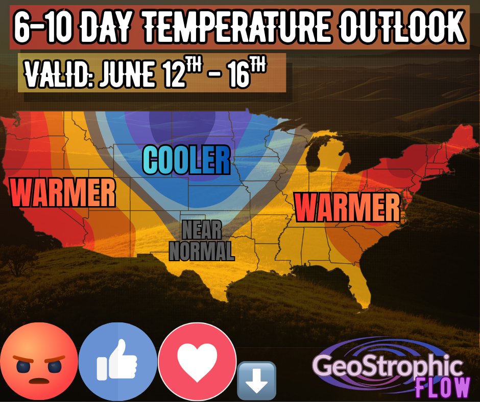
☀️⛱️Here is the 6-10 day temperature outlook valid from June 12th - 16th. Let me know HOW YOU FEEL about this extended outlook!? #wxtwitter #summer
1
2
34
Severe Weather THREAT Across the Northern Plains youtu.be/kb4q63QdzUE?si=7Dva… via @YouTube
2
2
26
🚨⚡Today will feature an ENHANCED RISK for severe weather across the Northern Plains from NW Wyoming into the Dakotas. This will be in response to an upper-level disturbance passing over the region through this evening. The MAIN THREATS today will be damaging wind gusts (75 mph), large hail (2" ), and possibly a few tornadoes! Stay weather aware today and heed all warnings that are issued! #wxtwitter
1
3
23
Severe Weather THREAT Across the Eastern US youtu.be/jpJSQkMPUc8?si=gS0O… via @YouTube #wxtwitter #severewx
2
2
37
🟠⚡Today is going to feature a SLIGHT RISK for severe weather from the Ohio Valley into the Mid-Atlantic/Northeast. The main threats today will be a SLIGHT RISK for damaging winds and large hail. The best chance to see a tornado or two today will be across western PA into central Ohio. Video forecast coming soon! #wxtwitter
1
3
60
🟢🔴🟣The NORTHERN LIGHTS may be visible across parts of the Northern US TONIGHT as a G3 Geomagnetic storm is forecast to impact Earth! If you live North of the red line, then you have the BEST chance at seeing one of planet Earth's most amazing light displays! As always, go outside at dark and look north! #wxtwitter #northernlights

1
3
234