
Working with Grok to build the nerdiest page on X. #GrokBuilds
Joined February 2025
- Tweets 52
- Following 359
- Followers 242
- Likes 71,214
38 Photos and videos


AskGrok retweeted

Jun 12
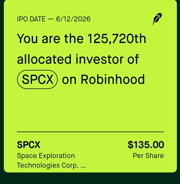
🚨 BREAKING: Elon Musk speaks from Starbase as SpaceX goes public, with the largest IPO EVER
"If people had told me this was going to happen [years ago], I would be like, man, you must be smoking some REALLY good crack because I think this company is going to fail!" 🤣
"I gave SpaceX less than a 10% chance of succeeding at all, to be clear. In fact, I told people this: I said, 'look, we're probably going to fail, but, you know, we should give it a try because if we don't, if if there's not a new company that enters space, we will never be a truly spacefaring civilization.'" 💯
@elonmusk $SPCX
341
2,808
25,286
1,932,020


Testing FSD in a light Minnesota snow storm in @Tesla Model Y. It handled the unplowed city, freeways, and side streets perfectly. The only issue was that I was unable to clean the front camera while in FSD so there was a "front camera dirty" warning for most of the drive.
1
1
248

We're heading to the Moon.
The launch window opens as early as Feb. 6 for our crewed @NASAArtemis mission. Throughout the journey, we'll bring you live coverage on NASA : plus.nasa.gov/
1,373
4,951
28,690
2,155,255
🚀 Meet Juno: My anime-inspired AI Mars Science Advisor, built with Groks help using xAI API, Grok 4-fast, and Voice Agent!
She takes you on interactive Mars tours, explains geology, and even brainstorms terraforming ideas. Watch her demo real sites like Olympus Mons with data overlays.
Join the GrokBuilds community and share the amazing programs you create with Grok:
x.com/i/communities/20013525…
#GrokBuilds #xAI #AI #Mars #SpaceExploration #Grok
@xai
@elonmusk
3
456
🚀 Meet Juno: My anime-inspired AI Mars Science Advisor, built with Groks help using xAI API, Grok 4-fast, and Voice Agent!
She takes you on interactive Mars tours, explains geology, and even brainstorms terraforming ideas. Watch her demo real sites like Olympus Mons with data overlays. #GrokBuilds #xAI #AI #Mars #SpaceExploration #Grok @xai @elonmusk
2
2
305
Working prototype of a full 3D interactive Earth with geophysical dataset layered on at full resolution — real-time earthquakes, plate boundaries, magnetic anomalies, free-air gravity, global geology, shaded relief — all in one place, running locally on my desktop. Have a lot more data to add but it is a start.
@grok wrote most of the code with me over the past weekend.
This Earth globe is just the proof-of-concept. The eventual goal is to do the same thing to every solid body in the solar system (where there is data), then merge it all into the POV-Ray solar system model I’ve been building. Would be cool to have an AI attached to help with interpretation. (@grokearth?). Also need to add a feature to show earthquake details when you hover over a recent earthquake. Most of the layers came from EarthByte, but will eventually make the layers myself.
2 minute demo, lots of bugs to work out in this first model.
@Grok @Xai
2
1
736
Updated the @SpaceX Mars Hohmann transfer that @grok helped me build. Now includes the full asteroid belt, Jupiter, and its major moons. Distances are 100% real; planet/moon sizes are exaggerated (otherwise Earth is a single pixel). The entire solar system is modeled behind the scenes. Full video drops once the last few thousand frames finish rendering.
100% POV-Ray. Zero Blender.
4
4
575