
I'm a climate data and natural hazards scientist living among the most resilient people on Earth!
Joined October 2013
- Tweets 1,588
- Following 294
- Followers 652
- Likes 1,142
314 Photos and videos


28 Oct 2025
Watch LIVE coverage of #HurricaneMelissa’s landfall in #Jamaica! LIVE cam shows flooding at Flat Bridge on Rio Cobre River. Link: m.youtube.com/watch?v=s6c0Bf… #hurricane #flood #Melissa
1
6
817
28 Oct 2025
Check out this LIVESTREAM of #HurricaneMelissa striking #Jamaica! Link: m.youtube.com/watch?v=SibtK_… #hurricane #melissa 🇯🇲 Hoping for minimal impacts!
2
952
27 Oct 2025
Check out LIVE cams from #Jamaica as cat-5 #HurricaneMelissa bears down on the Island! 🇯🇲 Hoping for minimal impacts for our Jamaican friends! Link: m.youtube.com/watch?v=SibtK_… #hurricane #melissa
1
365
20 Aug 2021
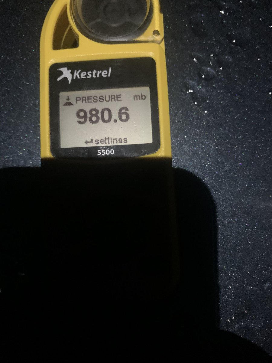
I recorded a minimum pressure of 980.4MB at 512AM CDT in #Tulum, Mexico in #HurricaneGrace. I took this pic at 511AM, when pressure was 980.6. The NHC advisory estimated a pressure of 986mb from Hurricane Hunter plane.
8
19 Aug 2021
Wind picking up in #Tulum, Mexico from #HurricaneGrace. We’re expecting the eye to make landfall near here after a few more hours...
3
3
19
3 Nov 2020
Expecting #HurricaneEta to push a 14-17 foot #stormsurge in #Nicaragua. It would be the largest surge in that country since Hurricane Felix in 2007, according to the international surge database #USurge (u-surge.net)
Hal Needham retweeted

4 Aug 2020
New Video: Here's a look at the storm surge (and surge of sand) on Oak Island, North Carolina earlier with Hurricane #Isaias. Highest surge so far: Myrtle Beach, SC at 4.2' #SCwx #NCwx @NWSWilmingtonNC
42
82
Hal Needham retweeted

2 Aug 2020
The Hazard Area Likeliness (HAL) Map now shows that tropical storm force winds are LIKELY for #PalmBeach and PROBABLE for other areas from the #SpaceCoast to #FortLauderdale in #TropicalStormIsaias #Isaias #HurricaneIsaias
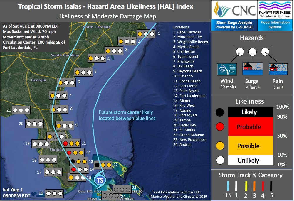
2
1
Hal Needham retweeted
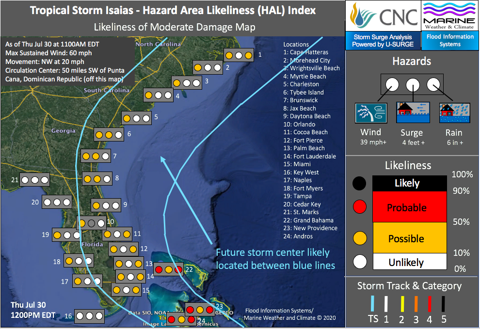
31 Jul 2020
#HurricaneIsaias forecast track has shifted slightly to the west, increasing wind risk for some Florida locations. #HAL map now forecasts tropical storm force winds (39mph ) as PROBABLE from #CocoaBeach and #SpaceCoast south to #FortLauderdale #HurricaneSeason2020 #Isaias
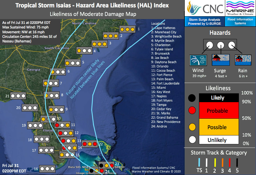
1
2
Hal Needham retweeted
31 Jul 2020
#TropicalStormIsaias takes aim at #Bahamas and then the U.S. It will likely become a #hurricane Friday night. See the latest impact probabilities with our updated Hazard Area Likeliness (HAL) map. #hurricaneseason2020
1
1
Hal Needham retweeted
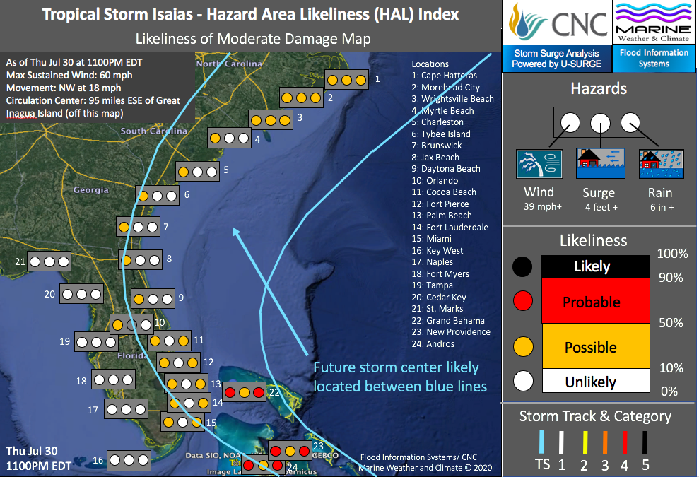
30 Jul 2020
#TropicalStormIsaias is the earliest “I” Storm on record, breaking the previous record by 10 days! I just launched my first Hazard Area Likeliness (HAL) map for this storm, which should impact #Florida this weekend and the eastern seaboard early next week. #Isaias #hurricane
2
3
Hal Needham retweeted
29 Jul 2020
Tracking The Tropics and The Likely Development of Tropical Storm #Isaias #hurricane #hurricaneseason x.com/i/broadcasts/1zqKVeznz…
1
Hal Needham retweeted
28 Jul 2020
Tropical Storm Isaias Will Likely Form East of the Caribbean #Isaias #HurricaneSeason x.com/i/broadcasts/1OwGWLped…
3
2
20 May 2020
Despite Weakening, #TropicalCycloneAmphan Still Capable of Producing High-Impact #StormSurge hurricanehalsblog.wordpress.…
#flood #Amphan #hurricane #Bangladesh #India #CycloneAmphan #AmphanCyclone
2
4
20 May 2020
#stormsurge pushing into coastal areas from tropical cyclone #Amphan
20 May 2020

Super cyclone #Amphan hits #Odisha.
#WeatherUpdate #CycloneAmphan #AmphanCyclone #SuperCycloneAmphan
2
1
18 Apr 2020
The Storm Prediction Center has upgraded the severe weather threat tomorrow (Sunday) along the northern Gulf Coast. They are now forecasting a moderate chance of #severeweather, including #wind damage, large #hail and dangerous #tornadoes.
1
1
Hal Needham retweeted

1 Jan 2020
Dampak kerusakan lingkungan di hulu......lebak gedong dan Cipanas terkena dampak meluapnya sungai Ciberang. #banjir
127
2,311
3,012
5 Sep 2019
Time lapse from #NorthMyrtleBeach as #HurricaneDorian approaches. This is at low tide. Water should breach dunes around high tide early this afternoon. #Dorian #SouthCarolina
1