
Dopaminergic Precision
Joined September 2020
- Tweets 20,871
- Following 296
- Followers 2,188
- Likes 113,172
3,060 Photos and videos


WHEN THE CAT SHITS ON YOUR RUG AT 5 A.M. EASTERN STANDARD TIME 🤎🤎🤎
1
6
101
Video of a fatal car crash on instagram reels and the top comment is the chinese version of InstaCart saying "母狗阴道 👀😂"
4
187
The worst driver you'll meet in your whole life is a 60 year old woman
5
132
If you wore a fake Supreme hoodie in 2017 they raped you to death in public
6
123
Famed internet personality "HymenReaper" Sits down with Psychoanalyst and is admitted to mental health facility within three minutes
8
135
Binding of isaac players be like: I downloaded a mod that gives the necrotic aborted fetus boss Cat Ears
7
111
I did some Tibetan hymnal chants to try and make my moms period cramps worse and she destroyed the whole house bro
10
166
They got it wrong as fuck
May 26

The first map of Korea, created during the Joseon dynasty in 1402.
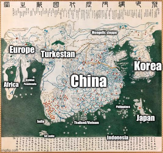
ALT The Kangnido map is Korea’s earliest world map, showing the known Old World from Europe to Japan. It reflects the Joseon dynasty’s ambition to integrate global knowledge, drawing from Chinese, Persian, and Arabic sources. Notably, it features an oversized Korea, highlighting administrative regions, and includes distant areas like Europe and Africa, despite limited direct contact. The map’s inaccuracies reveal early challenges in global mapping, and its survival in Japanese copies highlights Korea’s brief period of international engagement.
14
1,023
1 Billion years of Human History and you exist at the same time as Eating Pussy with Hair
8
263
Mommy will you cut my steak up for me when we go out to eat at Texas Roadhouse
9
143