
Ontario's independent and community-driven weather organization. Providing context to severe weather since 2013. Download our app: InstantWeather.ca/app
Joined April 2013
- Tweets 46,292
- Following 916
- Followers 73,933
- Likes 1,994
9,439 Photos and videos


Pinned Tweet

🚨 OUR BRAND NEW INSTANTWEATHER APP IS READY! 🥳🌪️
Our brand new Instant Weather app has been completely rebuilt from the ground up and it’s FINALLY ready!
This is by far the biggest upgrade we’ve ever made to the app, featuring:
- A MASSIVE radar upgrade
- Dark mode
- Widgets are FINALLY here! (RIP “widget when?” comments 😞)
- A redesigned modern weather page
- And yes, the original weather page is still available for those who loved the classic app
And the improvements don’t stop there…
We’ve also massively improved every subscription tier!
If you previously had 5 hours of future radar, you now get either 12 HOURS or even 48 HOURS of future radar depending on your plan, plus way more past radar data too.
Even the FREE radar experience is dramatically better than before 👀
A HUGE thank you to everyone who subscribes and supports Instant Weather. Your support is what makes major upgrades like this possible ❤️
This is just the beginning. LET’S GO!!! 🚀

11
10
63
11,123
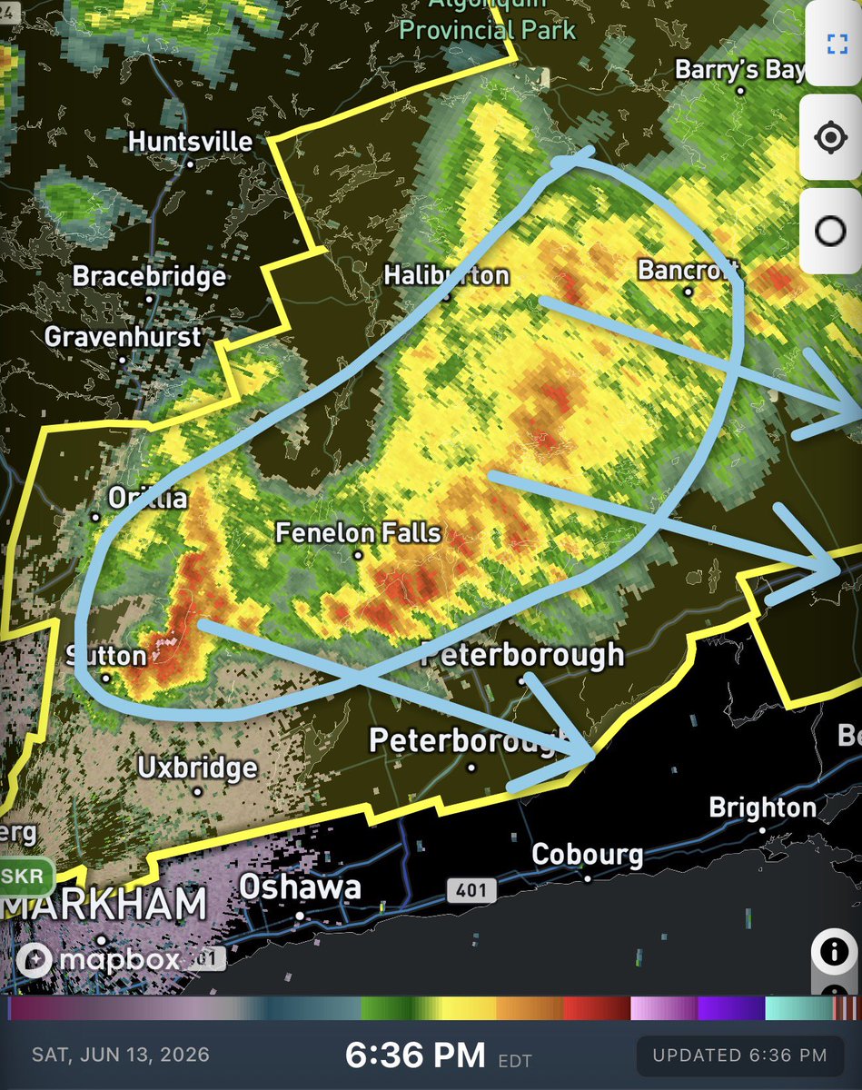
#ONStorm #ONwx 💨 Strong Storms Moving Into Kawartha Lakes and Peterborough Region
Heads up! These storms with a history of producing wind damage in Central Ontario are currently tracking into Kawartha Lakes, Peterborough and Bancroft.
Hazards:
Wind: Damaging (90 - 110 km/h)
Hail: Up to quarter size (up to 2.5 cm)
Rain: Heavy (15 - 50 mm)
Locations in the path: Barry's Bay, Kawartha Lakes, Bancroft
We’re tracking it live: instantweather.ca/live
What are you experiencing?
- Brennen
4
4
21
3,509
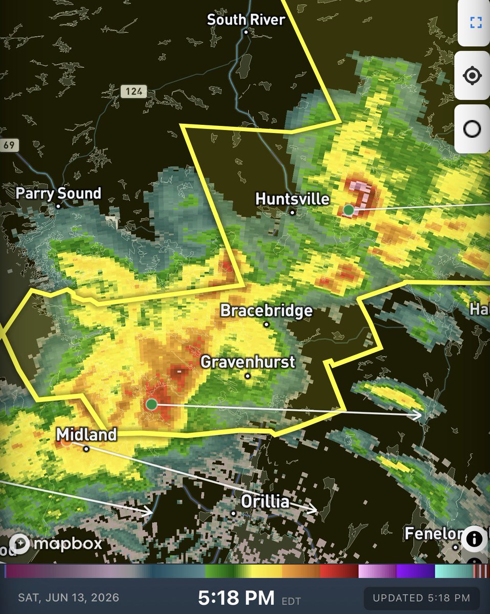
#ONStorm #ONwx 5:25 PM: A cluster of severe warned thunderstorms are currently tracking through the Muskoka area.
We’ve been hearing reports of hail around Huntsville and Lake of Bays.
Strong wind gusts are also possible with this cluster tracking into Simcoe County, Haliburton and Kawartha Lakes.
What are you experiencing?
Join us live: instantweather.ca/live
- Brennen
3
29
4,554
#ONStorm #ONwx 🔴 LIVE | ⚠️ Damaging Wind Gusts & Large Hail Risk for Ontario (Sat, Jun. 13, 2026)
We’re going live this afternoon to track potentially severe storms in parts of Central, Eastern and Northeastern Ontario.
Join us on YouTube starting at 2:30 PM EDT for minute-by-minute storm coverage: youtube.com/live/AxGbFkIm0yc
2
10
29
10,307
#ONStorm #ONwx Please seek shelter in Wallaceburg and Dresden!
VERY strong wind gusts detected on radar.
Join us live: instantweather.ca/live
- Brennen
3
13
3,066
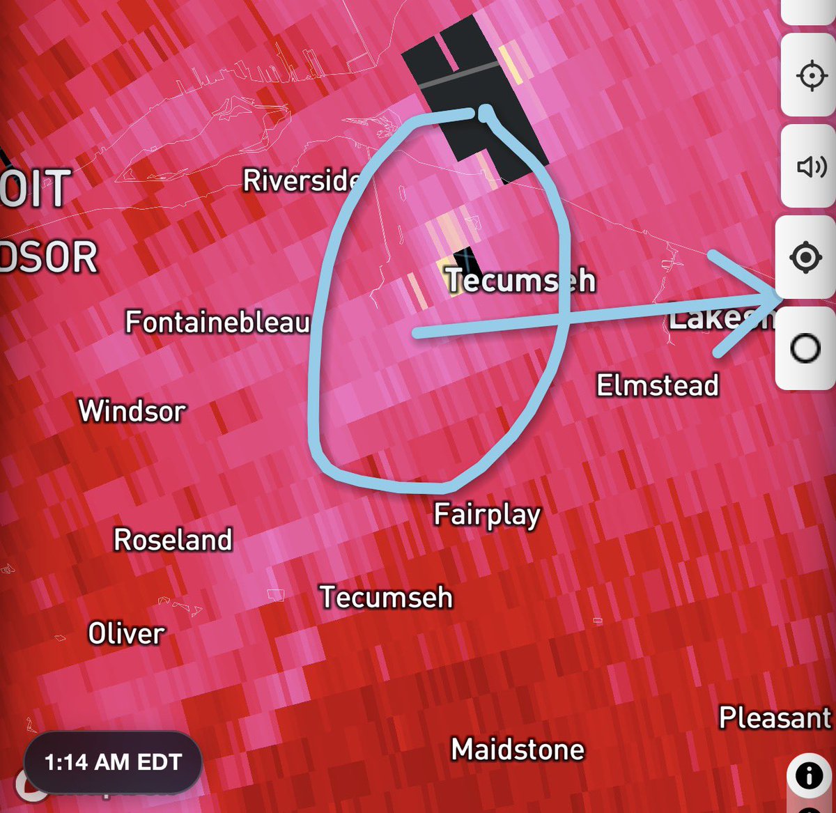
#ONStorm #ONwx 💨 STRONG WINDS IN EAST WINDSOR
Watching this pocket of strong winds on radar near Tecumseh.
Please seek shelter.
Join us live: instantweather.ca/live
- Brennen
3
11
2,721
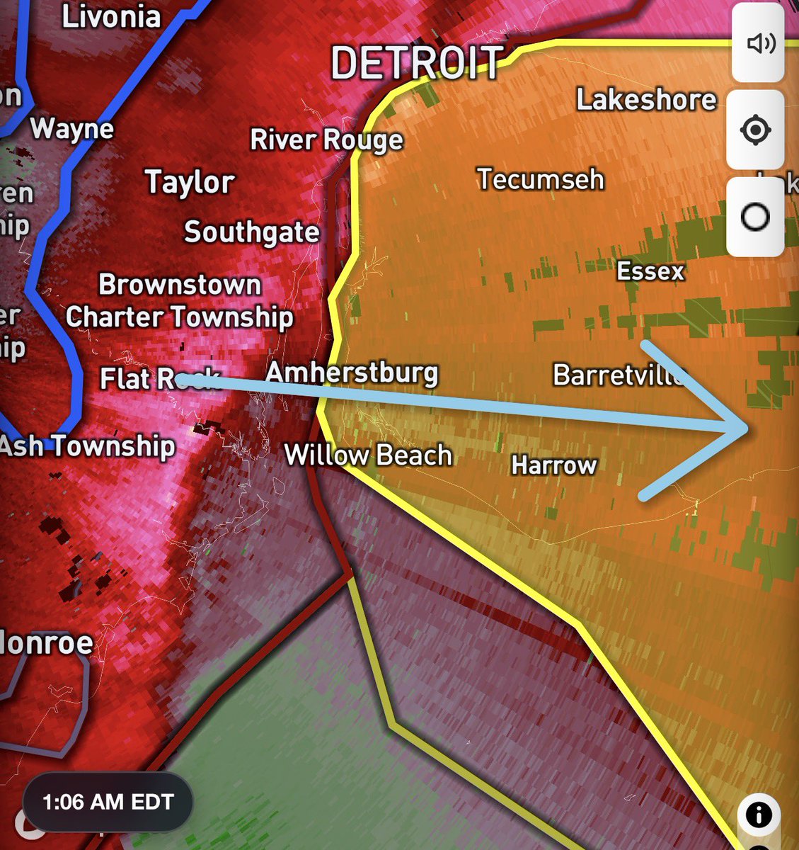
#ONStorm #ONwx ⚠️ Damaging Wind Gusts Tracking Into Essex County
We’re monitoring a pocket of strong wind gusts on radar near Flat Rock, Michigan that as reports of wind damage according to our partners at Michigan Storm Chasers.
This is moving directly into the Amherstburg area.
Please be prepared for damaging wind gusts shortly!
Join us live: instantweather.ca/live
- Brennen
4
11
2,569
#ONStorm #ONwx 🔴 LIVE | 🌪️ Nocturnal Tornado Risk: Ontario Severe Weather Coverage (Fri, Jun. 12, 2026)
Join us LIVE beginning at 12:30 AM as we track a line of severe thunderstorms moving into Southwestern Ontario from Michigan.
We know storms can be stressful, especially at night, but we’ll be here to keep you informed so it’s not as stressful.
Join us on YouTube: youtube.com/live/k8hwAhVmAmQ
1
6
20
7,527
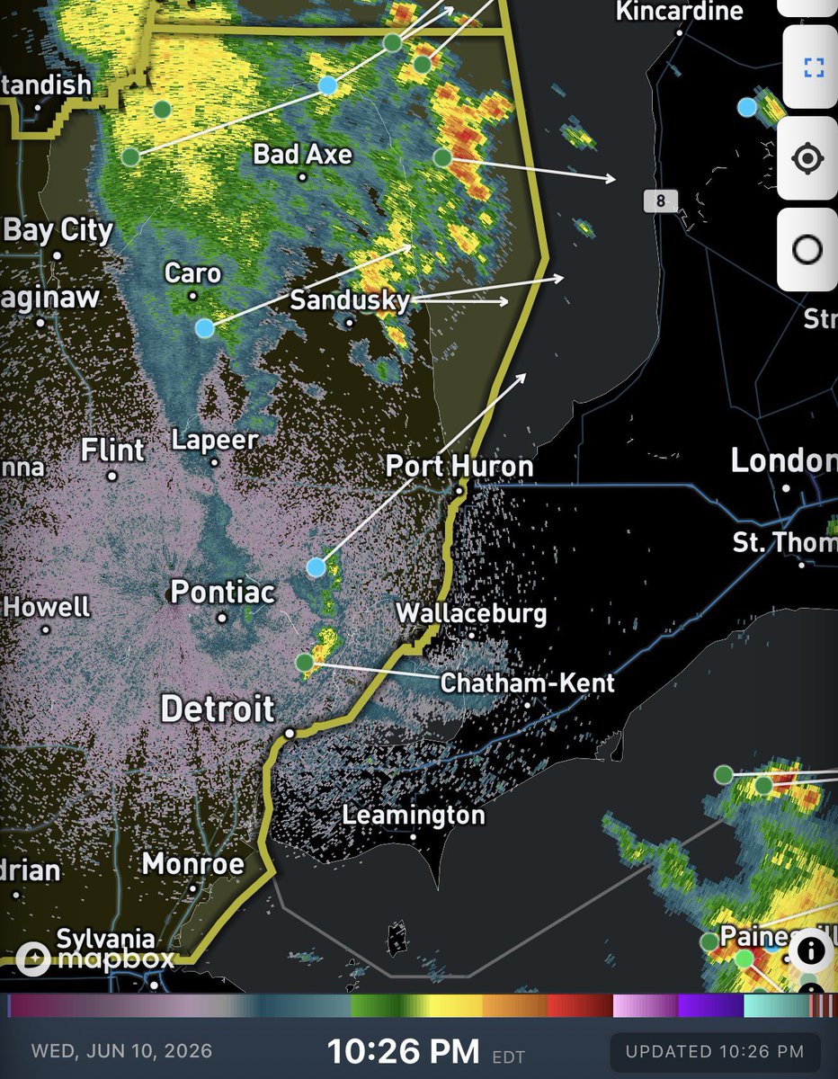
#ONStorm #ONwx 11:25 PM UPDATE:
We continue to track this expansive line of thunderstorms tracking through Michigan and Indiana.
The northern section of the storm that was tracking towards our border does seem to be weakening as it tracks into Detroit. The National Weather Service has dropped most of the severe warnings on that portion of the line.
However, there is another section of the line to the south that is tracking to the northeast and is looking much more stronger. It may eventually become an issue for Essex County.
So far, if we see anything, it will likely be around the 12-1 AM timeframe by the time it reaches our border. We are preparing to do a late night live stream around midnight should these storms maintain their strength as they approach our border.
Stay tuned!
- Brennen
8
21
3,033
#ONStorm #ONwx 🌪️ Nocturnal Tornado Risk for Deep Southwestern Ontario Tonight
As we mentioned earlier today, we’ve been closely monitoring a developing severe weather setup that is expected to move into Southwestern Ontario overnight.
Based on what we’ve seen across the U.S. this evening, there is certainly a risk of severe thunderstorms and even an isolated tornado as this line of storms races toward our region.
Earlier tonight, multiple tornadoes were reported across Wisconsin and Illinois, causing damage in several communities. The same storm complex has continued into Michigan, where our partners at Michigan Storm Chasers are currently reporting a tornado on the ground.
What has our attention is that this line of storms has shown very little sign of weakening so far. We had hoped it would begin to fall apart before reaching the international border, but it continues to maintain its strength as it pushes eastward. We’ll be watching closely over the next few hours to see if any weakening trend develops before it reaches Southwestern Ontario.
Environment Canada has issued a Severe Thunderstorm Watch and notes that a brief tornado cannot be ruled out:
“A line of thunderstorms is moving eastward from lower Michigan. While the main threat will be damaging wind gusts, a brief tornado cannot be ruled out. Although the line is expected to weaken as it approaches the international border, its eventual strength remains uncertain.”
If you’re in Deep Southwestern Ontario, make sure you have a way to receive alerts overnight, as this system is expected to arrive while many people are asleep.
More details soon!
- Brennen
2
11
38
4,892
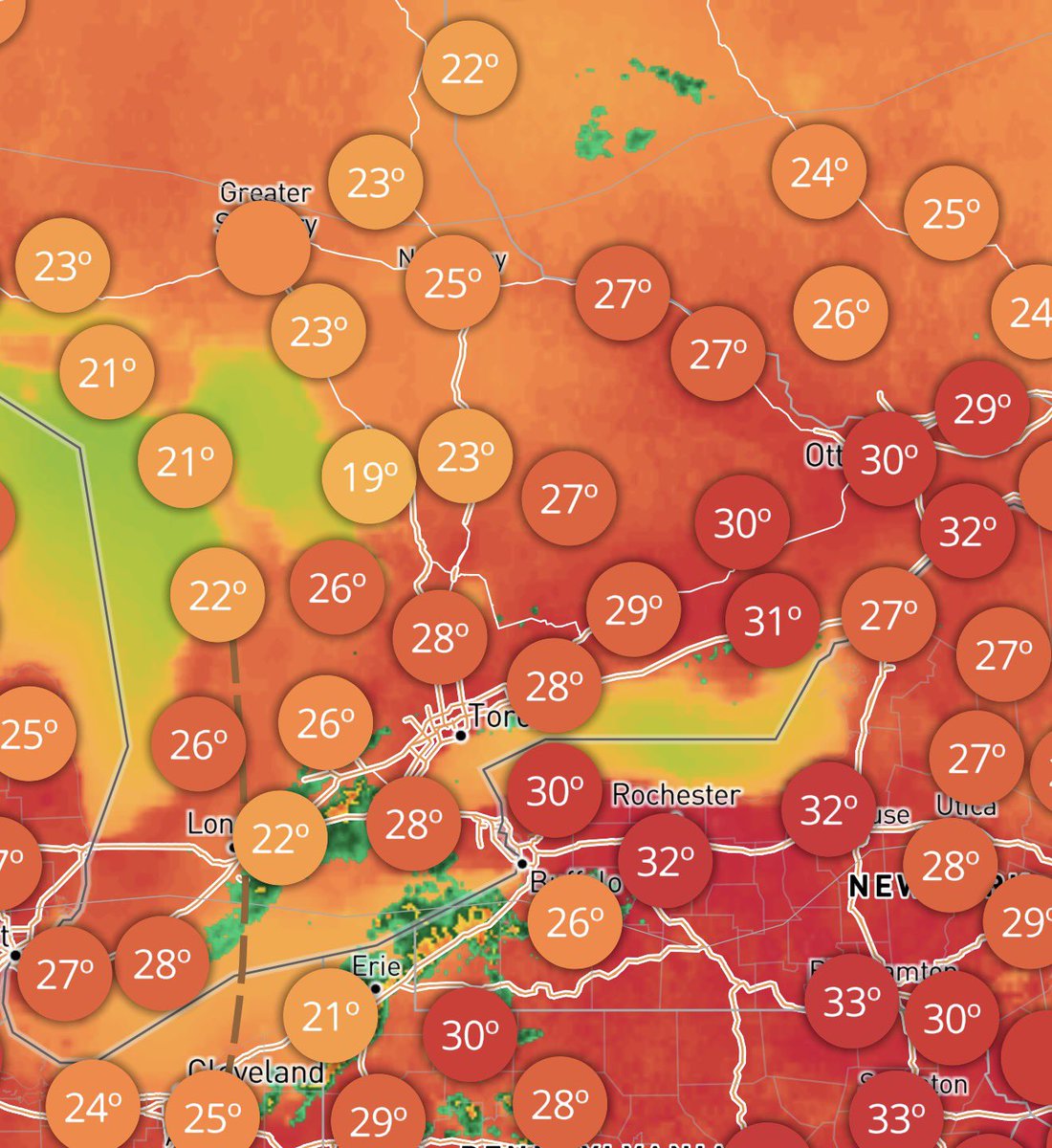
#ONStorm #ONwx It’s a warm one out there today! 🥵
⚠️ Caution: This map uses orange and red colours to indicate hot temperatures. We apologize in advance to anyone who may be startled by the existence of a red map. Please remain calm, take a deep breath, and remember that the sun will rise again tomorrow. 🤗
Many areas across Southern Ontario are seeing temperatures in the high 20s and even low 30s. When you factor in the humidex, it’s feeling more like the mid to upper 30s, making for a very muggy day.
If you’re spending time outdoors, be sure to drink plenty of water, take frequent breaks in the shade or air conditioning, and never leave children or pets unattended in vehicles. Heat-related illnesses can develop quickly, especially during the hottest part of the afternoon.
We are also monitoring the potential for pop-up thunderstorms fueled by this hot and humid air. We’re already seeing some development around Hamilton, where the environment could support the formation of funnel clouds.
While these types of funnel clouds rarely make contact with the ground, in very rare cases they can touch down and become brief landspout tornadoes. We’ll be watching closely for any reports throughout the afternoon.
There is also the potential for a line of thunderstorms to move into Deep Southwestern Ontario later this evening and overnight. There remains some uncertainty regarding how strong the line will be by the time it reaches the border, and it could weaken significantly, similar to what happened with last night’s storms.
We’re keeping a close eye on it!
How are you enjoying the heat today? Hopefully you’re finding a way to stay cool! ☀️
- Brennen
2
8
31
4,536
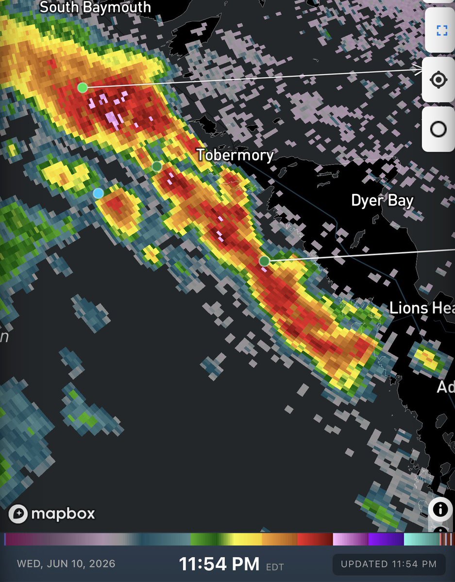
#ONStorm #ONwx 11:50 PM: We’ve seen a bit of strengthening on the storm that just moved inland from Lake Huron and is now tracking through the Seaforth area.
Unfortunately, the Exeter radar, which had recently come back online, stopped providing new data just as this storm moved in. We haven’t received any updates from it in over 30 minutes, which means we don’t have a great look at what’s happening closer to the surface.
Based on data from more distant radar sites, the storm is showing signs of producing small hail and gusty winds as it moves east.
What are you experiencing?
- Brennen
1
3
17
3,136
#ONStorm #ONwx Storm Force Field… ACTIVATE! ⛈️🚫
It looks like the storms may have forgotten their passports, because they’ve completely fizzled out to our south as they approached the Deep Southwestern Ontario border.
We still have a cluster of storms set to cross Lake Huron later this evening, but considering what happened with the storms to our south, it’s questionable whether they’ll be able to maintain their strength. We’ll be keeping a close eye on them!
We could still see some non-severe overnight thunderstorms tonight, especially around the Lake Simcoe region, so don’t be surprised if Mother Nature delivers a rude middle-of-the-night wake-up call. ⚡️
For now, though, it appears the severe weather threat across our region is quickly diminishing. Environment Canada has just ended the earlier issued severe watch.
We’ll be back at it again late tomorrow as another similar setup develops. Like tonight, the threat may end up being weaker locally due to timing, but we’ll be monitoring trends closely.
More details ASAP!
- Brennen
2
19
2,803
#ONStorm #ONwx ⛈️ Thunderstorm Risk Update: Deep Southwestern Ontario
So far, the isolated storms we identified a few hours ago have struggled to establish themselves, with most quickly weakening and dissipating. We’re still monitoring a few stronger storms over Lake Erie, so it remains possible that some activity could work its way north into Essex County. However, with daylight fading, the window for additional development is gradually narrowing.
Our attention is now shifting to a developing line of severe thunderstorm-warned storms over Michigan that is racing toward the international border. Forecast models have done a poor job handling this line, as it has developed much farther east than expected this evening. If the storms can maintain their strength, they could bring a risk of severe weather to portions of Deep Southwestern Ontario over the next few hours.
The National Weather Service has extended its Severe Thunderstorm Watch right up to the Canadian border. Damaging wind gusts up to 95 km/h remain the primary concern.
We’ll be watching closely and will continue to provide updates as these storms approach our region.
What are you experiencing in your area?
- Brennen
8
23
3,033
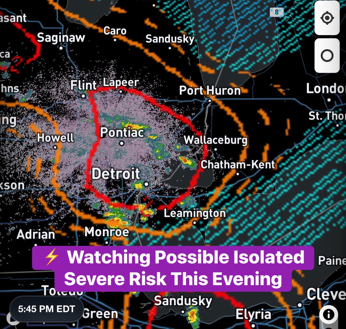
#ONStorm #ONwx ⚡️ Isolated Severe Weather Risk in Deep Southwestern Ontario This Evening
Heads up, Deep Southwestern Ontario! We could be looking at some localized pop-up thunderstorms over the next few hours. In addition, a more substantial area of severe weather is expected to develop across Michigan this evening, with some of that activity potentially crossing the border later tonight.
We’re already seeing a few isolated cells developing around Detroit and into the Windsor-Essex region. So far, these storms appear fairly elevated, meaning they’re struggling to fully establish themselves. Environment Canada has just issued a Severe Thunderstorm Warning for the Windsor area, suggesting further strengthening remains possible.
Storms like these can be particularly challenging to forecast, as weather models often struggle to accurately capture their development. As a result, it’s difficult to know whether these storms will remain elevated or transition into stronger, surface-based thunderstorms.
If some of these cells are able to intensify over the coming hours, the environment would support a slight risk of damaging wind gusts, large hail, localized flooding, and even an isolated tornado.
One of the many ingredients we monitor is something called the Violent Tornado Parameter (VTP), which is overlaid on our map. As you can see, values are reaching 2 across portions of Windsor and Lake St. Clair. This indicates that the atmosphere is capable of supporting rotating storms. The missing piece right now is whether thunderstorms can fully develop and take advantage of those conditions.
At this point, any severe weather threat appears most likely to remain focused on the Windsor, Leamington, Chatham and Sarnia regions.
We’re also monitoring another potential round of storms later tonight, around midnight, associated with a decaying cluster currently expected to move out of Michigan. Most models weaken this cluster as it approaches the border, but if it holds together longer than expected and pushes farther east, some damaging wind gusts could accompany it.
As always, we’ll be watching radar closely throughout the evening and will keep you updated as conditions evolve!
- Brennen
11
20
3,198
#ONStorm #ONwx 🔴 LIVE | 🌪️ SW Ontario Funnel Cloud Risk: Canada's Severe Weather Coverage (Tue, Jun. 9, 2026)
Watch on YouTube: youtube.com/live/lyBZhLva9nw
2
5
23
8,395
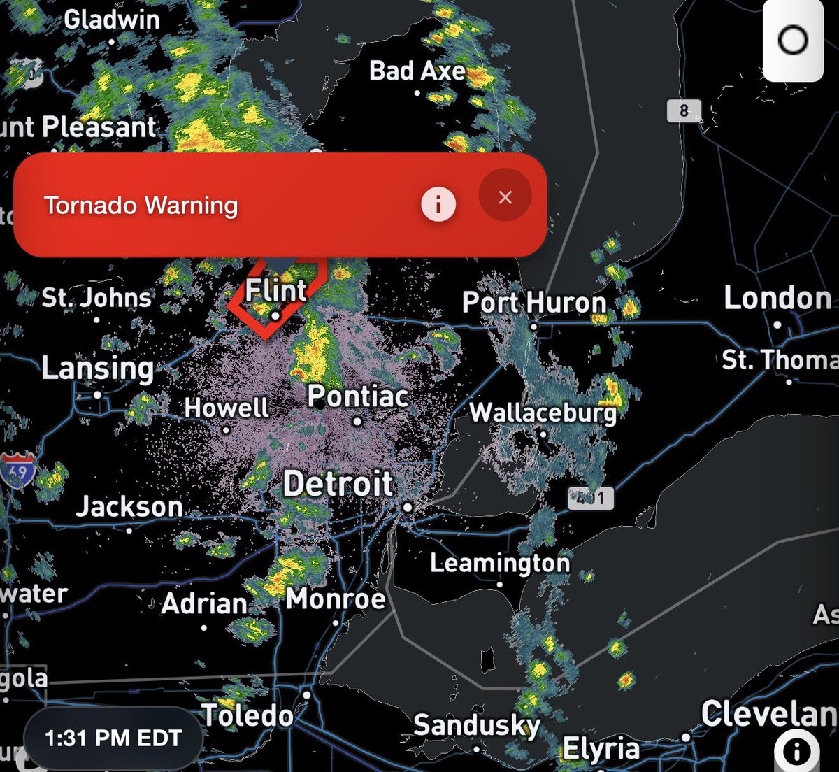
#ONStorm #ONwx 🌪️ Funnel Cloud Potential in Southwestern Ontario Today - 1:30 PM
We’re closely watching the development of pop-up thunderstorms across Michigan and parts of Southwestern Ontario this afternoon.
While widespread severe weather is not expected today, conditions are becoming increasingly favourable for funnel cloud development. In some cases, these funnel clouds can briefly touch down and become landspout tornadoes.
In fact, we may have already seen a possible touchdown in Michigan. Our partners at Michigan Storm Chasers are reporting that a brief tornado may have occurred near Birch Run, northwest of Flint. The National Weather Service currently has a tornado warning in effect for that storm.
Beyond the funnel cloud potential, some areas could also see a much-needed soaking today. These storms are developing in a very moisture-rich environment, which may lead to locally heavy downpours. That would certainly be welcome news for communities that have missed out on significant rainfall over the past few weeks.
We’ll continue monitoring conditions and provide updates if anything develops.
- Brennen
7
35
4,559
#MBStorm #SKStorm 🔴 LIVE | ⚠️ Extreme Tornado, Hail & Wind Risk for Saskatchewan & Manitoba (Sun, Jun. 7, 2026)
Live Coverage Begins At 6 PM EDT!
Join Canada’s Storm Coverage - For Canadians, By Canadians on YouTube: youtube.com/live/7F7c0Inu-kw
2
3
11
8,403
P.S. While this isn’t for Ontario, we wanted to share in case you have family or friends in the risk zone and would like to follow along.
1
11
2,763