With professionalism, respect, pride, and integrity, we protect lives and property; and in partnership with our community provide a safe and secure environment.
Because the snow over Sonora Pass is so deep, @Caltrans9 maintenance crews are using a snow cat to push the snow from above to the road below where the snow blowers can clear it from the highway. This method reduces the snow depth, allowing the snow blowers to push through.
*Inyo County Safety Message*
On behalf of CAL FIRE Incident Management Team 2 currently assigned to the 2023 Inyo County & Mono County winter response, please see the below safety message.
⚠️SAFETY MESSAGE⚠️
Residents and visitors are asked NOT to go near the Owens River or any of the local waterways. The river banks have been severely undercut due to the recent storms, and all waterways are running full and fast. @InyoSheriff#owensvalley#owensriver#inyocounty
UPDATE: The closure on U.S. 395 in Inyo County has EXPANDED. The highway is now closed from Pearsonville to Bishop due to flooding at multiple points of the highway.
We will continue to post updates on this closure to our social media channels as they come in.
ATTN DRIVERS: Due to flooding on the roadway,
@Caltrans9 is closing U.S. 395 from Pearsonville (Inyo/Kern County Line) to Lone Pine.
We will post any updates on this closure to our social media channels as this storm continues to pass through our area.
Rain, wind, snow, flooding...it's everything, everywhere, all at once! Here are all the current road closures in @Caltrans9:
U.S. 395:
From Pearsonville to Bishop.
From north of Bishop to Mammoth Lakes.
From Lee Vining to Bridgeport
From Sonora Junction to Walker.
(1/2)
A Wind Advisory has been issued for portions of Nevada, Arizona and California for Tuesday between Noon and 7 PM PST. Winds could gust to 40 to 50 mph Tuesday afternoon. Blowing debris, strong crosswinds, and lofted dust are all potential impacts.
#cawx#azwx#nvwx
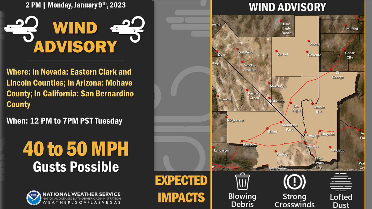
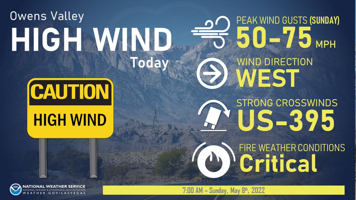
ALT A Wind Advisory has been issued for Eastern Clark and Lincoln Counties in Nevada, Mohave County in Arizona, and San Bernardino County in California for Tuesday between Noon and 7 PM PST (1 PM and 8 PM MST). Winds could gust to 40 to 50 mph Tuesday afternoon. Blowing debris, strong crosswinds, and lofted dust are all potential impacts.
ATTN DRIVERS: The following road closures are still in place:
- U.S. 395 from Gorge Road (11 miles north of Bishop) to Bridgeport.
- State Route 158 S 2.4 miles west of June Lake Junction.
The below video is from earlier along Mammoth Airport (captured on a dash-mounted Go Pro)
Sunny and mild December weather is on tap for our region through Christmas Day. Enjoy it while it lasts as changes are coming next week due to a Pacific System bringing the potential for widespread precipitation Tuesday and Wednesday. #nvwx#cawx#azwx
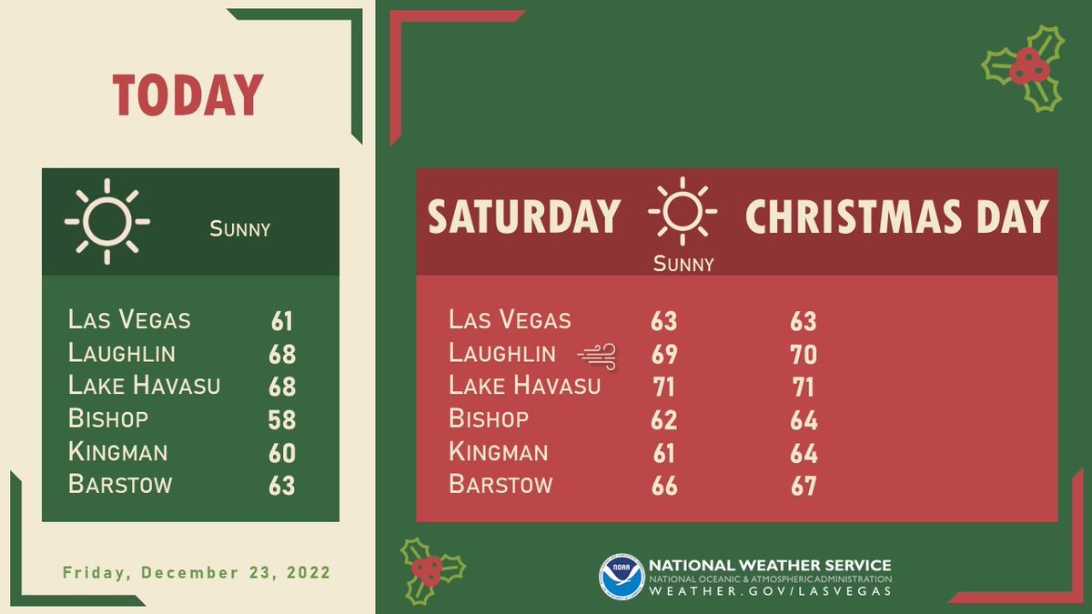
ALT Highs in the lower 60s are expected each day in Las Vegas and around 70 degrees in the Colorado River Valley from Laughlin to Lake Havasu.
NWS Las Vegas Wishes You a Happy Hanukkah!
💙🤍🕯️🕎
Dry conditions expected this holiday week with temps gradually warming to above-average for Christmas Weekend! 🎄🎅
...to the dismay of those hoping for a White Christmas. Maybe next year? 😬
#VegasWx#HanukkahWx#ChristmasWx
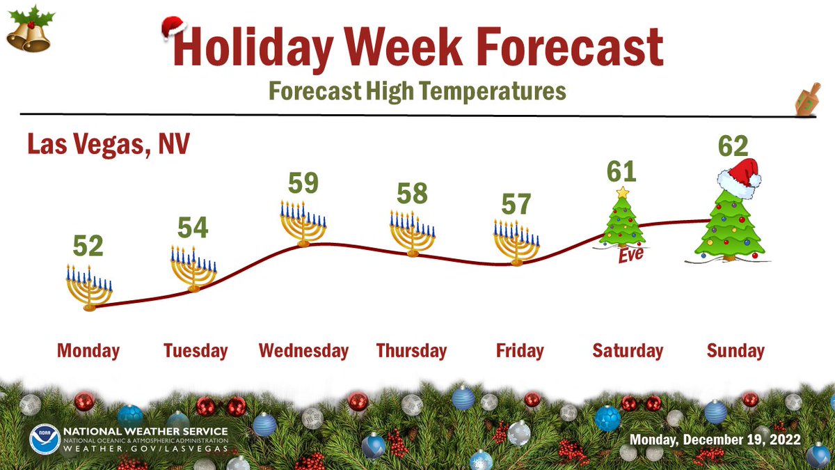
ALT Holiday Week Forecast. Forecast high temperatures for Las Vegas, Nevada. Monday. 52. Tuesday. 54. Wednesday. 59. Thursday. 58. Friday. 57. Saturday. 61. Sunday. 62. Monday through Friday are adorned with Hanukkah menorahs with increasing candles (days 2 through 6). Saturday has a small Christmas Tree with "eve" written underneath. Sunday has a Christmas tree with a Santa hat.
FLASH FLOODING ALERT
Lone Pine Campground is currently flooded and other campgrounds could also be susceptible with the incoming monsoonal storms.
Please avoid the area and use caution before entering canyons if you must.
More details will be forthcoming.
Travel plans today on the US-395 corridor through the Owens Valley? A High Wind Warning is in effect and 50-75 mph crosswinds are possible, so be prepared for travel delays and plan accordingly for the conditions! 🚙 #cawx
#AirportFire Update ⚠️⚠️ All Evacuation Orders and Hwy 168 closure will be lifted as of 6:00pm today. Be mindful of traffic signage and fire personnel in the area. ⚠️ Warm Springs remains closed east from Hwy 395. Incident Update 7:00pm
@InyoSheriff
#AirportFire Update - 3900 acres, 0% containment, no change to evacuations or closures. @InyoSheriff
Photos from initial responding units through the night.
#AberdeenFire remains 25 acres, forward rate of spread stopped. Air tankers released. Extended mop up. Cause under investigation. @Inyo_NF@InyoSheriff@DWP Bishop, Independence, Big Fire Fire
#AberdeenFire 25 acres, moderate rate of spread with potential for 50 in the Poverty Hills Area 395 x Elna Rd. Dispatch Time 12:24pm. Air and ground resources at scene, 1 structure threatened. @Inyo_NF@InyoSheriff@dwp Bishop, Independence, Big Pine Fire