
Joined October 2024
- Tweets 1,603
- Following 2
- Followers 4,156
- Likes 153
407 Photos and videos


Pinned Tweet

Mar 3
Hello Everyone.
In light of the current situation, I have decided to return (at least temporarily) to reporting about Lebanon.
As some of you may know, I mapped out the war in 2024 (Under the name "Cheetah Intel - Project Cheetah").
Since the conflict between Israel and Hezbollah escalated yesterday, I have been working intensely to map out everything amidst the chaos.
Now I am excited to announce Project Cheetah V2!
Currently, I am actively mapping out:
- Air strikes
- Artillery shelling
- Evacuation warnings
- Ground incursions
And more!
I am putting in as much work as I can, but I am also just a human. While I am giving my absolute best at staying transparent and reliable, I can also make mistakes and map data may be inaccurate, false or baseless.
Especially for air strikes and shelling, data may be inaccurate (as it is an ENORMOUS effort to verify every single strike).
Any dates / times mentioned on the map are in local time.
Please note that work is still in progress and some things are still to be added. Everything is based on OSINT (Publicly available information).
And lastly, if you have any suggestions, just let me know! I am happy to adapt the map to what's best for you to view.
View the map here:
google.com/maps/d/viewer?mid…
8
12
82
34,817
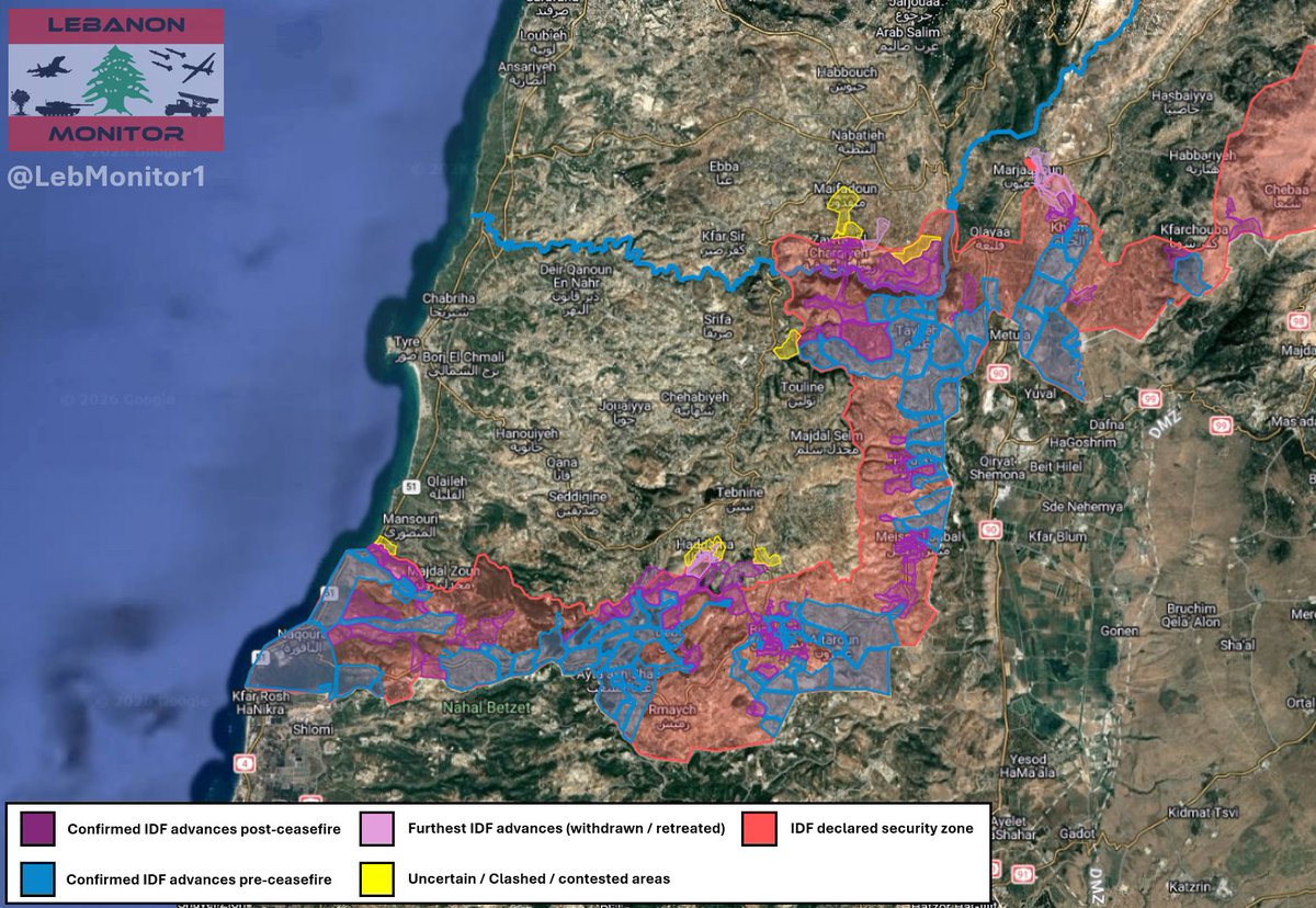
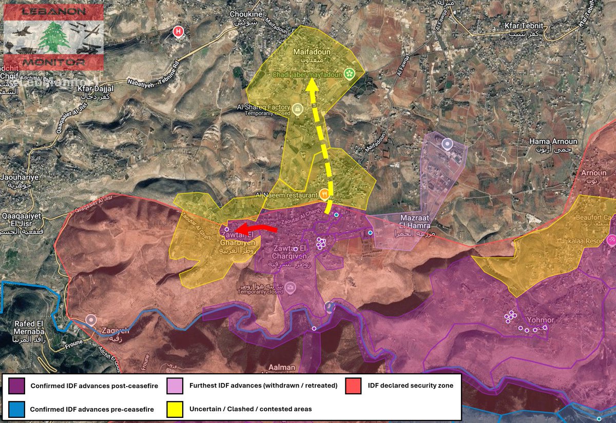
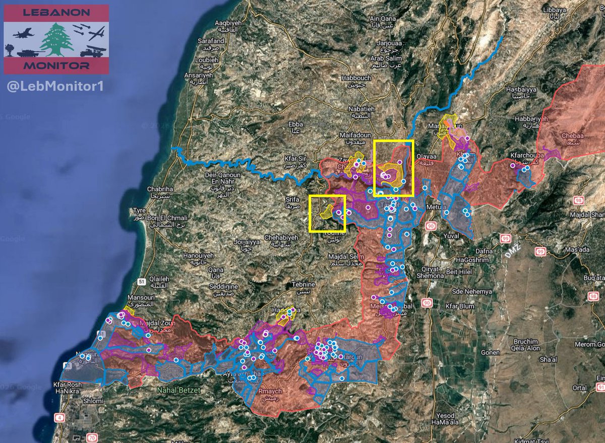
South Lebanon ground situation update - June 10 - June 13, 2026
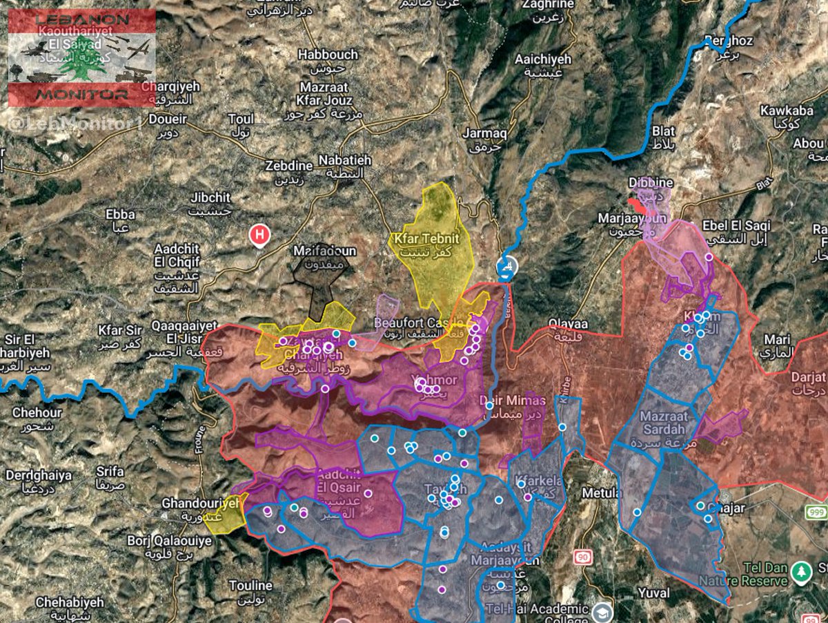
North Litani sector:
- After launching a major ground attack towards Kfar Tebnit / Ali Al-Taher overnight, sentinel 2 satellite imagery from today shows ground activity along the eastern outskirts of Kfar Tebnit, reaching into parts of parts of the eastern neighbourhoods of the town.
- Following reports of an Israeli attempt to advance towards Mayfadoun around June 7, ground activity reaching the southern outskirts of the town is visible on todays satellite imagery.
Central sector:
- Satellite imagery also shows that the IDF infiltrated Kounine, coming from the direction of Bint Jbeil. Ground activity is visible in parts of the southern and western neighbourhoods.
Western sector:
- After the IDF launched a ground attack on Majdal Zoun around 3 days ago, satellite imagery shows ground movements along wadi Hassan towards the eastern outskirts, reaching into the southern part of the town.
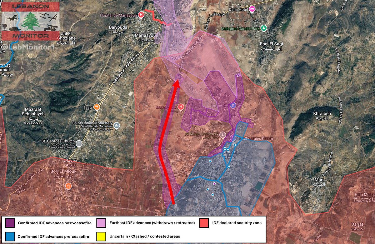
Eastern sector:
- New ground activity visible along a road west of Khiam.

1
5
57
9,894
1: Kfar Tebnit
2: Zawtar Al-Charqiyeh / Mayfadoun outskirts
3: Kounine
4: Majdal Zoun
1
16
1,203
Jun 12
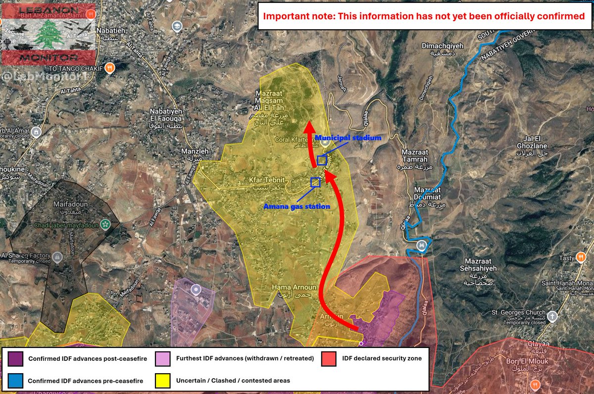
Quick update on what is happening according to unconfirmed (!) reports:
- The IDF reportedly advanced along the eastern direction, reaching the municipal stadium and the Amana gas station.
- From there, they are attempting to advance towards Ali Al-Taher.
- Confrontations continue in the area.
Please take this with a grain of salt as no official sources or major news outlets have reported about it yet.
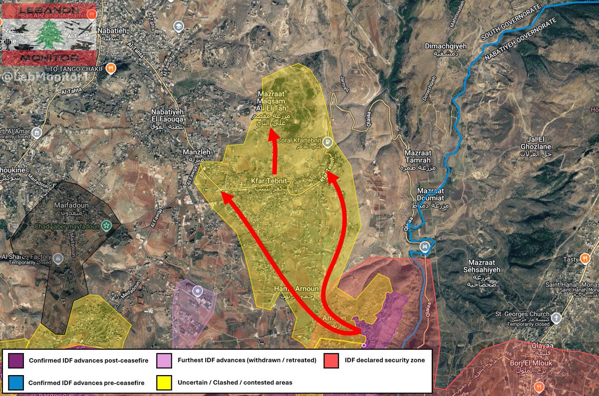
Jun 12

It appears that the IDF has begun a major ground attack towards Kfar Tebnit and Ali Al-Taher.
Israeli forces reportedly started infiltrating towards Kfar Tebnit from the direction of Arnoun, in an attempt to advance towards the Ali Al-Taher area.
Reports say confrontations between Hezbollah and Israeli forces are ongoing.
4
10
88
11,279
Jun 12
It appears that the IDF has begun a major ground attack towards Kfar Tebnit and Ali Al-Taher.
Israeli forces reportedly started infiltrating towards Kfar Tebnit from the direction of Arnoun, in an attempt to advance towards the Ali Al-Taher area.
Reports say confrontations between Hezbollah and Israeli forces are ongoing.
12
133
18,328
Jun 12
After manually reviewing nearly 4,000 buildings one by one, using high resolution satellite imagery from June 9, I have finally completed a detailed damage assessment of Nabatieh.
Approximately 234 buildings appear to be fully destroyed, with a further 183 buildings severely damaged (major sections missing or at apparent risk of collapse). Another 379 buildings sustained moderate damage (e.g from debris impact).
In total, roughly one in five buildings in Nabatieh appears to have sustained notable damage.
This brings the total damages to an estimated $250 million, however please note that this was very broadly calculated and may be inaccurate.
The attached chart provides a more detailed breakdown of the findings. I am also working to migrate the data into the interactive map to make everything easier to explore.
8
33
155
13,714
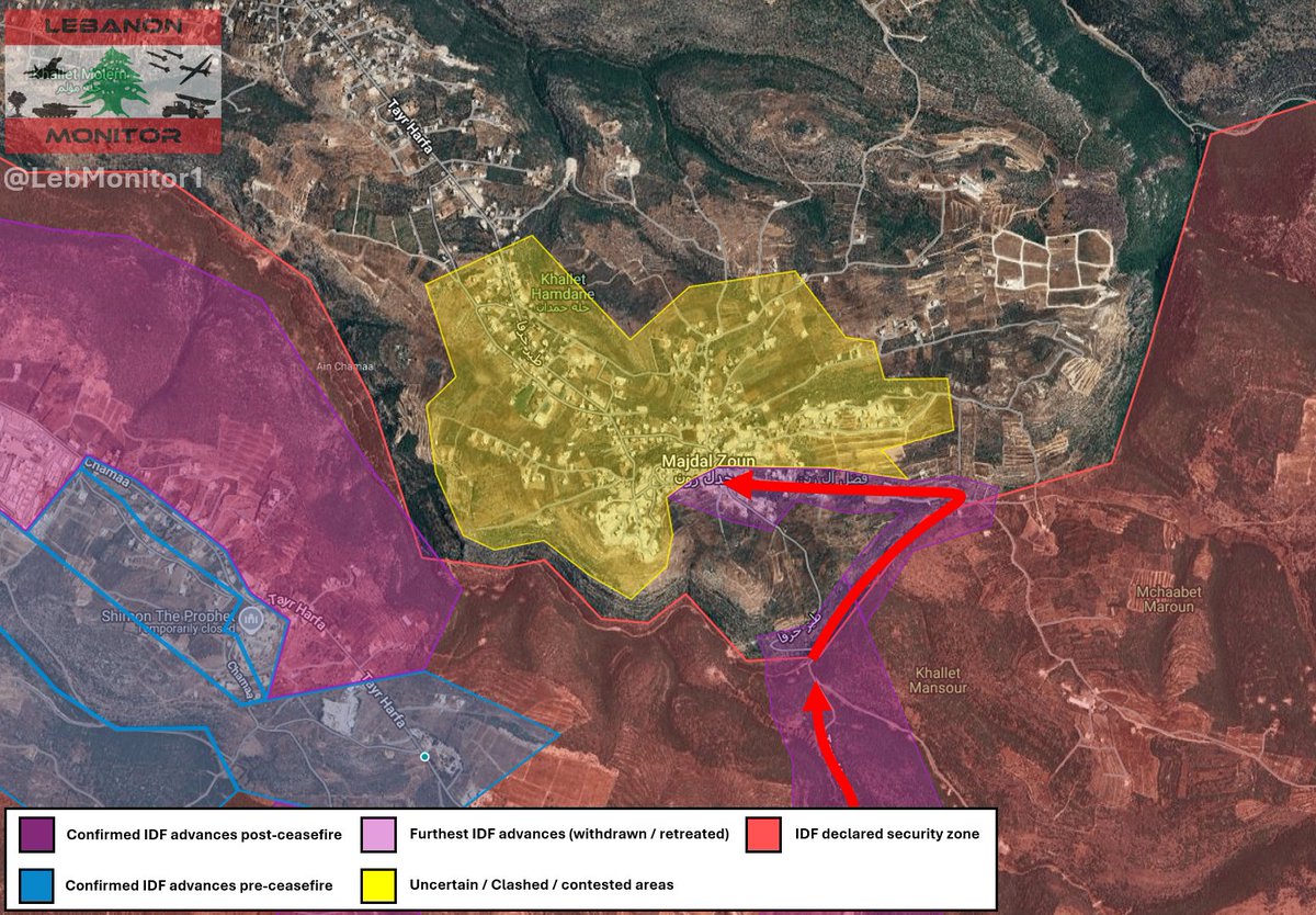
Jun 10
Unconfirmed reports speak of an Israeli ground attack towards Majdal Zoun, likely from the direction of Tayr Harfa via Wadi Hassan. Clashes are reportedly ongoing on the outskirts of the town as the IDF is attempting to advance.
Will update as soon as more information is available.
3
48
4,070
Jun 10
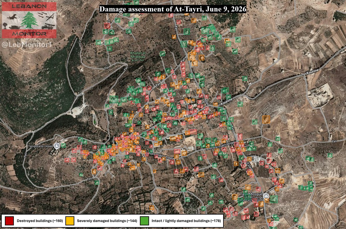
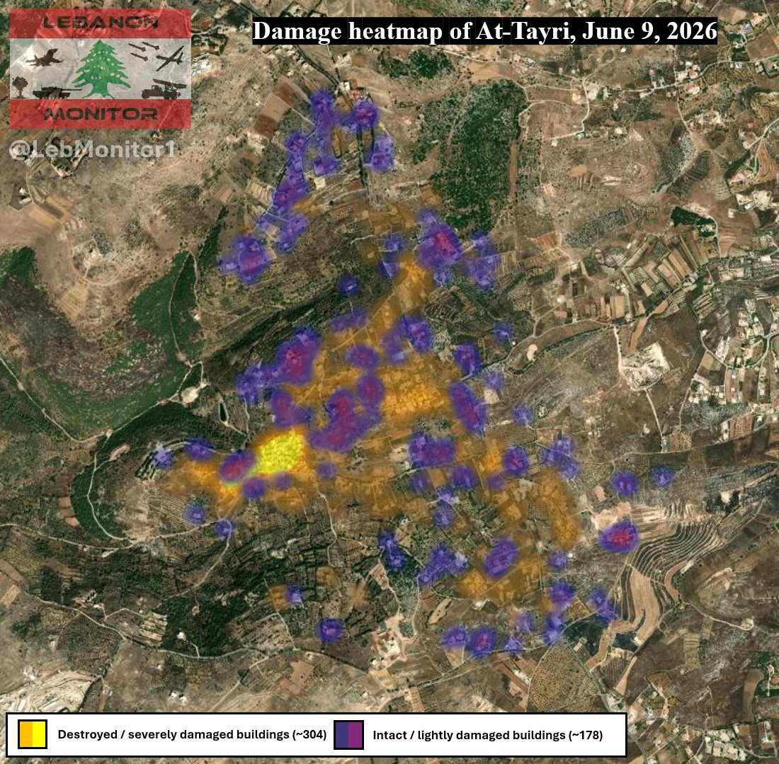
Assessing damage in Southern Lebanon - At-Tayri
I have begun an in-depth damage assessment of several towns in southern Lebanon, starting with At-Tayri.
Using high resolution satellite imagery from yesterday (June 9), I carefully reviewed the town and manually mapped out nearly 500 buildings, recording the current condition of each structure.
The initial findings are as follows:
~160 Buildings were completely destroyed
~144 Buildings sustained severe damage
~178 Buildings remain intact or show only light damage
Overall, around 63% of the town’s buildings were either completely destroyed or severely damaged. Of the total buildings assessed, roughly 33% were fully destroyed, while another 30% sustained severe damage.
I have also mapped this data onto the interactive map, so you can go check out the status of buildings for yourself:
google.com/maps/d/viewer?mid…
3
5
51
4,730
Jun 9
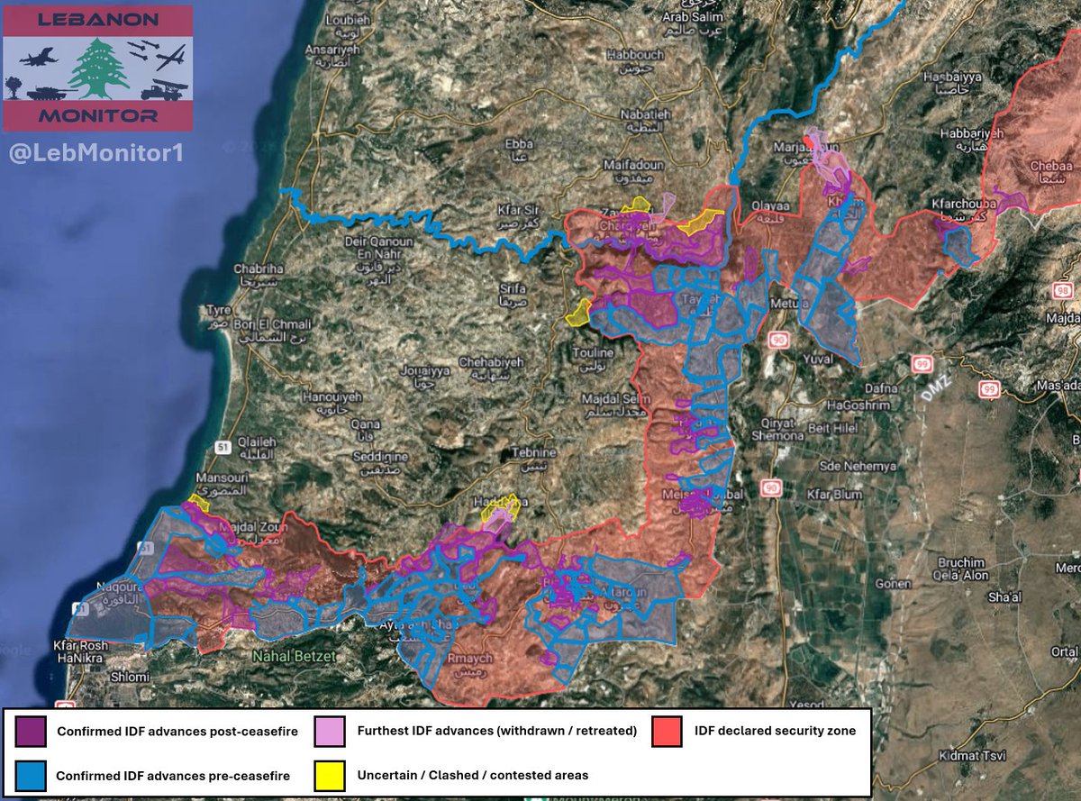
South Lebanon map update - June 9, 2026:
North Litani sector:
- The IDF advanced towards parts of Zawtar Al-Gharbiyeh.
- According to Al-Manar, Israeli forces attempted to advance towards Maifadoun overnight on June 6 to June 7. Hezbollah reportedly repelled the attack.
Central sector:
- The IDF launched a ground attack on Beit Yahoun from the direction of At-Tayri, so far reaching into the western and southern parts of the town.
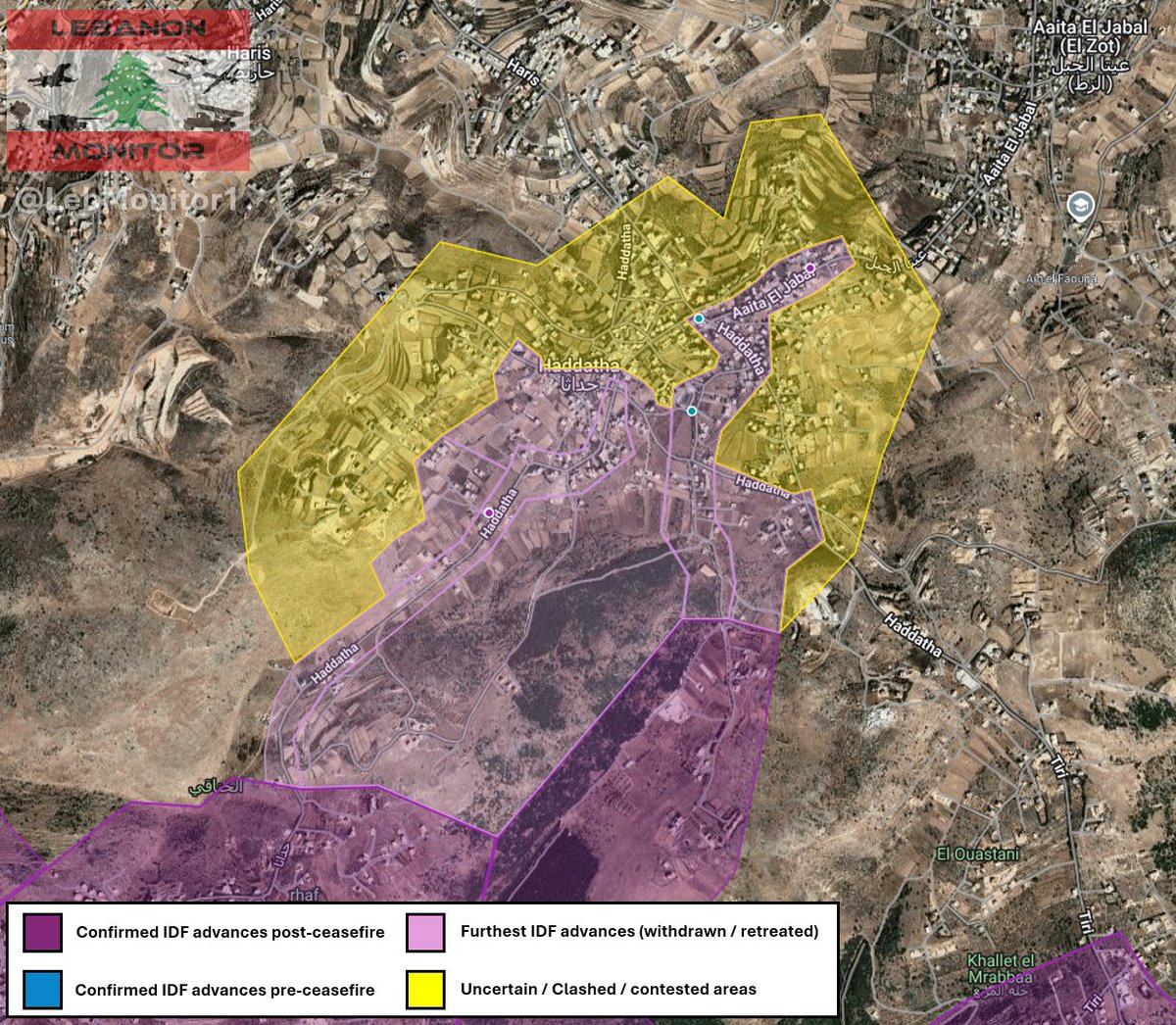
- From the same direction, the IDF also moved towards the eastern outskirts of Haddatha, attempting to further infiltrate into the village. Hezbollah stated that they repelled any new attempts to advance.
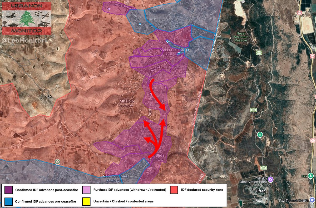
- Israeli forces also advanced in Blida (from the direction of it's southern neighbourhoods) and the southern outskirts of Mays Al-Jabal (from the direction of Mays Al-Jabal).
Western sector:
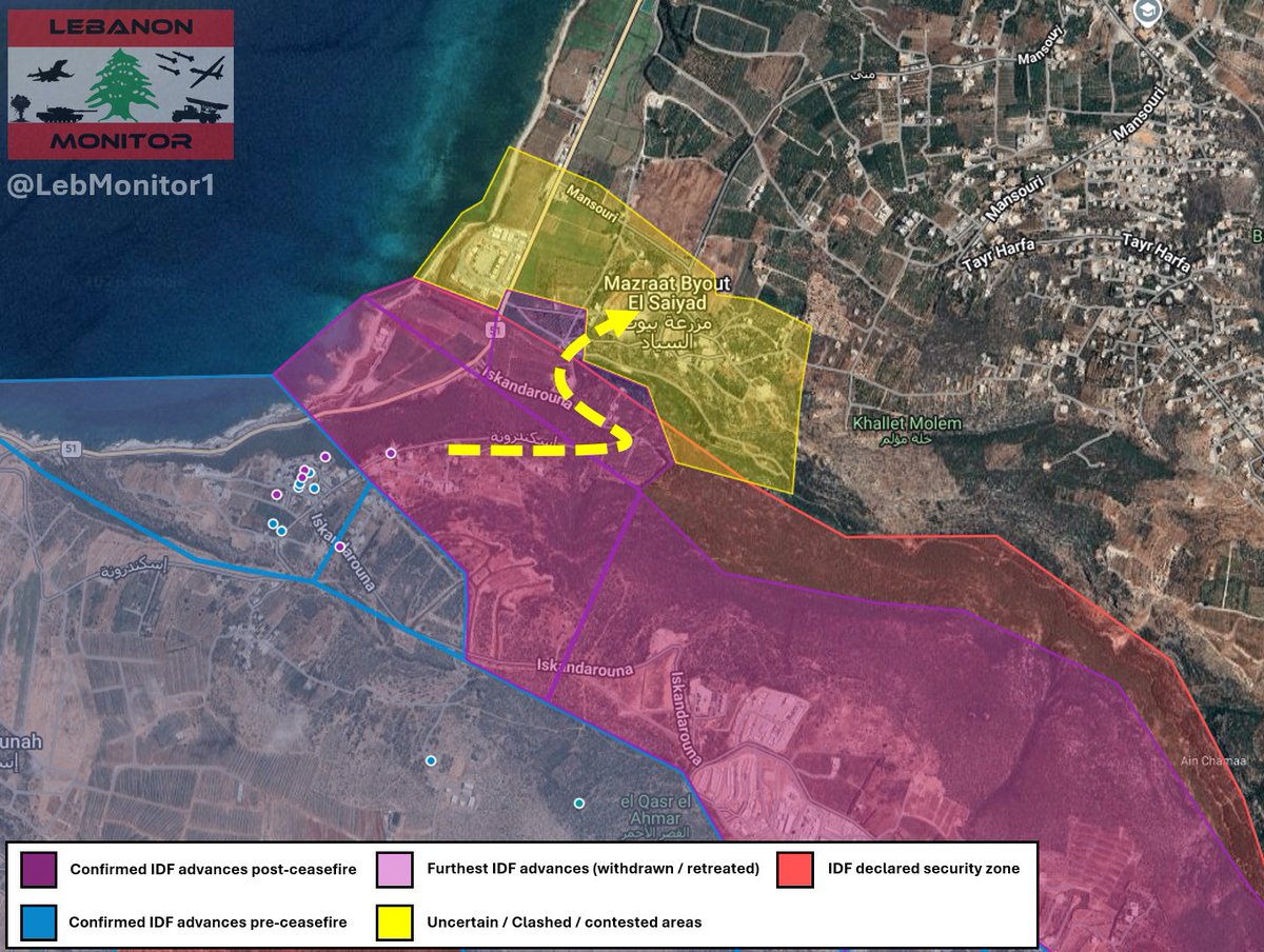
- Following a failed ground attack on Byout Al-Sayyad about one month ago (May 7 to May 9), Israeli forces overnight launched a second ground attack on the town. Hezbollah states that they repelled the attack.
As always, please note that this data is based on public satellite imagery, official statements, and various reports.
Picture of the full map as well as some satellite imagery is in replies.
Map link: google.com/maps/d/viewer?mid…

1
6
51
5,323
Jun 9
1: Full map
2: Beit Yahoun
3: Blida / southern outskirts of Mays Al-Jabal
1
1
17
1,849
Jun 9
A security incident is currently taking place on Israel's northern border.
At least one gunman, believed to be a Hezbollah fighter, reportedly attempted to infiltrate towards Misgav Am / Margaliot / Manara.
The IDF claims to have eliminated one person so far and stated that the incident is still ongoing.
Awaiting further information.
1
3
23
3,284
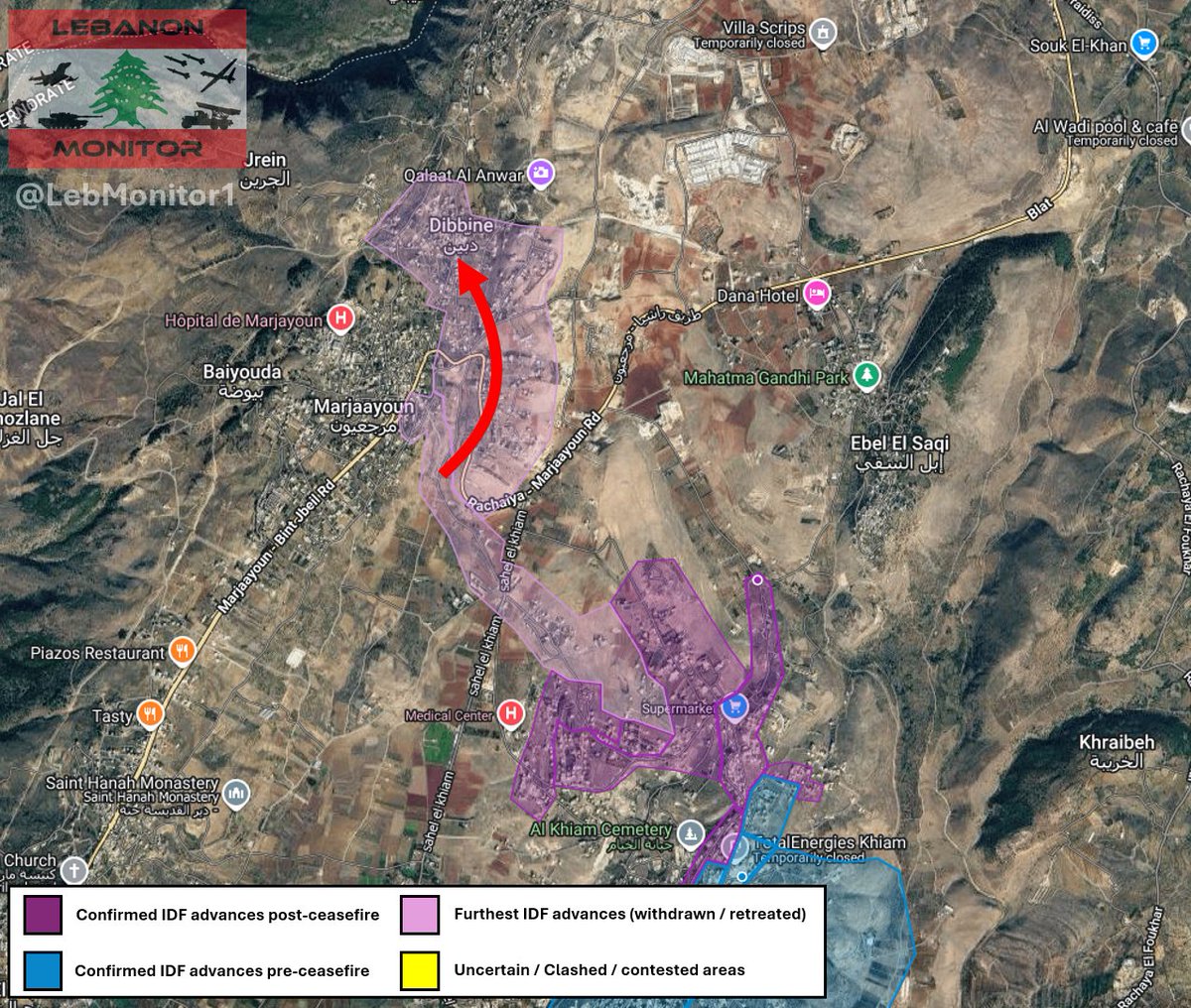
Jun 4
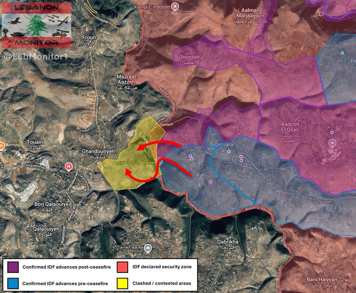
South Lebanon ground update May 30 - June 4, 2026:
Eastern Sector:
- Following an Israeli ground attack towards Debbine on May 28, Sentinel 2 satellite imagery (via the Copernicus dataspace ecosystem) from June 3 shows ground activity reaching into the town, as well as enormous damage all across the area.
- Earlier today, after the IDF withdrew from the town, the Lebanese army entered and begun work to reopen the main roads.
North of Litani:
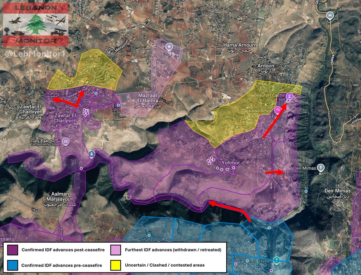
- On sentinel 2 satellite imagery, ground activity is visible across the majority of Zawtar Al-Sharqiyeh.
- Expansion work is visible south of Yohmor at the Litani river area.
- The IDF reached the Beaufort castle area in Yohmor as well as it's eastern outskirts.
Central Sector:
- Following an attempt to advance towards Ghandouriyeh around May 30 (per Hezbollah statements), sentinel 2 satellite imagery shows no signs of ground activity in the area, suggesting that the IDF failed to advance here.
- High resolution satellite imagery of Haddatha from June 3 shows no IDF presence in the area, suggesting that any new attempts to advance have failed so far.
Sentinel 2 imagery in replies
1
5
33
4,975
Jun 4
1: Debbine
2: Zawtar Al-Sharqiyeh
3: Yohmor
4: Ghandouriyeh
7
1,456
May 30
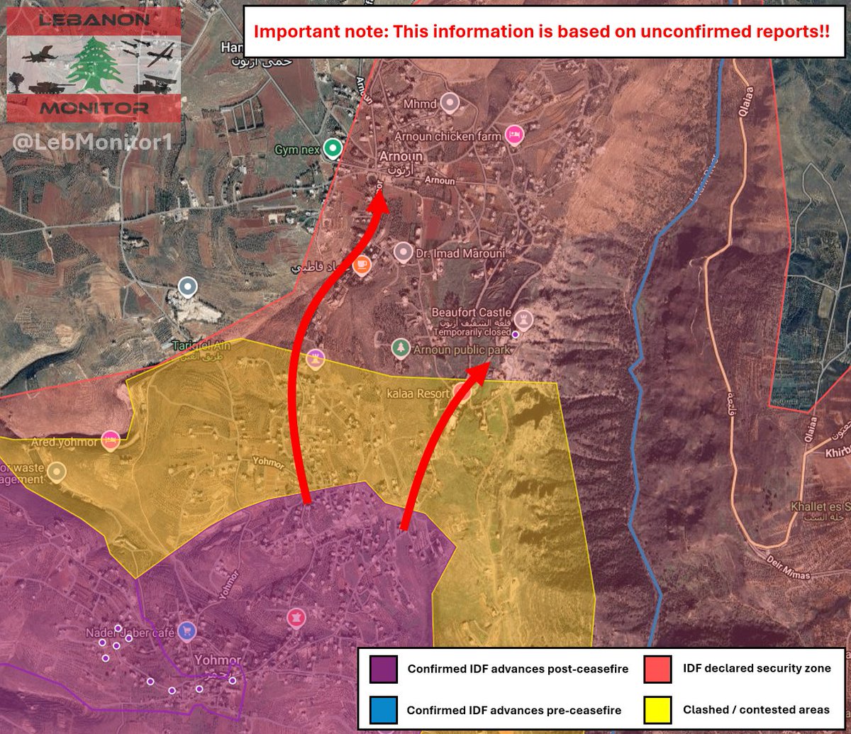
Israeli forces launched a new ground attack in the eastern direction of Ghandouriyeh earlier today, coming from Qantara via Wadi Al-Hujeir.
According to Hezbollah statements, confrontations have so far been limited to the eastern outskirts of the town.
Unconfirmed reports also speak of an Israeli attempt to advance towards the Beaufort castle and Arnoun from the direction of Yohmor, claiming that clashes are taking place in the area. Other reports also state that heavy shelling is targeting the area.
However, as said, these reports have so far not been confirmed by any official or independent source. I will update as soon as more information becomes available.
Additionally, Hezbollah confirmed yesterday the Israeli ground attack on Debbine - Marjayoun, stating that they targeted a tank in the area.
9
11
99
9,175
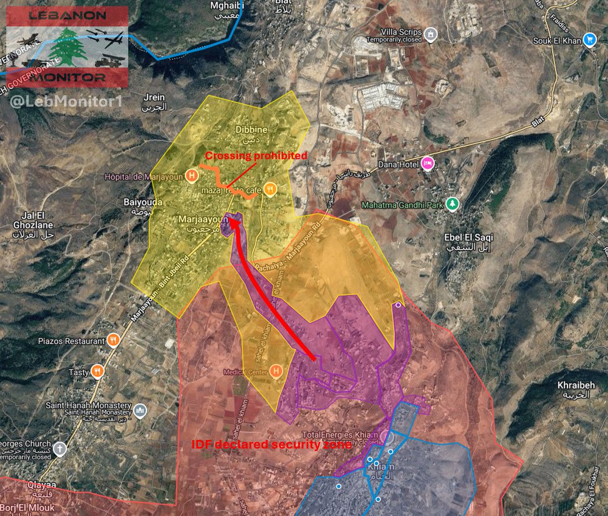
May 28
The IDF reportedly launched a new ground attack towards Marjayoun and Dibbine.
According to current reports, the IDF sent out a warning to residents of Marjayoun, prohibiting them from crossing the red line (marked on the map).
The area has been shelled over 100 times with artillery and air strikes in the past few hours, and Israeli troops have reportedly reached Jdeidet Marjayoun by now.
Heavy machine gun fire is also reported to be heard in the area.
Please note that this data is currently only based on reports, there is no official or independent confirmation for any of the events happening at this time.
I will update as soon as more information is available.
7
12
85
11,279
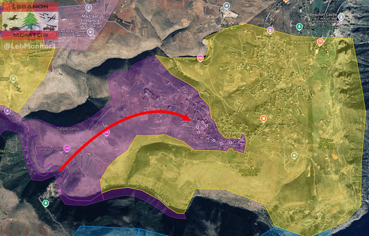
May 28
In addition to the ground attack on Zawtar Al-Charqiyeh, the IDF started infiltrating Yohmor (located east of Zawtar Al-Charqiyeh).
High resolution satellite imagery published on X, dated today morning, shows Israeli tanks and armored vehicles reaching as far as the pond of the town.
2
13
83
7,880
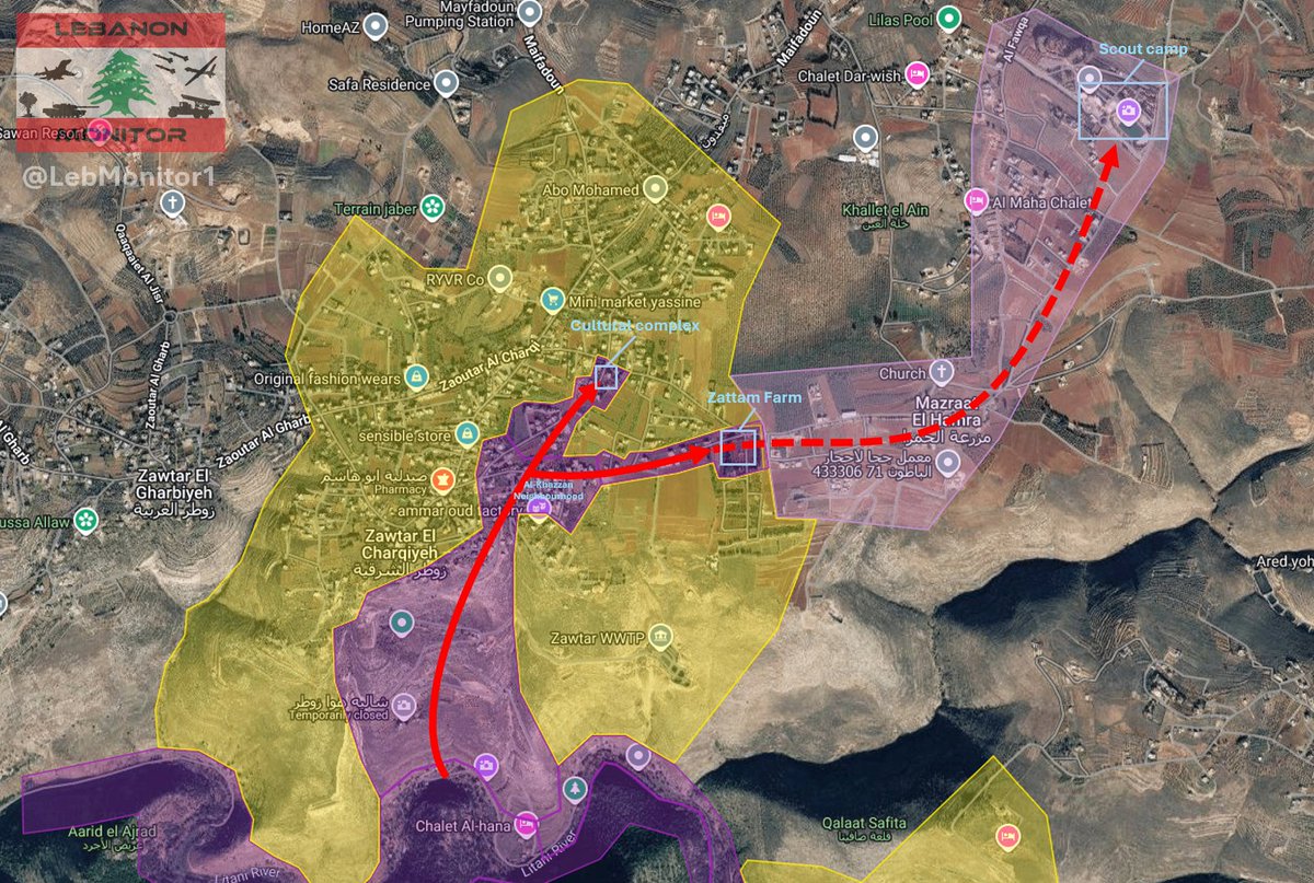
May 27
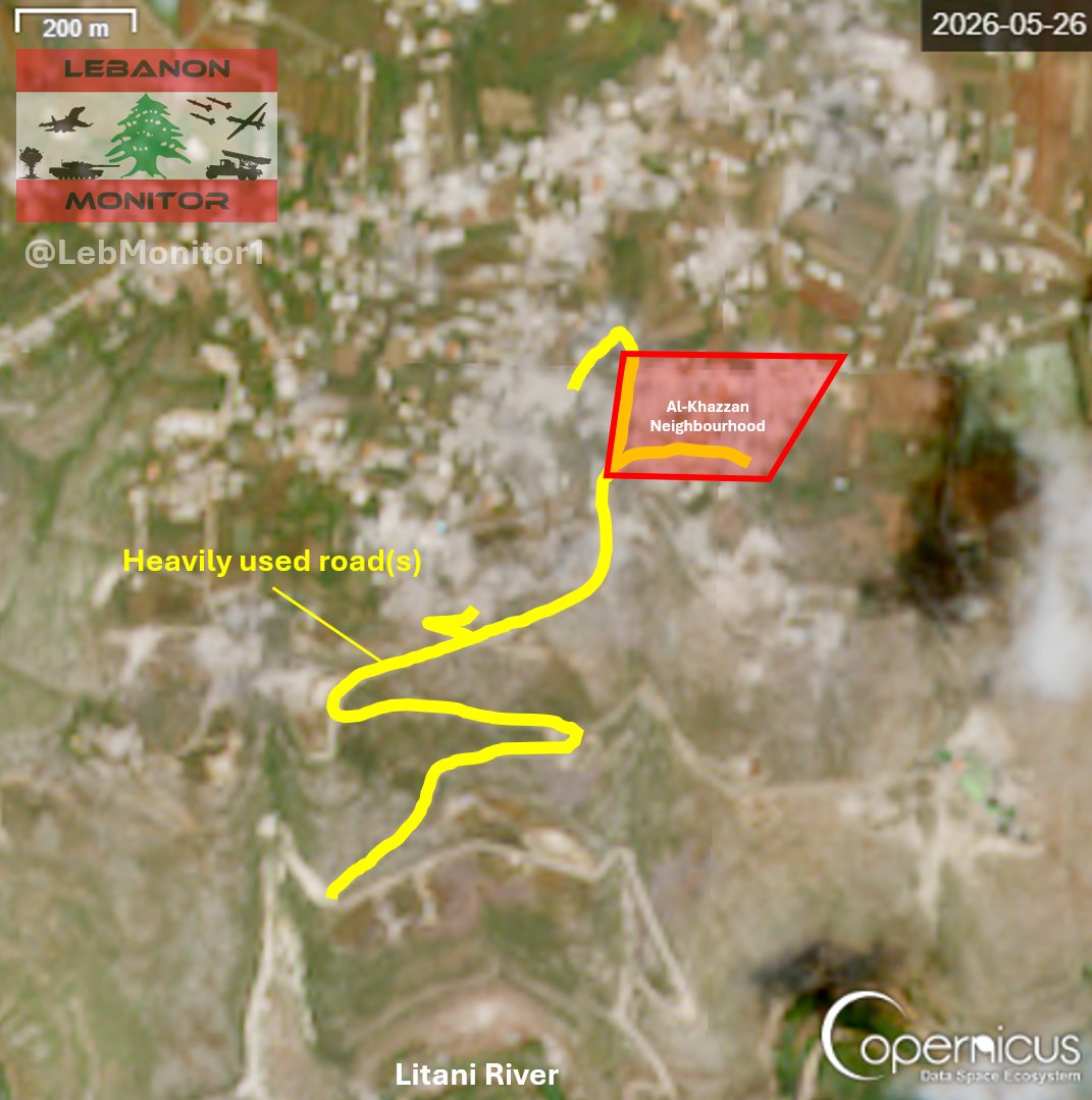
The IDF continues it's ground attack on Zawtar Al-Charqiyeh, here is what we know as of now:
- Israeli forces are trying to push towards the eastern areas of the town, where clashes are taking place, according to reports.
- Hezbollah stated that they repelled an attempt to advance towards the scout camp.
- In addition to other operations, Hezbollah also stated that they targeted Israeli positions at the cultural complex and at the Zattam farm.
- Sentinel 2 satellite imagery from yesterday (May 26) shows heavily used roads (indicating ground activity) reaching into the Al-Khazzan neighbourhood. Lots of damage across the entire area is also visible.
1
10
54
8,501
May 26
After advancing towards the Litani river around 2 weeks ago, the IDF launched a ground attack on Zawtar Al-Charqiyeh today. Hezbollah stated that clashes erupted in the morning and are still ongoing as of noon.
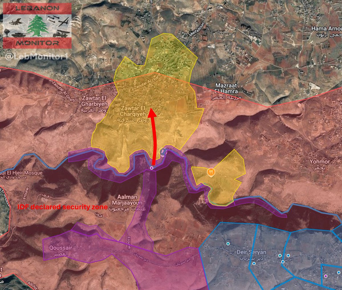
3
20
104
9,818
May 26
Apologies for the edit about Haddatha. After following up, I realised that the statement was talking about the Israeli attack on May 19 - Dawn of May 20, not the attack which occured later on May 20.
1
13
1,851
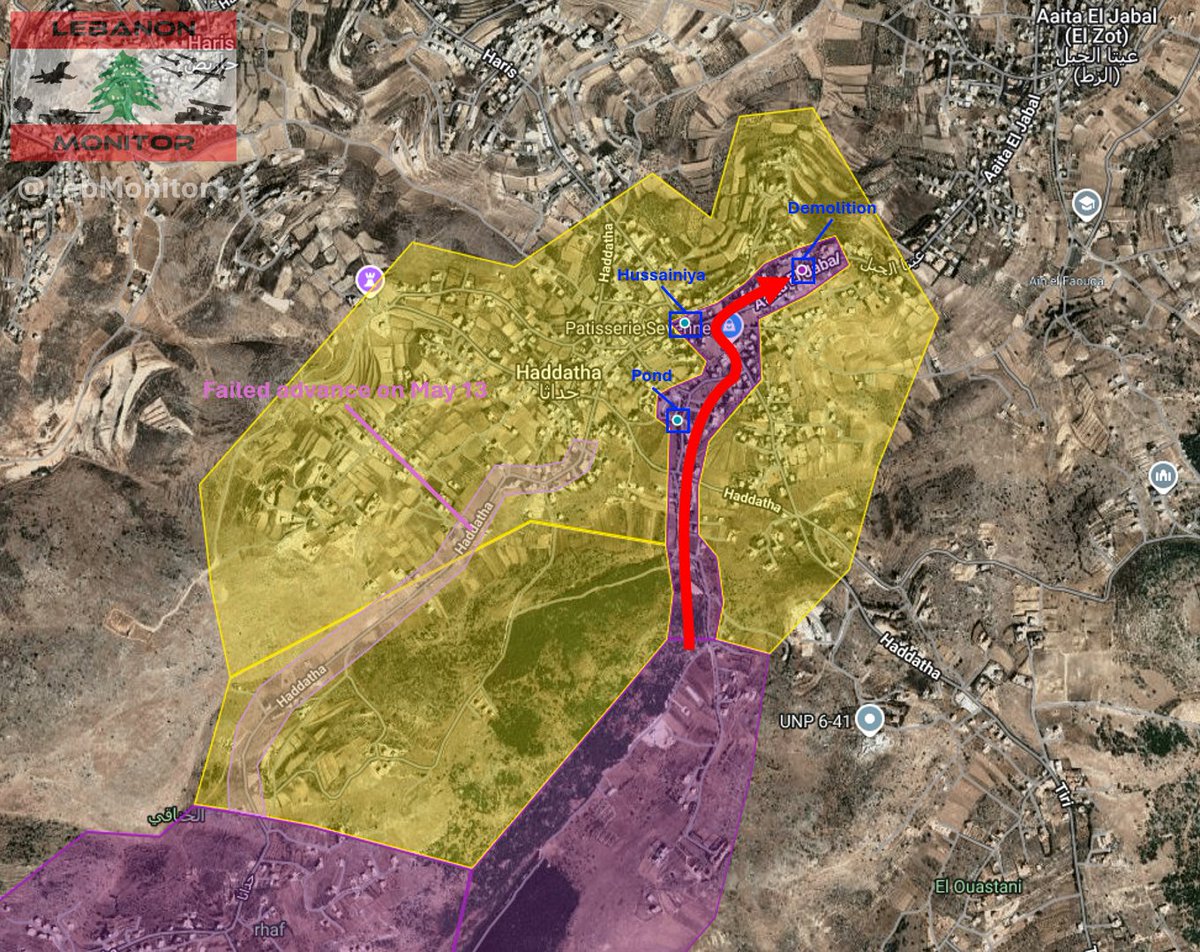
May 20
The IDF launched another attempt at advancing towards Haddatha today.
Based on currently available information, Israeli forces infiltrated towards the eastern parts of the town:
- According to statements from Hezbollah, clashes took place around the Hussainiya.
- Hezbollah also stated that they targeted Israeli positions at the pond.
- I geolocated an image published by Lebanese media which shows what appears to be a controlled demolition in the eastern part of the town.

3
13
68
20,150