
Postdoctoral researcher at Institute of Photogrammetry and Geoinformation @unihannover
Joined February 2011
- Tweets 158
- Following 121
- Followers 246
- Likes 602
28 Photos and videos


Pinned Tweet

12 May 2024
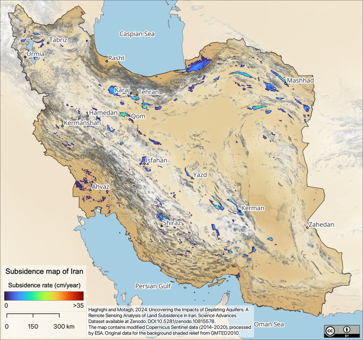
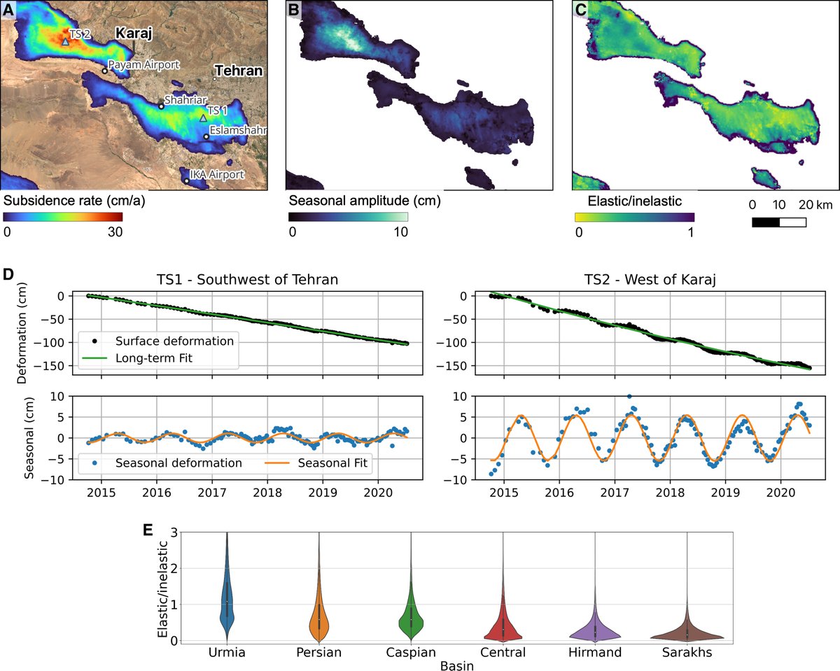
New in @ScienceAdvances. Our paper provides a comprehensive analysis of land subsidence across Iran due to aquifer depletion, using Sentinel-1 InSAR.
#ScienceAdvancesResearch
science.org/doi/10.1126/scia…
2
10
42
27,317
Mahmud Haghshenas retweeted

13 May 2024
A detailed satellite survey of land subsidence in Iran from 2014 to 2020 shows that 3.5% of the country’s land area is subsiding due to groundwater pumping for irrigation. scim.ag/6W6
7
23
3,555
12 May 2024
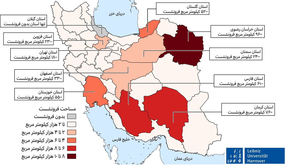
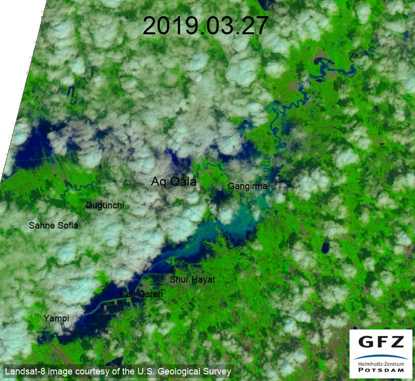
بررسی #فرونشست زمین در سرتاسر ایران. دلیل اصلی فرونشست استخراج بیرویه آبهای زیرزمینی است که متاسفانه به جز گیلان در همه استانهای کشور دیده میشه.
12 May 2024

New in @ScienceAdvances. Our paper provides a comprehensive analysis of land subsidence across Iran due to aquifer depletion, using Sentinel-1 InSAR.
#ScienceAdvancesResearch
science.org/doi/10.1126/scia…
2
5
24
4,899
Mahmud Haghshenas retweeted

12 May 2024
Groundwater loss in Iran is taking on dramatic proportions. In some regions, the ground is sinking almost 40 centimeters per year & huge fissures are opening up. Click here for the news about the latest study of GFZ researcher @MahdiMotagh & his colleague gfz-potsdam.de/en/press/news…
11
22
4,480
Mahmud Haghshenas retweeted
12 May 2024
Grundwasserverlust in Iran nimmt dramatische Ausmaße an. In manchen Regionen senkt sich der Boden deshalb fast 40 Zentimeter pro Jahr und riesige Erdspalten tun sich auf. Hier geht's zu der Nachricht über eine unserer neuesten Studien: gfz-potsdam.de/presse/meldun…
6
8
2,112
12 May 2024
Covering 2014-2020, we found 56,000 km² of Iran's land affected by subsidence, primarily due to excessive groundwater extraction for irrigation. This includes alarming subsidence rates of up to 37 cm/year, posing serious risks to infrastructure and water sustainability.
1
1
11
321
12 May 2024
Our findings reveal that except for Gilan, every province in Iran is experiencing land subsidence at various rates due to groundwater depletion. The nationwide subsidence data is available Access the data at zenodo.org/records/10815578
9
202
12 May 2024
New in @ScienceAdvances. Our paper provides a comprehensive analysis of land subsidence across Iran due to aquifer depletion, using Sentinel-1 InSAR.
#ScienceAdvancesResearch
science.org/doi/10.1126/scia…
2
10
42
27,317
Mahmud Haghshenas retweeted

25 May 2022
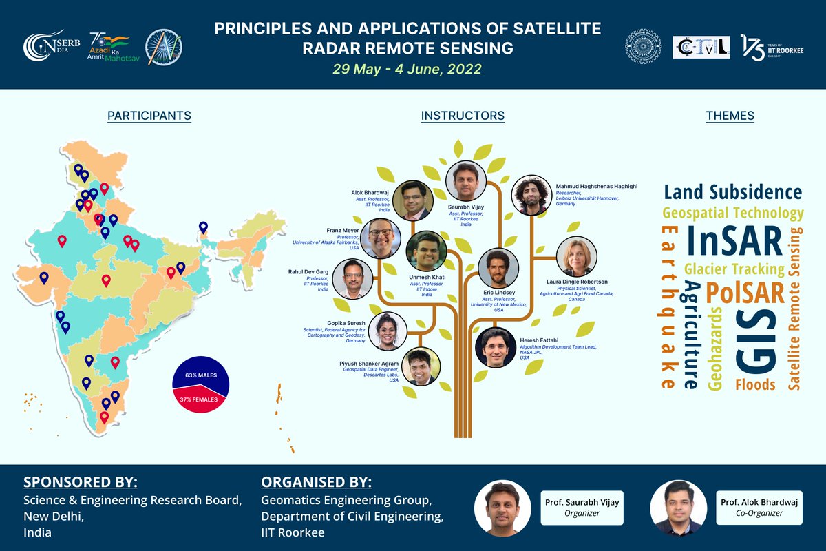
We are all set to organize our FIRST InSAR workshop at the Department of Civil Engineering, IIT Roorkee India. Stay tuned for more updates.
SALIENT FEATURES:
1. SERB sponsored
2. 25 participants (100 applications from 50 Indian universities)
3. 11 SAR experts
3
6
45
Mahmud Haghshenas retweeted

17 Jan 2022
New update on Sentinel-1B - further attempts to activate power were not successful. Investigations on going☹️ scihub.copernicus.eu/news/Ne…
3
15
35
Mahmud Haghshenas retweeted

10 Jan 2022
Things are starting to look serious for Sentinel-1B, which has been down since Christmas. Hopefully ESA can resolve the issues:
scihub.copernicus.eu/news/Ne…
2
10
Mahmud Haghshenas retweeted

26 Nov 2021
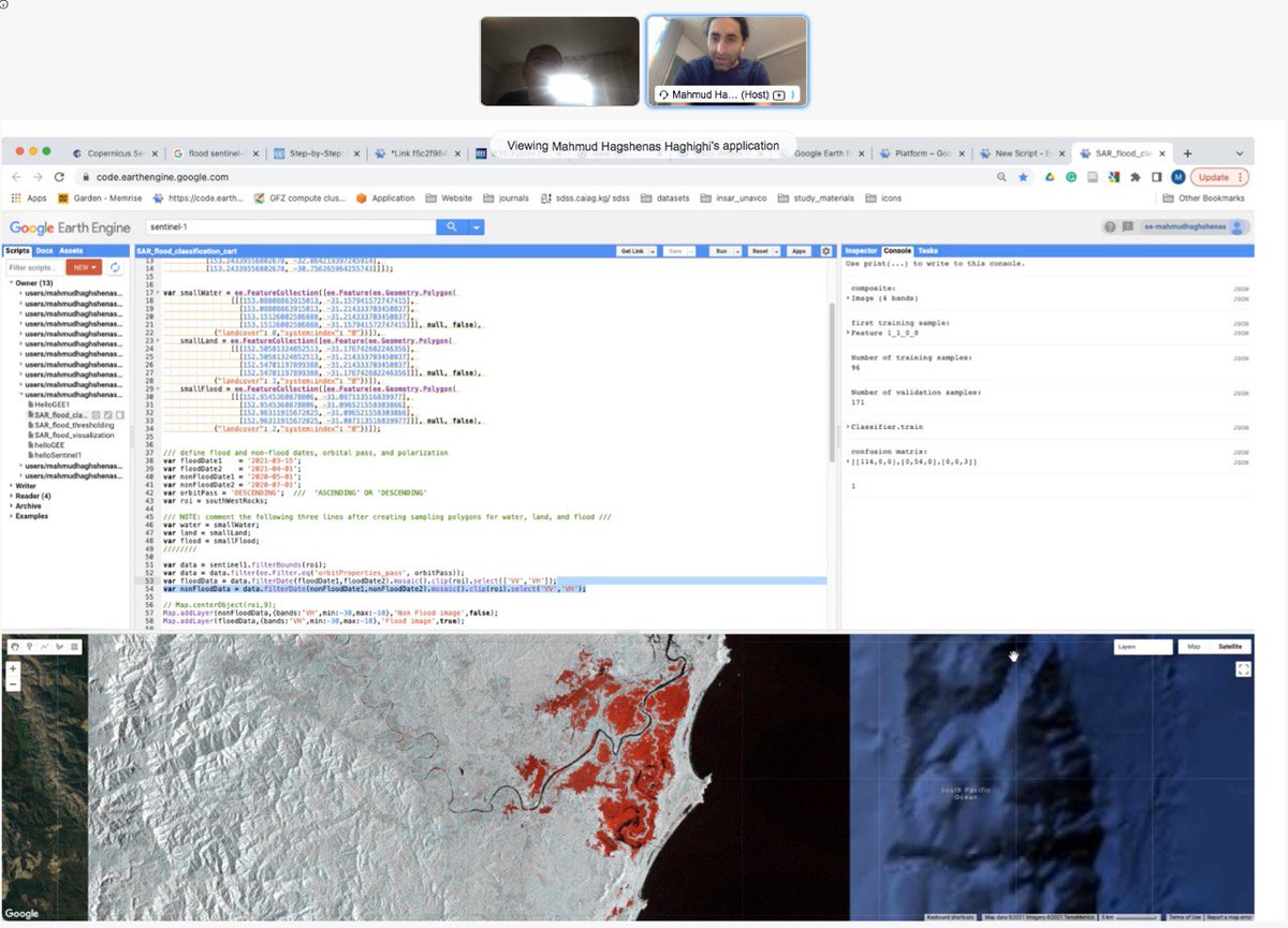
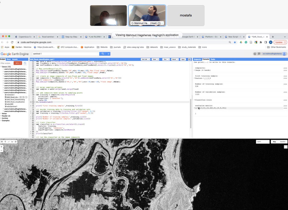
On #BlackFriday our master students at @UniHannover are learning, #online and #offline on the campus, how to use #sentinel1 #SAR data in #GoogleEarthEngine for #landcover #classification and #flood mapping. Thank you @Mahmudhh for your support in the lecture
3
33
Mahmud Haghshenas retweeted

14 Nov 2021
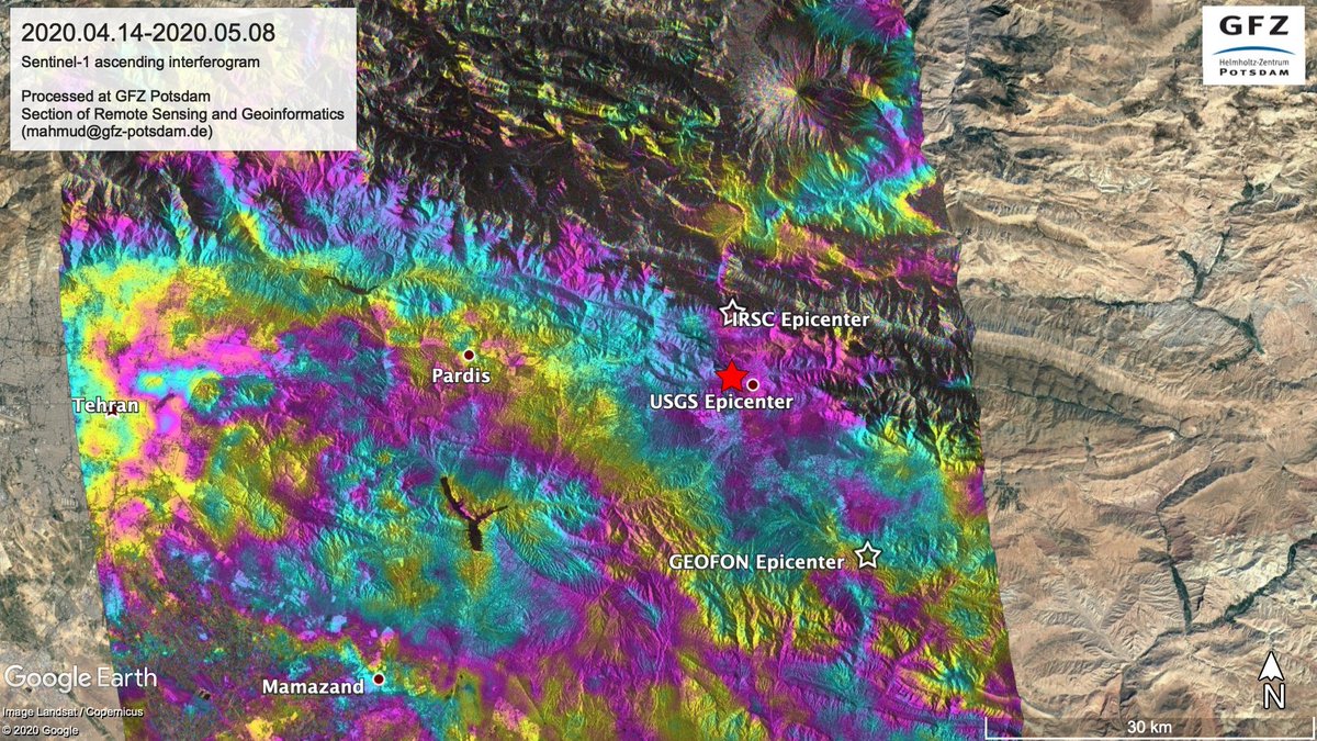
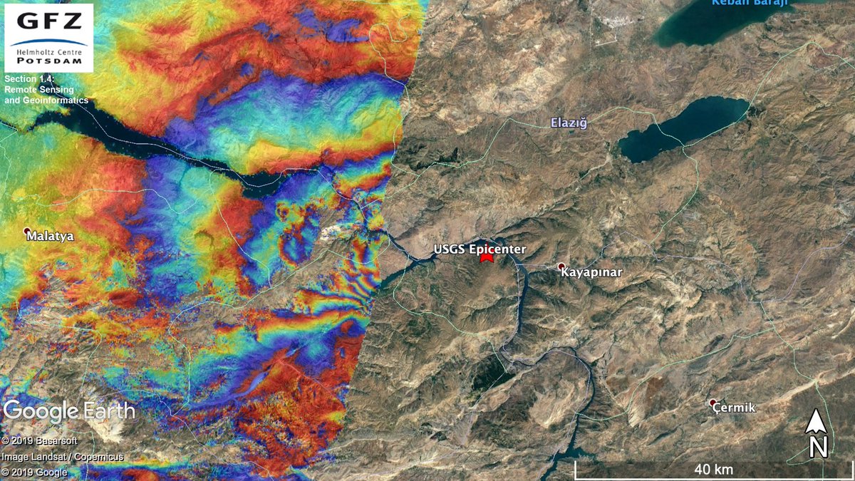
Wow! just got this video! last two #eathquakes M6.0 and M6,3 today, #Iran #Zagros #BandarAbbas #ایران
4
54
220
Mahmud Haghshenas retweeted

8 Jun 2021
Geodetic Colloquium at IGG, Uni Bonn, summer term
igg.uni-bonn.de/de/veranstal…
This Thursday 16:15 CEST=UTC 2h I will be talking about "How (Hydro-) Geodesy Monitors the Global Water Cycle – Results from @GlobalCDA, the DFG-Research Unit 2630" (in English)
8
18
Mahmud Haghshenas retweeted

4 Jun 2021
6-day S1 LiCSAR interferogram for the M7.4 Southern Qinghai earthquake - beautifully highlights shallow afterslip occurring along the fault rupture.
Links to data download from comet.nerc.ac.uk/earthquakes…
@COMET_database @NERC_COMET @ESA_EO
16
43
Mahmud Haghshenas retweeted

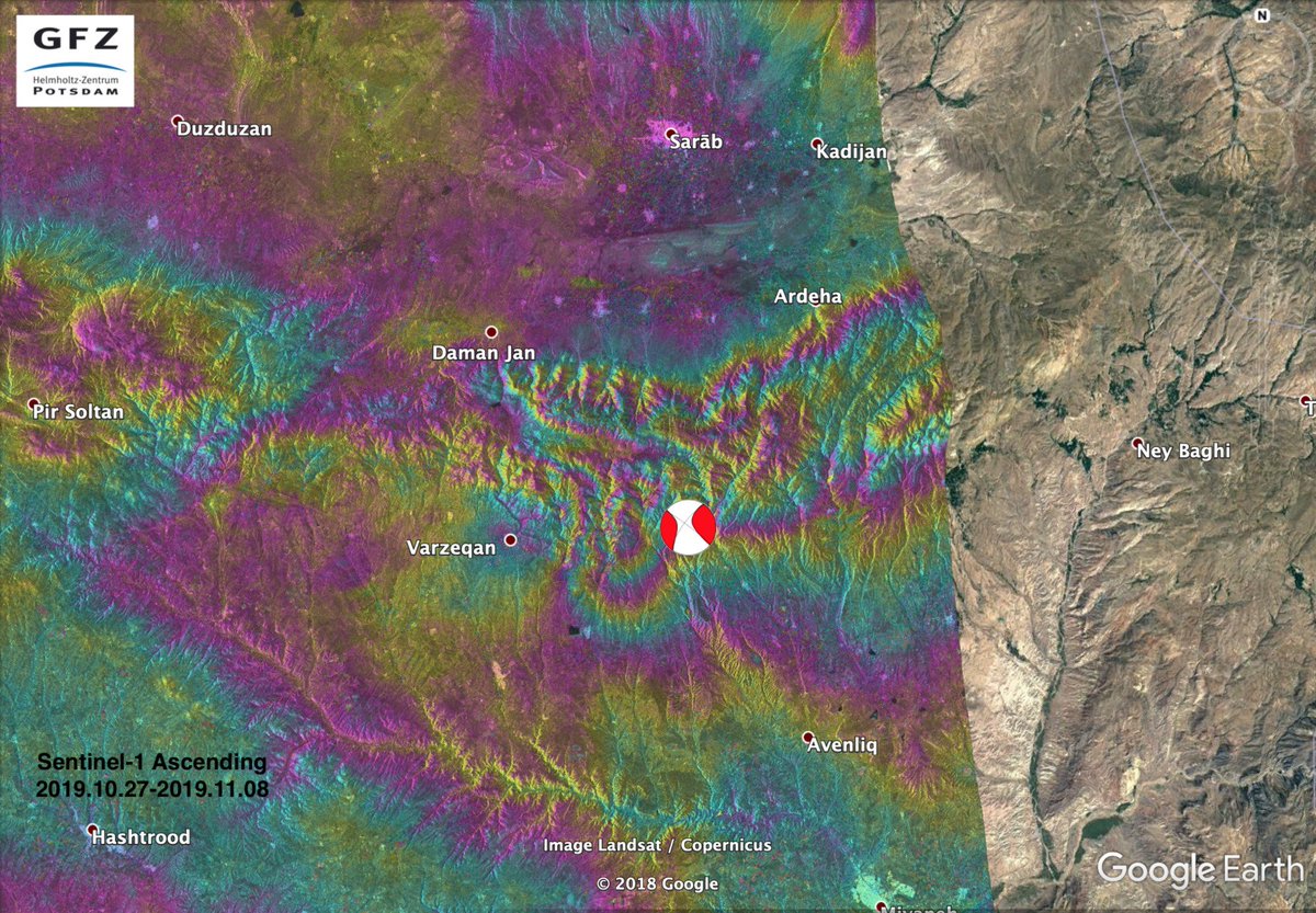
27 May 2021
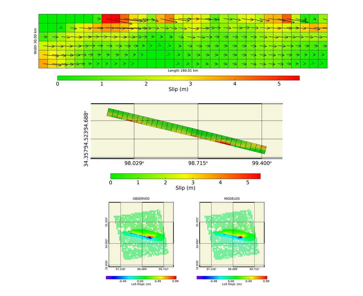
Just because you were curious of a quick 'n dirty model. A North dipping (strike 283°, dip 75°) nearly pure left-lateral (rake -6°) with slip up to 5 m. But high residuals by the fault trace come from unwrapping/coherence issues.
Let's join descending data.
5
5
27 May 2021
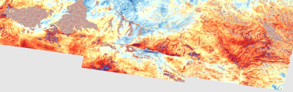
Comparing preseismic and coseismic coherence maps from Sentinel-1 clearly illustrates 170-km-long surface rupture due to Mw 7.3 Southern Qinghai, China earthquake, processed by @esa_gep
4
31
100
Mahmud Haghshenas retweeted

20 Mar 2021
Did we see it coming in InSAR? Well, both yes and no. The dike deformation is clear in sequences of descending (top) and ascending (bottom) S1 interferograms, but there is no short term deformation warning in the last one (up to ~14 hrs before the eruption). Adriano@CDI-KAUST

6
38
131
Mahmud Haghshenas retweeted

20 Mar 2021
Also: Happy Spring & #Nowruz! Happy New Year to all of those who celebrate it. I hope the new year & spring bring everyone peace, prosperity, & happiness. 🧩😃🌱
2
5
Mahmud Haghshenas retweeted

20 Mar 2021
The #fagradalsfjalleruption has started! This is one of the first videos of the eruption taken from a scientific helicopter surveillance flight. Erupting fissure is approx 5-700m long in a valley in central Fagradalsfjall.
8
147
395