
New Zealand's weather service. Helping Kiwi's be ready, whatever the weather.
Joined December 2008
- Tweets 53,741
- Following 1,418
- Followers 147,681
- Likes 11,776
26,660 Photos and videos


☀️Lunch is served South Island☀️
👉It's a settled weather sandwich 🥪
Take a bite while you can, because it won't last for long. And North Island, get hungry because it's coming for you too 😎
For your forecast check here: metservice.com/
6
593
🚌Rainband just in time for the Auckland morning commute!🚇
🌧️A front bringing rain is continuing to march 🪖across the North Island this morning. The band isn't too wide, so a period of rain can be expected followed by some showers, gradually easing with a 'fining up' 🌤️ trend to the rest of the day.
Check your forecast here 👉metservice.com/national
2
6
880
#Christchurch, can you relate to our man Shaq here?
🌡️ Maximum temperature for the day happened at 3am!
This was due to a temporary warm nor-west wind, which tried to come back at 5:30am just before the cold southerly air arrived.
3
2
18
2,156
😵💫 Last time Shaq and I checked, temperatures increase during the day and cool off at night, but at times like this when wind is the main driver of the temperature, anything can happen!
📉 Here's the whole graph showing how the cold southerlies have completely cancelled out any daytime warming.
6
1,205

Jun 14
🛏️😴 When the temperature can't be bothered getting up in the morning and decides to chill all day instead 🥶
📉 Most places in the South Island have already had their maximum temperature for the day before the sun rose, due to cold air coming in from the south.
⬆️ The North Island had some much warmer than average temperatures last night for June, but tonight will go back to normal colder temperatures once those southerly winds arrive.
1
12
1,745
Jun 14
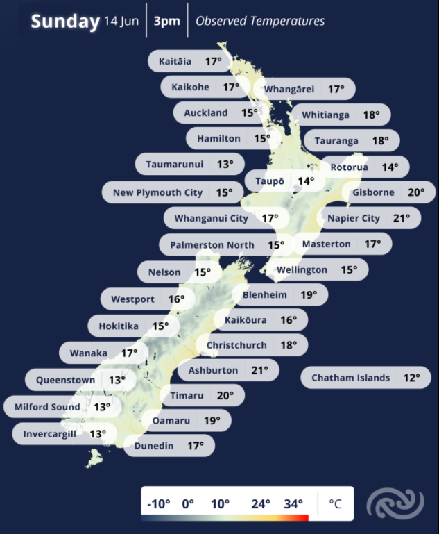
Wondering how warm it is where you are? 📈
Here are our observed temperatures at 3pm. 👇
More info: metservice.com
1
6
1,922
Jun 13
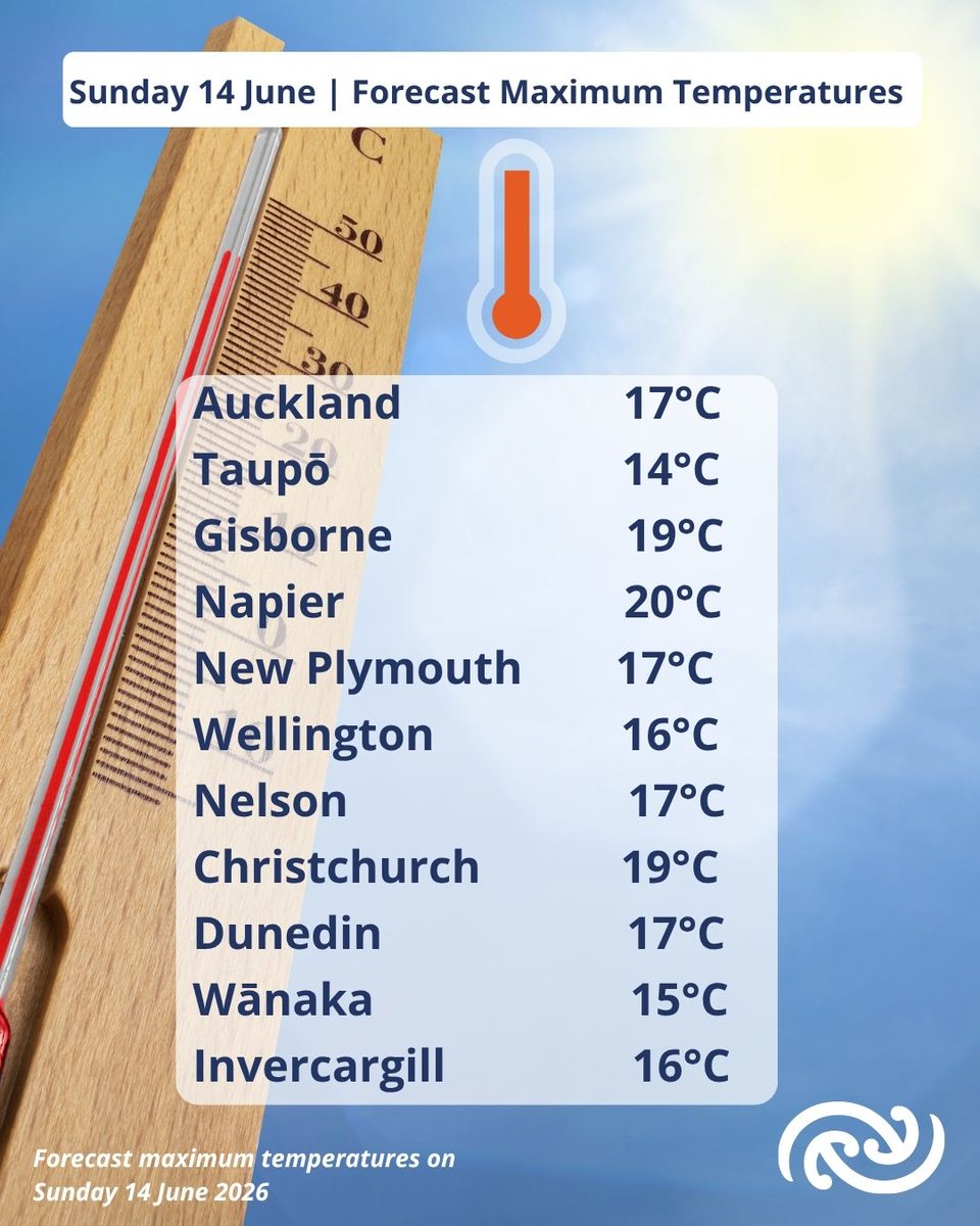
Temps are on the rise! 🌡️🚀
After a few chilly days, temperatures are forecast to shoot up today with Napier forecast to reach 20C, that's 5C above average!
Why? Strengthening northwesterlies are helping to draw warmer air across the country.
Find your latest forecast: metservice.com
2
15
2,007
Jun 13
Your Sunday forecast...
Strengthening northwesterly winds for central and southern regions with a Strong Wind Watch for Canterbury High Country and the Plains near the foothills where winds may approach severe gale in exposed places. 💨
A band of rain spreading onto the southern South Island with heavy rain for the southwest, with Heavy Rain Watches for northern Fiordland and the ranges of Westland. 🌧️
Elsewhere, fine in the east after any fog has lifted and cloudier in the west with a few showers. 😶🌫️ ☀️🌦️
Temperatures on the rise today, many places warmer than average. Highs of 17C for Auckland and Dunedin, 16C for Wellington and Invercargill and 18C for Christchurch. 🌡️
Latest forecast: metservice.com
1
11
1,554
Jun 13
What's in store for the remainder of the weekend?
- Settled with high pressure still in charge for the North Island.
- Morning fog patches possible.
- More rain for the west coast of the South Island on Sunday.
- Temperatures on the rise through Sunday with a building northwesterly wind.
Latest forecasts: metservice.com
3
9
2,055
Jun 12
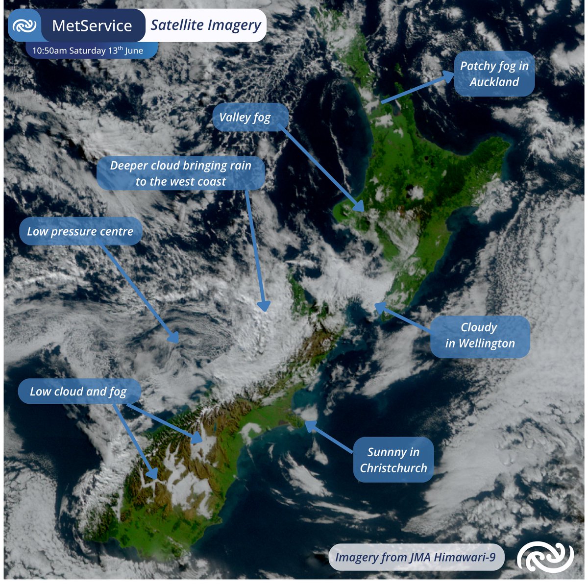
What's the current weather? 🔍🛰️
Lots of clear skies, although areas of low cloud or fog are taking their time to clear. As we head towards the winter solstice, we have less incoming solar energy to our part of the world, so cloud takes longer to lift and clear.
It's cloudier for central and southwestern regions. Can you see the deeper cloud bubbling up on the west coast? That's bringing rain to Hokitika at the moment.
Latest satellite imagery: metservice.com/maps-radar/sa…
2
11
1,523
Jun 12
It's a foggy start for some today. Auckland has been seeing (or not seeing 😂) plenty of fog! So has Masterton. ⬇️ This will gradually lift and clear with increasing daytime temperatures.
Find our forecasts here: metservice.com
1
10
1,573
Jun 12
Auckland's air temperature warmed slightly overnight. How does that happen? 📷
The diagram below shows temperatures from two different nights in Auckland this week.
📷 Blue line = Wednesday night (clear skies)
📷 Yellow line = Thursday night (cloudy skies)
Notice how, toward midnight, the temperatures follow very different paths. The yellow line (cloudy night) levels off and even rises slightly, while the blue line (clear night) continues to cool until around sunrise.
So what's happening?
During the day, the ground absorbs energy from the Sun and warms up. At night, that heat is gradually released back into the atmosphere and out towards space.
On cloudy nights, clouds act a bit like a blanket, absorbing and re-radiating some of that heat back towards the surface. This slows the cooling process and can even allow temperatures to rise slightly overnight if warmer air is mixed down from above.
That's why Auckland was slightly warmer under cloud cover than it was beneath clear skies the night before.
1
1
20
2,492
Jun 11
A haunting beauty over Queenstown/Tāhuna this morning 🩶🤍💙queenstown.roundshot.com/#/
1
1
18
2,219
Jun 11
We’ve seen touches of winter for many regions this week, with frosty conditions and noticeably cooler overnight temperatures. Christchurch and Auckland have reached their lowest temperatures for the year, with –2.7°C and 0.3°C respectively recorded at their airports. ❄️☀️🌡️
Even Northland, Auckland, Bay of Plenty, and the Coromandel, areas that are usually too warm to see frost, will see some patches.
This is due to a high pressure system that remains the dominant feature through much of the weekend, bringing generally settled conditions to most regions. This should provide a settled end to the Fieldays event and generally favourable conditions for the Warriors’ clash against the Sharks on Saturday evening in Auckland🏉
Up the Wahs!
2
16
2,082
Jun 10
Another nice day for Whakatāne! It was a frosty start for many, but the sun is here to warm everything up. Maybe warm enough for a certain group of colourful hill-dwellers to come out of a hibernation that's lasted since 2001... ☀️👶 Have a great morning, Aotearoa!
10
1,514
Jun 10
Early afternoon aerial view 🛰️
🔎 It's a sunny day for many! See all the clear sky in the satellite image below ⬇️ You can even make the snow on the Southern Alps! 🏔️
Still cloudy though for those in the southeast of the North Island and the far south of the South Island.
Find your latest forecast: metservice.com
1
3
16
2,427
Jun 9
Swell Forecast (Wednesday to Thursday morning) 🌊
The heavy swell around our coast (above 4 metres) will continue to track to the northeast today and ease around our shorelines as high pressure builds in from the Tasman Sea.
Latest marine forecasts: metservice.com/marine
1
5
1,624
Jun 9
A cold and frosty start for many. Areas with clear overnight skies (without the blanket of cloud) have seen temperatures drop to the low single digits with a few places below freezing! 🥶
If you have seen any frost this morning, please share some photos!
Latest forecasts: metservice.com
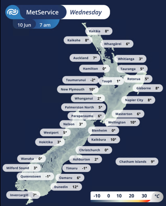
ALT Map of NZ with observed temperatures around the country at 7 am, 10 June 2026.
2
2
13
1,960