
Official X account for National Weather Service Atlanta/Peachtree City. Details: weather.gov/nws_x
- Tweets 23,683
- Following 791
- Followers 74,292
- Likes 4,686


ALT Heat Advisory infographic from the National Weather Service Atlanta for portions of Central and Eastern Georgia, updated June 13, 2026. The left side details the advisory: Timing: Through 8 PM Today (Saturday). Impacts: Heat index values up to 105°F; hazardous heat possible, especially for vulnerable populations. Safety Tips: Icons advise staying hydrated, limiting strenuous outdoor activities during the afternoon, using A/C (fans may not be adequate), and wearing lightweight, light-colored clothing. The right side features a regional weather map. A bright orange highlighted section covers central and eastern Georgia—including Columbus, Macon, Dublin, and areas just south of Atlanta and Athens—marking the Heat Advisory Area. Top right text directs to www.weather.gov/atlanta for the latest forecast information.
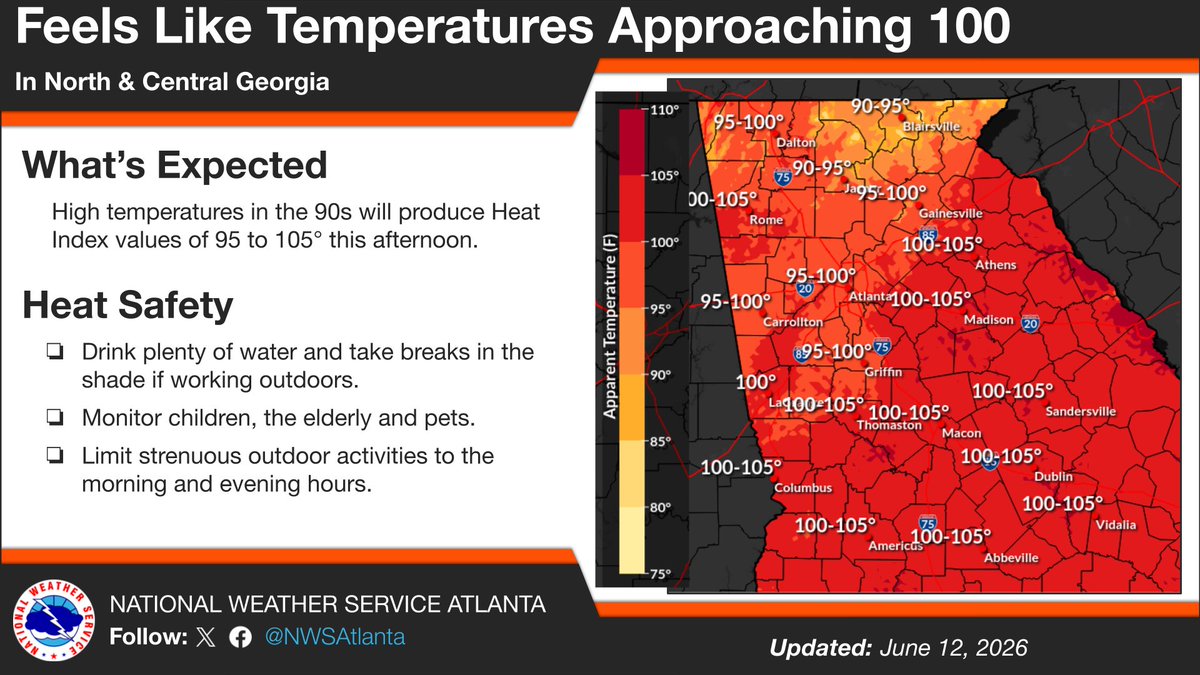
ALT Image of Heat Index Values over north and central Georgia on the right, with heat safety tips on the left.

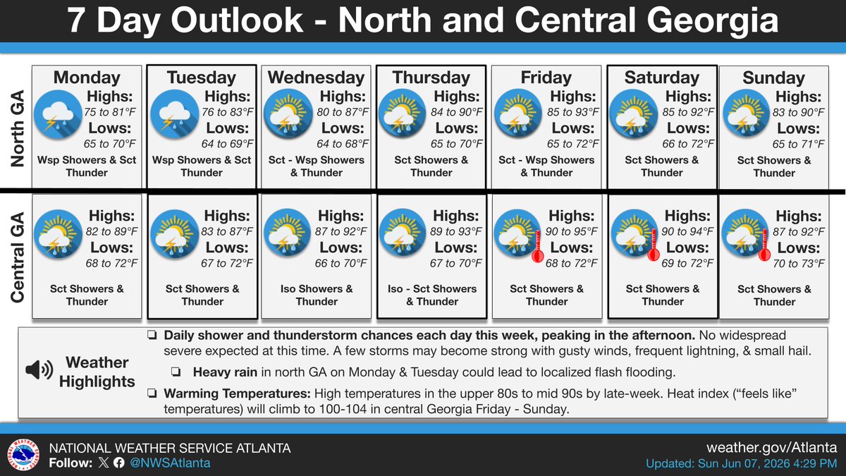
ALT On the left, a chart of rain chances through the weekend. On the right, forecast details.
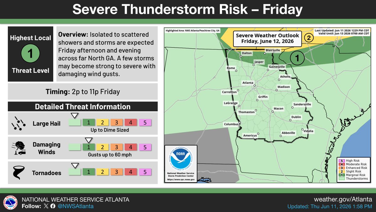
ALT On the left, forecast details. On the right, a map of the severe weather outlook.

ALT This graphic has a map illustrating the weather pattern on the right and details about the heat concerns on the left.

ALT This graphic displays a flash flood warning plotted on a map. The warning is in effect until 12:00 AM EDT. The warning includes Cedartown GA and Cave Spring GA. This warning is for South Central Floyd County in northwestern Georgia and Northwestern Polk County in northwestern Georgia. Avoid walking or driving through flood waters! Move immediately to higher ground! There are 21,578 people in the warning along with 8 schools and 1 hospital.

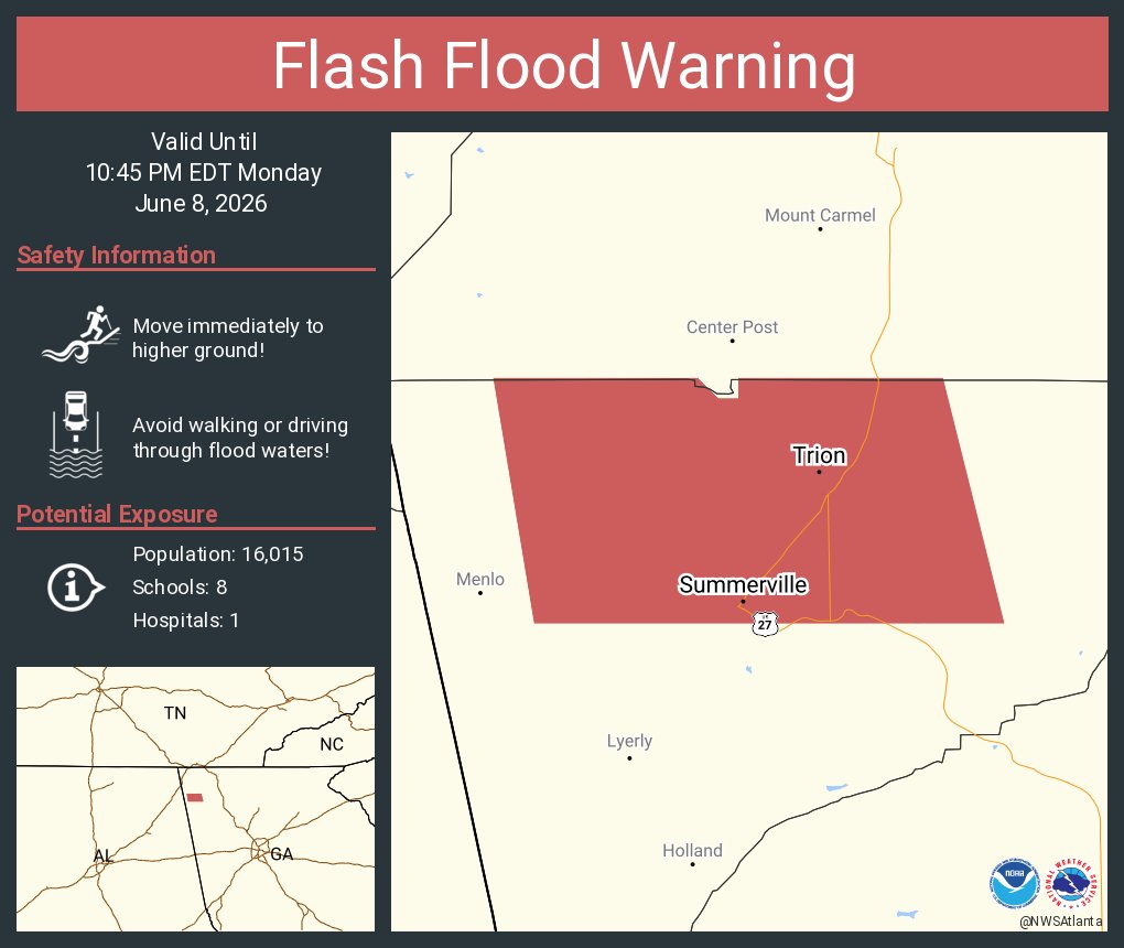
ALT This graphic displays a flash flood warning plotted on a map. The warning is in effect until 10:45 PM EDT. The warning includes Summerville GA and Trion GA. This warning is for Northwestern Chattooga County. Avoid walking or driving through flood waters! Move immediately to higher ground! There are 16,015 people in the warning along with 8 schools and 1 hospital.

ALT This graphic displays a flash flood warning plotted on a map. The warning is in effect until 10:45 PM EDT. The warning includes Summerville GA and Trion GA. This warning is for Northwestern Chattooga County in northwestern Georgia. Avoid walking or driving through flood waters! Move immediately to higher ground! There are 16,015 people in the warning along with 8 schools and 1 hospital.

ALT This graphic displays a flash flood warning plotted on a map. The warning is in effect until 10:15 PM EDT. The warning includes Henderson GA. This warning is for Southwestern Houston County in central Georgia and Northeastern Macon County in west central Georgia. Avoid walking or driving through flood waters! Move immediately to higher ground! There are 2,966 people in the warning along with 0 schools and 0 hospitals.
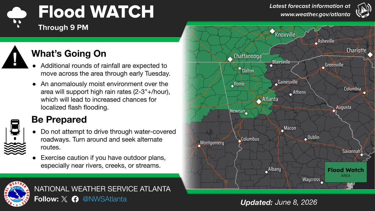
ALT A graphic highlighting the flood watch area on the right. Detailed information about the watch on the left includes what the expected conditions are as well as important safety tips when dealing with flooding.
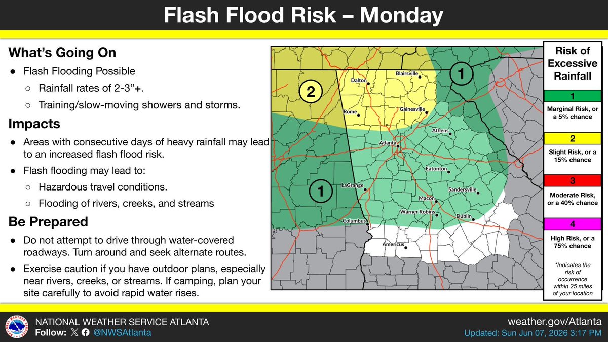
ALT The graphic has a map on the right highlighting the primary flood risk area. Detailed information about what to expect, including flash flood risk and preparation tips, are listed on the left.


ALT On the left is an image highlighting the return of hot temperatures. On the right is text describing these trends.
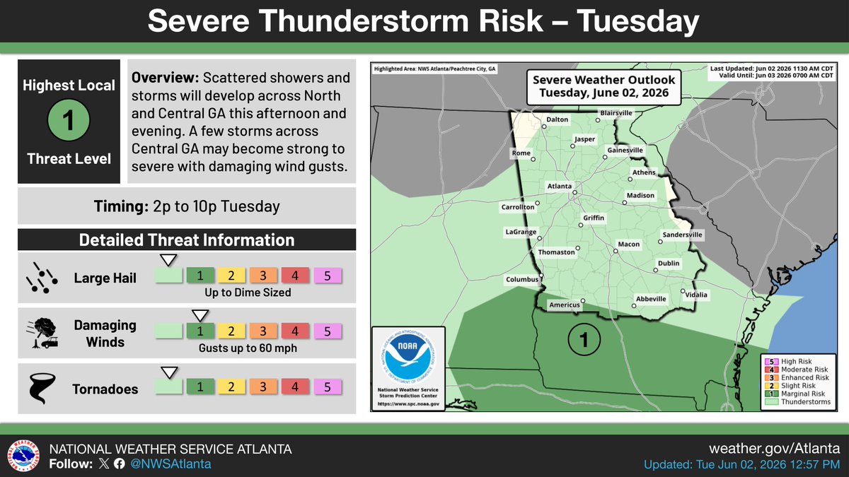
ALT On the left, forecast details. On the right, a map of the severe weather outlook for the day.

ALT This graphic displays a severe thunderstorm warning plotted on a map. The warning is in effect until 7:30 PM EDT. The warning includes Lumpkin GA, Buena Vista GA and Ellaville GA. This warning is for South Central Talbot and Southwestern Taylor Counties Is Cancelled. The threats associated with this warning are wind gusts up to 60 MPH and penny sized hail. There are 15,931 people in the warning along with 10 schools and 1 hospital.
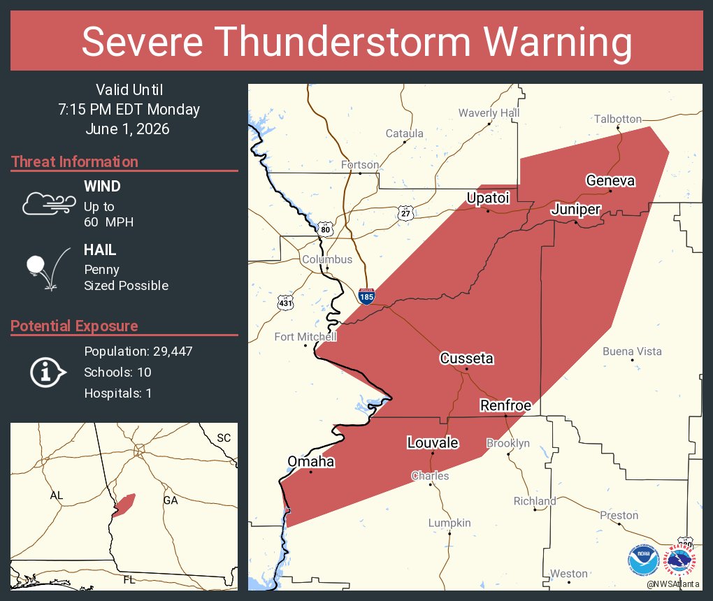
ALT This graphic displays a severe thunderstorm warning plotted on a map. The warning is in effect until 7:15 PM EDT. The warning includes Geneva GA, Cusseta GA and Renfroe GA. This warning is for Harris County Is Cancelled. The threats associated with this warning are wind gusts up to 60 MPH and penny sized hail. There are 29,447 people in the warning along with 10 schools and 1 hospital.
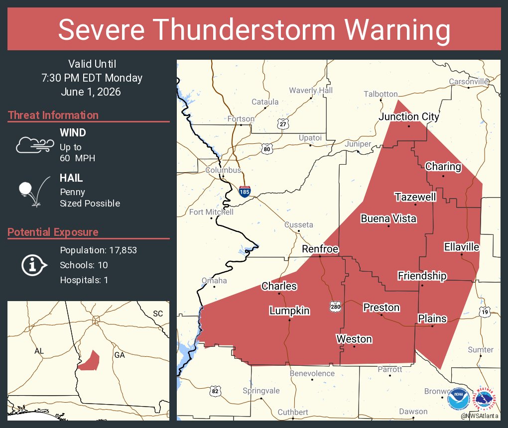
ALT This graphic displays a severe thunderstorm warning plotted on a map. The warning is in effect until 7:30 PM EDT. The warning includes Lumpkin GA, Buena Vista GA and Ellaville GA. This warning is for Marion County in west central Georgia, Southeastern Chattahoochee County in west central Georgia, Stewart County in west central Georgia, Webster County in west central Georgia, Schley County in west central Georgia, Western Sumter County in west central Georgia, South central Talbot County in west central Georgia and Southwestern Taylor County in west central Georgia. The threats associated with this warning are wind gusts up to 60 MPH and penny sized hail. There are 17,853 people in the warning along with 10 schools and 1 hospital.