
Official X Account for National Weather Service Cleveland, Ohio. Details: weather.gov/nws_x
- Tweets 27,746
- Following 555
- Followers 51,788
- Likes 20,134
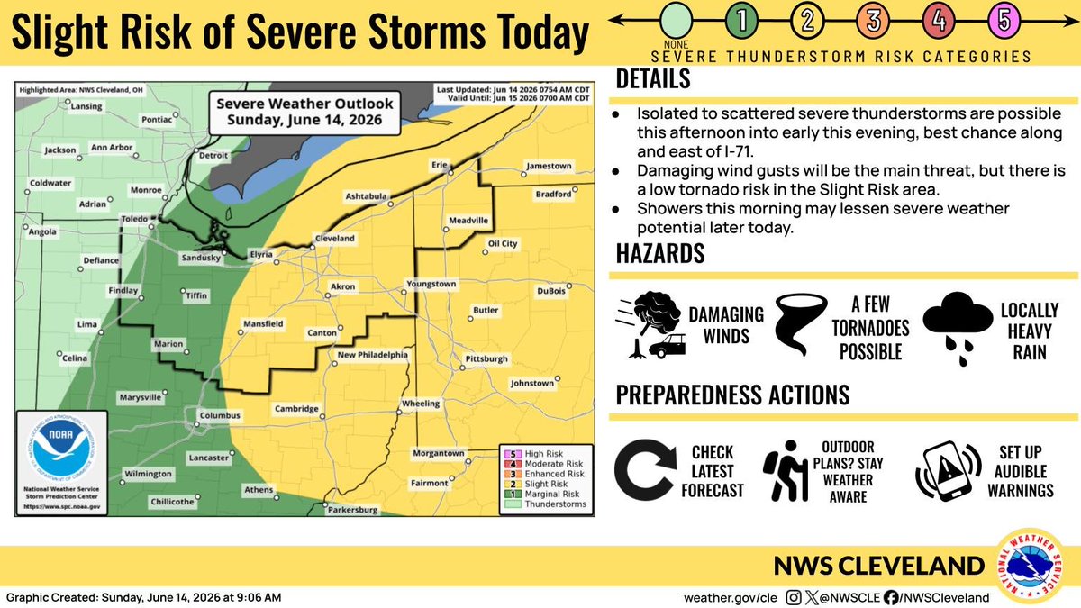


ALT Graphic with today's severe weather outlook for the area on the left and details on the right. Details: Isolated to scattered severe storms are possible this afternoon and early this evening, best chance along and east of I-71. Damaging wind gusts will be the main threat, but there is a low tornado risk in the Slight Risk area. Showers this morning may lessen severe weather potential later today. Hazards: Damaging winds, a few tornadoes possible, locally heavy rain Preparedness Actions: Check the latest forecast, stay weather aware if you have outdoor plans, set up audible warnings
ALT Graphic with today's severe weather outlook for the area on the left and details on the right. Details: Isolated to scattered severe storms are possible this afternoon and early this evening, best chance along and east of I-71. Damaging wind gusts will be the main threat, but there is a low tornado risk in the Slight Risk area. Showers this morning may lessen severe weather potential later today. Hazards: Damaging winds, a few tornadoes possible, locally heavy rain Preparedness Actions: Check the latest forecast, stay weather aware if you have outdoor plans, set up audible warnings

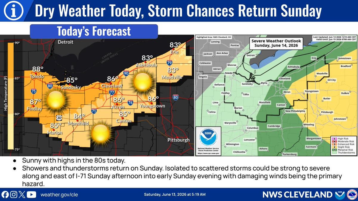
ALT Graphic with the forecast for today on the left and the severe weather outlook for Sunday on the right. Expect dry weather and sunny skies with highs in the 80s today. On Sunday, there is a Marginal Risk of severe weather along and east of Interstate 71 with a Slight Risk across interior Northeast Ohio and Northwest Pennsylvania.
ALT Graphic with low temperatures tonight on the left and high temperatures Saturday on the right.
ALT Graphic with the forecast through Sunday. Cooler today with decreasing clouds. Sunny and warm Saturday. Scattered showers expected and thunderstorms possible as the next cold front moves across the area Sunday.
ALT Title: We Want Your Storm Reports! Sharing your severe weather reports can provide vital information to help improve our ability to warn the public. Wind: large tree branches down, uprooted trees, damage to buildings/cars, power lines down
ALT This graphic displays a special marine warning plotted on a map. The warning is in effect until 4:00 AM EDT. The warning includes Willowick to Geneva-on-the-Lake OH beyond 5NM off shoreline to US-Canadian border, Conneaut OH to Ripley NY beyond 5 nm off shoreline to US-Canadian border, Conneaut OH to Ripley NY and Willowick to Geneva-on-the Lake OH. The threats associated with this warning are wind gusts greater than 40kts and no hail expected.Waterspouts are not expected. Steep waves can be expected. Seek safe harbor and take protective actions.
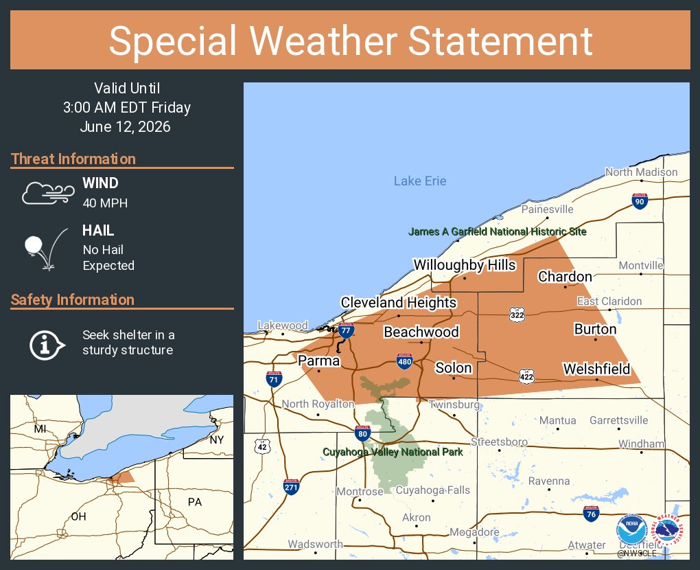
ALT This graphic displays a special weather statement plotted on a map. The statement is in effect until 3:00 AM EDT. The statement includes Parma OH, Cleveland Heights OH and Garfield Heights OH. A STRONG THUNDERSTORM WILL IMPACT GEAUGA and EASTERN CUYAHOGA AND SOUTHWESTERN LAKE COUNTIES THROUGH 300 AM EDT. The threats associated with this storm are wind gusts up to 40 MPH and no hail is expected. Seek shelter in a sturdy structure until the storm passes.
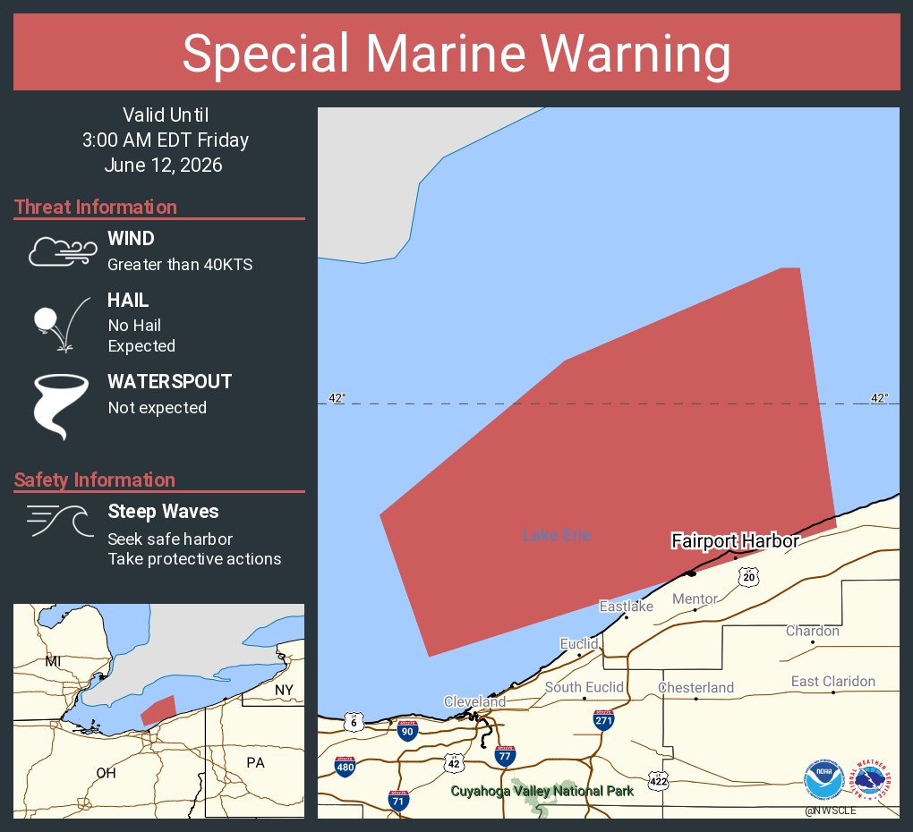
ALT This graphic displays a special marine warning plotted on a map. The warning is in effect until 3:00 AM EDT. The warning includes Willowick to Geneva-on-the-Lake OH beyond 5NM off shoreline to US-Canadian border, Avon Point to Willowick OH beyond 5 nm off shoreline to US-Canadian border and Willowick to Geneva-on-the Lake OH. The threats associated with this warning are wind gusts greater than 40kts and no hail expected.Waterspouts are not expected. Steep waves can be expected. Seek safe harbor and take protective actions.
ALT This graphic displays a special weather statement plotted on a map. The statement is in effect until 2:15 AM EDT. The statement includes Mansfield OH, Mount Vernon OH and Galion OH. GUSTY SHOWERS WILL IMPACT SOUTHERN RICHLAND, NORTHEASTERN MARION, SOUTHERN ASHLAND, MORROW and SOUTHEASTERN CRAWFORD AND KNOX COUNTIES THROUGH 215 AM EDT. The threats associated with this storm are wind gusts up to 50 MPH and no hail is expected. Seek shelter in a sturdy structure until the storm passes.
ALT This graphic displays a special weather statement plotted on a map. The statement is in effect until 2:15 AM EDT. The statement includes Toledo OH, Oregon OH and Fremont OH. The threats associated with this storm are wind gusts up to 50 MPH and no hail is expected. Seek shelter in a sturdy structure until the storm passes.
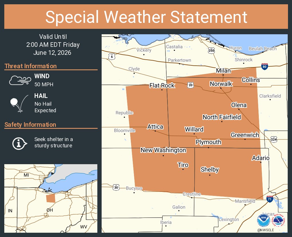
ALT This graphic displays a special weather statement plotted on a map. The statement is in effect until 2:00 AM EDT. The statement includes Norwalk OH, Shelby OH and Willard OH. The threats associated with this storm are wind gusts up to 50 MPH and no hail is expected. Seek shelter in a sturdy structure until the storm passes.
ALT This graphic displays a special weather statement plotted on a map. The statement is in effect until 1:30 AM EDT. The statement includes Marion OH, Cardington OH and Prospect OH. The threats associated with this storm are wind gusts up to 50 MPH and no hail is expected. Seek shelter in a sturdy structure until the storm passes.
ALT This graphic displays a severe thunderstorm warning plotted on a map. The warning is in effect until 1:30 AM EDT. The warning includes Tiffin OH, Bucyrus OH and Upper Sandusky OH. This warning is for Seneca County in northwestern Ohio, Wyandot County in northwestern Ohio, Southern Sandusky County in northwestern Ohio and Western Crawford County in north central Ohio. The threats associated with this warning are wind gusts up to 60 MPH and pea sized hail. There are 111,211 people in the warning along with 55 schools and 4 hospitals.
ALT This graphic displays a special marine warning plotted on a map. The warning is in effect until 2:00 AM EDT. The warning includes Reno Beach to The Islands OH, Reno Beach to The Islands OH beyond 5NM off shoreline to US-Canadian border, The Islands to Vermilion OH and Maumee Bay to Reno Beach OH. The threats associated with this warning are wind gusts greater than 49kts and no hail expected.Waterspouts are not expected. Steep waves can be expected. Seek safe harbor and take protective actions.
ALT This graphic displays a severe thunderstorm warning plotted on a map. The warning is in effect until 1:15 AM EDT. The warning includes Toledo OH, Bowling Green OH and Perrysburg OH. This warning is for Ottawa County in northwestern Ohio, Northwestern Sandusky County in northwestern Ohio, Wood County in northwestern Ohio and Lucas County in northwestern Ohio. The threats associated with this warning are wind gusts up to 60 MPH and pea sized hail. There are 581,451 people in the warning along with 209 schools and 10 hospitals.
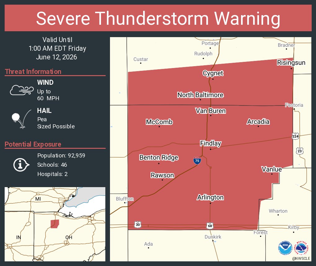
ALT This graphic displays a severe thunderstorm warning plotted on a map. The warning is in effect until 1:00 AM EDT. The warning includes Findlay OH, North Baltimore OH and McComb OH. This warning is for Southern Wood County in northwestern Ohio and Hancock County in northwestern Ohio. The threats associated with this warning are wind gusts up to 60 MPH and pea sized hail. There are 92,959 people in the warning along with 46 schools and 2 hospitals.
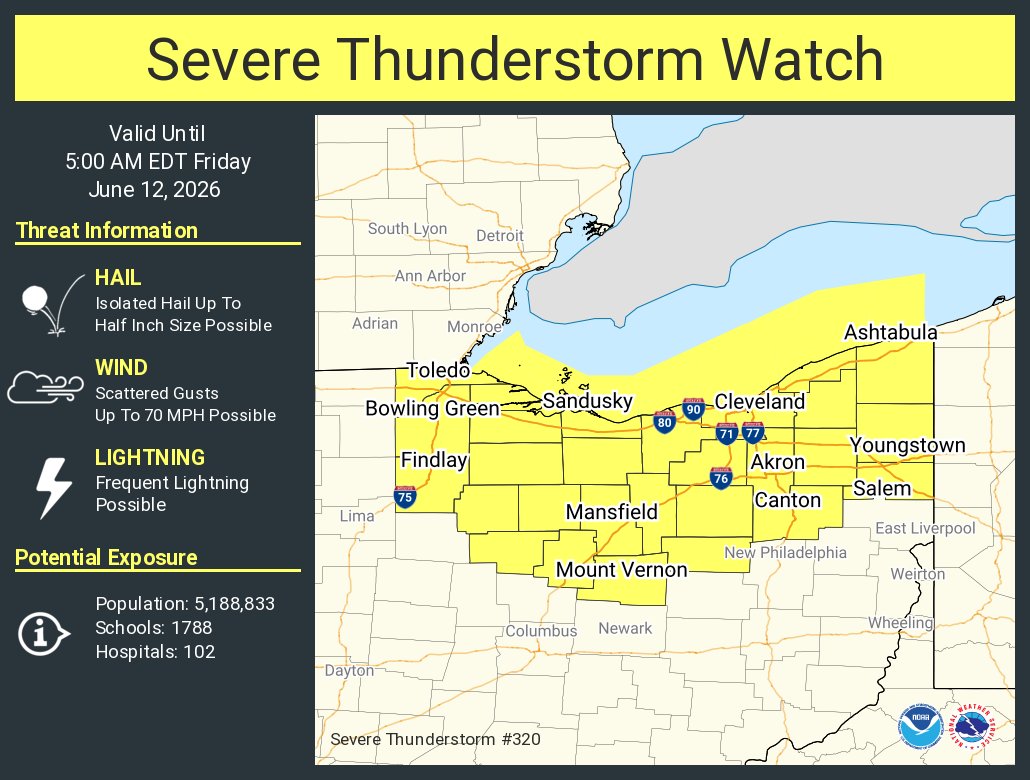
ALT This graphic displays Severe Thunderstorm watch number 320 plotted on a map. The watch is in effect until 5:00 AM EDT. The watch includes parts of Ohio. The threats associated with this watch are no tornadoes expected, isolated hail up to half inch size possible and scattered gusts up to 70 mph possible. There are 5,188,833 people in the watch along with 1788 schools and 102 hospitals.

ALT Graphic showing current marine hazards valid through Friday afternoon. There is small craft advisory for all the nearshore zones with winds increasing to 15 to 25 knots and waves building to 2 to 5 feet. There is also a high risk for rip currents along the lakeshore through Friday afternoon.

ALT This graphic displays a special weather statement plotted on a map. The statement is in effect until 3:00 PM EDT. The statement includes Meadville PA, Corry PA and Titusville PA. STRONG THUNDERSTORMS WILL IMPACT EASTERN ERIE AND CRAWFORD COUNTIES THROUGH 300 PM EDT. The threats associated with this storm are wind gusts up to 50 MPH and no hail is expected. Seek shelter in a sturdy structure until the storm passes.