
- Tweets 49,257
- Following 1,040
- Followers 190,911
- Likes 13,972


ALT This is a multiday forecast graphic for northern Illinois and northwest Indiana. Headline: Five Day Outlook. Sub Headline: Severe Thunderstorms Possible Wednesday. Showers will end from west to east across the area during the mid to late morning. An isolated thunderstorm is possible south of Interstate 80. No severe weather is expected. High temperatures will be much cooler today, mainly in the lower 70s with northwest winds gusting as high as 30 mph. There will be another chance for thunderstorms Tuesday afternoon, a few of these thunderstorms may be strong to severe. Severe thunderstorms are expected across the entire area Wednesday with all severe hazards possible. Torrential rain and localized flooding will also be possible Wednesday. Visit weather.gov/Chicago for more forecast details for your location. Graphic Created: Sunday, June 14, 2026 5:06 AM CDT
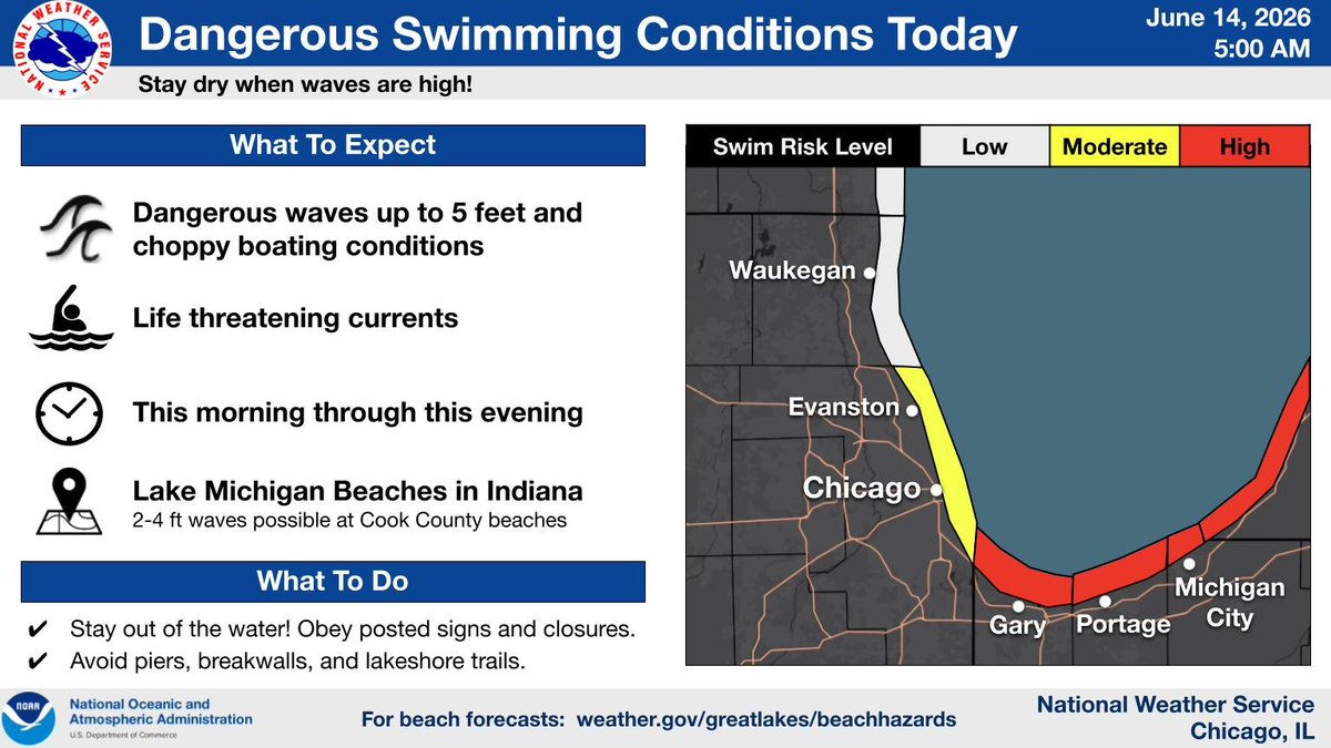
ALT Headline: Dangerous Swimming Conditions Today. Sub Headline: Stay dry when waves are high! What To Expect. Dangerous waves up to 5 feet and choppy boating conditions. Life threatening currents. This morning through this evening. Lake Michigan Beaches in Indiana. 2-4 ft waves possible at Cook County beaches. What To Do. Stay out of the water! Obey posted signs and closures. Avoid piers, breakwalls, and lakeshore trails. For beach forecasts: weather.gov/greatlakes/beachhazards Graphic Created: Sunday, June 14, 2026 5:00 AM CDT
ALT This is a multiday forecast graphic for northern Illinois and northwest Indiana. Headline: Four Day Outlook. Sub Headline: We start the upcoming week cooler with increasing shower and storm chances toward midweek. Visit weather.gov/Chicago for more forecast details for your location. Graphic Created: Saturday, June 13, 2026 4:48 PM CDT
ALT Headline: Dangerous Swimming Conditions Sunday. Sub Headline: Stay dry when waves are high! What To Expect. Dangerous waves up to 5 feet and choppy boating conditions. Life threatening currents. Sunday morning through the evening. Lake Michigan Beaches in Indiana. 2-4 ft waves possible at Cook County beaches. What To Do. Stay out of the water! Obey posted signs and closures. Avoid piers, breakwalls, and lakeshore trails. For beach forecasts: weather.gov/greatlakes/beachhazards Graphic Created: Saturday, June 13, 2026 4:48 PM CDT
ALT Headline: Thunderstorm Threat Through This Evening. Sub Headline: An isolated strong to severe storm can't be ruled out. What To Expect. Isolated to scattered thunderstorms. Severe threat level 1 of 5. Isolated through mid evening. Greater coverage possible after 8 - 9 PM CDT. Localized Downpours. Lightning Strikes. Gusty Winds. What To Do. Move indoors if you hear thunder. Have multiple ways to get weather warnings. Graphic Created: Saturday, June 13, 2026 4:48 PM CDT

ALT Headline: Chance of Storms Today. Sub Headline: Some storms may be strong to severe. Move indoors if you hear thunder. Have multiple ways to get weather warnings. Scattered thunderstorms are possible late this afternoon into this evening. A few of these thunderstorms may be strong to severe. Graphic Created: Saturday, June 13, 2026 4:28 AM CDT
ALT This is a multiday forecast graphic for northern Illinois and northwest Indiana. Headline: Five Day Outlook. Sub Headline: Strong to Severe Thunderstorms Possible Late this Afternoon into this Evening. Scattered thunderstorms are possible late this afternoon into tonight. A few of these thunderstorms may be strong to severe. Showers will continue overnight and into early Sunday morning. High temperatures will reach the mid to upper 80s today then a cold front will move across the area tonight, with highs on Sunday only in the lower 70s. Shower and thunderstorms chances will return Tuesday and Wednesday. Visit weather.gov/Chicago for more forecast details for your location. Graphic Created: Saturday, June 13, 2026 4:14 AM CDT

ALT This is a multiday forecast graphic for northern Illinois and northwest Indiana. Headline: Four Day Outlook. Sub Headline: Strong to Severe Thunderstorms Possible Late Saturday Afternoon and Evening. Visit weather.gov/Chicago for more forecast details for your location. Graphic Created: Friday, June 12, 2026 3:55 PM CDT
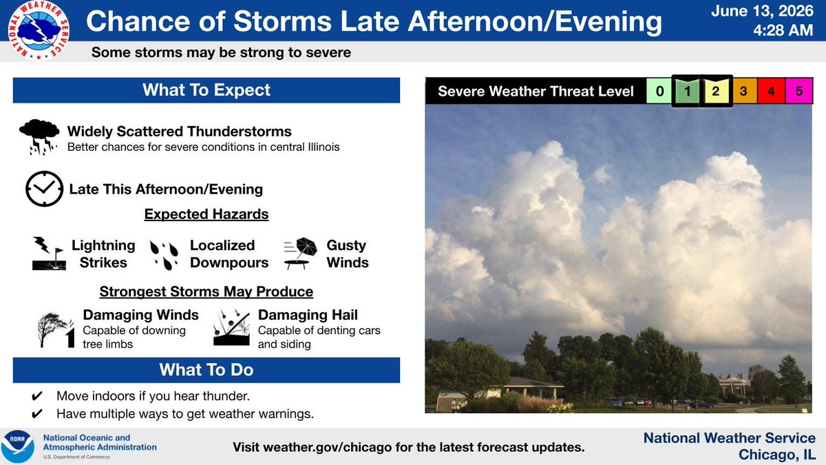
ALT Headline: Another Chance of Storms Tomorrow. Sub Headline: Some storms may be strong to severe.What To Expect: Widely Scattered Thunderstorms with Better chances for severe conditions in central Illinois. Expected Hazards: Localized Downpours. Lightning Strikes. Gusty Winds. Strongest Storms May Produce: Damaging Winds. Capable of downing tree limbs. Damaging Hail. Capable of denting cars and siding. What To Do: Move indoors if you hear thunder. Have multiple ways to get weather warnings. Graphic Created: Friday, June 12, 2026 3:55 PM CDT
