
Official X account for the National Weather Service Des Moines. Details: weather.gov/nws_x
- Tweets 51,591
- Following 932
- Followers 53,721
- Likes 21,449
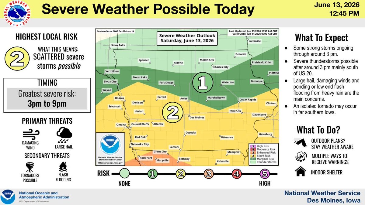


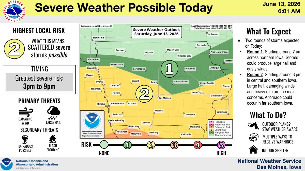


ALT Infographic titled "Severe Storms Possible Today" from the National Weather Service in Des Moines, Iowa, dated June 13, 2026.
ALT This graphic displays a severe thunderstorm warning plotted on a map. The warning is in effect until 12:15 PM CDT. The warning includes Lineville IA and Pleasanton IA. This warning is for Southeastern Decatur County in south central Iowa and Southwestern Wayne County in south central Iowa. The threats associated with this warning are wind gusts up to 60 MPH and quarter sized hail. There are 253 people in the warning along with 2 schools and 0 hospitals.
ALT This graphic displays a severe thunderstorm warning plotted on a map. The warning is in effect until 11:45 AM CDT. The warning includes Lamoni IA, Mount Ayr IA and Diagonal IA. This warning is for Western Decatur County in south central Iowa and Ringgold County in south central Iowa. The threats associated with this warning are wind gusts up to 60 MPH and quarter sized hail. There are 6,409 people in the warning along with 7 schools and 1 hospital.
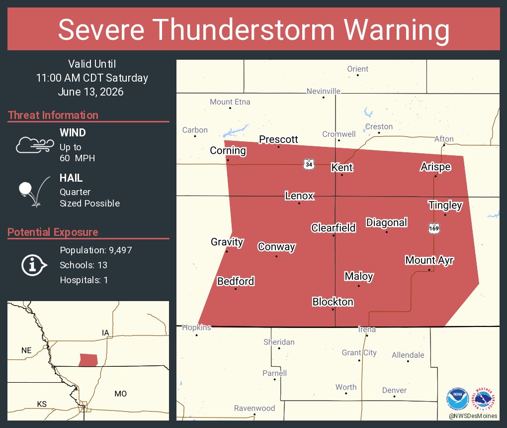
ALT This graphic displays a severe thunderstorm warning plotted on a map. The warning is in effect until 11:00 AM CDT. The warning includes Mount Ayr IA, Corning IA and Bedford IA. This warning is for Southwestern Union County in south central Iowa, Ringgold County in south central Iowa, Southeastern Adams County in southwestern Iowa and Taylor County in southwestern Iowa. The threats associated with this warning are wind gusts up to 60 MPH and quarter sized hail. There are 9,497 people in the warning along with 13 schools and 1 hospital.
ALT This graphic displays a severe thunderstorm warning plotted on a map. The warning is in effect until 10:30 AM CDT. The warning includes Corning IA, Bedford IA and New Market IA. This warning is for Adams County in southwestern Iowa and Taylor County in southwestern Iowa. The threats associated with this warning are wind gusts up to 60 MPH and quarter sized hail. There are 5,349 people in the warning along with 6 schools and 1 hospital.
ALT This graphic displays a severe thunderstorm warning plotted on a map. The warning is in effect until 10:00 AM CDT. The warning includes Atlantic IA, Griswold IA and Lewis IA. This warning is for Western Cass County in southwestern Iowa and Western Adams County in southwestern Iowa. The threats associated with this warning are wind gusts up to 60 MPH and quarter sized hail. There are 10,601 people in the warning along with 9 schools and 1 hospital.
ALT This graphic displays Severe Thunderstorm watch number 326 plotted on a map. The watch is in effect until 3:00 PM CDT. The watch includes parts of Iowa and Missouri. The threats associated with this watch are no tornadoes expected, isolated hail up to ping pong size possible and scattered gusts up to 70 mph possible. There are 373,870 people in the watch along with 286 schools and 29 hospitals.
ALT Infographic titled "Severe Storm Potential Today" from the National Weather Service in Des Moines, Iowa, dated June 13, 2026. The graphic outlines a "Scattered" severe storm risk for Today, with the greatest severe threat timed between 3 PM and 10 PM. Primary threats are listed as large hail and damaging winds, with secondary threats of tornadoes (some strong), small hail, flash flooding, and heavy rain. A map of Iowa highlights the "Highest Local Risk" shaded in yellow across central and southern Iowa, including Des Moines. Text boxes advise the public to stay weather aware if they have outdoor or camping plans, have multiple ways to receive warnings, and know where to find indoor or sturdy shelter.

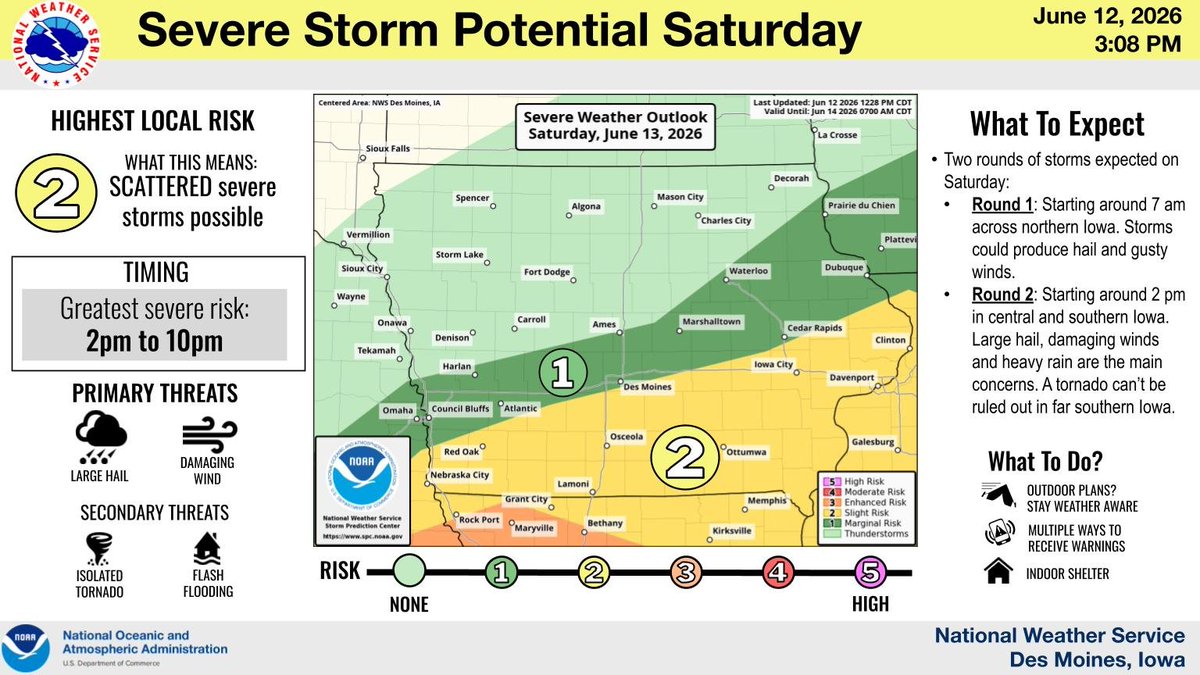
ALT Infographic titled "Severe Storm Potential Saturday" from the National Weather Service in Des Moines, Iowa, dated June 12, 2026. The graphic outlines a "Scattered" severe storm risk for Saturday, with the greatest severe threat timed between 2 PM and 10 PM. Primary threats are listed as large hail and damaging winds, with secondary threats of tornadoes (some strong), small hail, flash flooding, and heavy rain. A map of Iowa highlights the "Highest Local Risk" shaded in yellow across central and southern Iowa, including Des Moines. Text boxes advise the public to stay weather aware if they have outdoor or camping plans, have multiple ways to receive warnings, and know where to find indoor or sturdy shelter.
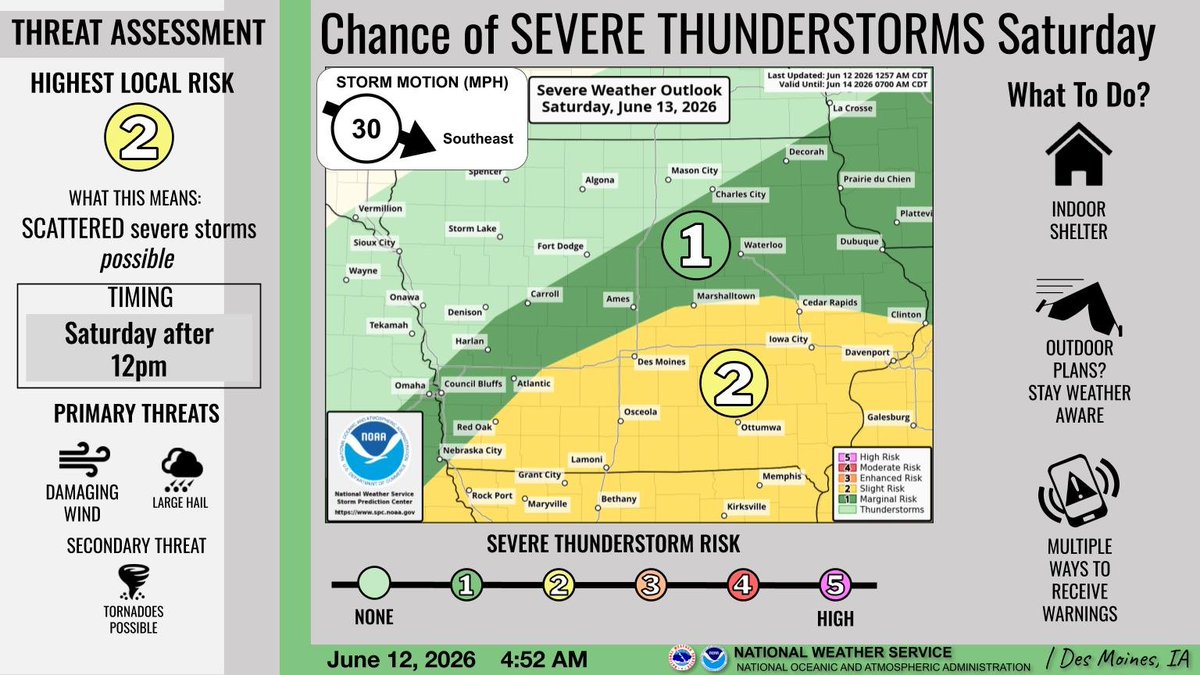
ALT A slight risk (category 2 of 5) for severe weather is forecast for Saturday. Damaging winds and large hail are possible over parts of central and southern Iowa, mainly in the afternoon hours.
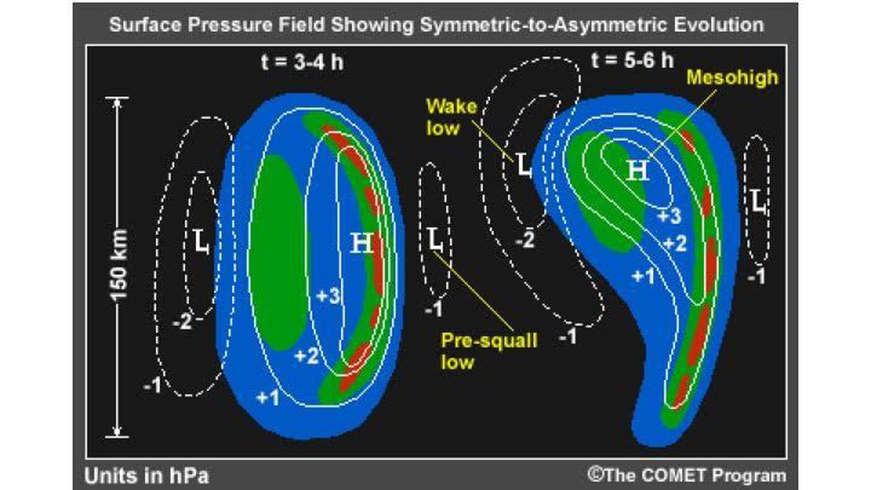
ALT An illustration of the formation of a wake low in a squall line (or line of thunderstorms). White dashed lines is pressure in hectopascals (or millibars) Photo credit to the COMET program.
ALT This graphic displays Tornado Watch watch number 313 plotted on a map. The watch is in effect until 9:00 PM CDT. The watch includes parts of Illinois, Indiana, Iowa, Missouri and Wisconsin. The threats associated with this watch are several tornadoes likely, scattered hail up to tennis ball size possible and widespread gusts up to 80 mph likely. There are 13,489,217 people in the watch along with 4500 schools and 259 hospitals.
ALT Forecast for today, June 11, detailing numerous severe storms before 5PM. Primary hazards are large hail, damaging winds, tornadoes and heavy rain/flash flooding.
ALT This graphic displays a severe thunderstorm warning plotted on a map. The warning is in effect until 9:30 AM CDT. The warning includes Grinnell IA, Tama IA and Toledo IA. This warning is for Southeastern Hardin and Northeastern Marion Counties Is Cancelled. The threats associated with this warning are wind gusts up to 70 MPH and pea sized hail. There are 45,560 people in the warning along with 34 schools and 1 hospital.

ALT This graphic displays a severe thunderstorm warning plotted on a map. The warning is in effect until 9:45 AM CDT. The warning includes Centerville IA, Bloomfield IA and Seymour IA. This warning is for Davis County in southeastern Iowa, Southeastern Wayne County in south central Iowa and Appanoose County in south central Iowa. The threats associated with this warning are wind gusts up to 60 MPH and pea sized hail. There are 20,882 people in the warning along with 21 schools and 2 hospitals.

ALT This graphic displays a severe thunderstorm warning plotted on a map. The warning is in effect until 9:45 AM CDT. The warning includes Waterloo IA, Cedar Falls IA and Waverly IA. This warning is for Eastern Hardin County in central Iowa, Black Hawk County in northeastern Iowa, Bremer County in northeastern Iowa, Southeastern Franklin County in north central Iowa, Grundy County in central Iowa and Butler County in north central Iowa. The threats associated with this warning are wind gusts up to 60 MPH and pea sized hail. There are 182,807 people in the warning along with 80 schools and 6 hospitals.
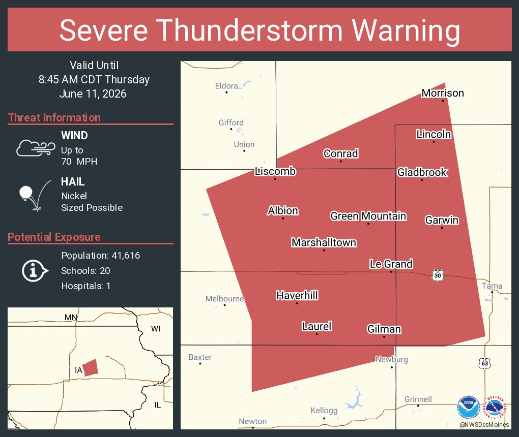
ALT This graphic displays a severe thunderstorm warning plotted on a map. The warning is in effect until 8:45 AM CDT. The warning includes Marshalltown IA, Conrad IA and Gladbrook IA. This warning is for Southeastern Story County Is Cancelled. The threats associated with this warning are wind gusts up to 70 MPH and nickel sized hail. There are 41,616 people in the warning along with 20 schools and 1 hospital.

ALT This graphic displays a severe thunderstorm warning plotted on a map. The warning is in effect until 9:30 AM CDT. The warning includes Marshalltown IA, Newton IA and Grinnell IA. This warning is for Poweshiek County in central Iowa, Southeastern Hardin County in central Iowa, Marshall County in central Iowa, Southern Black Hawk County in northeastern Iowa, Northeastern Marion County in south central Iowa, Tama County in central Iowa, Northern Mahaska County in south central Iowa, Southern Grundy County in central Iowa and Eastern Jasper County in central Iowa. The threats associated with this warning are wind gusts up to 70 MPH and penny sized hail. There are 93,540 people in the warning along with 49 schools and 2 hospitals.