
Official X account for the National Weather Service Elko. Details: weather.gov/nws_x
- Tweets 34,708
- Following 309
- Followers 8,932
- Likes 4,236
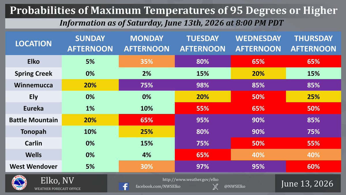


ALT The image depicts probabilities of maximum temperatures of 95 degrees or higher for select locations in Northern and Central Nevada from Sunday, June 14th, 2026 through Thursday, June 18th, 2026.
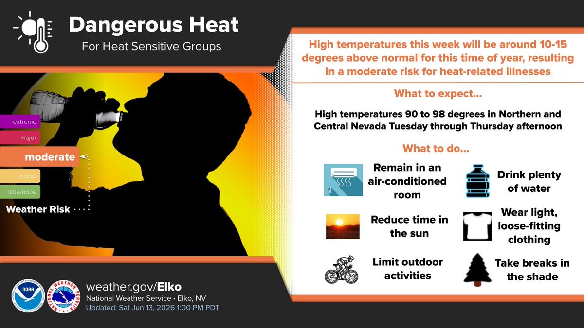
ALT The image depicts a moderate risk for heat-related illnesses in the valleys of Northern and Central Nevada Tuesday afternoon.
ALT The image depicts high temperatures throughout Northern and Central Nevada near 90 degrees Sunday afternoon. The image also indicates maximum temperatures across Northern and Central Nevada in the lower 90s Monday afternoon.
ALT High temperatures throughout Northern and Central Nevada Tuesday through Thursday will create moderate Heat Risk for those sensitive to warm temperatures and heat-related illnesses. Avoid long outdoor exposure especially in the afternoon. Those that work outside should take extra precaution to avoid heat related health issues.
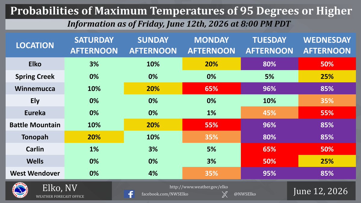
ALT The image depicts probabilities of maximum temperatures of 95 degrees or higher for select locations in Northern and Central Nevada from Saturday, June 13th, 2026 through Wednesday, June 17th, 2026.
ALT The image depicts what to do to avoid heat-related illnesses.
ALT The image depicts high temperatures throughout Northern and Central Nevada near 90 degrees both Saturday afternoon and Sunday afternoon.
ALT Confidence is increasing that a high pressure system will be building over northern and central Nevada next week. This has the potential to bring high temperatures in the mid to upper 90s across the area. Now is the time to prepare for this level of heat, especially if you or someone you know has a heat sensitivity or are vulnerable to heat. Please stay safe next week!
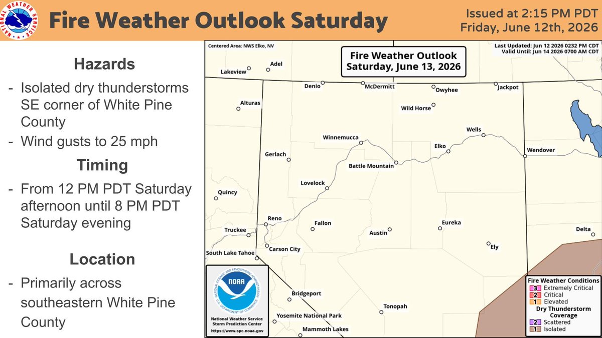
ALT A low probability (five to ten percent chance) of isolated dry thunderstorms are expected in far southeastern White Pine county Saturday afternoon. Some localized gusts to 25 mph can also be expected.
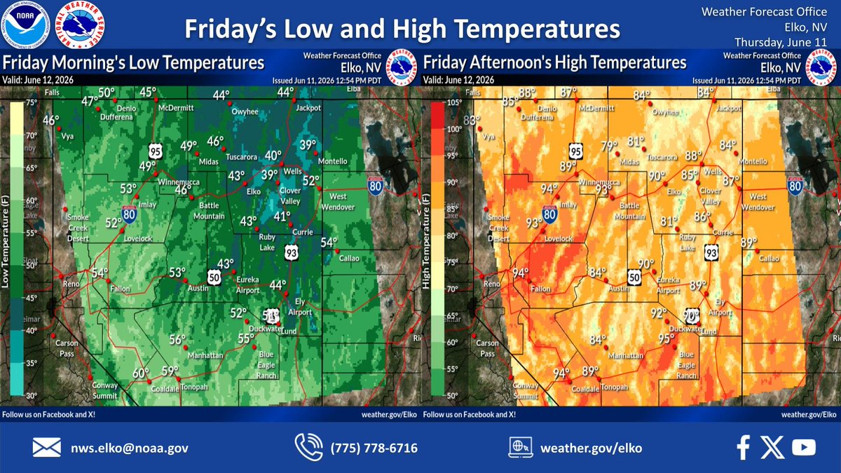
ALT Skies continue to be mostly clear tonight with overnight low temperatures in the 30s and 40s. By Friday afternoon, skies will remain mainly sunny with highs climbing into the 80s and low 90s.
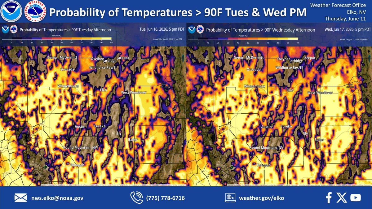
ALT Warm temperatures are expected next week across northern and central Nevada. Shown in the image are the probability of temperatures greater than 90F for Tuesday afternoon and Wednesday afternoon. There is a slight increase in the seventy percent and higher coverage of temperatures greater than 90F for Wednesday as highs warm into the mid to upper 90s in the valleys.
ALT A high pressure system will try to move east and build over northern and central Nevada during the weekend. This will bring gradually warming temperatures through the 7-day period. Highs will warm into the 80s and 90s on Friday, increasing to the 90s by early next week!
ALT Confidence is increasing that a high pressure system will be building over northern and central Nevada next week. This has the potential to bring high temperatures in the mid to upper 90s across the area. Now is the time to prepare for this level of heat, especially if you or someone you know has a heat sensitivity or are vulnerable to heat. Please stay safe next week!
ALT Clear skies tonight will lead to cooling across portions of northeastern Nevada. As a result, a frost advisory has been issued for northern and south-central Elko county from 11PM tonight to 8AM Thursday. The probability of seeing low temperatures below 36F is highest over these two sections of Elko county. Please cover temperature-sensitive plants or bring them inside to protect them from the cold.
ALT Elevated fire weather conditions will be felt today across portions of eastern Nevada this afternoon. Wind gusts up to 30 mph will combine with relative humidity values of 10 to 15%. Some localized gusts to 35 mph can also be expected.
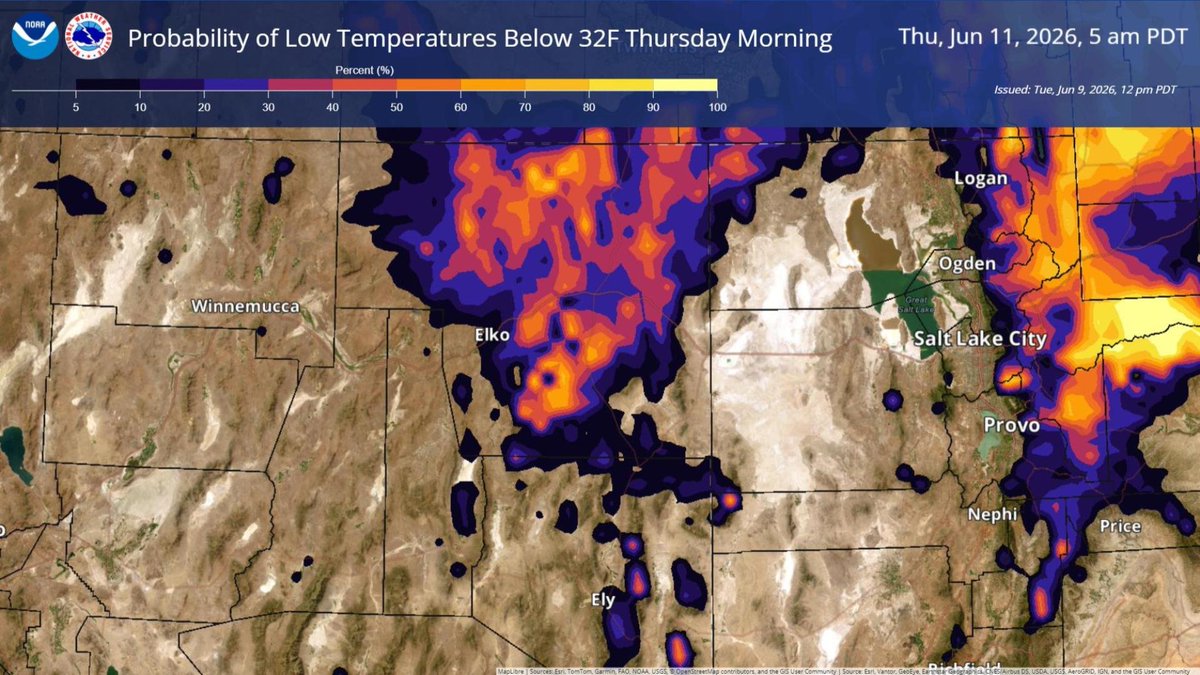
ALT A cold morning is in store across portions of northeast and eastern Nevada Thursday morning. With relatively clear skies and light winds, overnight low temperatures may drop below freezing. Shown in the image is the probability of low temperatures below 32F showing the highest percentages across Elko county. Please protect sensitive vegetation by covering or bringing them inside.
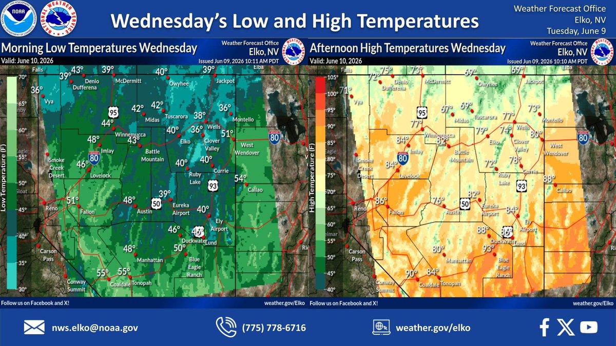
ALT Skies will be mostly clear tonight with mainly sunny skies expected Wednesday afternoon. Overnight low temperatures will range in the 30s and 40s. By tomorrow, highs will warm into the 70s and 80s.
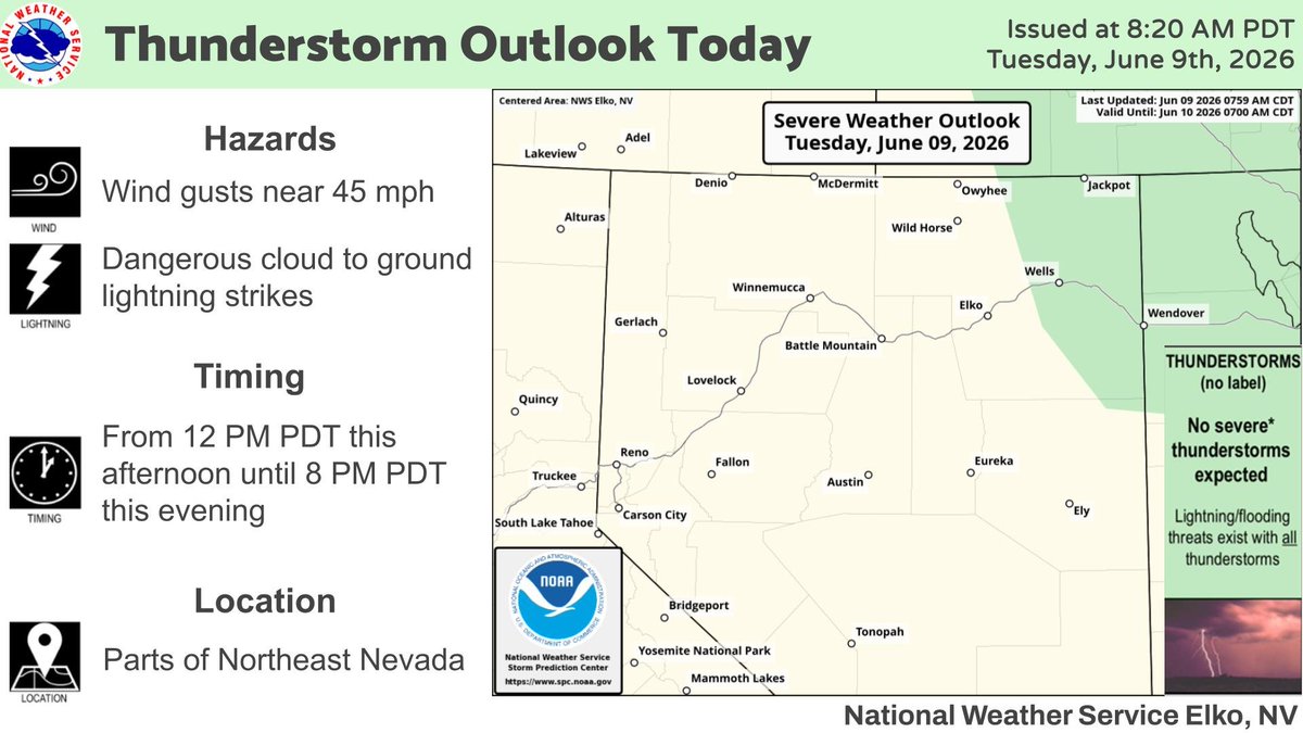
ALT Isolated thunderstorms are expected in parts of Northeastern Nevada from 12 PM PDT this afternoon until 8 PM PST this evening. A few of these thunderstorms could be strong. The primary thunderstorm hazards will be wind gusts near 45 mph and dangerous cloud to ground lightning strikes.
ALT A weak storm system will be passing through northern and central Nevada tonight into Tuesday, bringing chances for light precipitation to parts of northern Nevada. Overnight low temperatures will range in the 40s. By tomorrow, highs will warm into the 70s and 80s.

ALT The image depicts a Red Flag Warning for Eastern and Central Nevada from 11 AM PDT Monday morning until 11 PM PDT Monday evening.