
Official X Account for National Weather Service Greenville-Spartanburg, SC. Details: weather.gov/nws_x.
- Tweets 53,391
- Following 461
- Followers 36,606
- Likes 16,402
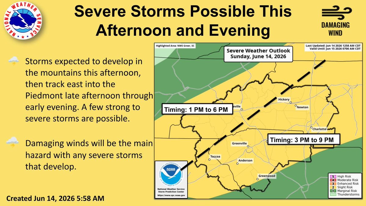


ALT Graphic showing the severe risk today across the western Carolinas and northeast Georgia. A slight risk is in place across much of the area. Damaging winds will be the main hazard with any severe storms that develop. Timing is 1 PM to 6 PM in the mountains and 3 PM to 9 PM in the Piedmont.
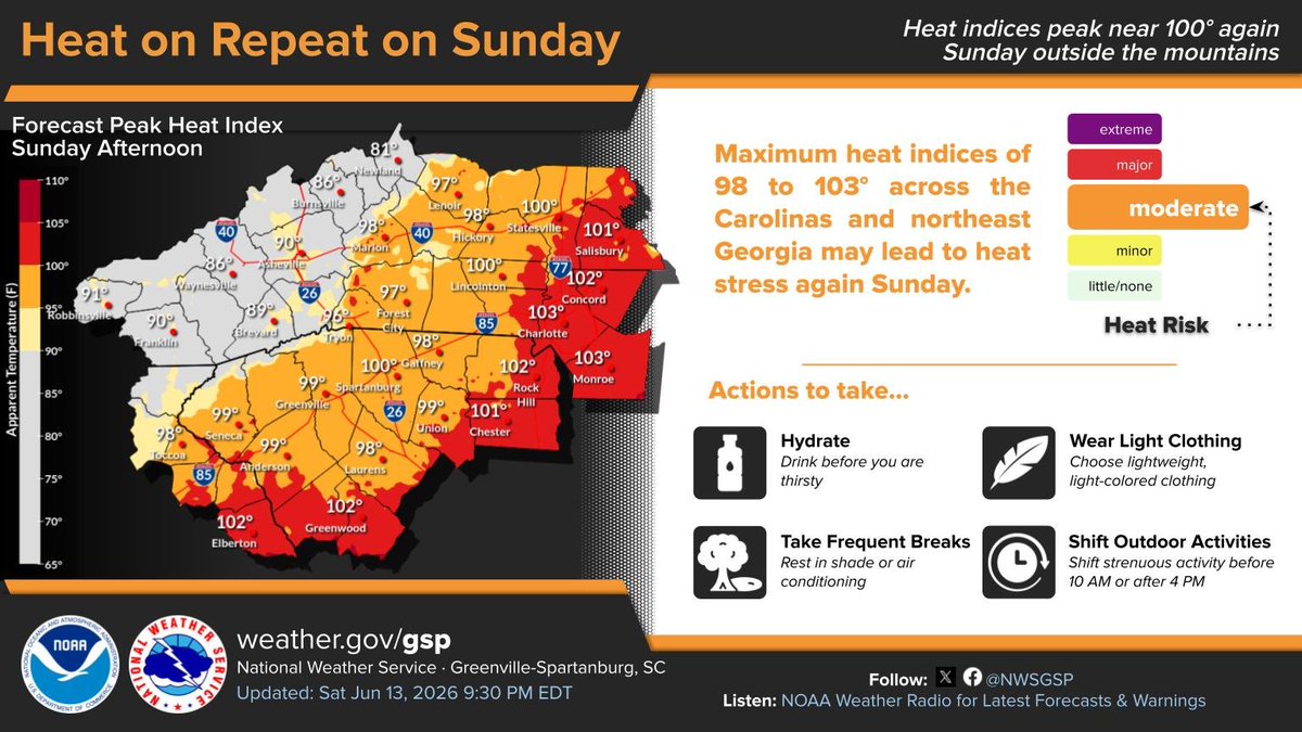
ALT Forecast heat index map for Sunday afternoon from the National Weather Service Greenville-Spartanburg. Heat indices are forecast to peak near 100 degrees again outside the mountains, with maximum values of 98 to 103 degrees across parts of the Carolinas and northeast Georgia. Cooler heat index values are shown in the mountains. Safety actions listed include hydrating, taking frequent breaks in shade or air conditioning, wearing light-colored clothing, and shifting strenuous activity before 10 AM or after 4 PM.
ALT This graphic displays a special weather statement plotted on a map. The statement is in effect until 8:00 PM EDT. The statement includes Pickens SC, Arial SC and Six Mile SC. A STRONG THUNDERSTORM WILL IMPACT NORTHERN PICKENS COUNTY THROUGH 800 PM EDT. The threats associated with this storm are wind gusts up to 40 MPH and pea sized hail. Seek shelter in a sturdy structure until the storm passes.
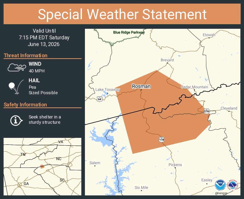
ALT This graphic displays a special weather statement plotted on a map. The statement is in effect until 7:15 PM EDT. The statement includes Rosman NC. The threats associated with this storm are wind gusts up to 40 MPH and pea sized hail. Seek shelter in a sturdy structure until the storm passes.
ALT This graphic displays a special weather statement plotted on a map. The statement is in effect until 6:30 PM EDT. The statement includes Brevard NC, Rosman NC and Cedar Mountain NC. The threats associated with this storm are wind gusts up to 40 MPH and pea sized hail. Seek shelter in a sturdy structure until the storm passes.
ALT This graphic displays a special weather statement plotted on a map. The statement is in effect until 5:45 PM EDT. The statement includes Brevard NC, Rosman NC and Cedar Mountain NC. The threats associated with this storm are wind gusts up to 40 MPH and half inch sized hail. Seek shelter in a sturdy structure until the storm passes.
ALT This graphic displays a special weather statement plotted on a map. The statement is in effect until 5:00 PM EDT. The statement includes Etowah NC, Tuxedo NC and Cedar Mountain NC. The threats associated with this storm are wind gusts up to 40 MPH and half inch sized hail. Seek shelter in a sturdy structure until the storm passes.
ALT Graphic showing the severe risk on Sunday across the western Carolinas and northeast Georgia. A slight risk is in place across much of the area. Damaging winds will be the main hazard with any severe storms that develop. Timing is 2 PM to 9 PM Sunday.
ALT Graphic showing the severe risk on Sunday across the western Carolinas and northeast Georgia. A marginal risk is in place across much of the area. Damaging winds will be the main hazard with any severe storms that develop. Timing is 2 PM to 10 PM Sunday.
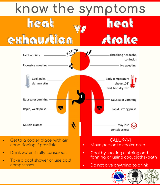
ALT Heat Exhaustion vs Heat Stroke. Symptoms of heat exhaustion include dizziness, thirst, heavy sweating, nausea, and weakness. Act fast by moving to a cooler area, loosening clothing, sipping cool water. Seek medical help if symptoms don't improve. Heat exhaustion can lead to heat stroke. Symptoms of heat stroke include confusion, dizziness, and becoming unconscious. Act fast by calling 911, moving the person to a cooler area, loosening clothing and removing extra layers, and cooling with water or ice. Heat stroke can cause death or permanent disability if emergency treatment is not given.
ALT Hot and Humid Weather Continues. Map shows today's forecast highs, mainly in the 80s in the mountains and 90s in the Piedmont. Temperatures similar to yesterday. Humid conditions expected as well with Heat Index values in the upper 90s to 104 outside of the mountains. Late afternoon and early evening isolated to widely scattered showers and storms mainly in the mountains.
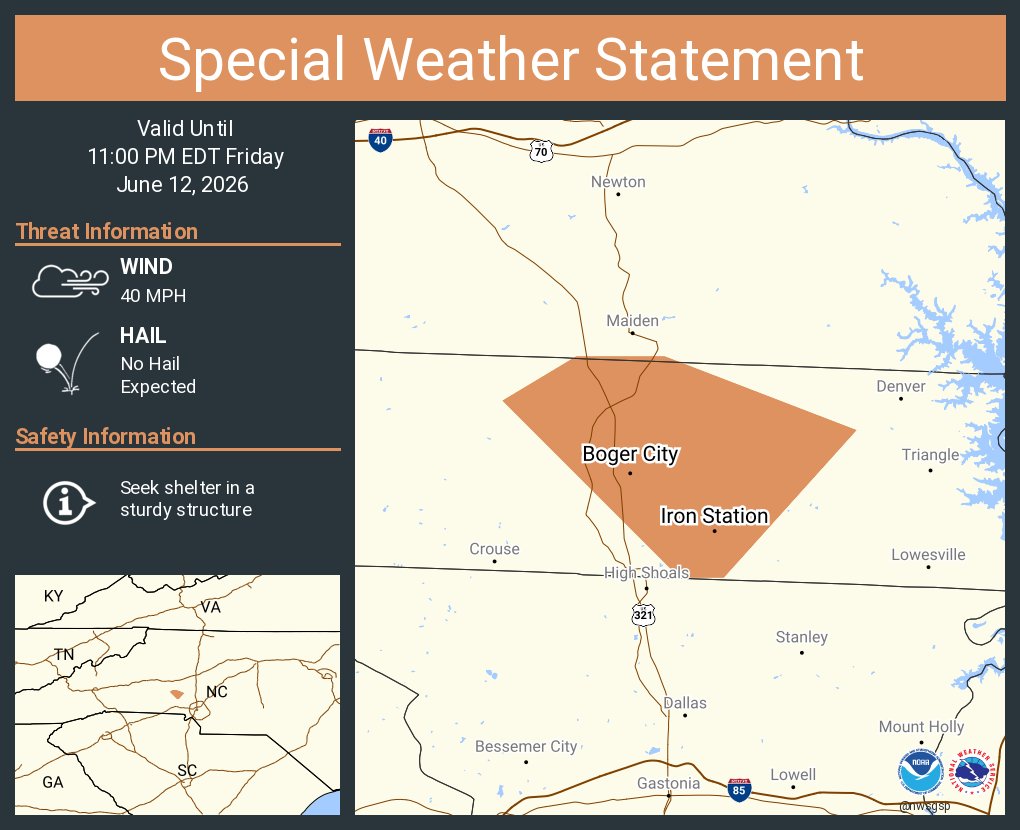
ALT This graphic displays a special weather statement plotted on a map. The statement is in effect until 11:00 PM EDT. The statement includes Iron Station NC and Boger City NC. A STRONG THUNDERSTORM WILL IMPACT CENTRAL LINCOLN COUNTY THROUGH 1100 PM EDT. The threats associated with this storm are wind gusts up to 40 MPH and no hail is expected. Seek shelter in a sturdy structure until the storm passes.
ALT This graphic displays a special weather statement plotted on a map. The statement is in effect until 9:30 PM EDT. The statement includes Greer SC, Lyman SC and Duncan SC. A STRONG THUNDERSTORM WILL IMPACT EAST CENTRAL GREENVILLE AND WEST CENTRAL SPARTANBURG COUNTIES THROUGH 930 PM EDT. The threats associated with this storm are wind gusts up to 50 MPH and half inch sized hail. Seek shelter in a sturdy structure until the storm passes.
ALT This graphic displays a severe thunderstorm warning plotted on a map. The warning is in effect until 9:30 PM EDT. The warning includes Greer SC, Taylors SC and Berea SC. This warning is for South central Henderson County in western North Carolina, Northern Greenville County in Upstate South Carolina and Northeastern Pickens County in Upstate South Carolina. The threats associated with this warning are wind gusts up to 60 MPH and half dollar sized hail. There are 136,869 people in the warning along with 29 schools and 3 hospitals.

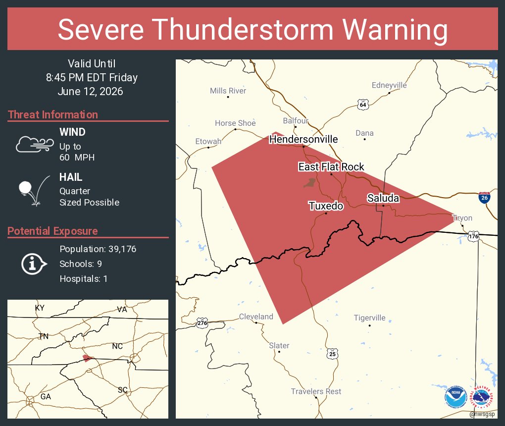
ALT This graphic displays a severe thunderstorm warning plotted on a map. The warning is in effect until 8:45 PM EDT. The warning includes Saluda NC and Tuxedo NC. This warning is for Southeastern Henderson, Southwestern Polk and North Central Greenville Counties. The threats associated with this warning are wind gusts up to 60 MPH and quarter sized hail. There are 9,051 people in the warning along with 0 schools and 0 hospitals.
ALT This graphic displays a severe thunderstorm warning plotted on a map. The warning is in effect until 8:45 PM EDT. The warning includes Hendersonville NC, East Flat Rock NC and Flat Rock NC. This warning is for Southeastern Henderson County in western North Carolina, Southwestern Polk County in western North Carolina and North central Greenville County in Upstate South Carolina. The threats associated with this warning are wind gusts up to 60 MPH and quarter sized hail. There are 39,176 people in the warning along with 9 schools and 1 hospital.
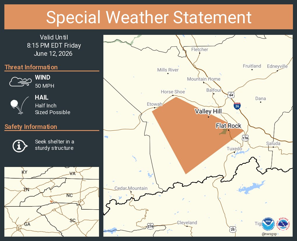
ALT This graphic displays a special weather statement plotted on a map. The statement is in effect until 8:15 PM EDT. The statement includes Flat Rock NC and Valley Hill NC. A STRONG THUNDERSTORM WILL IMPACT SOUTH CENTRAL HENDERSON COUNTY THROUGH 815 PM EDT. The threats associated with this storm are wind gusts up to 50 MPH and half inch sized hail. Seek shelter in a sturdy structure until the storm passes.
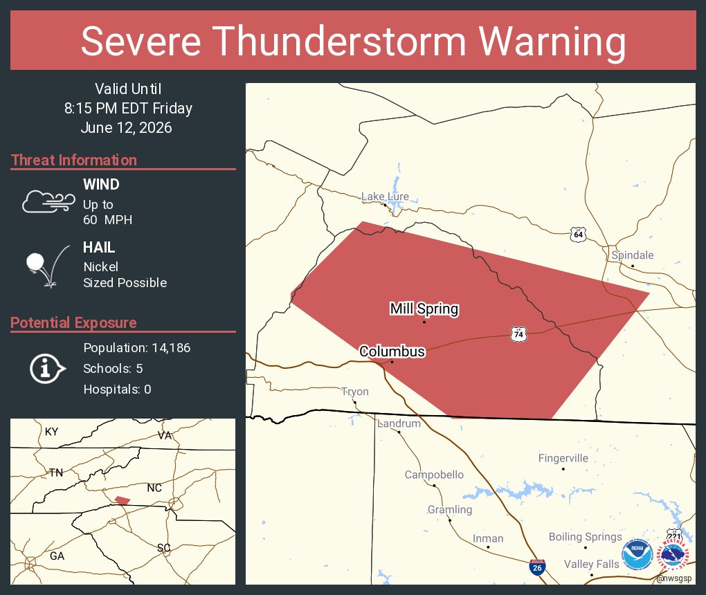
ALT This graphic displays a severe thunderstorm warning plotted on a map. The warning is in effect until 8:15 PM EDT. The warning includes Columbus NC and Mill Spring NC. This warning is for East Central Henderson County Is Cancelled. The threats associated with this warning are wind gusts up to 60 MPH and nickel sized hail. There are 14,186 people in the warning along with 5 schools and 0 hospitals.