
Official Twitter Account for National Weather Service Wilmington OH. Details: weather.gov/twitter
- Tweets 27,283
- Following 94
- Followers 54,737
- Likes 3,003


ALT Left table shows hourly probability of precipitation by location. The right graphic shows peak wind gusts for today.

ALT Left graphic shows high temperatures forecast for Saturday. The right graphic shows the high temperatures forecast for Sunday.
ALT Picture of patchy dense fog.
ALT Graphs showing temperatures and precipitation chances into next week.

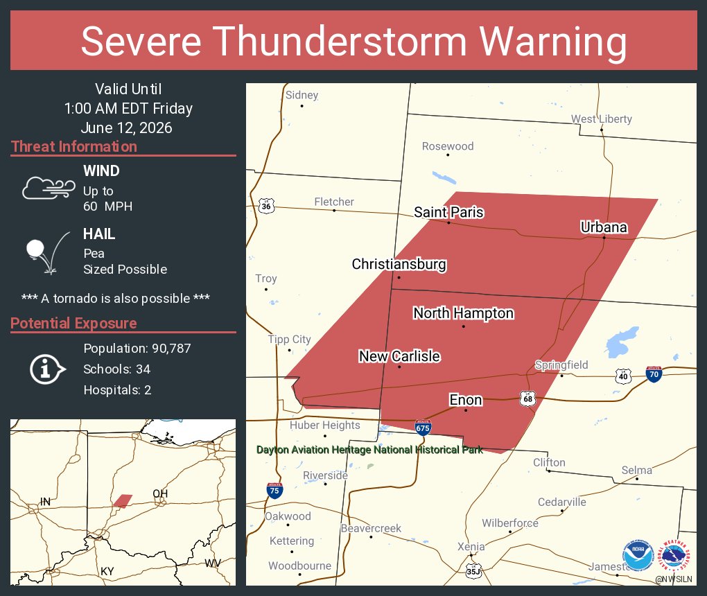
ALT This graphic displays a severe thunderstorm warning plotted on a map. The warning is in effect until 1:00 AM EDT. The warning includes Urbana OH, New Carlisle OH and Enon OH. This warning is for Southwestern Champaign County in west central Ohio, Western Clark County in west central Ohio and Southeastern Miami County in west central Ohio. The threats associated with this warning are wind gusts up to 60 MPH and pea sized hail. There are 90,787 people in the warning along with 34 schools and 2 hospitals.
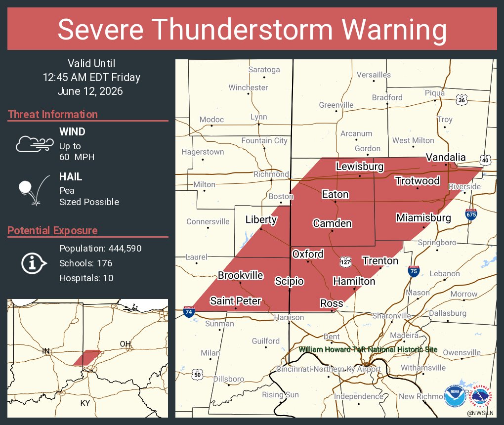
ALT This graphic displays a severe thunderstorm warning plotted on a map. The warning is in effect until 12:45 AM EDT. The warning includes Hamilton OH, Huber Heights OH and Trotwood OH. This warning is for Franklin County in southeastern Indiana, Union County in east central Indiana, Preble County in west central Ohio, Butler County in southwestern Ohio and Montgomery County in west central Ohio. The threats associated with this warning are wind gusts up to 60 MPH and pea sized hail. There are 444,590 people in the warning along with 176 schools and 10 hospitals.
ALT This graphic displays a severe thunderstorm warning plotted on a map. The warning is in effect until 12:45 AM EDT. The warning includes Troy OH, Sidney OH and Piqua OH. This warning is for Shelby County in west central Ohio, Northwestern Champaign County in west central Ohio, Logan County in west central Ohio, Southeastern Darke County in west central Ohio, Hardin County in west central Ohio, Auglaize County in west central Ohio and Miami County in west central Ohio. The threats associated with this warning are wind gusts up to 60 MPH and pea sized hail. There are 227,321 people in the warning along with 96 schools and 4 hospitals.
ALT This graphic displays a tornado warning plotted on a map. The warning is in effect until 11:45 PM EDT. The warning includes Rockford OH, Mendon OH and Neptune OH. This warning is for Northern Mercer County in west central Ohio. The threats associated with this warning are a radar indicated tornado and no hail is expected. There are 4,946 people in the warning along with 2 schools and 0 hospitals.
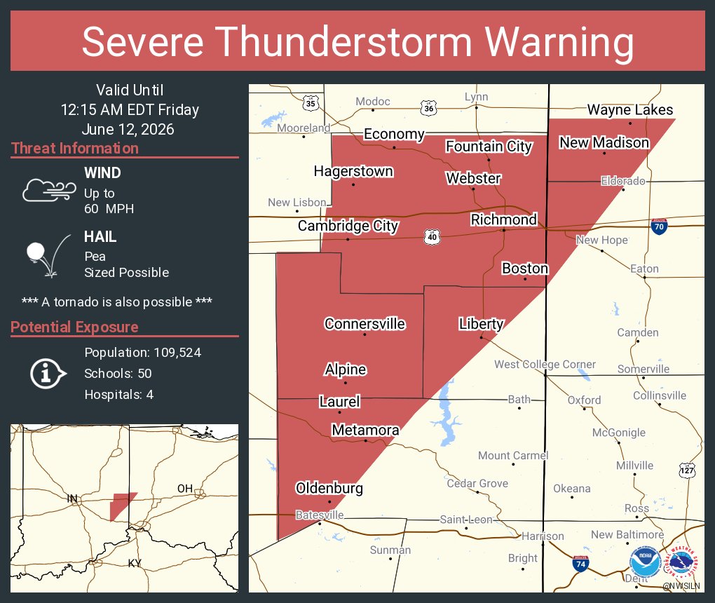
ALT This graphic displays a severe thunderstorm warning plotted on a map. The warning is in effect until 12:15 AM EDT. The warning includes Richmond IN, Connersville IN and Centerville IN. This warning is for Western Franklin County in southeastern Indiana, Wayne County in east central Indiana, Northwestern Union County in east central Indiana, Fayette County in east central Indiana, Northwestern Preble County in west central Ohio and Southwestern Darke County in west central Ohio. The threats associated with this warning are wind gusts up to 60 MPH and pea sized hail. There are 109,524 people in the warning along with 50 schools and 4 hospitals.
ALT This graphic displays a severe thunderstorm warning plotted on a map. The warning is in effect until 12:00 AM EDT. The warning includes Greenville OH, Celina OH and Saint Marys OH. This warning is for Western Shelby County in west central Ohio, Darke County in west central Ohio, Western Auglaize County in west central Ohio and Mercer County in west central Ohio. The threats associated with this warning are wind gusts up to 60 MPH and pea sized hail. There are 111,234 people in the warning along with 50 schools and 3 hospitals.
ALT Graphic showing the outline of severe thunderstorm watch #319.
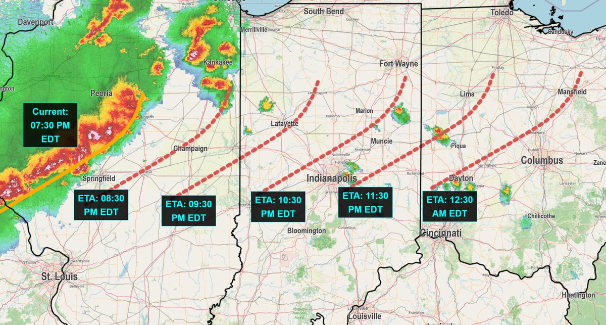
ALT Graphic shows a radar map with projected estimated arrival times of a line of storms through Illinois, Indiana, and Ohio.
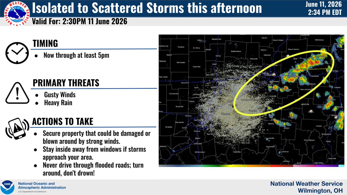
ALT Graphic showing storms forming along and near I-71 by the Columbus metro this afternoon.
ALT This graphic displays a severe thunderstorm warning plotted on a map. The warning is in effect until 2:45 PM EDT. The warning includes Hanover OH and Marne OH. This warning is for East central Licking County in central Ohio. The threats associated with this warning are wind gusts up to 60 MPH and pea sized hail. There are 5,356 people in the warning along with 2 schools and 0 hospitals.
ALT Maps showing the severe weather outlook for today.
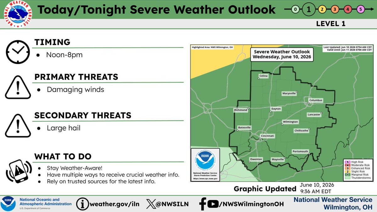
ALT Map showing the severe weather outlook for today. A marginal risk across the entire area.