
Official Twitter account for the National Weather Service Jackson, Mississippi. Details: weather.gov/nws_x
- Tweets 60,852
- Following 533
- Followers 47,663
- Likes 12,545


ALT This graphic displays a special weather statement plotted on a map. The statement is in effect until 11:15 PM CDT. The statement includes Caledonia MS and Kolola Springs MS. A STRONG THUNDERSTORM WILL IMPACT NORTHEASTERN LOWNDES COUNTY THROUGH 1115 PM CDT. The threats associated with this storm are wind gusts up to 40 MPH and no hail is expected. Seek shelter in a sturdy structure until the storm passes.
ALT This graphic displays a special weather statement plotted on a map. The statement is in effect until 5:15 PM CDT. The statement includes Columbus MS, New Hope MS and Artesia MS. A STRONG THUNDERSTORM WILL IMPACT SOUTHEASTERN CLAY AND LOWNDES COUNTIES THROUGH 515 PM CDT. The threats associated with this storm are wind gusts up to 40 MPH and no hail is expected. Seek shelter in a sturdy structure until the storm passes.
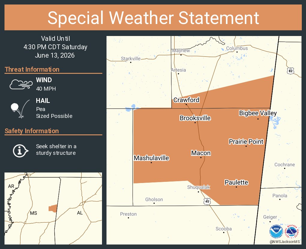
ALT This graphic displays a special weather statement plotted on a map. The statement is in effect until 4:30 PM CDT. The statement includes Macon MS, Brooksville MS and Crawford MS. A STRONG THUNDERSTORM WILL IMPACT NOXUBEE AND SOUTHERN LOWNDES COUNTIES THROUGH 430 PM CDT. The threats associated with this storm are wind gusts up to 40 MPH and pea sized hail. Seek shelter in a sturdy structure until the storm passes.
ALT This graphic displays a special weather statement plotted on a map. The statement is in effect until 2:45 PM CDT. The statement includes Collinsville MS, Nellieburg MS and Chunky MS. A STRONG THUNDERSTORM WILL IMPACT NORTHEASTERN NEWTON AND NORTHWESTERN LAUDERDALE COUNTIES THROUGH 245 PM CDT. The threats associated with this storm are wind gusts up to 40 MPH and no hail is expected. Seek shelter in a sturdy structure until the storm passes.

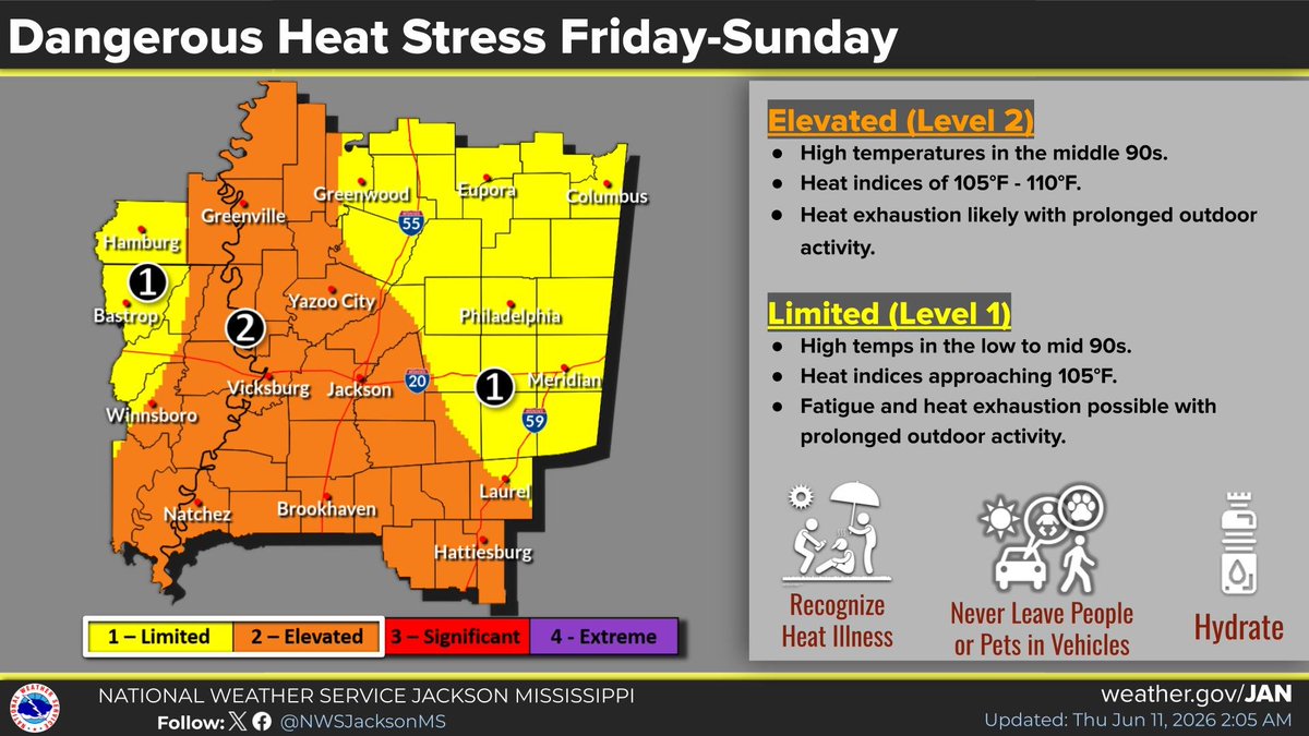
ALT Much of the area will experience heat indices from near 105 F up to 110 F during the afternoons and early evenings through Sunday. Heat exhaustion is possible with prolonged outdoor activities.
ALT A frontal boundary will bring rain and thunderstorms capable of producing heavy rainfall. Flash flooding will be possible.
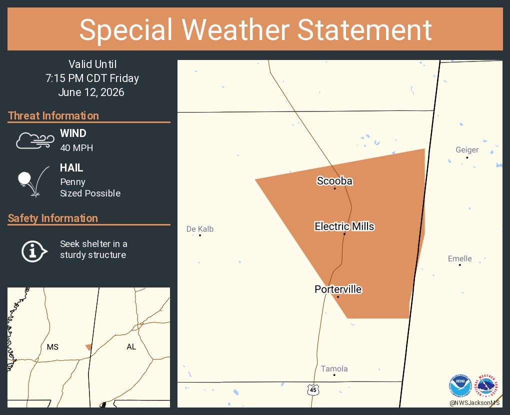
ALT This graphic displays a special weather statement plotted on a map. The statement is in effect until 7:15 PM CDT. The statement includes Scooba MS, Electric Mills MS and Porterville MS. A STRONG THUNDERSTORM WILL IMPACT NORTHEASTERN KEMPER COUNTY THROUGH 715 PM CDT. The threats associated with this storm are wind gusts up to 40 MPH and penny sized hail. Seek shelter in a sturdy structure until the storm passes.
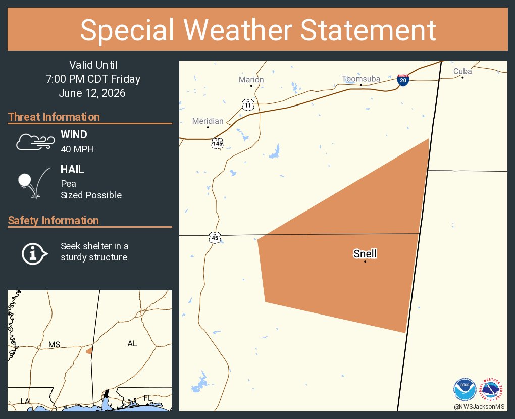
ALT This graphic displays a special weather statement plotted on a map. The statement is in effect until 7:00 PM CDT. The statement includes Snell MS. A STRONG THUNDERSTORM WILL IMPACT NORTHEASTERN CLARKE AND SOUTHEASTERN LAUDERDALE COUNTIES THROUGH 700 PM CDT. The threats associated with this storm are wind gusts up to 40 MPH and pea sized hail. Seek shelter in a sturdy structure until the storm passes.
ALT Much of the area will experience heat indices from near 105 F up to 110 F during the afternoons and early evenings Today through Sunday. Heat exhaustion is possible with prolonged outdoor activities.
ALT A frontal boundary will bring rain and thunderstorms capable of producing heavy rainfall. Flash flooding will be possible.
ALT Quiet evening under partly cloudy skies. An isolated shower is possible in the Delta region near daybreak.
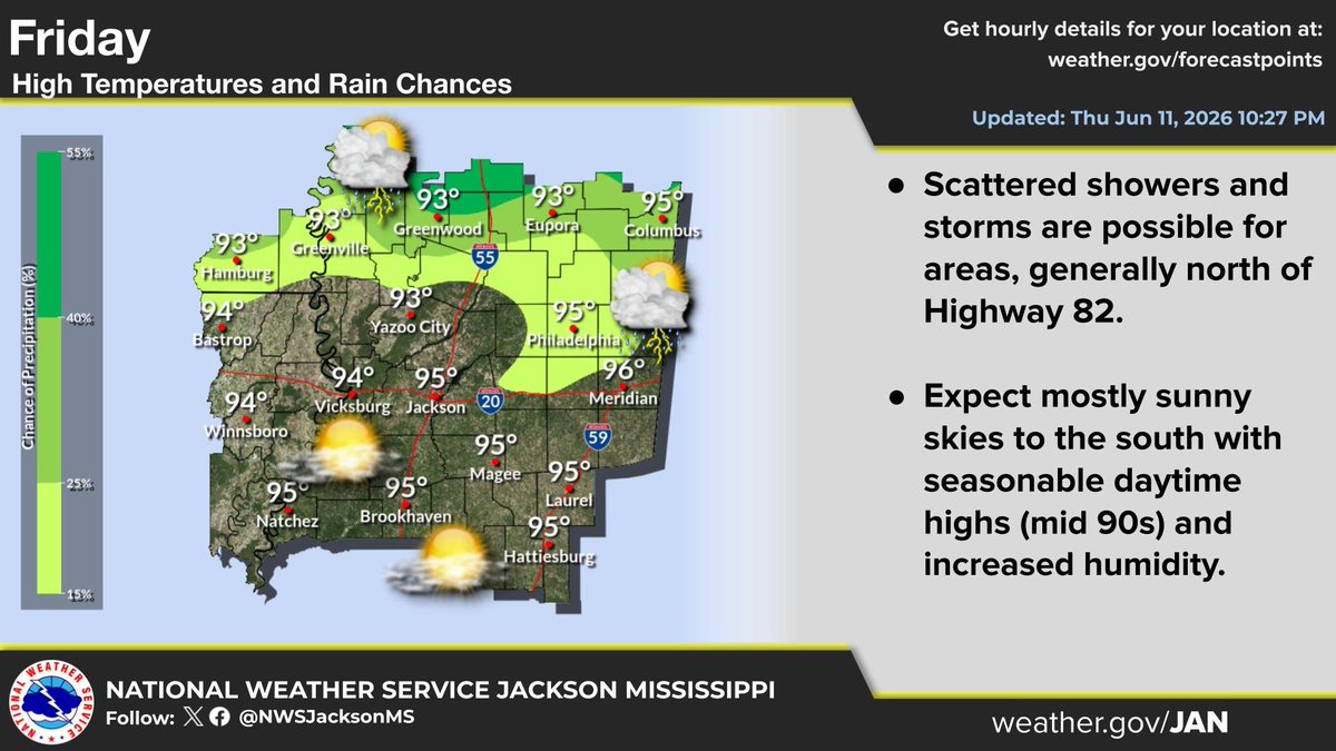
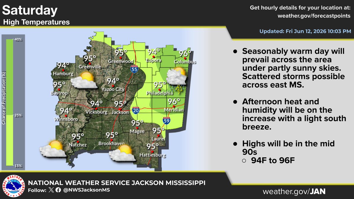
ALT Seasonably warm and humid Friday under sunny skies. Scattered storms will be possible north of Hwy 82. Highs in the mid 90s.
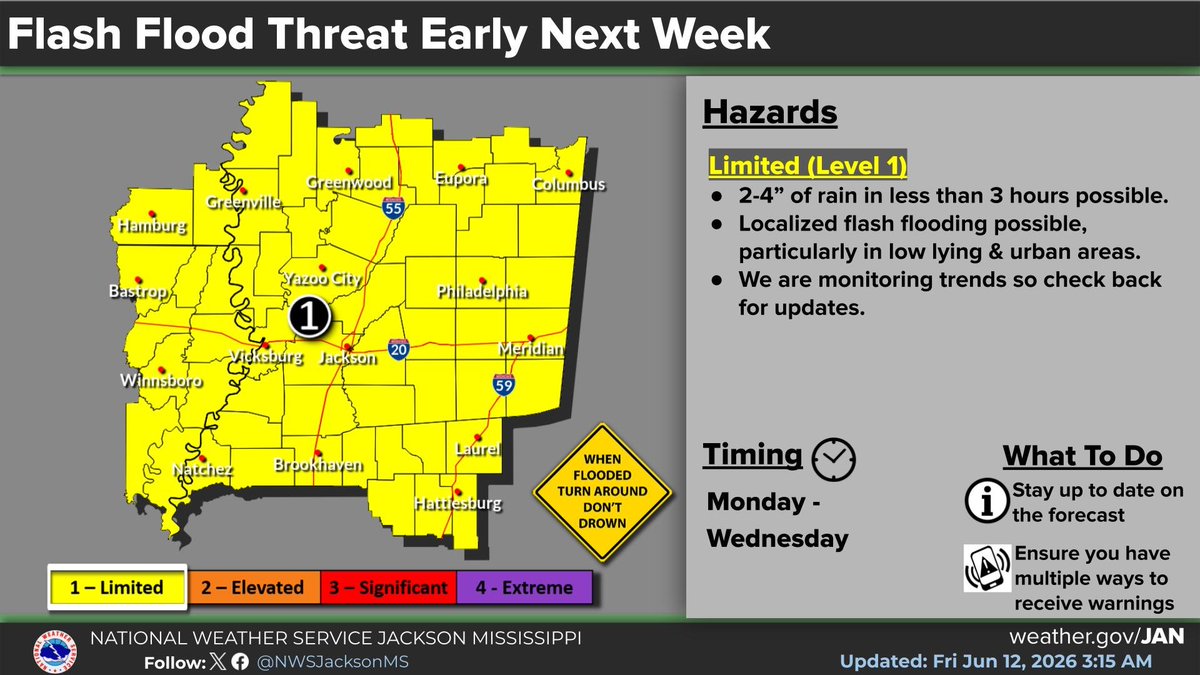
ALT Dangerous heat this weekend will be followed by a period of heavy rainfall that could lead to flash flooding early next week. The area of heaviest rainfall is still uncertain, so continue to check back for updates.

ALT Dangerous heat this weekend will be followed by a period of heavy rainfall that could lead to flash flooding early next week. The area of heaviest rainfall is still uncertain, so continue to check back for updates.
ALT A frontal boundary will bring rain and thunderstorms capable of produced heavy rainfall. Flash flooding will be possible. Expect future updates.
ALT Much of the area will experience heat indices from near 105 F up to 110 F during the afternoons and early evenings Friday through Sunday. Heat exhaustion is possible with prolonged outdoor activities.

ALT Quiet evening is expected under clear skies. Patchy fog can't be ruled out near Highway 84, briefly near daybreak. Lows will be seasonably warm in the low to mid 70s, with the warmest in the northwest Delta region.
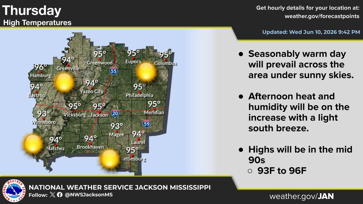
ALT Seasonably warm day is expected Thursday under sunny skies. Afternoon heat and humidity will be on the increase with a light south breeze. High temperatures will be in the mid 90s.
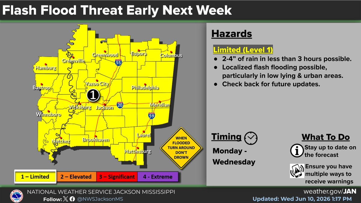
ALT A frontal boundary will bring rain and thunderstorms capable of produced heavy rainfall. Flash flooding will be possible. Expect future updates.

ALT Much of the area will experience heat indices from near 105 F up to 110 F during the afternoons and early evenings Friday through Sunday. Heat exhaustion is possible with prolonged outdoor activities.

ALT Much of the area outside of northeast Mississippi will experience heat indices near 105 F during the afternoons and early evenings Friday through Sunday. Heat exhaustion is possible with prolonged outdoor activities.