
Official Twitter account for the National Weather Service Abilene/San Angelo. Details: weather.gov/nws_x
- Tweets 23,848
- Following 250
- Followers 23,574
- Likes 2,015


ALT Graphic on the left shows the heat risk outlook, while text on the right provides additional details.

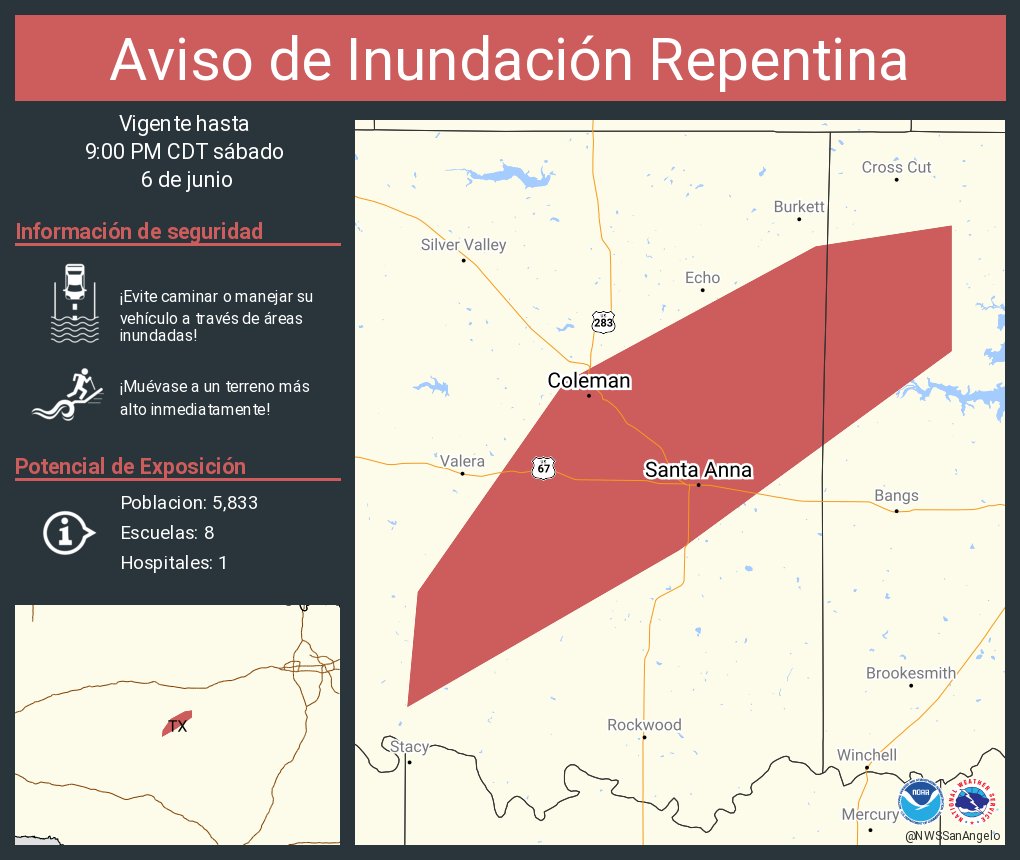
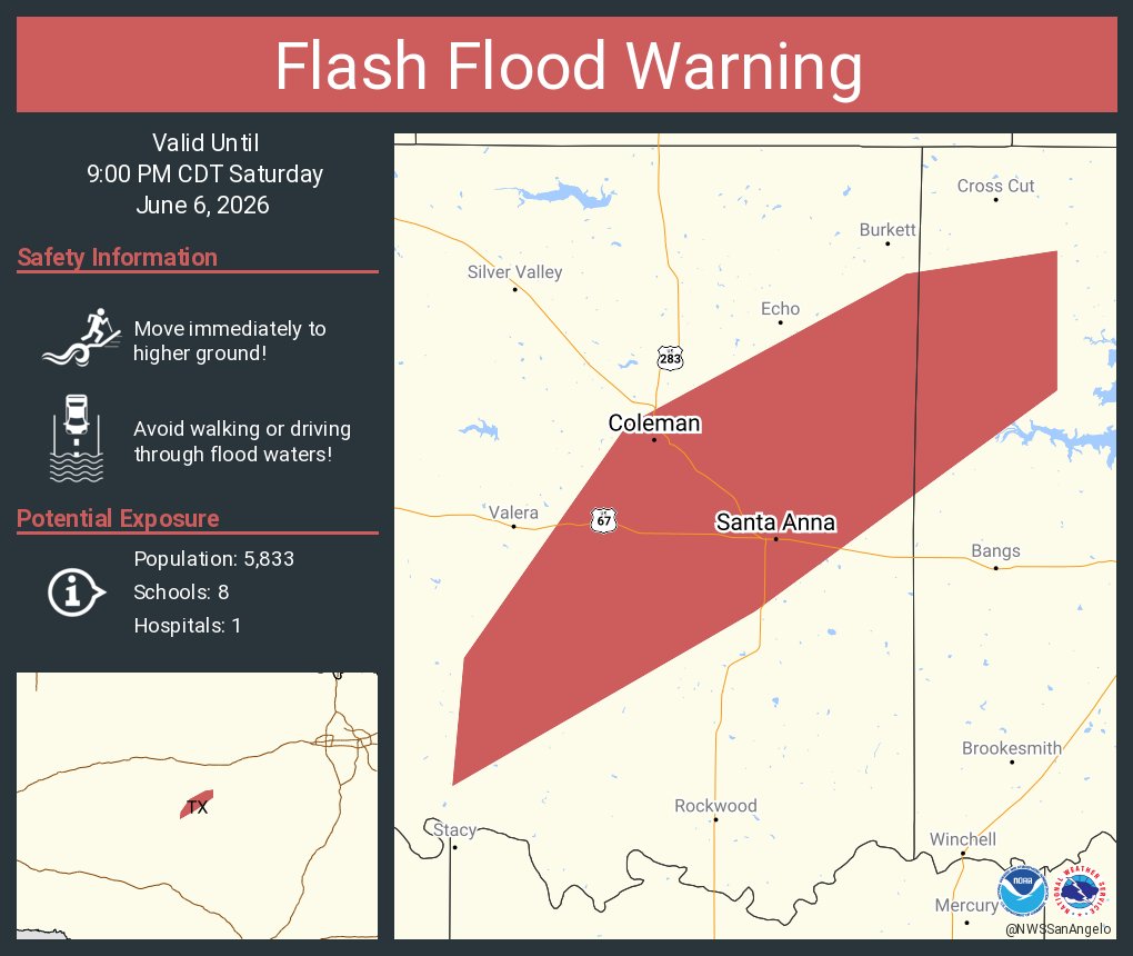
ALT Este gráfico muestra la localización en el mapa de un aviso de inundación repentina. El aviso estará en efecto hasta las 9:00 PM CDT. El aviso incluye a Coleman TX, Santa Anna TX. El aviso incluye el noroeste del condado de Brown en el oeste centro de Texas y el sureste del condado de Coleman en el oeste centro de Texas. ¡Evite caminar o manejar su vehículo a través de áreas inundadas! ¡Muévase a un terreno más alto inmediatamente! Hay 5,833 personas bajo este aviso incluyendo 8 escuelas y 1 hospital.
ALT This graphic displays a flash flood warning plotted on a map. The warning is in effect until 9:00 PM CDT. The warning includes Coleman TX and Santa Anna TX. This warning is for Northwestern Brown County in west central Texas and Southeastern Coleman County in west central Texas. Avoid walking or driving through flood waters! Move immediately to higher ground! There are 5,833 people in the warning along with 8 schools and 1 hospital.
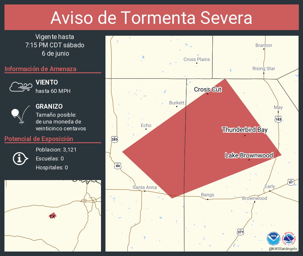
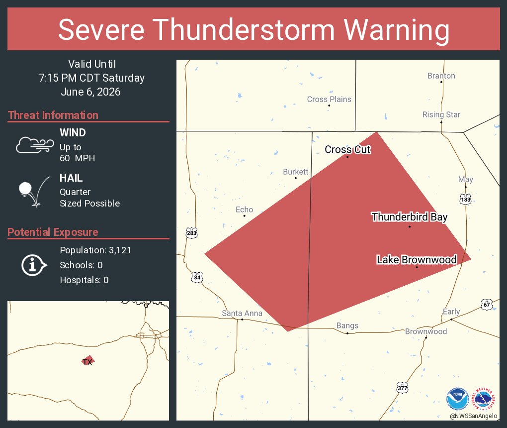
ALT Este gráfico muestra la localización en el mapa de un aviso de tormenta severa. El aviso estará en efecto hasta las 7:15 PM CDT. El aviso incluye a Lake Brownwood TX, Thunderbird Bay TX, Owens TX. El aviso incluye el noroeste del condado de Brown en el oeste centro de Texas y el condado de el este centro de Coleman en el oeste centro de Texas. Las amenazas asociadas a este aviso son: ráfagas de viento de 60 MPH y granizo del tamaño de una moneda de veinticinco centavos. Hay 3,121 personas bajo este aviso incluyendo 0 escuelas y 0 hospitales.
ALT This graphic displays a severe thunderstorm warning plotted on a map. The warning is in effect until 7:15 PM CDT. The warning includes Lake Brownwood TX, Thunderbird Bay TX and Owens TX. This warning is for Northwestern Brown County in west central Texas and East central Coleman County in west central Texas. The threats associated with this warning are wind gusts up to 60 MPH and quarter sized hail. There are 3,121 people in the warning along with 0 schools and 0 hospitals.
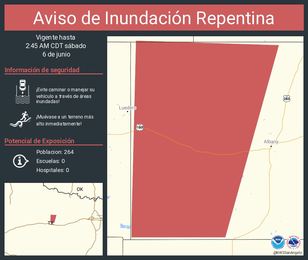
ALT Este gráfico muestra la localización en el mapa de un aviso de inundación repentina. El aviso estará en efecto hasta las 2:45 AM CDT. El aviso incluye a Shackelford County, TX. El aviso incluye el oeste del condado de Shackelford en el oeste centro de Texas. ¡Evite caminar o manejar su vehículo a través de áreas inundadas! ¡Muévase a un terreno más alto inmediatamente! Hay 264 personas bajo este aviso incluyendo 0 escuelas y 0 hospitales.
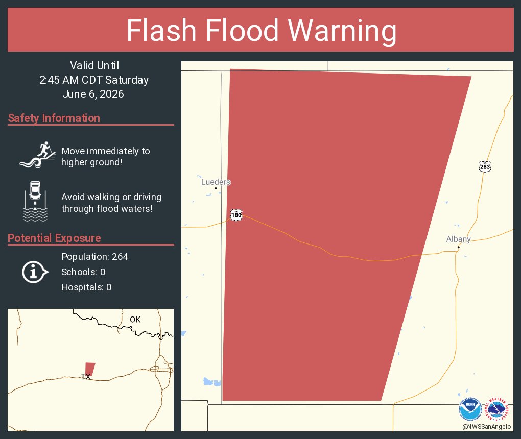
ALT This graphic displays a flash flood warning plotted on a map. The warning is in effect until 2:45 AM CDT. The warning includes Shackelford County, TX. This warning is for Western Shackelford County in west central Texas. Avoid walking or driving through flood waters! Move immediately to higher ground! There are 264 people in the warning along with 0 schools and 0 hospitals.
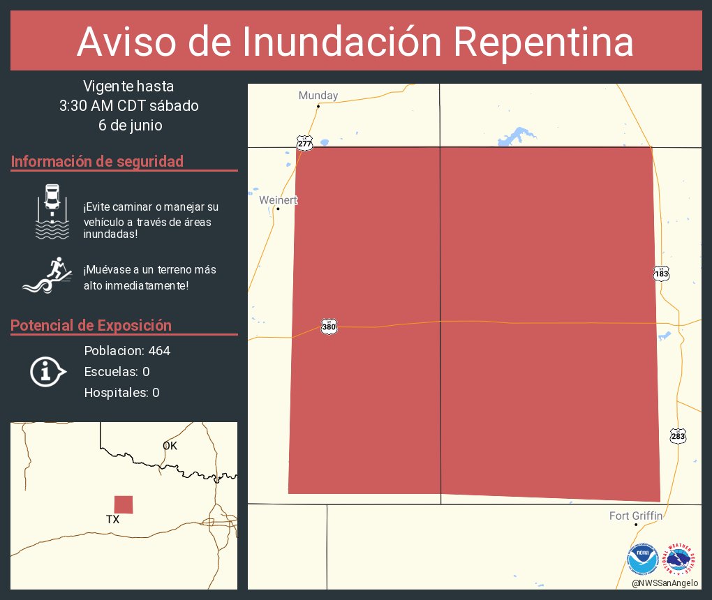
ALT Este gráfico muestra la localización en el mapa de un aviso de inundación repentina. El aviso estará en efecto hasta las 3:30 AM CDT. El aviso incluye a Throckmorton County, TX. El aviso incluye el este del condado de Haskell en el oeste centro de Texas y el oeste del condado de Throckmorton en el oeste centro de Texas. ¡Evite caminar o manejar su vehículo a través de áreas inundadas! ¡Muévase a un terreno más alto inmediatamente! Hay 464 personas bajo este aviso incluyendo 0 escuelas y 0 hospitales.

ALT This graphic displays a flash flood warning plotted on a map. The warning is in effect until 3:30 AM CDT. The warning includes Haskell County, TX, Throckmorton County, TX. This warning is for Eastern Haskell County in west central Texas and Western Throckmorton County in west central Texas. Avoid walking or driving through flood waters! Move immediately to higher ground! There are 464 people in the warning along with 0 schools and 0 hospitals.

ALT Este gráfico muestra la localización en el mapa de un aviso de inundación repentina. El aviso estará en efecto hasta las 2:00 AM CDT. El aviso incluye a Abilene TX, Potosi TX, Merkel TX. El aviso incluye el condado de Taylor en el oeste centro de Texas. ¡Evite caminar o manejar su vehículo a través de áreas inundadas! ¡Muévase a un terreno más alto inmediatamente! Hay 146,967 personas bajo este aviso incluyendo 62 escuelas y 5 hospitales.