
Official X Account for National Weather Service State College, PA. Details: weather.gov/nws_x
- Tweets 37,942
- Following 546
- Followers 26,493
- Likes 12,158


ALT Harrisburg, PA

ALT Ephrata

ALT Elizabethtown

ALT Reach Cyber Charter School, Harrisburg
ALT For those in Central or Eastern Pennsylvania, please monitor local conditions this afternoon or early evening, as localized severe storms could develop.

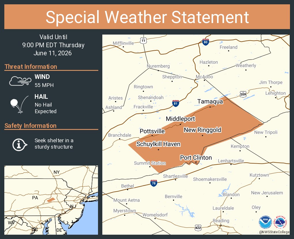
ALT This graphic displays a special weather statement plotted on a map. The statement is in effect until 9:00 PM EDT. The statement includes Pottsville PA, Tamaqua PA and Schuylkill Haven PA. A STRONG THUNDERSTORM WILL IMPACT SOUTHEASTERN SCHUYLKILL COUNTY THROUGH 900 PM EDT. The threats associated with this storm are wind gusts up to 55 MPH and no hail is expected. Seek shelter in a sturdy structure until the storm passes.
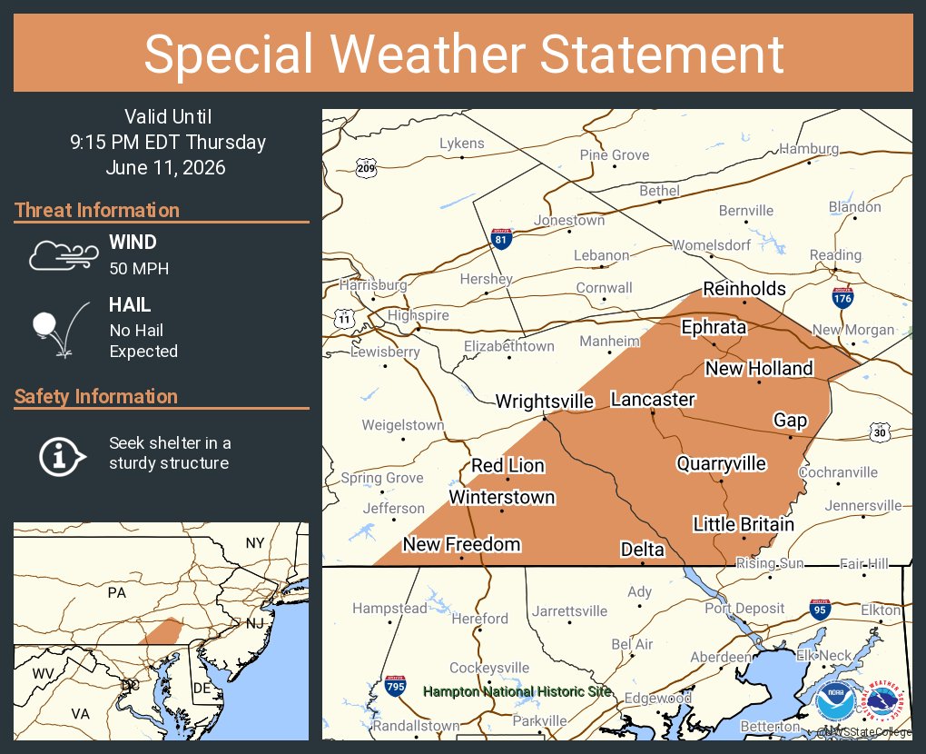
ALT This graphic displays a special weather statement plotted on a map. The statement is in effect until 9:15 PM EDT. The statement includes Lancaster PA, Ephrata PA and Columbia PA. STRONG THUNDERSTORMS WILL IMPACT LANCASTER AND SOUTHEASTERN YORK COUNTIES THROUGH 915 PM EDT. The threats associated with this storm are wind gusts up to 50 MPH and no hail is expected. Seek shelter in a sturdy structure until the storm passes.
ALT This graphic displays a flash flood warning plotted on a map. The warning is in effect until 11:15 PM EDT. The warning includes Waller PA. Avoid walking or driving through flood waters! Move immediately to higher ground! There are 4,272 people in the warning along with 1 school and 0 hospitals.
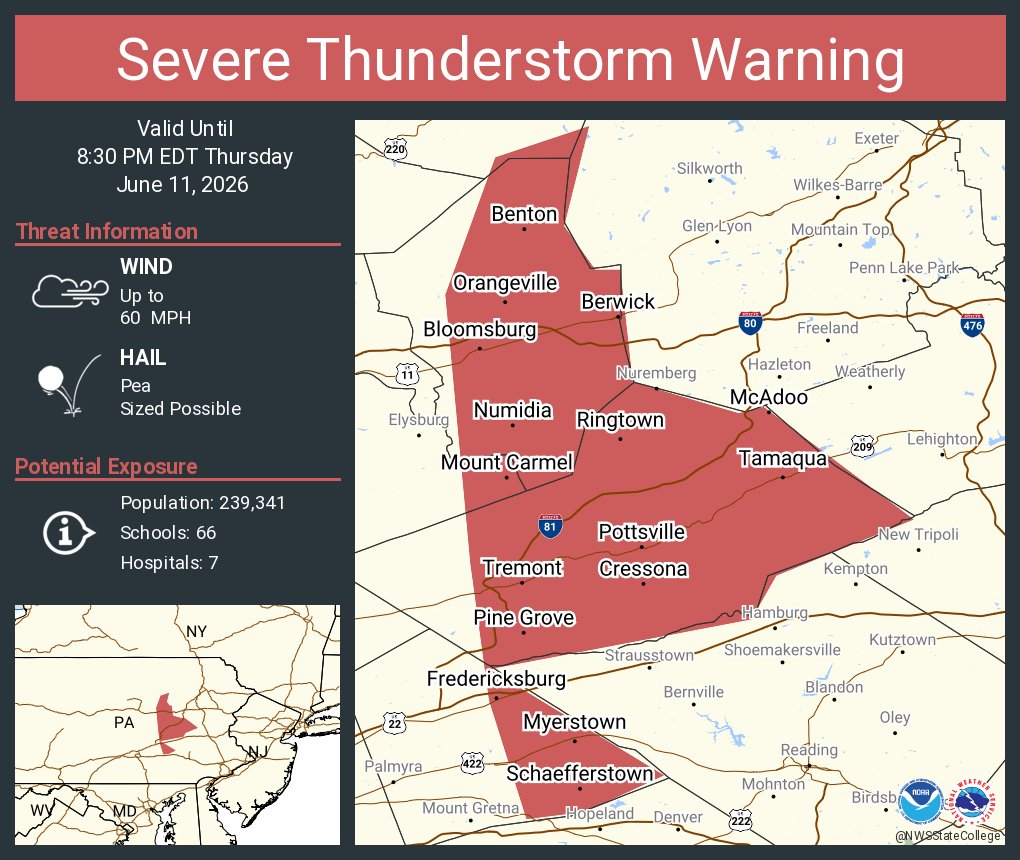
ALT This graphic displays a severe thunderstorm warning plotted on a map. The warning is in effect until 8:30 PM EDT. The warning includes Bloomsburg PA, Pottsville PA and Berwick PA. This warning is for Northeastern Dauphin, Southeastern Lycoming and Montour Counties Is Cancelled. The threats associated with this warning are wind gusts up to 60 MPH and pea sized hail. There are 239,341 people in the warning along with 66 schools and 7 hospitals.
ALT This graphic displays a flash flood warning plotted on a map. The warning is in effect until 11:15 PM EDT. The warning includes Waller PA. This warning is for Northwestern Columbia County in central Pennsylvania, Southeastern Lycoming County in north central Pennsylvania and Southeastern Sullivan County in north central Pennsylvania. Avoid walking or driving through flood waters! Move immediately to higher ground! There are 4,272 people in the warning along with 1 school and 0 hospitals.
ALT This graphic displays a special weather statement plotted on a map. The statement is in effect until 8:30 PM EDT. The statement includes York PA, Hanover PA and Weigelstown PA. A GUSTY SHOWER WILL IMPACT NORTHWESTERN LANCASTER and SOUTHEASTERN ADAMS AND WESTERN YORK COUNTIES THROUGH 830 PM EDT. The threats associated with this storm are wind gusts up to 50 MPH and no hail is expected. Seek shelter in a sturdy structure until the storm passes.
ALT This graphic displays a severe thunderstorm warning plotted on a map. The warning is in effect until 8:30 PM EDT. The warning includes Lebanon PA, Bloomsburg PA and Pottsville PA. This warning is for Columbia County in central Pennsylvania, Northeastern Dauphin County in south central Pennsylvania, Lebanon County in south central Pennsylvania, Southeastern Lycoming County in north central Pennsylvania, Montour County in central Pennsylvania, Northumberland County in central Pennsylvania, Schuylkill County in central Pennsylvania and Southeastern Sullivan County in north central Pennsylvania. The threats associated with this warning are wind gusts up to 60 MPH and pea sized hail. There are 444,463 people in the warning along with 126 schools and 16 hospitals.
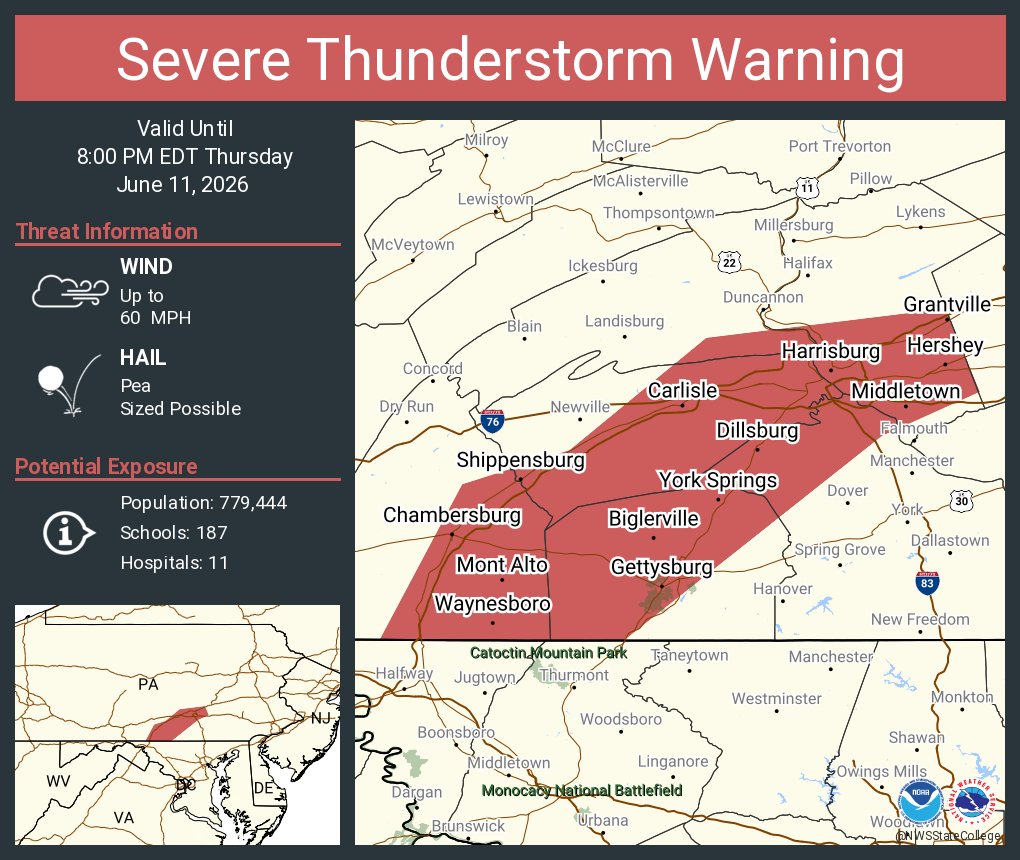
ALT This graphic displays a severe thunderstorm warning plotted on a map. The warning is in effect until 8:00 PM EDT. The warning includes Harrisburg PA, Chambersburg PA and Carlisle PA. This warning is for Adams County in south central Pennsylvania, Cumberland County in south central Pennsylvania, Southern Dauphin County in south central Pennsylvania, Southeastern Franklin County in south central Pennsylvania, East central Perry County in south central Pennsylvania and Northwestern York County in south central Pennsylvania. The threats associated with this warning are wind gusts up to 60 MPH and pea sized hail. There are 779,444 people in the warning along with 187 schools and 11 hospitals.

ALT This graphic displays a severe thunderstorm warning plotted on a map. The warning is in effect until 7:45 PM EDT. The warning includes Sunbury PA, Milton PA and Lewisburg PA. This warning is for Northwestern Dauphin County in south central Pennsylvania, Northeastern Juniata County in central Pennsylvania, Southeastern Lycoming County in north central Pennsylvania, Montour County in central Pennsylvania, Northumberland County in central Pennsylvania, Northeastern Perry County in south central Pennsylvania, Eastern Snyder County in central Pennsylvania and Union County in central Pennsylvania. The threats associated with this warning are wind gusts up to 60 MPH and pea sized hail. There are 223,099 people in the warning along with 82 schools and 9 hospitals.

ALT This graphic displays a severe thunderstorm warning plotted on a map. The warning is in effect until 7:45 PM EDT. The warning includes Millville PA, Benton PA and Dushore PA. This warning is for Northern Columbia County in central Pennsylvania, East central Lycoming County in north central Pennsylvania and Sullivan County in north central Pennsylvania. The threats associated with this warning are wind gusts up to 60 MPH and pea sized hail. There are 14,269 people in the warning along with 8 schools and 0 hospitals.

ALT This graphic displays a severe thunderstorm warning plotted on a map. The warning is in effect until 7:15 PM EDT. The warning includes Chambersburg PA, Carlisle PA and Waynesboro PA. This warning is for Central Fulton and Southeastern Huntingdon Counties Is Cancelled. The threats associated with this warning are wind gusts up to 60 MPH and pea sized hail. There are 242,636 people in the warning along with 67 schools and 3 hospitals.