With the next three days of expected rainfall it has potential to cause new and renewed near flood and minor conditions. #TX#NM#River#Flood
ALT Graphic shows one image depicting the next three days of expected QPF and image two shows the probability of rainfall being over 2in over the 48 hours.
Rain chances remain low this weekend, except for Sunday evening into the overnight hours. Perfect to enjoy the outdoors! Remember to stay hydrated and check back in for current river conditions!
ALT Graphic shows two images depicting the expected rainfall over the weekend along with another image showing the current soil moisture land analysis.
With recent rainfall, drought conditions have improved across most of TX. Rainfall remains in the forecast, particularly next week for Southeast Texas.
ALT Side by side maps of TX / NM drought conditions and 7 day rainfall forecast.
Scattered near flood to minor flood conditions will continue for several days. Looking ahead, rain chances increase again this weekend. Significant river flooding is not expected at this time, but stay tuned for updates. #txflood
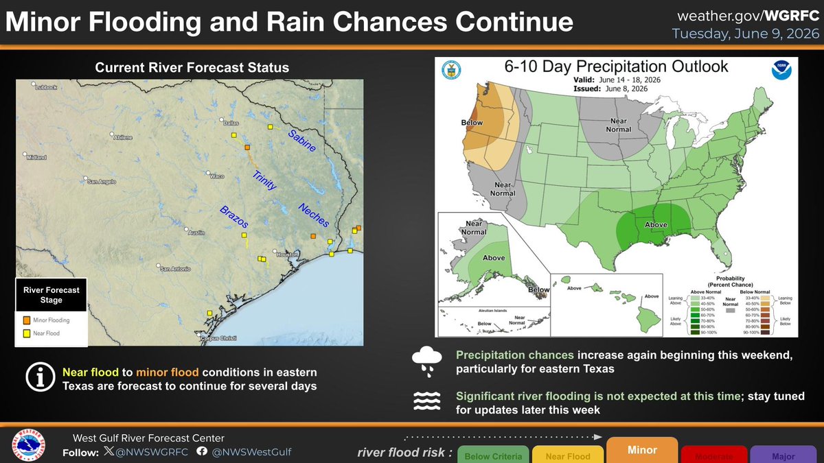
ALT Side by side maps of current river forecast locations in Texas, and a national map of the 6-10 precipitation outlook from the CPC.
Ample rainfall over the last month has led to normal to above normal streamflow levels in rivers across much of the eastern half of Texas. This latest round of rainfall this last weekend resulted in minor river flooding on the Trinity River in North Texas. #txflood
ALT Graphic features last 3 days of observed rainfall and the current river streamflow levels across much of Texas.
Widespread rainfall has been ongoing in North Texas overnight and through this morning with the highest amounts exceeding 4 inches south of the DFW metroplex. This has resulted in river responses including forecast minor river flooding on the Trinity River at Dallas. #txflood
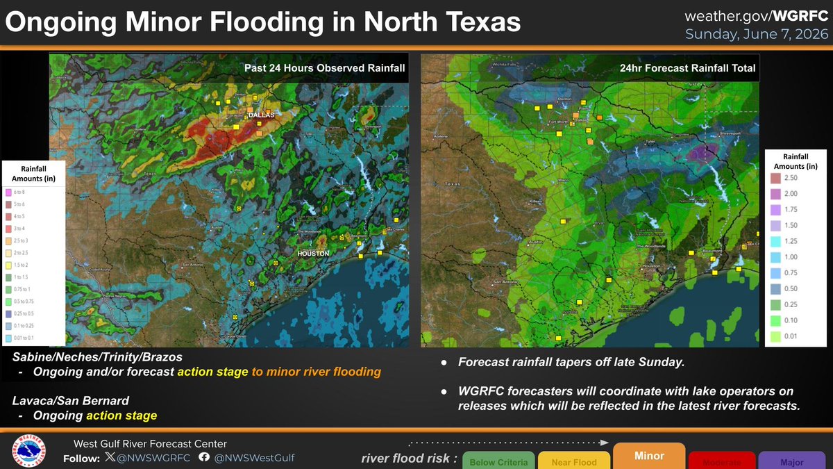
ALT This graphic features the past 24 hours of observed rainfall ending at 7am on Sunday 6/7/2026. The graphic also features the 24 hour rainfall forecast ending Monday 6/8/2026 at 7am.
Heavy rainfall is forecast to continue this evening in much of North and East TX, bringing a potential for new action stage to minor river flooding in the area. Stay weather aware and follow your local weather forecast office for the latest updates. #txwx#txflood
ALT Graphic features the 3 day rainfall forecast and current modeled soil moisture for much of TX.
Rainfall is forecast to continue this weekend for much of North, Central and coastal areas of TX. We are expecting isolated higher flows in rivers where heavier rainfall occurs, but no significant river flooding is forecast. #txwx
ALT Graphic features past 2 days observed rainfall and a 3 day rainfall forecast for Texas.
Upper soils have saturated, especially in the west and along the TX coast, thanks to previous rounds of rain. With weekend rainfall in the forecast, this could lead to some elevated flows in NM and TX though significant river flooding is not expected at this time. #txwx#nmwx
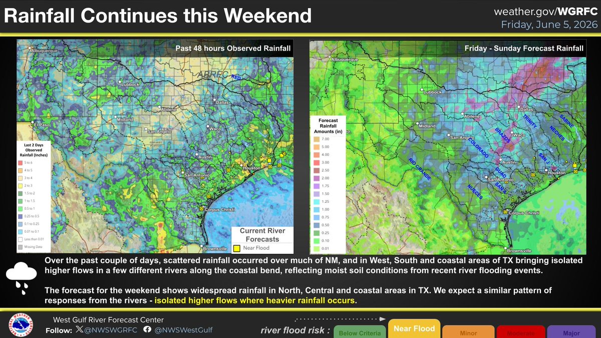
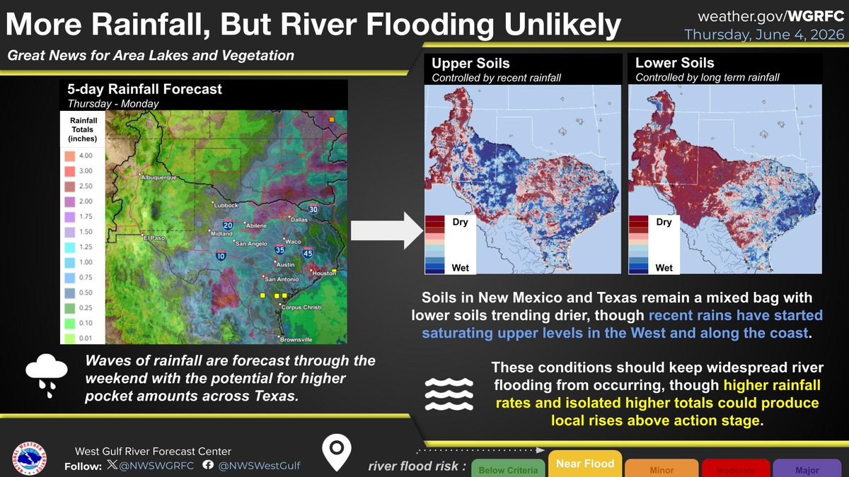
ALT 5-day rainfall totals forecast over the weekend could lead to elevated flows particularly in the west and coastal TX where upper soils are starting to saturate thanks to previous rounds of rain. Significant river flooding is not expected at this time.
While slightly below storage volume from this time last year, reservoirs in the Nueces basin have increased since last month thanks to waves of rainfall. The current flood wave passing through upstream of Lake Corpus Christi will be a welcome addition to the water supply. #txwx
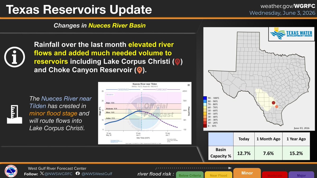
ALT Reservoir storage in the Nueces basin is very low, however, totals have increased over the last month thanks to waves of rainfall. Elevated flows upstream of Lake Corpus Christi are routing downstream to eventually benefit local water supply.
Climate Outlooks for June suggest the possibility for drought improvements in Texas and New Mexico which will be a welcome relief for parched soils. #txwx#nmwx#drought#flood
ALT June Climate Outlooks for drought, precipitation, and temperature suggest that the possibility for drought improvements across TX and NM are in the cards.
Heavy rainfall potential exists for western TX and eastern NM this week. Localized flash flooding is possible, but river flooding is not expected. Stay tuned to your local NWS Weather Forecast Office for flash flood-related updates.
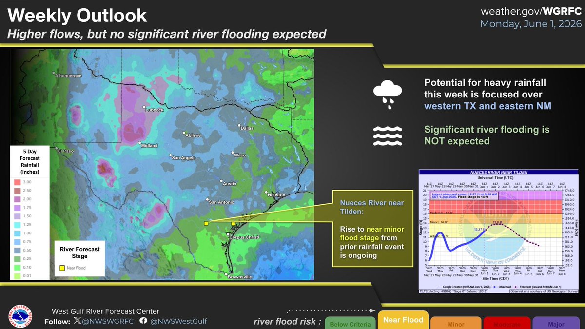
ALT Map of TX and NM with 5 day forecast rainfall amounts and current river forecast locations.
Plentiful rainfall in May has increased river streamflows and improved ongoing drought conditions in Texas, but drought conditions persist across our region. Extreme and worse drought conditions have gradually decreased in area though. #drought#txflooding
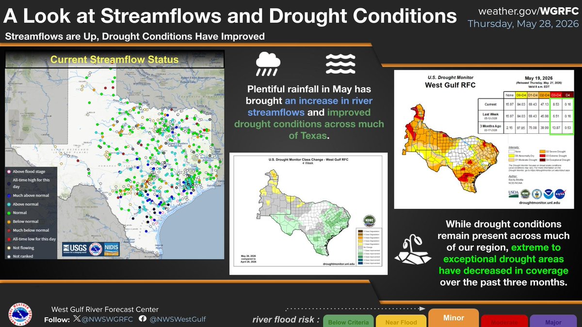
ALT This graphic shows current streamflow status on the left, the one month change in drought conditions in the middle, and current drought conditions on the right.
Here is a look at our current river forecasts in the wake of heavy rainfall yesterday and with some additional rainfall to come. This rainfall, along with plentiful rainfall over the past month, has also resulted in an increase in statewide reservoir storage. #txwx#txreservoirs
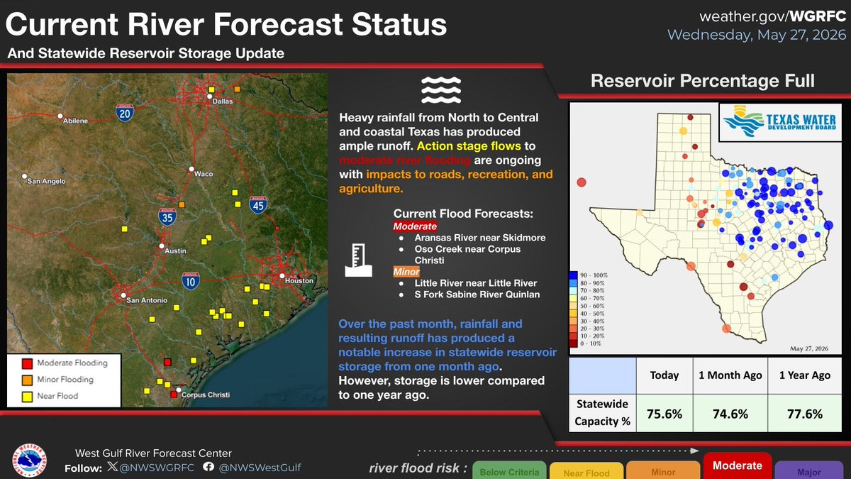
ALT This graphic shows our current river forecasts on the left, showing action stage to moderate flood forecasts. On the right is current statewide reservoir storage, indicating many nearly full reservoirs across most of the state and in increase in storage from one month ago.
Heavy rainfall was observed in NM and western TX over the past 24 hours. While that rainfall is not expected to lead to river flooding, we have issued criteria forecasts in portions of Texas due to forecast rainfall. #nmwx#txwx#txflooding
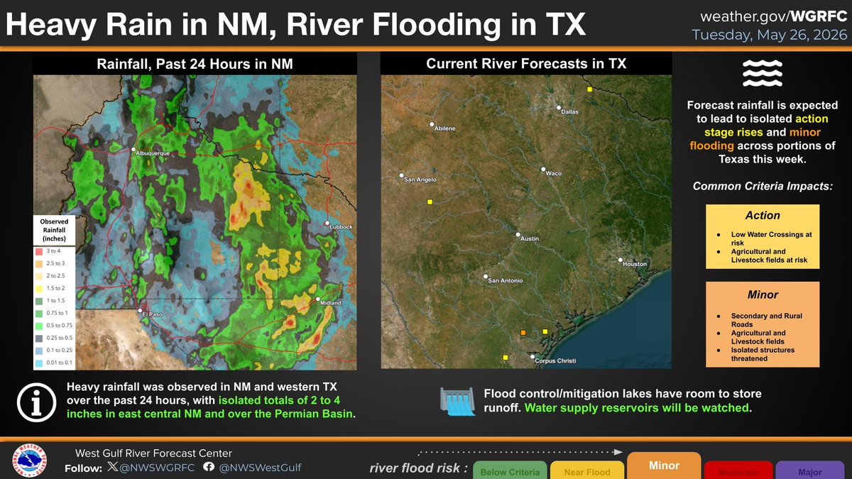
ALT This graphic shows the rainfall over the past 24 hours across New Mexico and western Texas on the left, and the current river flood forecasts for portions of Texas on the right.
Probabilistic river forecasts indicate a chance of isolated minor flooding mid-week,. By late week, there is a low end chance for isolated moderate flooding and more widespread minor flooding across the state. #txflood#txwx
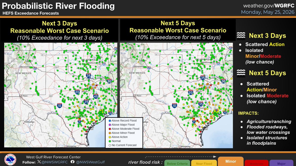
ALT HEFS 3 day 10% Exceedance Left, HEFS 5 day 10% Exceedance Right
Rainfall over the past 5 days was widespread 2-4 inches in Texas with isolated more than 10 inches near the coast. This has made near-surface soils wet in many locations. Additional rainfall in these areas will likely produce runoff and possible river flooding. #txflood#txwx
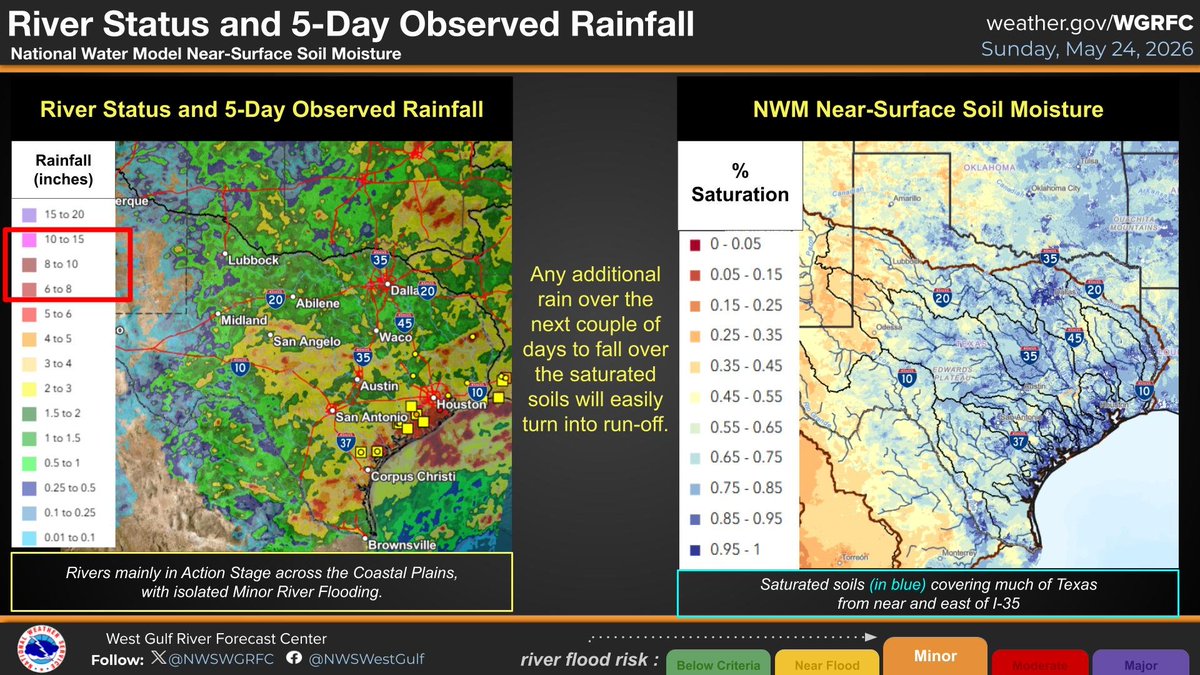
ALT River status and observed 5 day rainfall left, near surface soil moisture right.
Multiple rounds of rainfall mostly impacting Coastal TX, but also scattered areas in Central TX, will continue this weekend. By Sunday there should be more of a focus on southeastern TX. Scattered river flooding can be expected to develop. #txflood#txwx
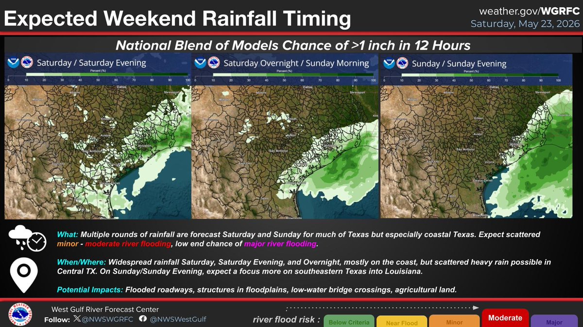
ALT Chance of 1 inch or greater rainfall amounts. Saturday left, Saturday overnight middle, Sunday right