
Official X account for the National Weather Service Weather Prediction Center. Details: weather.gov/twitter
Joined May 2013
- Tweets 40,403
- Following 301
- Followers 332,936
- Likes 4,554
19,455 Photos and videos


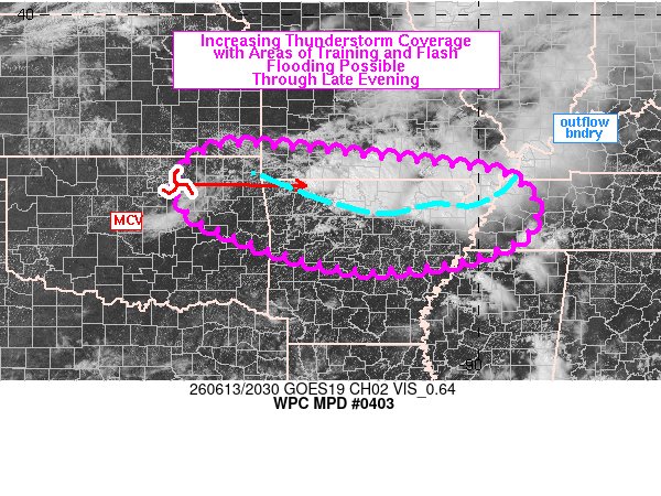


#WPC_MD 0404 affecting eastern TX Panhandle into western OK, #okwx #txwx, wpc.ncep.noaa.gov/metwatch/m…
5
8
4,377
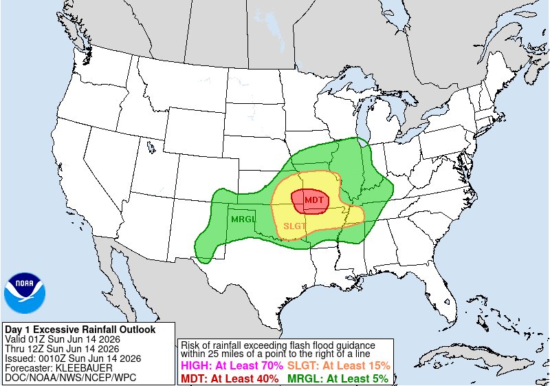
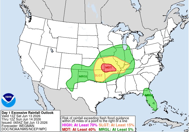
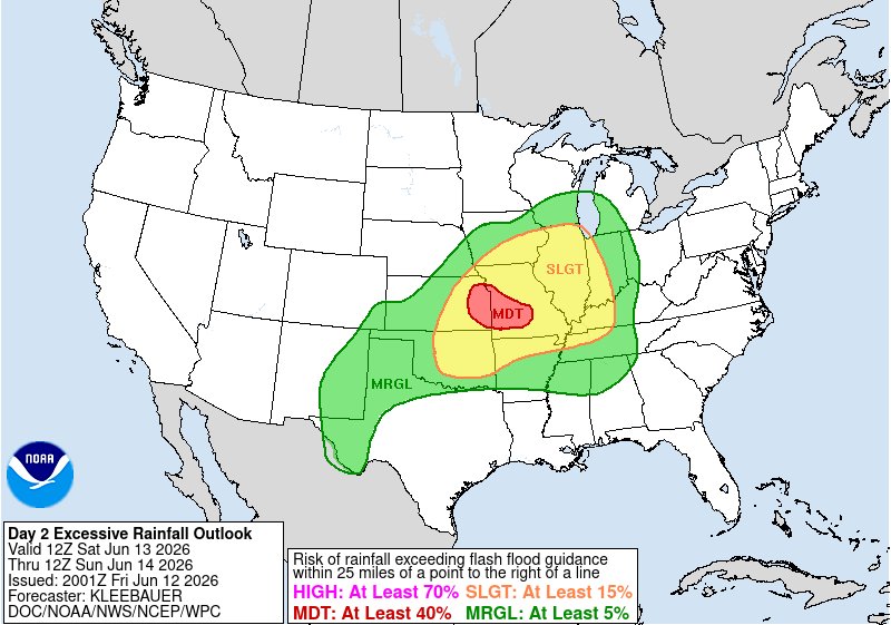
A MODERATE risk is in effect in our Day 1 Excessive Rainfall Outlook. More details: go.usa.gov/cu3Dw
13
34
4,930
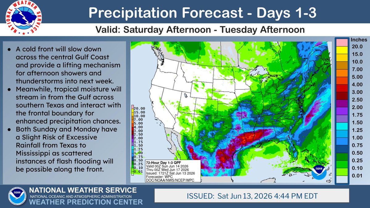
3 day rainfall amounts in the 3-5 inch range are possible from southern Texas to the central Gulf Coast as tropical moisture moves northward from the Gulf and interacts with a slowing frontal boundary over the Gulf Coast. Some scattered instances of flash flooding may occur.
ALT 3 day rainfall amounts in the 3-5 inch range are possible from southern Texas to the central Gulf Coast as tropical moisture moves northward from the Gulf and interacts with a slowing frontal boundary over the Gulf Coast. Some scattered instances of flash flooding may occur.
1
17
67
8,600
NWS Weather Prediction Center retweeted

The National Water Center has issued Key Messages for the Considerable Flash Flooding threat this weekend in the Central Plains and Ozarks. More info: water.noaa.gov #flooding #kswx #mowx

ALT Key Messages for Considerable Flooding in the Central Plains and Ozarks
17
44
21,692
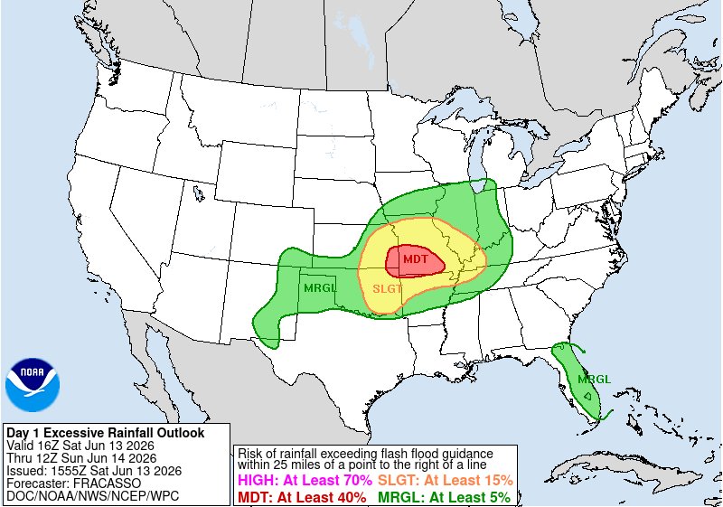
A MODERATE risk is in effect in our Day 1 Excessive Rainfall Outlook. More details: go.usa.gov/cu3Dw
1
19
62
7,839
Heat will build over the Pacific Northwest as much cooler air surges into the mid-section of the country to end the heat in the East go.usa.gov/cu3Wx
2
16
4,954
Strong to severe thunderstorms are forecast to move across the Mid-Atlantic and the Northeast to end the weekend go.usa.gov/cu3Wx
2
26
5,524
Strong to severe thunderstorms capable of producing damaging winds, large hail, and numerous instances of flash flooding are expected to impact the central U.S. today go.usa.gov/cu3Wx
5
37
8,257
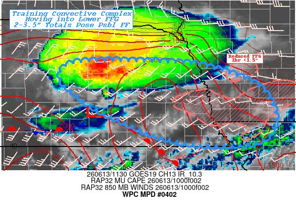
#WPC_MD 0402 affecting Eastern Nebraska...Southwest Iowa...Northwest Missouri..., #iawx #mowx #newx, wpc.ncep.noaa.gov/metwatch/m…
2
17
5,284
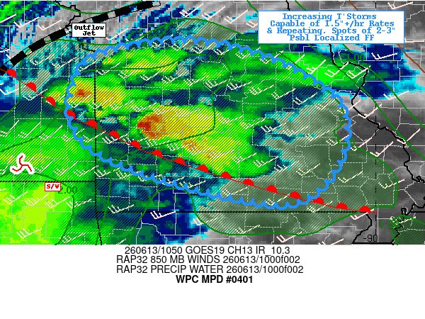
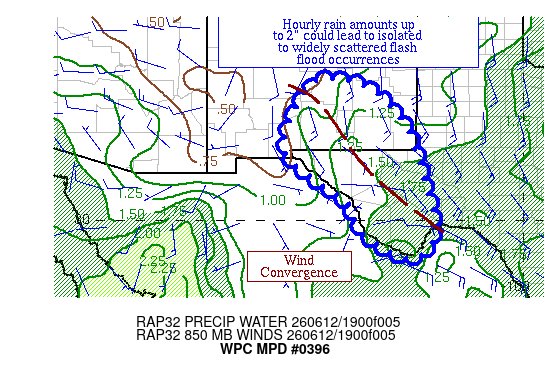
#WPC_MD 0401 affecting Southern & Central Missouri...Far Eastern Kansas..., #mowx #kswx, wpc.ncep.noaa.gov/metwatch/m…
2
13
5,062
A MODERATE risk is in effect in our Day 1 Excessive Rainfall Outlook. More details: go.usa.gov/cu3Dw
1
7
33
4,873
National High/Low temps for Friday June 12, 2026: 119 at Death Valley, CA; 18 at 14 miles west-southwest of Mackay, ID, Peter Sinks, UT #cawx #idwx #utwx go.usa.gov/cu5tP
6
20
5,926
2
15
4,622
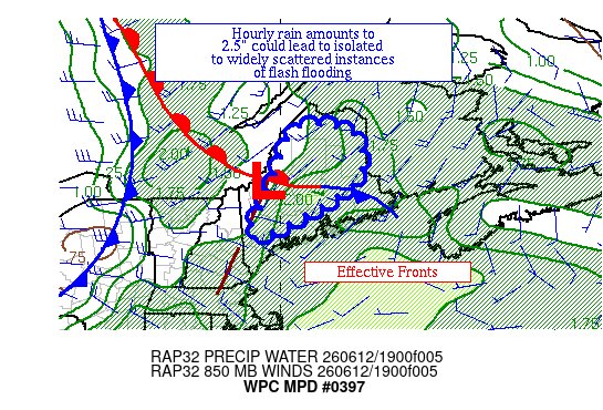
#WPC_MD 0398 affecting in and near central & southern VA, #vawx #ncwx #mdwx, wpc.ncep.noaa.gov/metwatch/m…
3
13
4,090
A Moderate Risk of Excessive Rainfall is in effect for Saturday across eastern Kansas to central Missouri. A couple of rounds of storms capable of producing torrential rainfall are likely ahead of a system moving into the area. Saturated soils will also enhance the flood risk.
ALT A Moderate Risk of Excessive Rainfall is in effect for Saturday across eastern Kansas to central Missouri. A couple of rounds of storms capable of producing torrential rainfall are likely ahead of a system moving into the area. Saturated soils will also enhance the flood risk.
1
19
63
14,791
2
9
3,897