
Weather discussions and information for the Upper Midwest including Minnesota & Wisconsin along with Rochester, Minneapolis & St. Paul.
Joined May 2009
- Tweets 18,939
- Following 362
- Followers 8,799
- Likes 5,881
3,988 Photos and videos
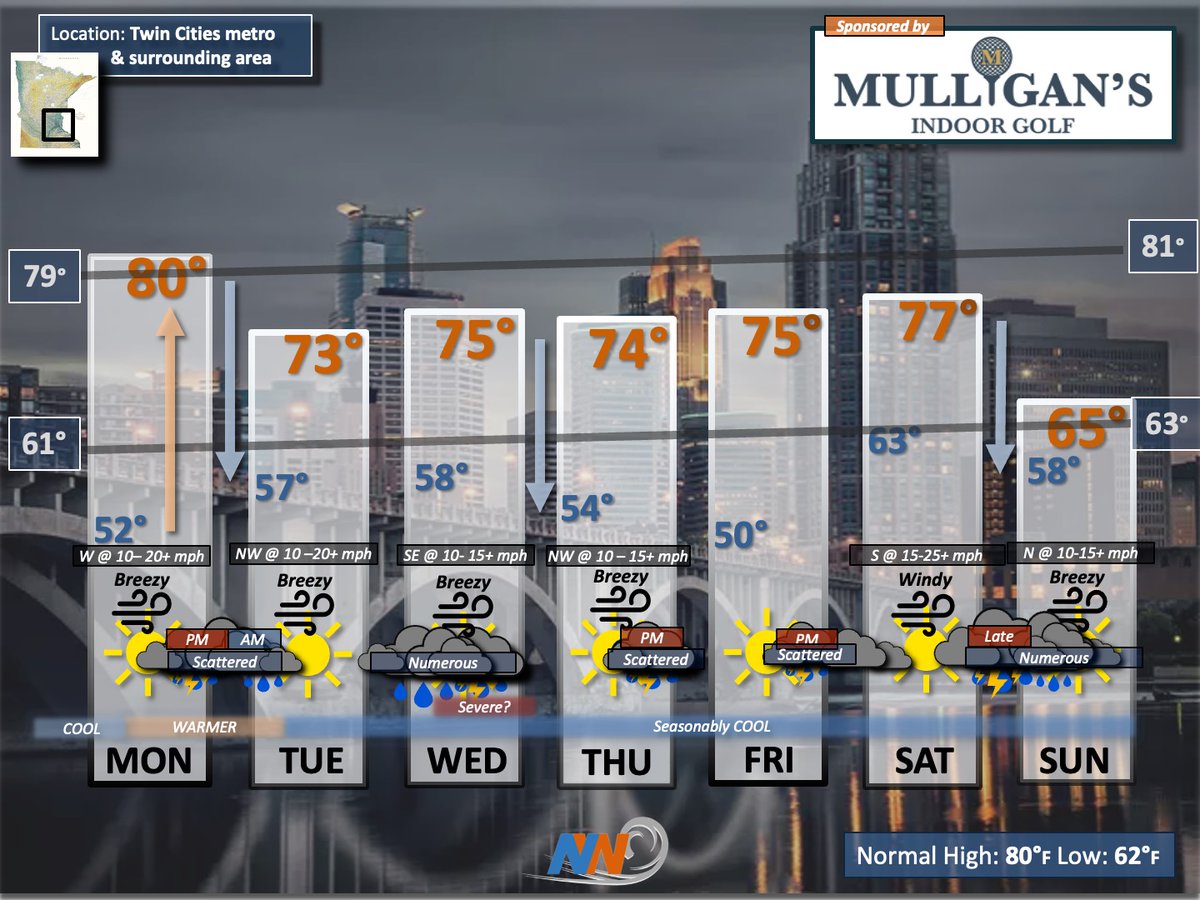


I simply do NOT see any intense summer heat anytime soon as a fast W/NW flow dominates. However, I'm seeing plenty of opportunities for showers & T'Storms. So, if you're looking for a soaking, you're in luck. Here is your extended outlook.
3
2
31
1,492
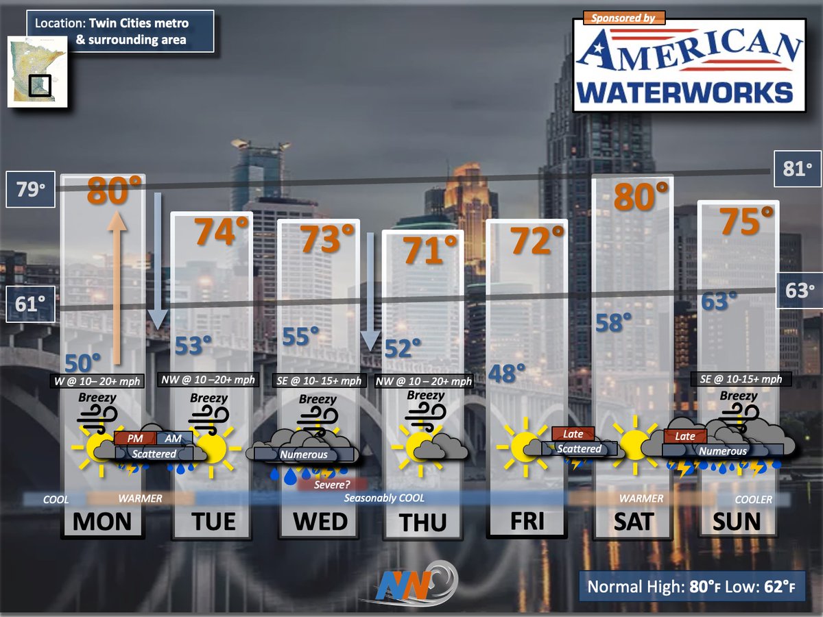
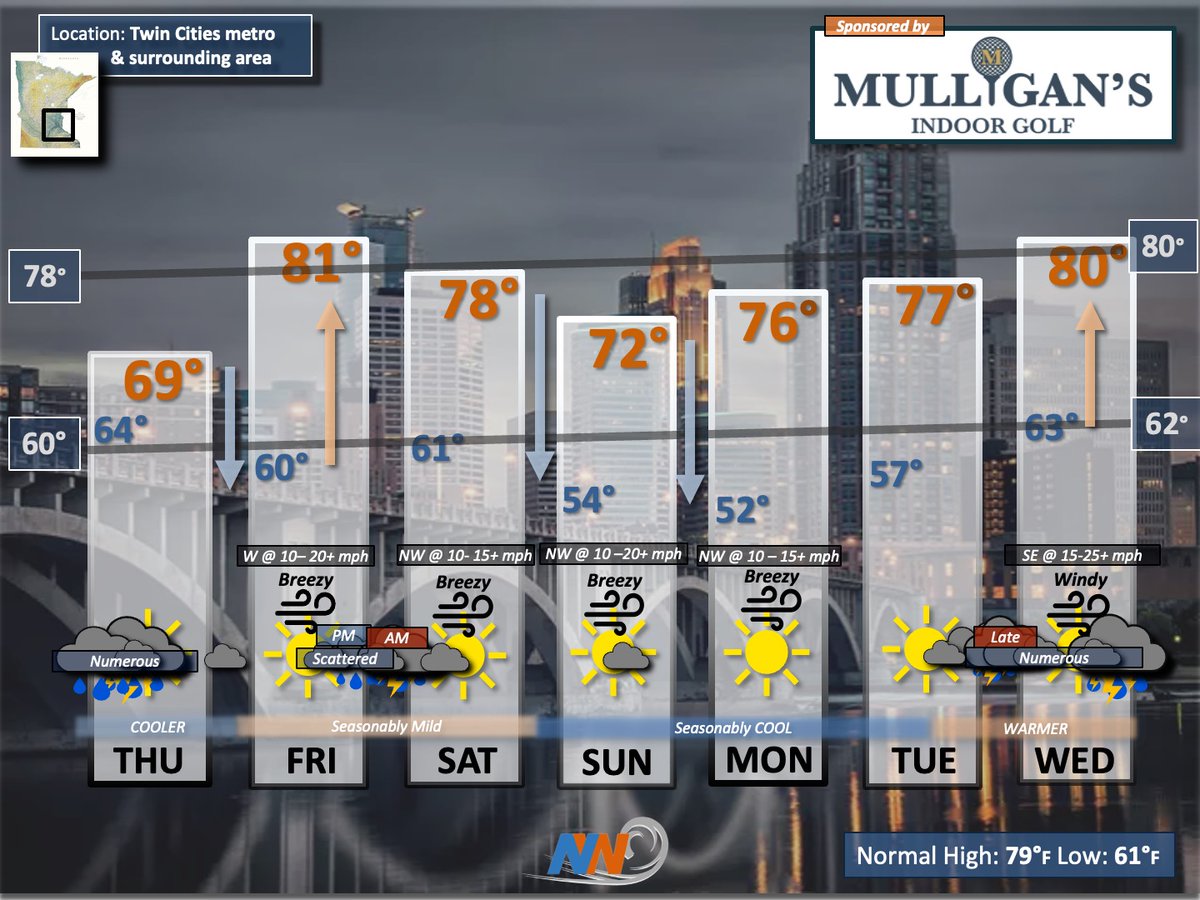
A fast & ACTIVE W/NW flow in our atmosphere = plenty of opportunities for RAIN along with near or below normal temperatures. For many of us, this is just what the Doctor ordered. Here is your extended outlook.
3
1
24
2,504
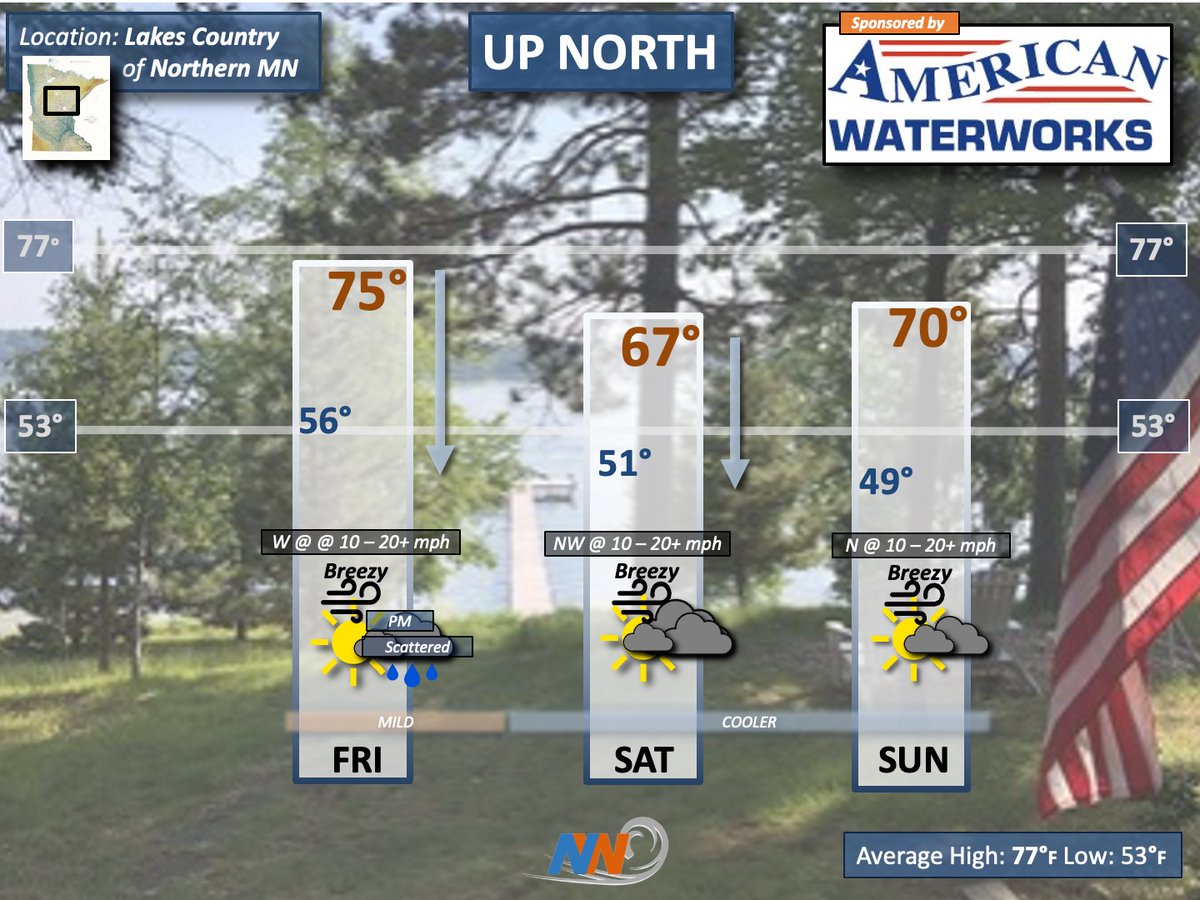
MN Cabin Country will dry out & cool down this weekend as Canadian air seeps south on N/NW winds. In turn, temps will be below normal with sweatshirt conditions likely during the mornings. Here is your 'UP NORTH' outlook.
8
764
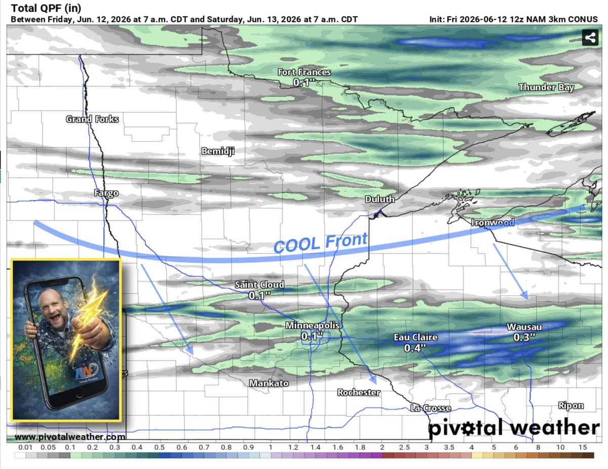
Good news here for some. As a COOL front attempts to surge southeast this evening, a narrow corridor of showers/T'Storms should develop from near the Twin Cities east into central WI. Here is the latest 12z HRRR 24 hour total precipitation potential map.
1
2
21
1,634
Here is the latest DROUGHT Index as of earlier this week. Although we've received some beneficial rains across much of the region, we still need more as summer heat will take a toll over the next couple of months.
2
4
26
2,567
What a beautiful start to the weekend in northwest WISCO. The mostly dry conditions will continue. Meanwhile, as Canadian air seeps south, our temperatures will cool to below normal. All in all, pretty darn nice for mid-June. Here is your 'NORTHWOODS' outlook.
1
7
727
MN Cabin Country will dry out & cool down this weekend as Canadian air seeps south on N/NW winds. In turn, temps will be below normal with sweatshirt conditions likely during the mornings. Here is your 'UP NORTH' outlook.
7
835
Canadian air is on the way & this will lead to temperatures near or below normal thru at least early next week. Meanwhile, mostly dry conditions will be the rule. Here is your extended outlook.
2
18
1,066
Canadian air will be spilling south into northwest WISCO this weekend. In turn, mostly dry, breezy & cooler conditions can be expected. Perfect for an evening bonfire with weenies & smores. Here is your 'NORTHWOODS' outlook.
1
12
893
Skies turn much brighter tomorrow thru early next week. Meanwhile, temperatures will remain near or below normal. Eventually, we turn more active by next WED. Here is your extended outlook.
16
1,136
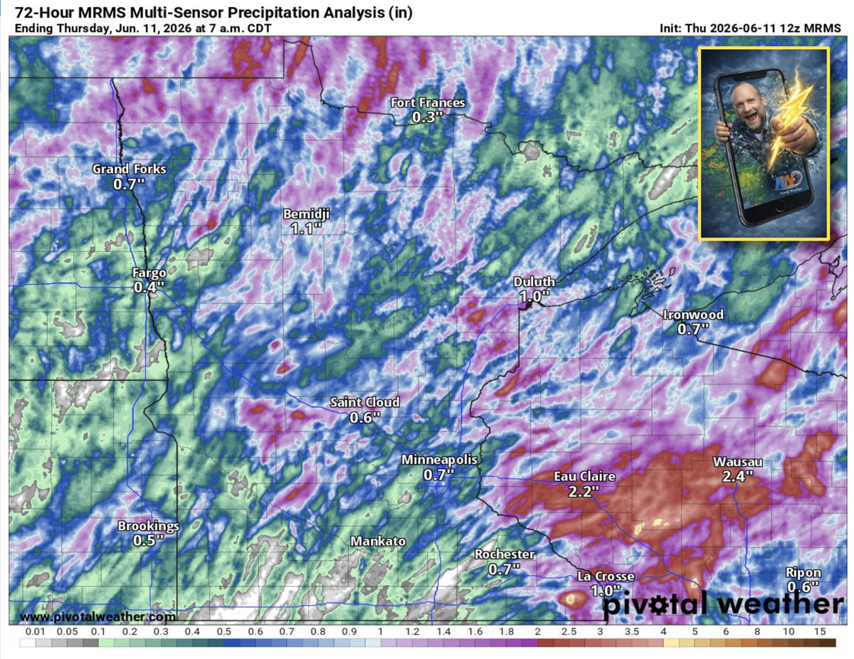
Here are the estimated RAIN totals so far this week. Notice that much of Wisconsin was the big winner in the moisture department. Meanwhile, extreme southern MN mostly missed out.
2
22
2,345
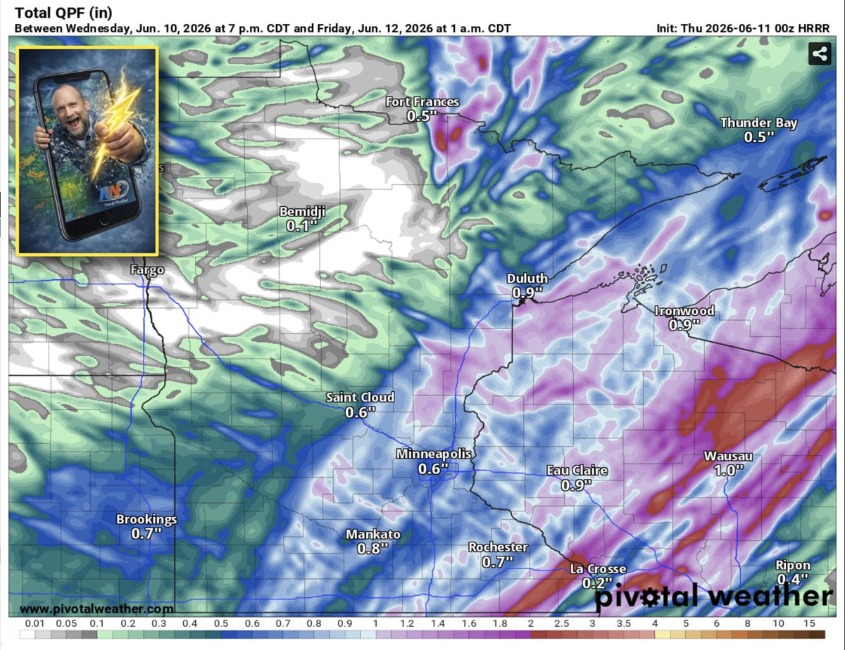
Tomorrow looks like a good soaker for many of us in southern MN & western WI, especially during the afternoon. Here is the latest 00z HRRR potential rain map thru midnight tomorrow.
4
2
38
3,497
After a wet day tomorrow, we begin a nice drying trend as Canadian air seeps south into MN/WI. By this weekend, temps should be near or below normal as breezy NW winds dominate. Eventually, we will warm-up again next week. Here is your extended outlook.
1
2
19
1,687
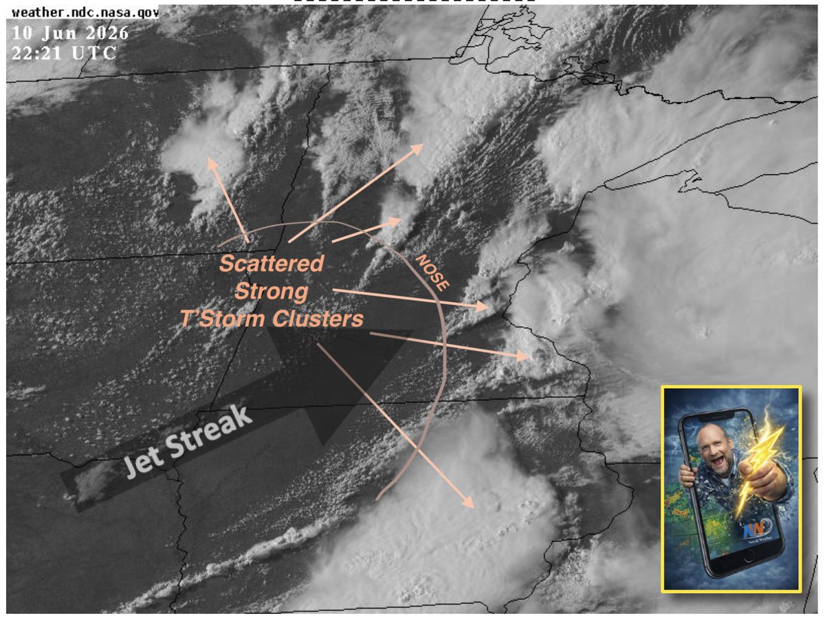
Beautiful visible satellite image showing clusters of T'Storms developing on the nose of a Jet Streak that is surging into southern MN.
3
22
1,939
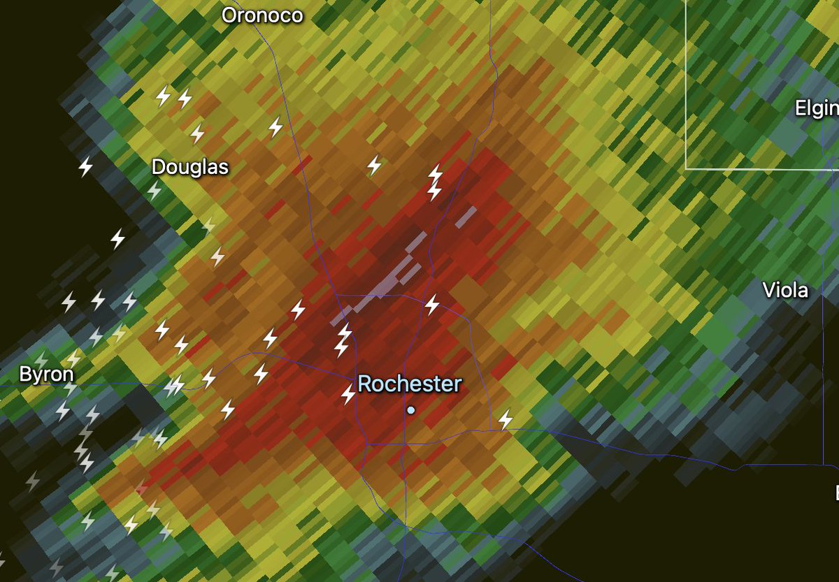
Rochester is under the gun for the next hour or so (thru 5pm) as an intense T'Storm is gaining strength & heading for the metro.
1
2
13
1,496
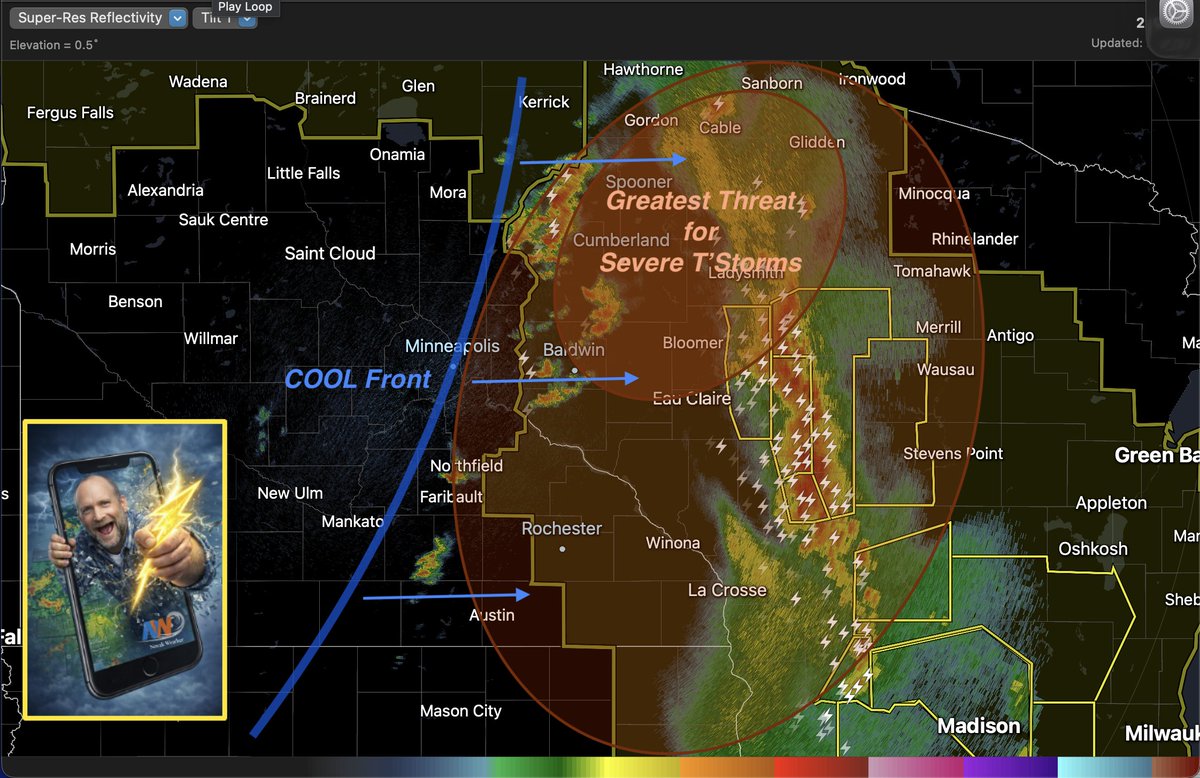
SEVERE threat is waning over eastern MN as a cool front will quickly track east. However, northwest WISCO is under the gun for the next several hours. You can see the T'Storms developing along & ahead of this front on radar. Check it out.
3
1
30
3,264
There is a narrow opportunity for SEVERE weather over eastern MN between 12pm - 5pm this afternoon as a cool front pushes east thru a high energy airmass. So, keep an eye to the sky, especially along & east of the I-35 corridor.

4
5
52
5,039
Guidance continues to strongly hint that a large & potentially SEVERE T'Storm complex (MCS) will roll across MN & western WI after midnight tonight as strong dynamics combine with plenty of energy to keep the complex alive. Here is the set-up.

4
4
54
5,437
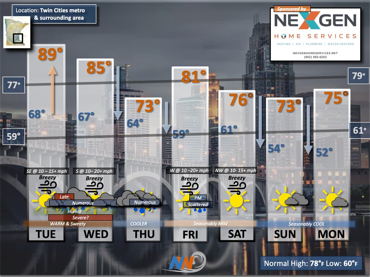
If you're tired of the HEAT & Humidity, I've got good news. Much COOLER conditions will take hold by this weekend. Meanwhile, soaking RAINS are likely the rest of this week. Here is your extended outlook.
3
4
31
2,685
Conditions are looking favorable for a large severe T'Storm complex (MCS) to develop along a cool front in the Dakotas tomorrow evening & track thru MN during the night. This complex would likely contain an impressive squall line. Here is the set-up.

4
13
96
8,194