
Covering the state of Pennsylvania and other important weather events since 2014. 225K on Facebook, Owner Degreed Meteorologist @denysk02
Joined June 2017
- Tweets 8,040
- Following 511
- Followers 5,152
- Likes 2,728
5,465 Photos and videos


** PENNSYLVANIA TIMING OUTLOOK **
Here is a list of as many cities/towns as I can fit on a graphic with the *best* timing to see strong to severe thunderstorms. Keep in mind, this does *NOT* include the potential for showers/storms to occur before the main threat. This is just when the 'best' timing is, as when the atmosphere will be most favorable and/or there is higher model consensus for the best chance for stronger thunderstorms.
FROM THE SEVERE POST:
(ZONE 2, RED): Scattered strong to severe thunderstorms are expected. The strongest storms may pack wind gusts of 60 - 65 mph with hail up to penny-sized. Brief tornadoes may be expected within the line of storms (primarily western PA). Non-severe impacts may include torrential downpours and lightning.
(ZONE 1, YELLOW): Isolated strong to severe thunderstorms are expected. The strongest storms may pack wind gusts of 55 - 65 mph. A brief tornado is possible in the strongest, rotating storm. Non-severe impacts may include torrential downpours and lightning.
-> Keep in mind, severe weather does not impact every house or neighborhood. Unless it is a large outbreak, severe weather impacts will differ even across small areas. It is always good to be prepared by having multiple ways of receiving severe weather alerts and a shelter to take cover in when severe weather strikes. <-
Stay tuned and remain weather aware! #PAwx #Pennsylvania #SevereWeather #Severe #Meteorology
1
5
26
2,127
** SEVERE WEATHER THREAT THIS AFTERNOON / EVENING (SUNDAY 6/14) **
We have a rather unique setup coming this afternoon and evening as a cold front with stronger wind shear and rising temps/humidity will lead to growing instability throughout the afternoon hours, spelling the risk for strong to severe thunderstorms.
Looking over the model guidance, there will be the risk for a squall line to move through western/central Pennsylvania, while there may be the risk for multi/supercells forming off of a convergence boundary in central Pennsylvania, moving into portions of south-central and southeastern Pennsylvania. If a mesolow develops in northwestern PA, this could increase the tornado risk even farther in northwestern PA within the squall line.
BEST TIMING: A 'best' timing graphic will be followed shortly after this post for a lot of the towns/cities in Pennsylvania.
⚠️Like any other severe weather day, take all alerts very seriously. If a tornado/severe watch is issued, this means you should be prepared as the atmosphere is conducive to stronger thunderstorms. If a tornado/severe warning is issued, this means severe weather is imminent, and it is urgent that you take shelter in a sturdy building. ⚠️
(ZONE 2, RED): Scattered strong to severe thunderstorms are expected. The strongest storms may pack wind gusts of 60 - 65 mph with hail up to penny-sized. Brief tornadoes may be expected within the line of storms (primarily western PA). Non-severe impacts may include torrential downpours and lightning.
(ZONE 1, YELLOW): Isolated strong to severe thunderstorms are expected. The strongest storms may pack wind gusts of 55 - 65 mph. A brief tornado is possible in the strongest, rotating storm. Non-severe impacts may include torrential downpours and lightning.
-> Keep in mind, severe weather does not impact every house or neighborhood. Unless it is a large outbreak, severe weather impacts will differ even across small areas. It is always good to be prepared by having multiple ways of receiving severe weather alerts and a shelter to take cover in when severe weather strikes. <-
If you have any questions/concerns, feel free to reach out! #PAwx #Pennsylvania #SevereWeather #Severe #June
5
21
1,335
** ACTIVE SEVERE WEATHER DAY **
Today could be one of the most active severe weather days we've seen lately with the recent model guidance showing the potential for multicell storm segments with squall lines moving through much of western and central Pennsylvania. These storms will have the potential to produce 60 mph winds and the risk for brief, spin-up tornadoes.
Severe weather posts will be going out between 8:25 - 8:30 AM with an updated look at the severe weather outlook with the city-by-town Pennsylvania timing outlook. If you are planning to be outdoors later today, it is crucial that you have ways of receiving severe weather alerts and to have a safety plan in place in the event severe weather strikes your location.
Keep in mind, not every location will get hit by severe weather or rain in fact. That is the nature of summertime convection. Like we've seen recently, some neighborhoods could see tornadoes/damaging winds while 5 miles up the road there was just rain and a breeze. If your location "doesn't see anything", that doesn't mean it is a "bust". Rant over, please heed all warnings seriously today and remain weather aware! If you are aware and have means of receiving severe weather alerts, there is no need to panic.
#PAwx #Pennsylvania #SevereWeather #Meteorology
2
10
64
3,886
Pennsylvania Weather Daily
⛈️ Sunday, June 14
Good morning, Pennsylvania, happy Sunday! After a nice and pleasant day on Saturday, we are closing off the weekend on an active note as we see disturbances and a cold front move through the region. High temperatures will range from the mid 70s to the low-90s across the state, west-to-east. Precipitation will come in the form of showers and thunderstorms, but the timing for each location will vary as there may be different modes of storm types (squall line, multi/supercells). You can also find a localized precipitation timing outlook for your exact location on the website (paweatherplus.com/your-local…)
SEVERE RISK MAP FROM LAST EVENING (NEW UPDATE COMING 8 - 9 AM):
(ZONE 2, RED): Scattered strong to severe thunderstorms are expected. The strongest storms may pack wind gusts of 60 - 65 mph with hail up to penny-sized. A brief tornado or two is possible. Non-severe impacts may include torrential downpours and lightning.
(ZONE 1, YELLOW): Isolated strong to severe thunderstorms are expected. The strongest storms may pack wind gusts of 55 - 65 mph. A brief tornado is possible in the strongest, rotating storm. Non-severe impacts may include torrential downpours and lightning.
Stay tuned and remain weather aware today! #PAwx #Pennsylvania #SevereWeather #Meteorology #June #Summer

3
18
1,344
** WATCHING FOR STRONG TO SEVERE STORMS **
The recent high-resolution models bring a line of strong to severe thunderstorms through western Pennsylvania between 4 - 8 PM tomorrow afternoon and evening (this image is for 6 PM specifically, as it moves northwest-to-southeast). A strong disturbance with an incoming cold front will help to fire up these storms. The environment will be prime with high amounts of wind shear and instability. The one caveat is if we do not get enough sunshine/daytime heating, the risk can be suppressed.
If this line occurs, expect the potential for 60 mph wind gusts and the risk for a brief spin-up tornado or two. Remain weather aware if you are planning to be outdoors tomorrow!
1
8
61
6,115
** SEVERE WEATHER THREAT SUNDAY AFTERNOON / EVENING **
We have a rather unique setup coming tomorrow afternoon and evening as a cold front with stronger wind shear and rising temps/humidity will lead to growing instability throughout the afternoon hours, spelling the risk for strong to severe thunderstorms.
Looking over the model guidance, there will be the risk for a squall line to move through western/central Pennsylvania, while there may be the risk for multi/supercells forming off of a convergence boundary in central Pennsylvania, moving into portions of south-central and southeastern Pennsylvania.
Given the two storm types, some areas may see more than one round of stronger thunderstorms. The best timing currently varies, but storms may begin to fire as early as 12 - 2 PM, with the main squall line moving through western/central PA after 4 PM and through the evening.
(ZONE 2, RED): Scattered strong to severe thunderstorms are expected. The strongest storms may pack wind gusts of 60 - 65 mph with hail up to penny-sized. A brief tornado or two is possible. Non-severe impacts may include torrential downpours and lightning.
(ZONE 1, YELLOW): Isolated strong to severe thunderstorms are expected. The strongest storms may pack wind gusts of 55 - 65 mph. A brief tornado is possible in the strongest, rotating storm. Non-severe impacts may include torrential downpours and lightning.
-> Keep in mind, severe weather does not impact every house or neighborhood. Unless it is a large outbreak, severe weather impacts will differ even across small areas. It is always good to be prepared by having multiple ways of receiving severe weather alerts and a shelter to take cover in when severe weather strikes. <-
If you have any questions/concerns, feel free to reach out! #PAwx #Pennsylvania #SevereWeather #Severe #June
11
75
6,596
Wow! What an ominous look of incoming severe thunderstorms in Pittsburgh, Pennsylvania, from Thursday afternoon. Thank you for sharing, Trish Williams Mann! Trish (FB) also noted a lot of vendors' tents were damaged at the Three Rivers Arts Festival.
1
15
877
Pennsylvania Weather Daily
☀️ Saturday, June 13
Good morning, Pennsylvania, happy Saturday! We have quite a nice Saturday in store across the state as high temperatures will climb into the upper 70s to upper 80s across the state under mostly sunny skies. It has been so rare for us lately to have a sunny and warm Saturday, so make sure to enjoy it! The humidity will be much lower, thanks to yesterday's cold front passage, so it will feel comfortable despite the higher temperatures in a few spots.
⚠️ Thunderstorms, some strong to severe, return to the state on Sunday. Make sure to stay tuned for updates!
#PAwx #Pennsylvania #Sunshine #June #Weekend #Weather

3
16
749
Incredible views of the sky after strong thunderstorms on Thursday afternoon. Thank you for sharing, Jennier Intintolo (FB)! What did the sky look like in your region after the storms over the last few days?
1
1
19
678
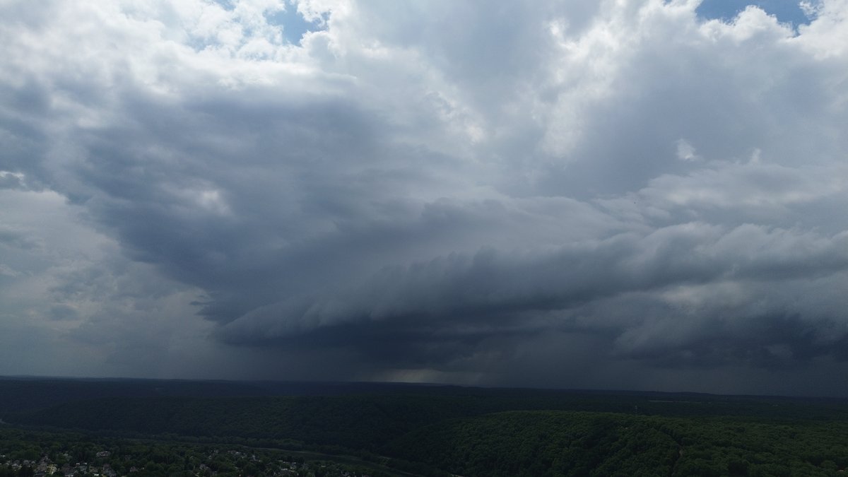
Spectacular views of a shelf cloud Thursday afternoon in Oil City, Pennsylvania. Thank you for sharing Elijah!


2
17
1,059
The storms on Thursday afternoon produced some cool views, including here in Sarver, Butler County, Pennsylvania, with a gnarly-looking shelf cloud. Thank you for sharing, Jen Walker!
1
1
20
646
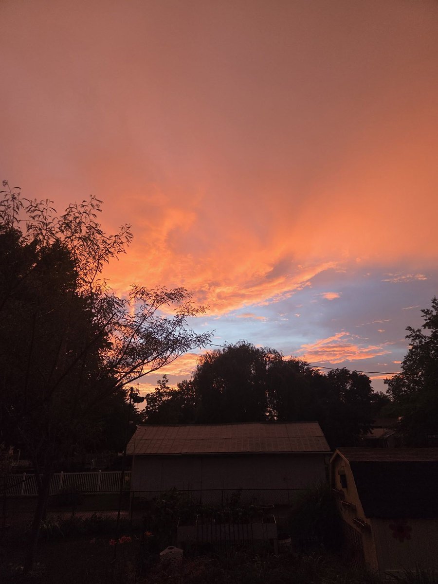
Sometimes the best sunsets occur after a stormy afternoon and evening. This is from Selinsgrove, Pennsylvania, Thursday evening. Thank you for sharing, Cathy M Engle!
1
1
16
537
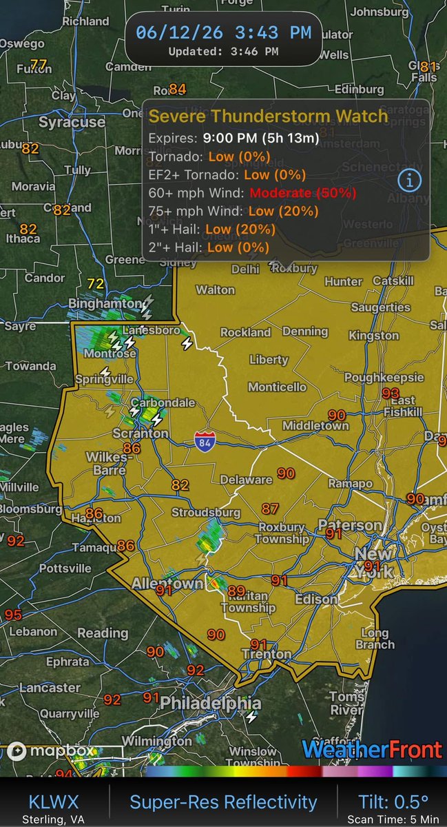
⚠️ SEVERE THUNDERSTORM WATCH ISSUED FOR NORTHEAST PENNSYLVANIA ⚠️
A Severe Thunderstorm Watch has been issued for Northeast Pennsylvania until 9:00 PM this evening.
Thunderstorms are expected to increase in coverage through the afternoon and evening as they move east-southeast across the region. Some storms may become severe, with the primary threat being damaging wind gusts of 60 to 70 mph capable of downing trees, causing power outages, and producing localized damage.
In addition to strong winds, the most intense storms may also produce hail up to 1 inch in diameter.
Areas including the Poconos, Scranton/Wilkes-Barre region, and surrounding communities should remain weather-aware through this evening.
Main Threats:
• Damaging wind gusts up to 70 mph
• Isolated hail up to 1 inch in diameter
• Frequent lightning and torrential downpours
Remember, a Severe Thunderstorm Watch means conditions are favorable for severe thunderstorms to develop. It does not mean severe weather is occurring everywhere in the watch area, but you should be prepared to take action if warnings are issued! Stay tuned!
1
1
10
697
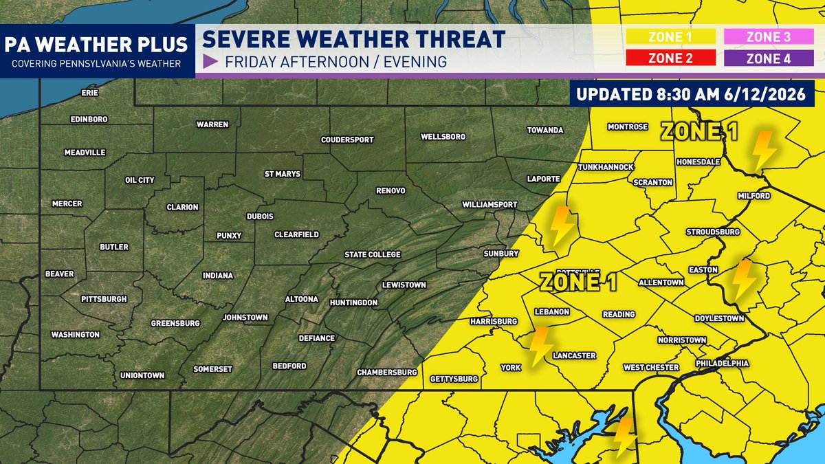
** ISOLATED FRIDAY SEVERE THREAT **
A cold front will push through the state today, allowing for another risk of strong thunderstorms, with the best chance in eastern Pennsylvania. The limiting factor today is that there will be a good bit of dry air and a "capping" inversion in the lower atmosphere, which will help to prevent a lot of the thunderstorms from developing. The wind shear will also be on the weaker side, which will help prevent a lot of the convection that does develop to mostly remain sub-severe. This is why the risk remains isolated at best.
(ZONE 1, YELLOW): Isolated strong to severe thunderstorms are expected. The strongest storms may pack wind gusts of 50 - 60 mph. A tornado is very unlikely. Non-severe impacts may include torrential downpours and lightning.
-> Keep in mind, severe weather does not impact every house or neighborhood. Unless it is a large outbreak, severe weather impacts will differ even across small areas. It is always good to be prepared by having multiple ways of receiving severe weather alerts and a shelter to take cover in when severe weather strikes. <-
If you have any questions/concerns, feel free to reach out!
#PAwx #Pennsylvania #SevereWeather #Severe #June
3
16
867
Pennsylvania Weather Daily
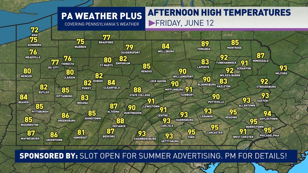
⛈️⛅ Friday, June 12
Good morning, Pennsylvania, happy Friday! We have another hot day ahead of us across portions of central and eastern PA as high temperatures will climb into the upper 80s to lower 90s, but it will cool down in western PA with a cold front coming through. With the front dissecting the state today, there will be another risk of strong thunderstorms, primarily in eastern PA. There is another uncertainty with the storms today, as it will be dependent on whether a "cap" layer in the lower atmosphere is able to break through. If it breaks through, expect some strong to severe storms. If not, it will be mostly dry.
A more severe weather update will be out between 8 - 9 AM.
Stay tuned for updates! #PAwx #Pennsylvania #Weather #June #Summer #Thunderstorm

6
23
1,197
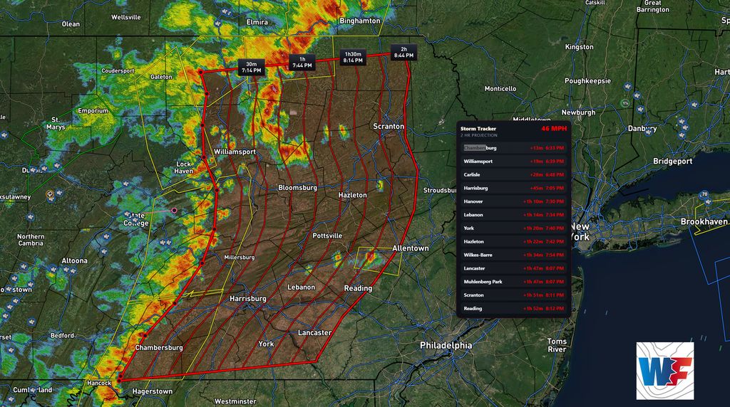
STORMS CONTINUE TO PUSH EAST... 6:45 PM 6/11/2026
A line of strong to severe thunderstorms continues to push eastward through central Pennsylvania this evening. These will begin to move into eastern Pennsylvania toward sunset. Most of the line is still severely warned at 6:45 PM, so expect gusts of up to or greater than 60 mph in spots within the line. As we start to lose some of the daytime heating, the intensity will begin to wane, but still expect gusts of 45 - 55 likely all the way up to the eastern PA border this evening.
Remain weather aware and be prepared for rapidly changing conditions! #PAwx #Pennsylvania #SevereThunderstorm
1
1
22
1,443
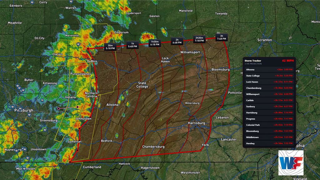
** STRONG - SEVERE STORMS PUSHING EASTWARD **
4:51 PM 6/11/26
A decent-sized squall line has developed this afternoon, although a bit farther south than my projections this morning. Nevertheless, it is currently severe and has produced 70 mph wind gusts and damage across the Pittsburgh region. This squall line is moving roughly 40 - 45 mph to the east, and will be moving into much of central PA over the next 3 hours. Expect continued wind gusts of 55 - 65 mph, heavy rainfall, and frequent lightning.
Given the unstable airmass in place, I don't expect this to fall apart until closer to sunrise. These storms could make it into eastern Pennsylvania between 7 - 9 PM, but likely begin to weaken, but still could see 50 gusts in spots.
Stay tuned for updates and remain weather aware!
1
19
1,362
⚠️ SEVERE THUNDERSTORM WATCH ISSUED FOR WESTERN PENNSYLVANIA ⚠️
A Severe Thunderstorm Watch has been issued for much of Western Pennsylvania until 8:00 PM this evening.
Conditions are favorable for the development of severe thunderstorms capable of producing damaging wind gusts up to 65 mph and isolated large hail up to 1.5 inches in diameter. Thunderstorms are expected to develop and organize into clusters this afternoon and evening as they move from west to east across the region.
The primary threat will be damaging straight-line winds that could bring down trees, power lines, and cause scattered power outages. While the main concern is wind, a few storms may also produce large hail.
If you have outdoor plans this afternoon or evening, stay alert to changing weather conditions and be prepared to seek shelter if warnings are issued. We will continue to provide updates as storms develop across Western Pennsylvania.
Remember: A Severe Thunderstorm Watch means conditions are favorable for severe weather. It does NOT mean severe weather is occurring yet, but you should be prepared to act if warnings are issued

3
12
734
** STRONG/SEVERE PM STORMS **
The recent high-res model guidance is showing the potential for strong to severe storm segments to fire up across the state later this afternoon and evening. The best dynamics will be situated through much of central and eastern Pennsylvania. Don't focus on the exact timing of this simulated radar, but the greater picture shows the risk for the best storms to congeal near the I-80 corridor. These then would dive east/southeast into the evening hours, bringing the risk to areas such as Allentown and possibly into Philadelphia.
The biggest questions:
- Where will the initial storm complex fire up this afternoon? The main batch of storms that fire between 11 AM - 1 PM across northwestern PA will need to be watched as it could become the main batch.
- Will outflow boundaries from these storms help to push the line more south or more east? There is enough wind shear to push these storms, but it is a question if they can turn into brief bowing strong wind segments.
Stay tuned for updates, and as always, remain weather aware. #PAwx #Pennsylvania #Storm #Meteorology

1
18
1,305
THURSDAY (6/11) SEVERE WEATHER TIMING...
Here is a city-by-city outlook for the timing of severe weather this afternoon and evening. I am watching for a disturbance to move out of the Midwest that will spark off strong to severe thunderstorms as they move into a very hot and unstable airmass. The best threat looks to start north around I-80 before slowly expanding and diving south/southeast throughout the afternoon and evening hours.
(ZONE 2, RED): Scattered strong to severe thunderstorms are expected. The strongest storms may pack wind gusts of 60 - 65 mph with hail up to penny-sized. A tornado is very unlikely. Non-severe impacts may include torrential downpours and lightning.
(ZONE 1, YELLOW): Isolated strong to severe thunderstorms are expected. The strongest storms may pack wind gusts of 55 - 65 mph. A tornado is very unlikely. Non-severe impacts may include torrential downpours and lightning.
-> Keep in mind, severe weather does not impact every house or neighborhood. Unless it is a large outbreak, severe weather impacts will differ even across small areas. It is always good to be prepared by having multiple ways of receiving severe weather alerts and a shelter to take cover in when severe weather strikes. <-
Stay tuned and remain weather aware! #PAwx #Pennsylvania #SevereWeather #Severe #Meteorology

3
9
1,283