தமிழக வானிலை ஆர்வலர். Chennai based Regional Weather Tracker. Your trusted source for South Indian Weather Forecasts.
Joined January 2016
- Tweets 18,378
- Following 180
- Followers 13,561
- Likes 42,038
6,643 Photos and videos


Pinned Tweet

5 Nov 2025
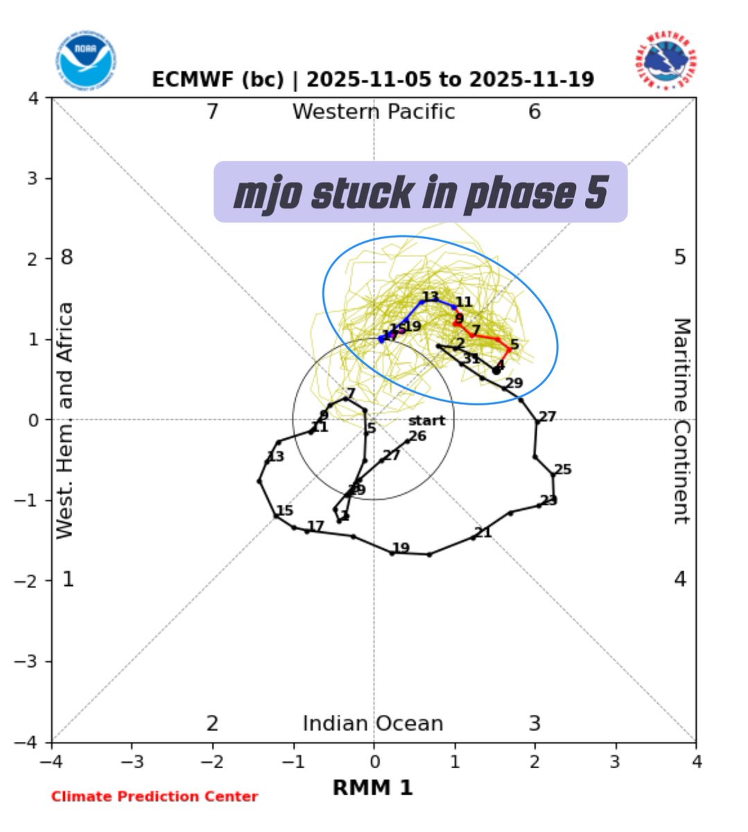
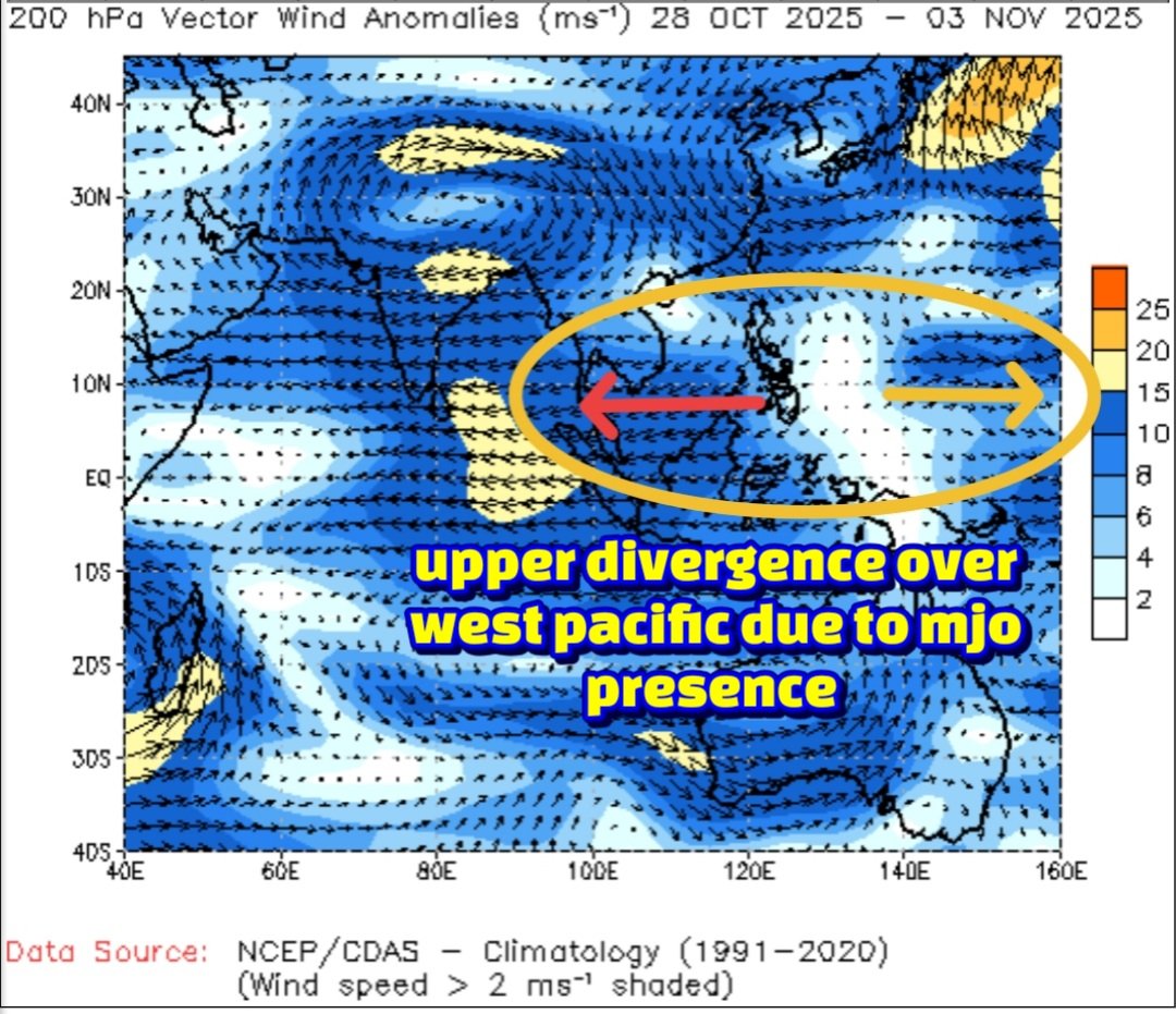
🌀 Understanding the MJO: Why it Appears "Stuck"!
The Madden-Julian Oscillation (MJO) is a naturally occurring, eastward-propagating weather system that cycles through eight distinct phases over a typical period of 30 to 60 days. It does not permanently "get stuck" in any single phase; any apparent lingering, particularly in phases 5-8, is a temporary part of its naturally irregular cycle, influenced by several complex atmospheric and oceanic factors.
⏳ Key Reasons for MJO Slowdown or Lingering: The appearance of the MJO "stuck" in phases 5, 6, 7, or 8 (the Western Pacific to Western Hemisphere) is generally due to the following reasons:
Interaction with the Maritime Continent (Phases 4 & 5):
Phases 4 and 5 occur over the Maritime Continent (Indonesia and the West Pacific). The numerous islands and mountains in this region disrupt the MJO's large-scale convection, slowing its eastward progression and making it notoriously difficult for weather models to predict accurately. Tracking its progress often relies on methods like Outgoing Longwave Radiation (OLR) measurements.
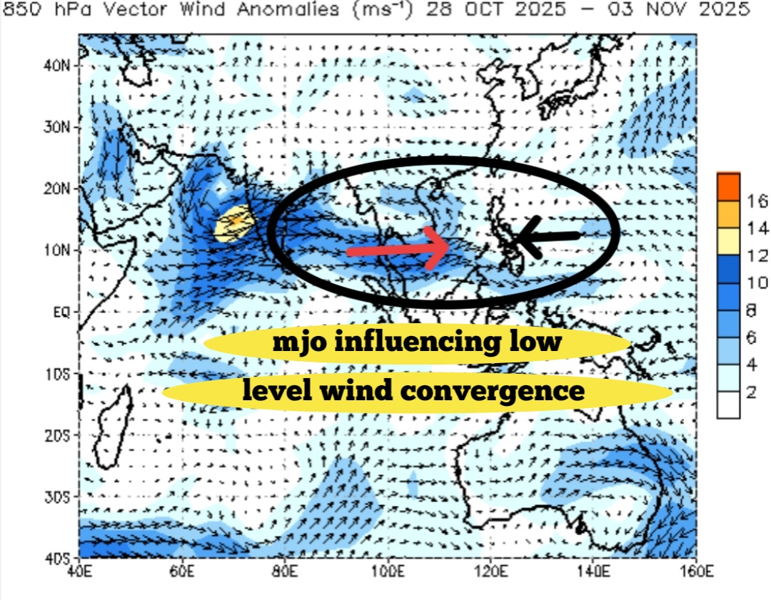
Interference from Major Climate Drivers:
The MJO's signal can be temporarily masked or slowed down by interactions with other large-scale climate patterns. A developing La Niña phase, for example, can suppress the MJO's propagation, effectively "killing the spirit" of its movement. This interference is often visible when Equatorial Rossby Waves (ERW) emerge to the west of the MJO location.
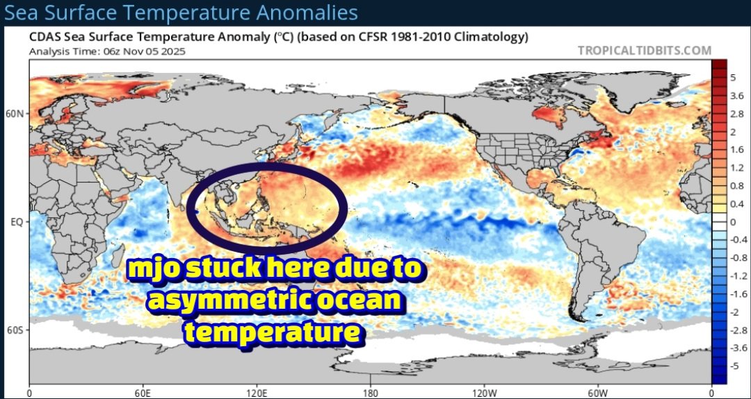
Asymmetric Ocean Warming and LaNiña:
Changes in regional sea surface temperatures, exacerbated by asymmetric ocean warming, have altered the MJO's speed. Slower propagation, particularly over the Western Pacific, can be linked to the developing or "immature" phase of a La Niña event.
Natural Variability:
The MJO's propagation is rarely smooth. Its cycle length naturally varies, sometimes extending up to 90 days. It can also become dormant for periods, contributing to the perception of it being stalled.
Model Limitations:
Current global climate models often struggle to simulate the MJO with perfect accuracy, especially over the complex geography of the Maritime Continent. This can lead to forecast runs that incorrectly show the MJO lingering in a specific phase longer than it does in reality.
🌧️ Northeast Monsoon 2025 Forecast Implications:
The MJO's current behavior holds significant implications for the Northeast Monsoon (NEM) 2025, which affects regions like Chennai.
Scenario 1: MJO Lingers (Negative Impact): If the MJO remains strong in the West Pacific (Phases 6-8) or continues to linger there until the end of November, it is likely to disrupt the monsoon flow over Southern India, potentially leading to a deficit in the Northeast Monsoon.
Scenario 2: MJO Weakens (Positive Impact): If the MJO weakens in the West Pacific or progresses quickly through its phases, it increases the likelihood of a normal NEM performance.
Note: The exact forecast track for the MJO is crucial and typically requires waiting for updates around the 10th of November for a clearer picture.
10
26
155
53,982
16 ஜூன் 2026: தமிழ்நாடு வானிலை எச்சரிக்கை: மாலைக்குள் தென் மாவட்டங்களில் பரவலான இடியுடன் கூடிய மழை பெய்யக்கூடும். கடல் காற்று சங்கமம் (Sea Breeze Convergence) காரணமாக, சென்னை மற்றும் புறநகர்ப் பகுதிகளில் மதியம் அல்லது மாலையில் தொடர்ந்து இரண்டாவது நாளாக குறுகிய கால இடியுடன் கூடிய மழைக்கு வாய்ப்புள்ளது!
வானிலை சூழல் மற்றும் வளிமண்டல நிலவரம்:
கடல் காற்று சங்கமம்: மதிய வேளையில் ஏற்படும் கடல் காற்று சங்கமம், தமிழ்நாட்டின் அனைத்து கடலோரப் பகுதிகளிலும் வெப்பச்சலன நிகழ்வுகளைத் தூண்டும்; இது நேற்றைய வானிலை அமைப்பைப் போலவே இருக்கும் (மதிய நேர சங்கம கணிப்புகளுக்குப் படத்தைப் பார்க்கவும்).
கிடைக்கக்கூடிய ஆற்றல்: சென்னை முதல் தூத்துக்குடி வரையிலான கடலோரப் பகுதிகள் முழுவதும், வெப்பச்சலனத்திற்குத் தேவையான ஆற்றல் (CAPE) மிகவும் சாதகமாக உள்ளது (தீவிர CAPE விவரங்களுக்குப் படத்தைப் பார்க்கவும்).
சுழற்சி செயல்பாடு: வளிமண்டலத்தின் கீழ் அடுக்குகளில் தென் பிராந்தியத்தின் மீது ஒரு ஆழமான சுழற்சி நிலவுகிறது, இது மழைக்கான வாய்ப்பை அதிகரிக்கிறது (படத்தைப் பார்க்கவும்).
காற்றின் திசைவேக மாற்றம் (Wind Shear) & தடுப்பு நிலை: மதியம் முதல் தென் தமிழ்நாட்டில் காற்றின் திசைவேக மாற்றம் அதிகமாகவும், வட தமிழ்நாட்டில் மிதமாகவும் இருக்கும். குறிப்பாக, வட கடலோரப் பகுதிகளில் நிலவும் எதிர்மறை வெப்பச்சலனத் தடுப்பு நிலை (negative Convective Inhibition), அப்பகுதியில் உருவாகும் இடியுடன் கூடிய மேகங்களை விரைவாக வலுவிழக்கச் செய்யும்.
பிராந்திய வாரியான மழை முன்னறிவிப்பு:
தென் தமிழ்நாடு
முன்னறிவிப்பு: கடல் காற்று சங்கமம் மற்றும் கீழ் அடுக்கு சுழற்சி ஆகியவற்றின் கூட்டு விளைவால், மாலைக்குள் பரவலான மிதமான இடியுடன் கூடிய மழை பெய்யக்கூடும்.
பாதிக்கப்படும் முக்கிய மாவட்டங்கள்: தூத்துக்குடி, திருநெல்வேலி, விருதுநகர் மற்றும் ராமநாதபுரம்.
சென்னை மற்றும் வட கடலோரப் புறநகர்ப் பகுதிகள்
முன்னறிவிப்பு: தொடர்ந்து இரண்டாவது நாளாக, கடல் காற்று வீசத் தொடங்குவதால் மதியம் 2:00 மணி முதல் 3:00 மணிக்குள் உள்ளூர் அளவில் வெப்பச்சலன நிகழ்வுகள் ஏற்படும். கனமழைக்கு பதிலாக, தீவிரமான ஆனால் குறுகிய கால மற்றும் ஆங்காங்கே நிகழும் லேசான இடியுடன் கூடிய மழையை எதிர்பார்க்கலாம்.
பாதிக்கப்படும் முக்கிய மாவட்டங்கள்: சென்னை நகரம் (மாலை அல்லது இரவு நேரங்களில் சில இடங்களில் மழை பெய்யலாம்), திருவள்ளூர், ராணிப்பேட்டை, காஞ்சிபுரம் மற்றும் செங்கல்பட்டு.
உள் மாவட்டங்கள் மற்றும் பிற பகுதிகள்
லேசான முதல் மிதமான இடியுடன் கூடிய மழை (மாலை/இரவு): திருவண்ணாமலை, கோயம்புத்தூர், விழுப்புரம், புதுச்சேரி, கடலூர், பெரம்பலூர், அரியலூர், திண்டுக்கல், தேனி மற்றும் தென்காசி மாவட்டங்களில் எதிர்பார்க்கப்படுகிறது. லேசான மழை அல்லது இடியுடன் கூடிய மழை (மாலை): வேலூர், மயிலாடுதுறை மற்றும் தர்மபுரி மாவட்டங்களில் பெய்யக்கூடும்.
1
12
519
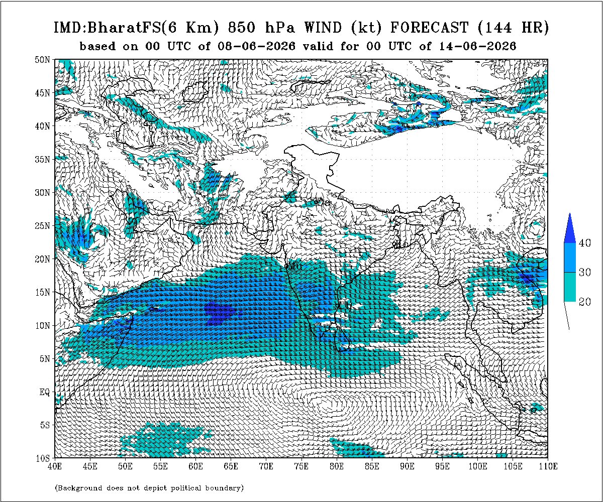
#Mumbai monsoon onset likely around 20-22nd June.
As per the models indication, the westerly wind picking up moisture and onset of monsoon over Mumbai city likely around 20-22nd June. This is 4th time, the delayed start since 2015 elnino year. During this time the remaining parts of Telangana, Maharashtra, Jharkhand, Odisha, Chattisgarh and parts of Bihar will also be in line for monsoon onset.
5
7
109
7,184
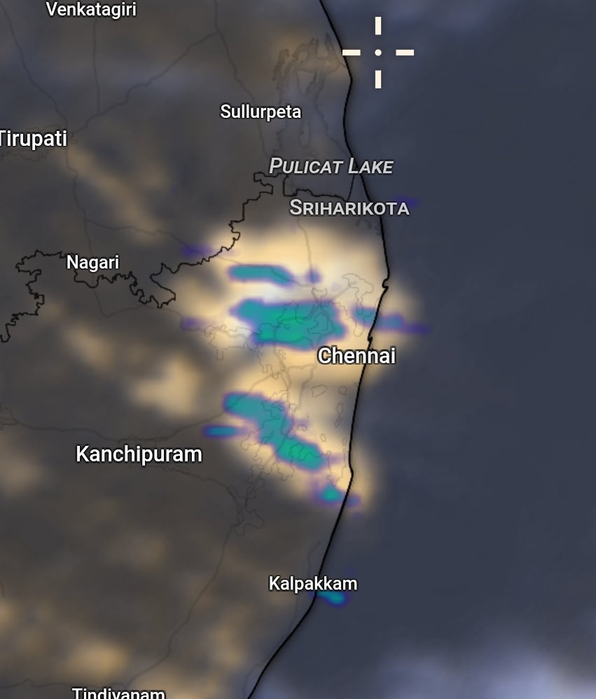
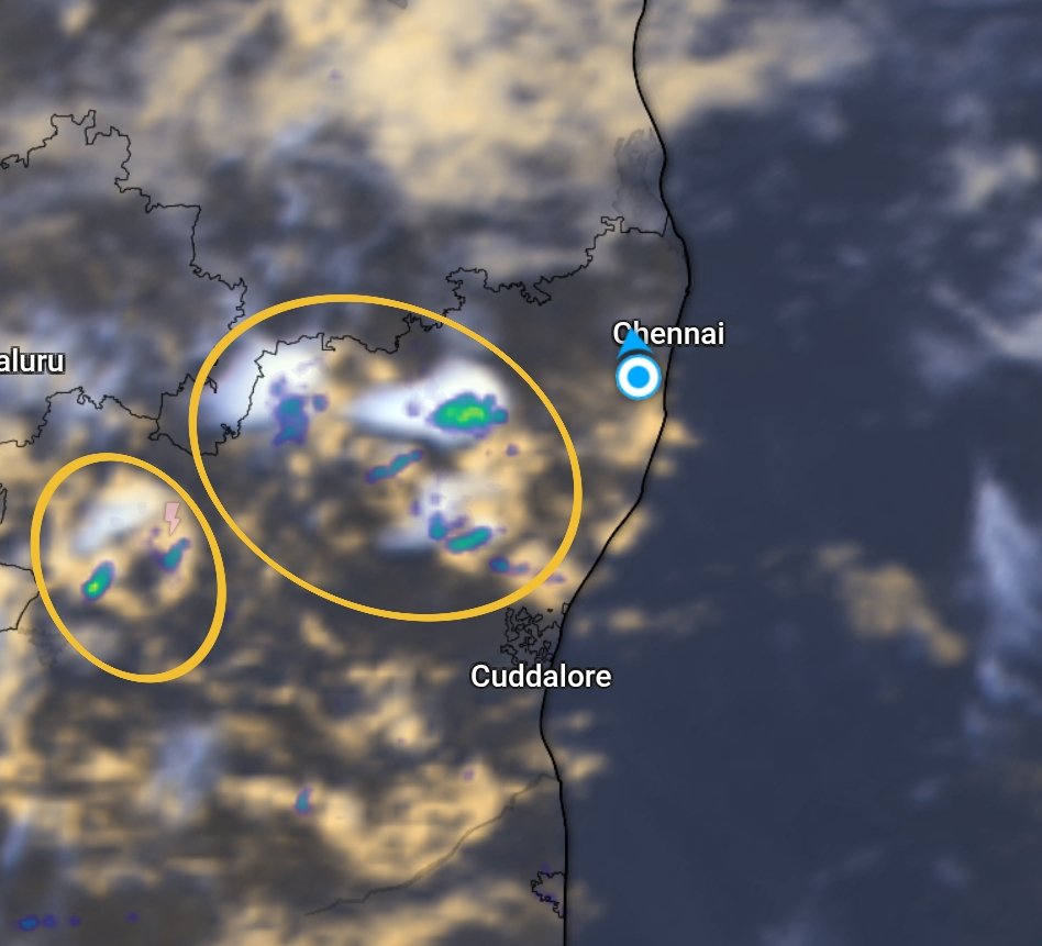
⛈️One more chance of rain or thundershowers today for chennai and chengalpattu districts!
Post sunset, surface convergence and low level confluence setting in towards west of Chennai city. This shall bring one more light spell of rain in next couple of hours over Chennai and Chengalpattu districts. Further some showers possible in Tiruvallur and Kanchipuram district before 9 or 10 pm. This may not be big spell, only lighter one.

2
1
44
2,350
🌊The power of sea breeze convergence brings thunderstorm formation over Chennai, Tiruvallur and Chengalpet districts. This is very much localised development, cant expect in large!

3
51
1,473
Jun 15
15 Jun 2026: Ghats and Southern districts of Tamilnadu has good chance for thunderstorms today. The only consoling factor for Chennai is the sea breeze onset!
The trough at lower levels, surface convergence and vertical shear factors are favouring the plains of South Tamilnadu today. The westerly wind is slightly weakened and moisture has reduced to bring down rainfall intensity over the western ghat districts during the next 24 hours. Chennai and suburbs along with coastal belts to witness the sea breeze onset which is the only factor to console Chennaities today between 3-4 pm. This should bring down the thermal heat by evening and can lower the night temperature, importantly to below 30°C.
Moderate Rain:
🌧️🌧️Nilgiris, Coimbatore ghats, Dindigul districts during the next 24 hours.
⛈️⛈️Moderate thundershowers likely over Madurai, Virudhunagar, Thoothukudi and Tirunelveli districts by evening or night.
⛈️Light rain with thundershowers at one or two paces likely over Coimbatore, Tiruppur, Erode, Thanjavur, Tiruvarur, Nagapattinam, Pudukottai, Ariyalur, Mayiladuthurai and Ramanathapuram districts by afternoon or evening.
1
1
19
1,042
Jun 14
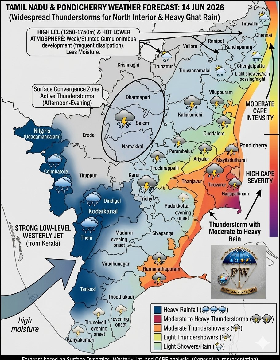
14 Jun 2026: Widespread thunderstorms to hit North Interior Tamilnadu and Heavy rain likely in ghats districts during the next 24 hours!
Surface Dynamics:
The surface convergence with high moisture indicates that active thunderstorm conditions to impact north interior tamilnadu today from afternoon to evening hours. Including Delta districts of Tamilnadu has good chance for rain with thunder and lightning. Few places over south interior tamilnadu too has chance for rain by evening.
Westerly Jet:
Strong low level westerly jet with high moisture from Kerala moving into western ghat districts of Tamilnadu may bring heavy rainfall during the next 12-24 hours.
Surface - Atmospheric Dynamics:
The convectively available potential energy (CAPE) is high along coastal areas of Tamilnadu. The severity is high from Pondicherry to Ramanathapuram coasts. Chennai to Pondicherry stretch with moderate intensity.
The lift condensation level over Tiruvallur, Tirupati, Kanchipuram areas is high beyond 1250 to 1750 meters. The heat from surface to 2 km altitude is hot. The warm air parcel rising above needs more vertical lift for condensation, hence formation of cumulonimbus would struggle or dissipate soon before maturing.
Chennai and Suburbs :
The lcl height towards west and northwest direction is weak, surface convergence from 3 pm approx due to sea breeze onset. However, the surface convergence creating less moisture over Chennai, Kanchipuram, Tiruvallur and Chengalpet districts. CAPE looking supportive.
Heavy Rainfall Forecast:
🌧️🌧️🌧️Nilgiris, Coimbatore ghats, Dindigul, Theni and Tenkasi districts.
⛈️⛈️Thunderstorms with moderate to heavy rain likely over Salem, Dharmapuri, Namakkal, Thiruchirapalli, Thanjavur, Tiruvarur, Ramanathapuram districts by afternoon or evening.
Light to Moderate Thundershower:
⛈️⛈️Moderate: Kallakuruchi, Villupuram, Perambalur, Ariyalur, Cuddalore and Mayiladuthurai districts.
⛈️Light Thundershowers: Pondicherry, Pudukottai, Madurai, Tirunelveli and Thoothukudi districts by evening.
🌦️Light showers or light rain possible in some areas over Chennai, Kanchipuram, Tiruvallur and Chengalpet districts by evening or night.


1
40
2,251
Jun 13
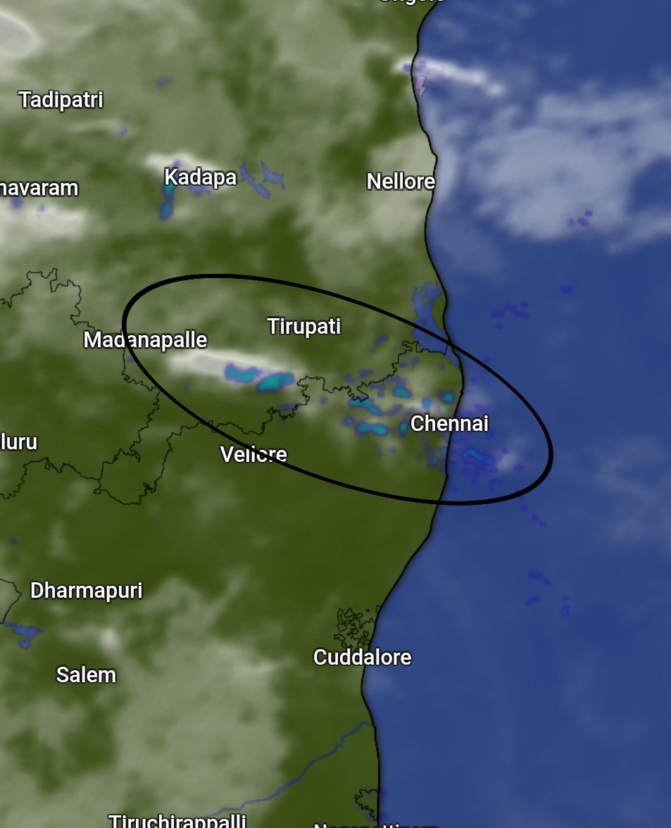
Thunderstorms formed over Vellore, Kanchipuram, Dharmapuri, Tindivanam and Tirupathur districts right now. Lets see in which direction it moves during next few hours!
40
1,460
Jun 13
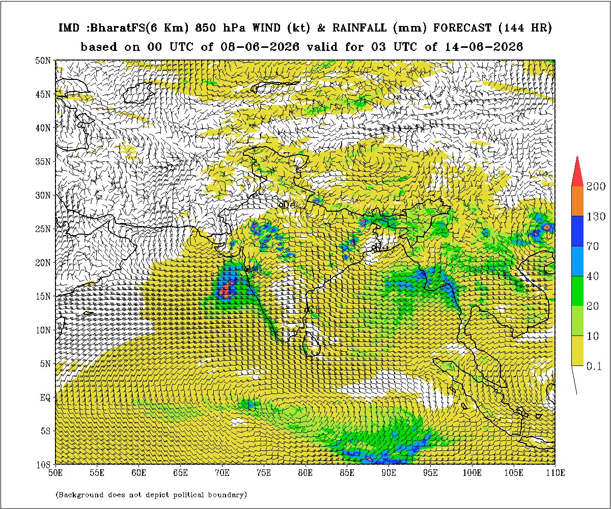
13 Jun 2026: Active Monsoon Conditions to Bring Widespread Heavy Spells; Isolated Very Heavy Rain Alert along Central and Northern Belts of Kerala and over South Coastal Karnataka.🌧️🌧️
South Peninsula Monsoon Update: Active Convective Dynamics Trigger Regional Thunderstorms
The Southwest Monsoon has advanced across major sections of the southern peninsula, setting up strong lower-tropospheric westerly winds and localized atmospheric cyclonic circulations that are driving widespread convective activity.
Statewise detailed forecast valud till 14 Jun 2026 morning : facebook.com/share/p/1CwX6nG…


3
65
4,233
Jun 11
Drive two wheeler from Porur to Vadapalani.
Jun 11

Driving in Chennai is a real experience; Google Maps gives directions, but only God gives confidence.
5
978
Jun 10

13
897
Jun 10
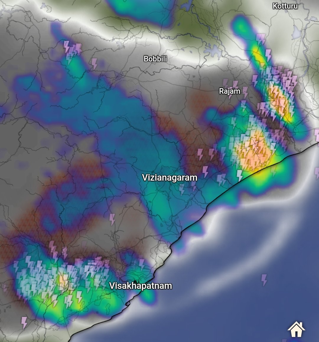
⛈️⛈️Severe thunderstorms over Anakapalli, Visakhapatnam, Vijayanagaram, Srikakulam districts now. Surface Convergence along the coast of North Andhrapradesh significantly producing these vulnerable thunder and lightning shows wit heavy rainfall. It is likely to sustain for another couple of hours!
2
32
2,058
Jun 10
Thunderstorms possible over North Tamilnadu from today evening to midnight. The low level confluence and mid shear zone to bring high instability.
Chennai, Chengalpet districts may receive thundershowers by evening or by mid night.
Tiruvallur, Kanchipuram, Vellore, Ranipet Krishnagiri and Tirupattur districts has chance for moderate thundershowers by evening to night.
The intensity is likely to be moderate to heavy over these Interior Districts. Chennai and Chengalpet may receive light to moderate by evening or midnight.
4
4
63
3,012
Jun 10
10 Jun 2026: South Coastal and South Interior Karnataka, including Bengaluru has good chance for heavy rainfall and thunderstorms!
The westerly wind and off shore trough support to bring ample moisture towards South Coastal Karnataka during the next 24 hours. Heavy to very heavy rainfall likely over Dakshin Kannada, Udupi and Madikeri. Due to high shear, south interior karnataka has chance for widespread thunderstorms by afternoon or evening. Bengaluru, Tumakuru, Ramanagara, Mysuru, Mandya, Hassan districts has chance for moderate to heavy rainfall by afternoon or evening.
1
3
50
3,214
Jun 9
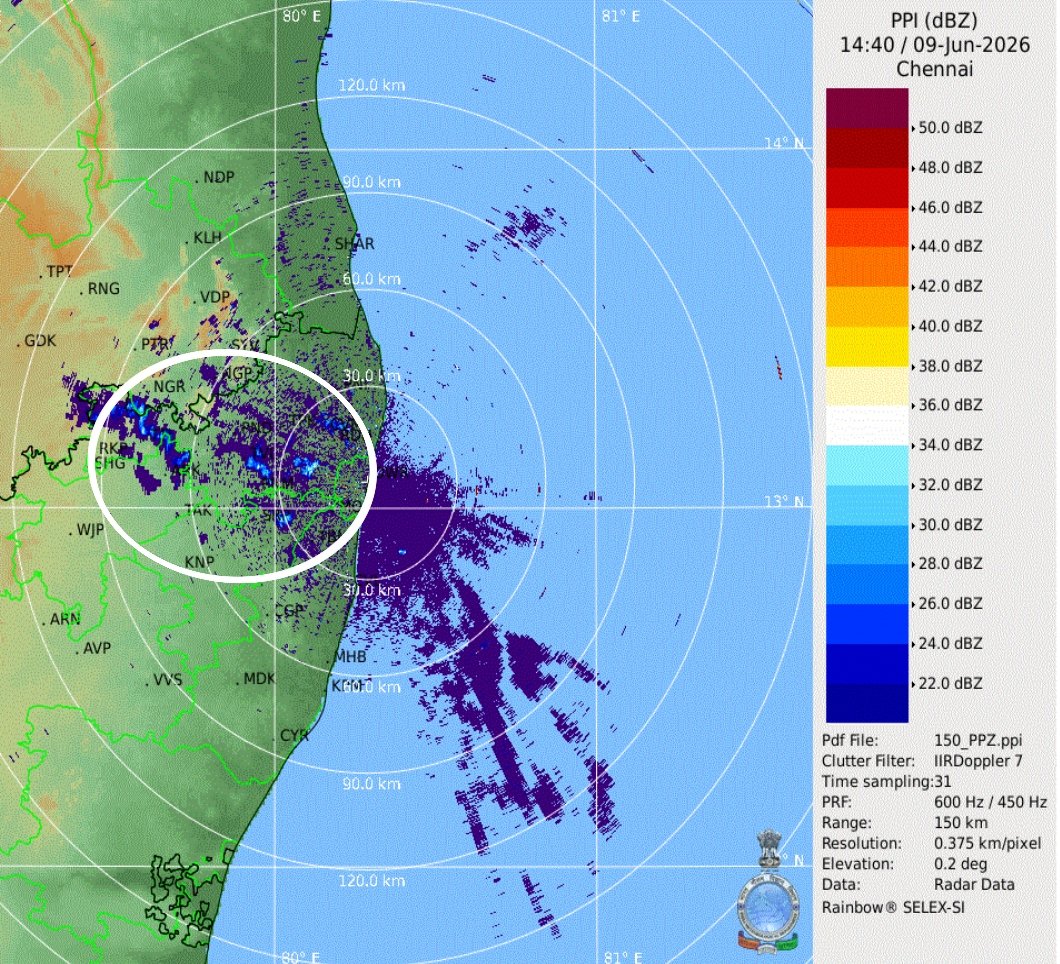
⛈️Weak thunderclouds forming towards west northwest direction from chennai. It may bring light showers in one or two places in ktcc districts!
Raining now in east tambaram areas!!
1
32
1,028
Jun 9
⛈️This was the expected rains since morning. Surface Convergence and Trough at low to mid levels support for #hyderabadrains


3
3
32
3,501
Jun 9
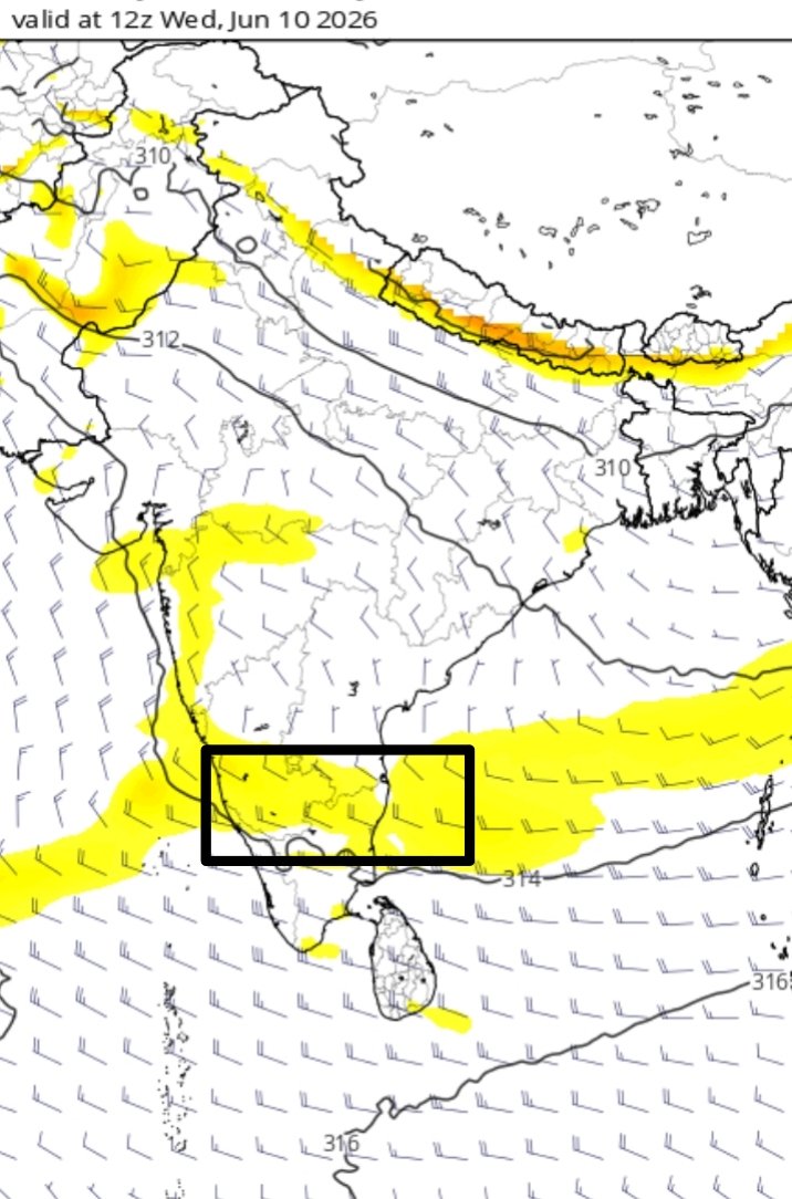
⛈️Good News for Chennai and Suburbs: Between 10th and 13th June, dynamics looking bright for TS!
The atmospheric charts point toward a very strong likelihood of the first major Southwest Monsoon (SWM) 2026 thunderstorm window opening up for Chennai and its suburban areas anyday between Today (9 Jun 2026) and Friday (12 Jun 2026).
1. Thermodynamic Instability (CAPE)
Analysis: The ECMWF Surface CAPE chart shows moderately healthy instabilty values building along the north coastal and leeward plains of Tamil Nadu (within the highlighted white box). More importantly, the adjacent offshore waters in the Bay of Bengal are exhibiting massive energy reservoirs exceeding 3000 to 4000 J/kg (represented by the deep red and purple gradients in the image). This proximity ensures that any sea-breeze front or boundary layer interaction can rapidly tap into highly unstable air.
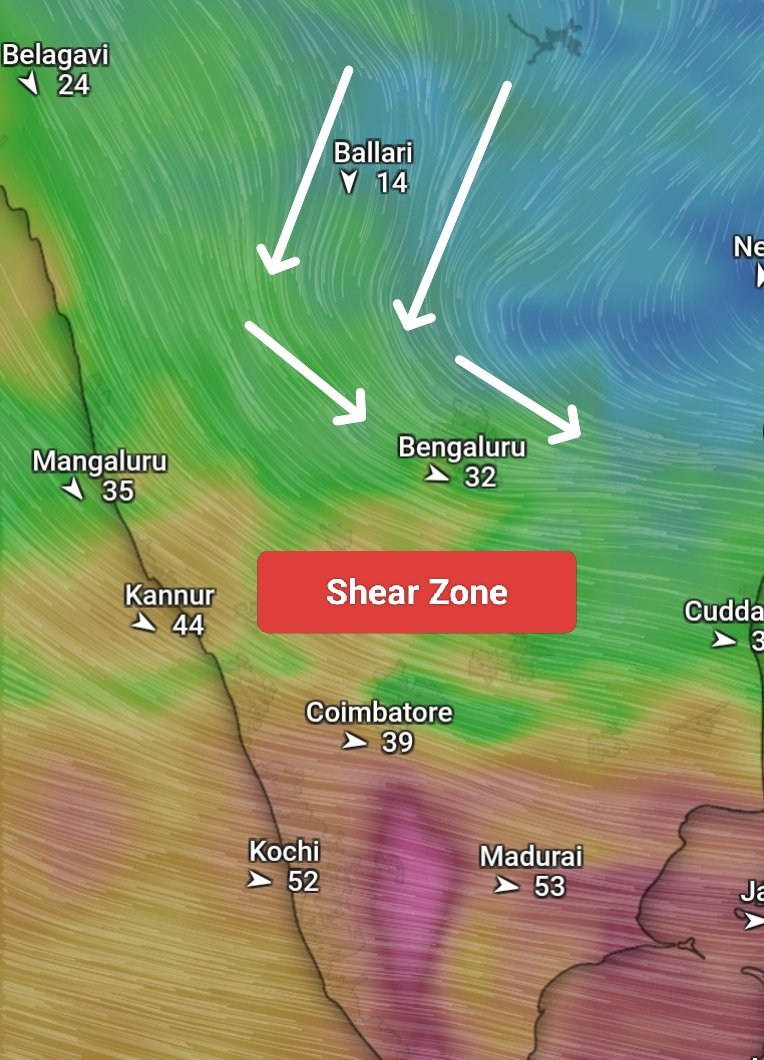
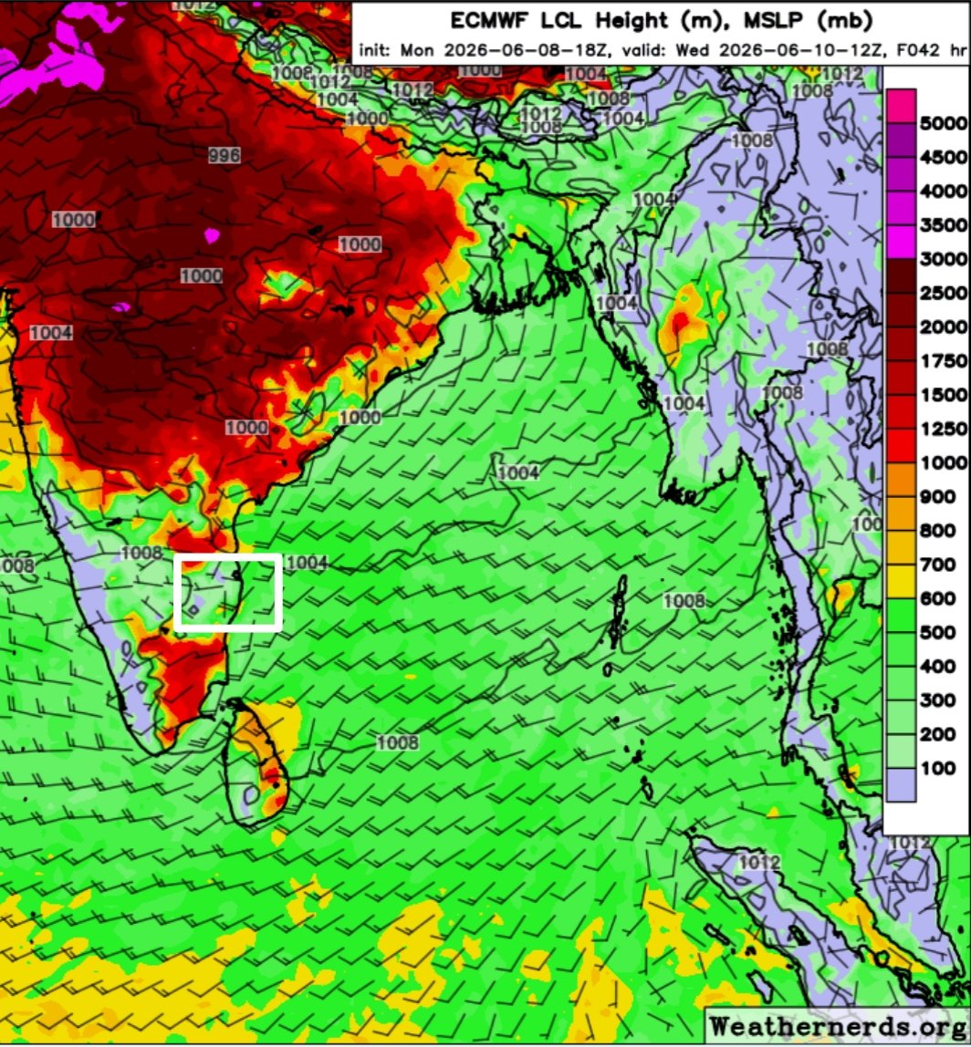
2. Moisture Availability & Cloud Base Dynamics (LCL Height):
Analysis: The Lifted Condensation Level (LCL) height chart marks the Chennai region with relatively low cloud bases—hovering around 500 to 700 meters on 10th June 2026 (indicated by the bright green hues). We saw the same LCL height was 1250 and above yesterday (8 Jun 2026). Low LCL heights point to robust low-level moisture tracking across the peninsula, allowing convective updrafts to condense easily without having to overcome excessively dry lower layers.
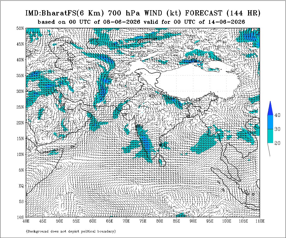
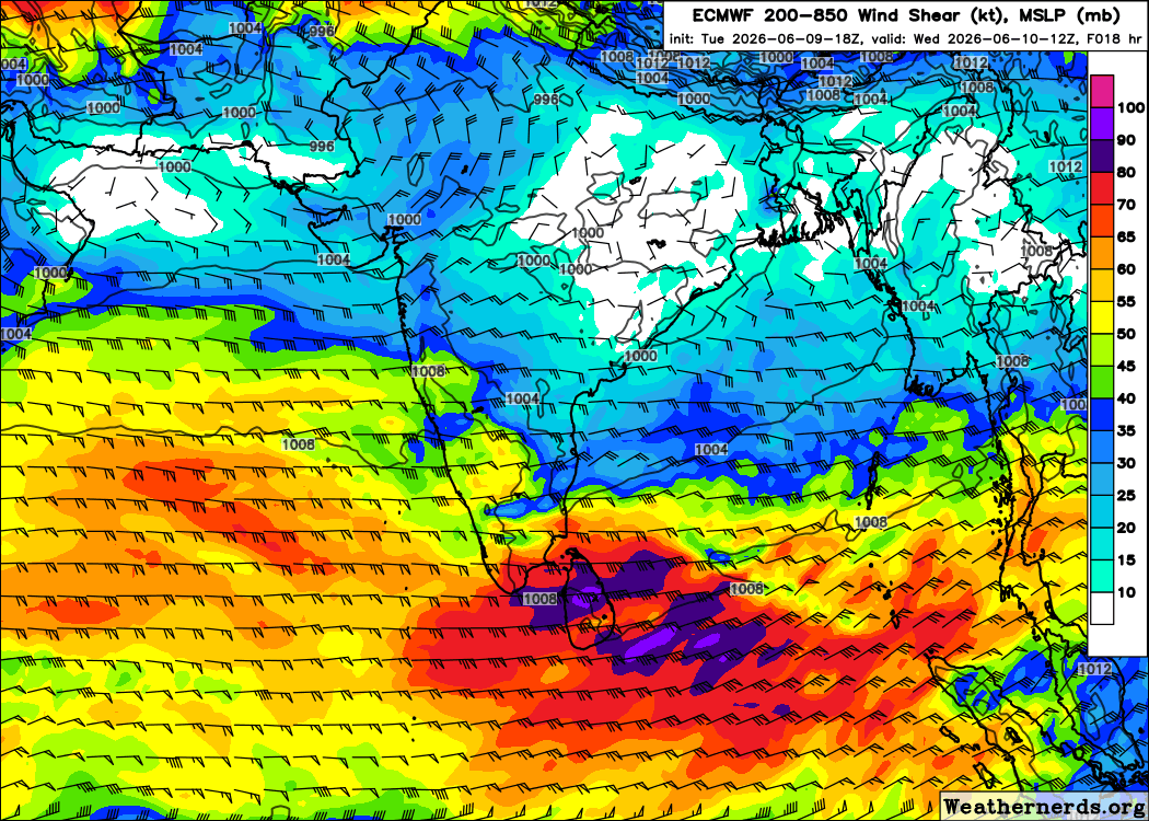
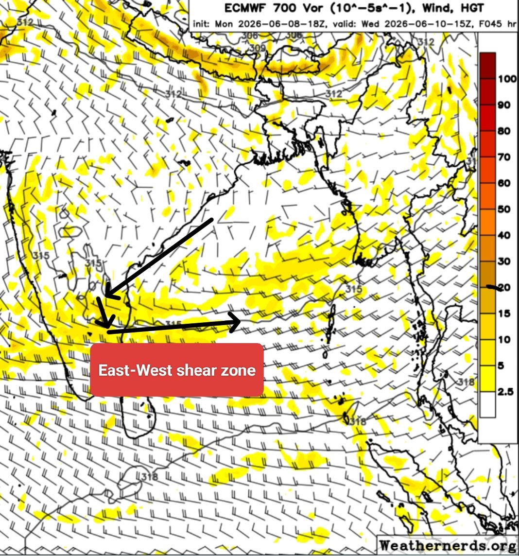
3. Dynamic Support (700 hPa Vorticity & Shear Zone):
Analysis: The key driver for this spell is the prominent East-West shear zone running straight across the southern peninsula at the 700 hPa level (3-5.5 km altitude). As noted by the directional arrows, the convergence of stiff westerly monsoonal winds interacting with drier northern air creates a classic zone of cyclonic vorticity (the yellow pockets).
What to Expect for Chennai & Suburbs from 10th to 12th June?
High Probability Window: From this evening (Tuesday 50-50 chance) through Friday, June 12th. Global models consistently underestimate the initial convective triggers of the season, meaning widespread, intense spells are very much possible despite conservative baseline model rain totals. Especially on 10th and 11th June or before 13th June the conditions looking good for first spell of rain in Chennai, Chengalpet, Kanchipuram, Tiruvallur, Villupuram, Pondicherry, Cuddalore and Mayiladuthurai districts. Today the 9th June, I am not confident or sure about the developments, hence could not forecast anything for tghe day.
The Routine: Expect intense afternoon heat to peak late as strong westerlies delay or weaken the incoming sea breeze. However, the shear-zone-driven wind convergence will act as the perfect trigger to spark sudden, sharp thunderstorm roll-ins during late evenings or nights, bringing much-needed relief from the soaring nighttime temperatures.
9
5
85
5,232
Jun 9
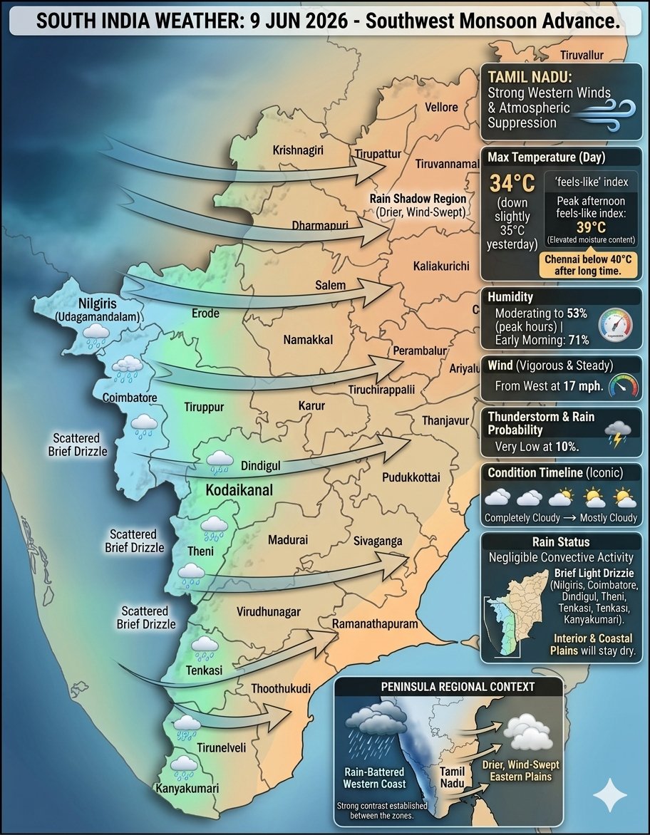
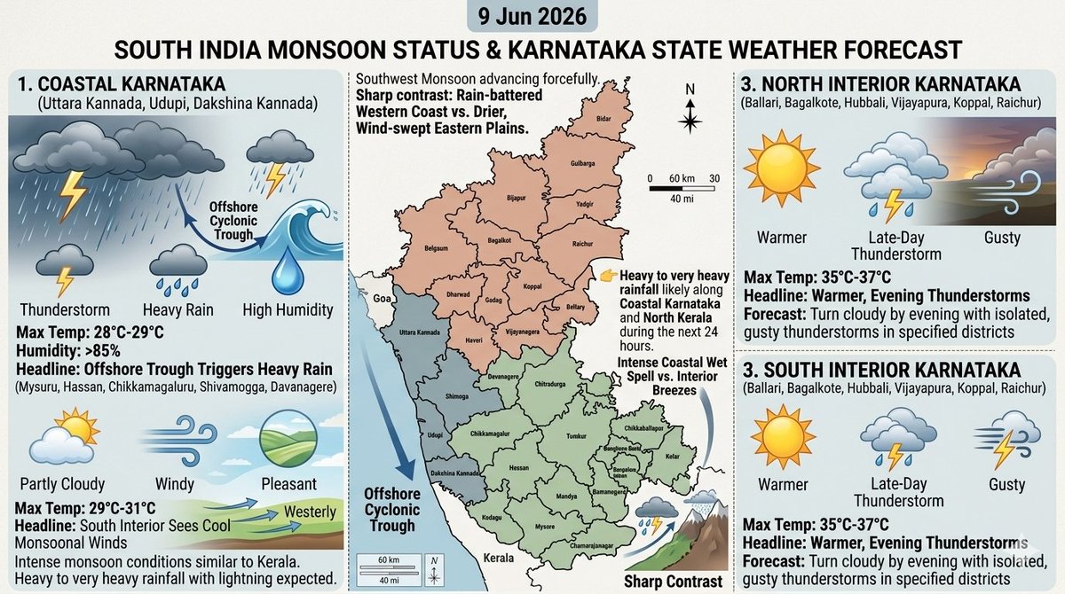
9 Jun 2026: The Southwest Monsoon is advancing forcefully across the southern peninsula, establishing a sharp contrast between the rain-battered western coast and the drier, wind-swept eastern plains.
Key Points:
👉🏻Heavy to very heavy rainfall likely along Coastal Karnataka and North Kerala during the next 24 hours.
👉🏻Moderate to heavy over remaining parts of Kerala.
👉🏻Widespread thunderstorms likely over South Telangana. Hyderabad city in for moderate to heavy thundershowers.
👉🏻Day temperature is likely to drop by 1-2°C in Tamilnadu. Chennai to record below 40°C after long time.
Statewise forecast briefing: facebook.com/share/p/1VFxaG5…

1
39
2,468