
Welcome to the City of Plano Department of Emergency Management page. Report emergencies to 911. Terms: share.plano.gov/Terms
- Tweets 8,537
- Following 671
- Followers 13,851
- Likes 12,673


ALT A smiling man with glasses and a gray polo shirt waves a white cloth in his hand, standing next to a tall object. The object, decorated to resemble a cartoon character, wears a hockey helmet and a Dallas Stars jersey. A sign in the background reads "Plano EM Emergency Management," with a logo.
ALT Cartoon of a smiling siren tower with googly eyes and a speech bubble saying, "Waily says... Don’t be alarmed, it’s just my song, At noon I wail, it won’t last long." Two illustrated birds and a sun are nearby; "Siren Test Today" and a City of Plano Emergency Management logo are on top.
ALT A group of seven people stand in a line indoors, smiling at the camera. They are in front of a modern art installation composed of numerous hanging hats of various colors. An escalator with a person descending is visible in the background. The setting seems to be a spacious, well-lit building.
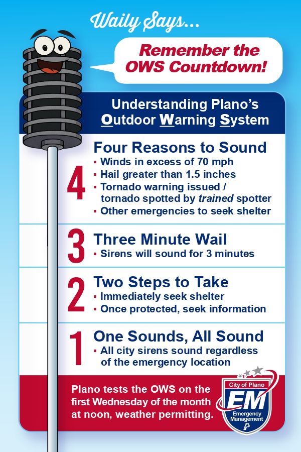
ALT Alt text: An infographic titled "Remember the OWS Countdown!" features "Waily," a cartoon outdoor warning siren with eyes and a mouth. It explains Plano’s warning system: 4 reasons to sound (high winds, large hail, tornado warnings, or other emergencies), a 3-minute wail, and 2 steps (seek shelter and information). All sirens sound regardless of location. Testing is on the first Wednesday monthly at noon, weather permitting. Includes the City of Plano Emergency Management logo.
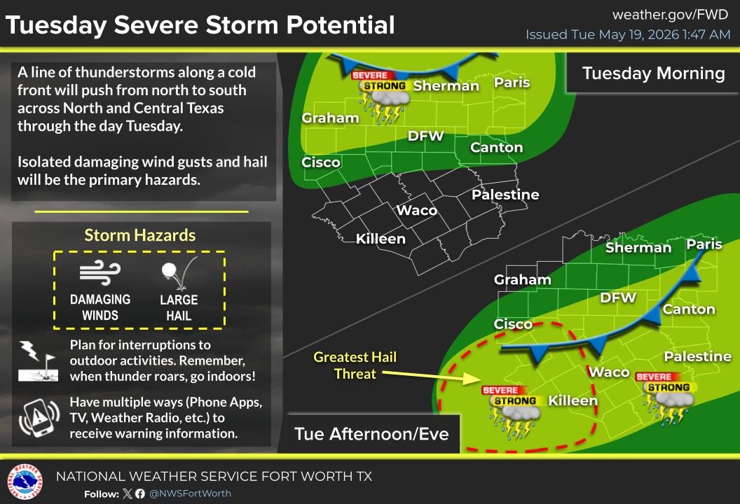
ALT Map showing Tuesday's severe storm potential in North and Central Texas. Two areas, one in the morning for Sherman to Paris, and a larger one in the afternoon covering Cisco to Killeen, marked for severe storms with damaging winds and large hail. Key cities like DFW and Waco are highlighted. Storm hazards are detailed with icons, and safety advice is provided.
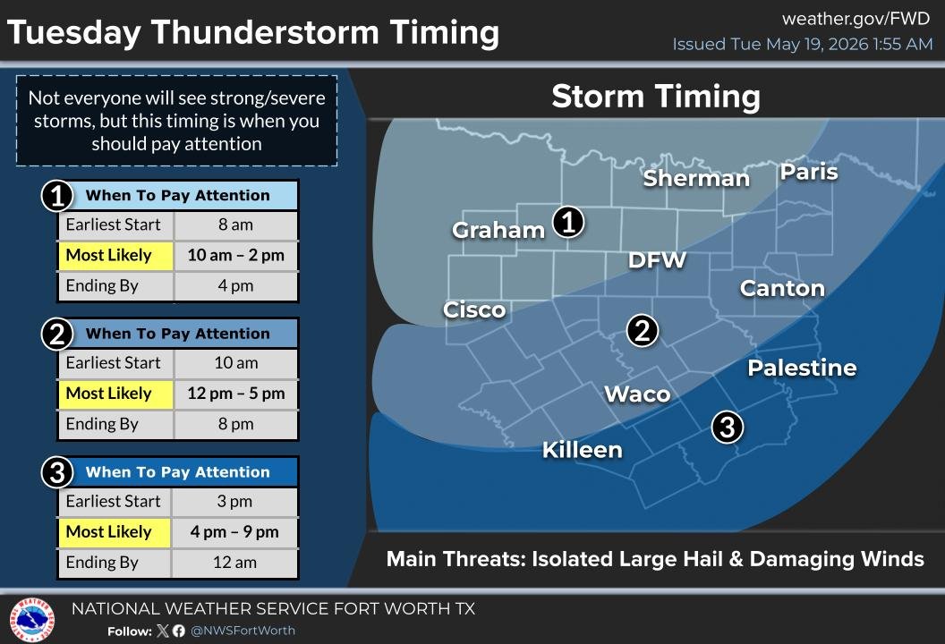
ALT Map showing Tuesday thunderstorm timing for regions around Fort Worth, Texas. Three zones indicate storm likelihood periods: Zone 1 (Graham to DFW) from 10 AM to 2 PM, Zone 2 (Cisco to Waco) from 12 PM to 5 PM, and Zone 3 (Killeen to Palestine) from 4 PM to 9 PM. Main threats include isolated large hail and damaging winds.
ALT Join Plano's Community Emergency Response Team (CERT) flyer. The left side features white text on a green background encouraging community involvement and training in disaster response, first aid, CPR, fire safety, and search and rescue. The right side shows images of people wearing green CERT vests engaged in a training exercise. The City of Plano CERT logo is visible at the bottom right, and the website for more information is provided.

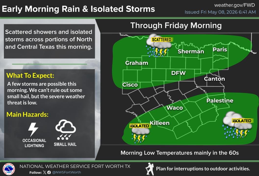
ALT Alt text: Weather forecast graphic titled "Early Morning Rain & Isolated Storms" for North and Central Texas, issued May 8, 2026. It highlights scattered showers and isolated storms through Friday morning. A map shows affected areas, including Graham, DFW, Sherman, and Killeen. Hazards noted are occasional lightning and small hail, with low severe weather threat. Temperatures in the 60s. National Weather Service Fort Worth logo included.
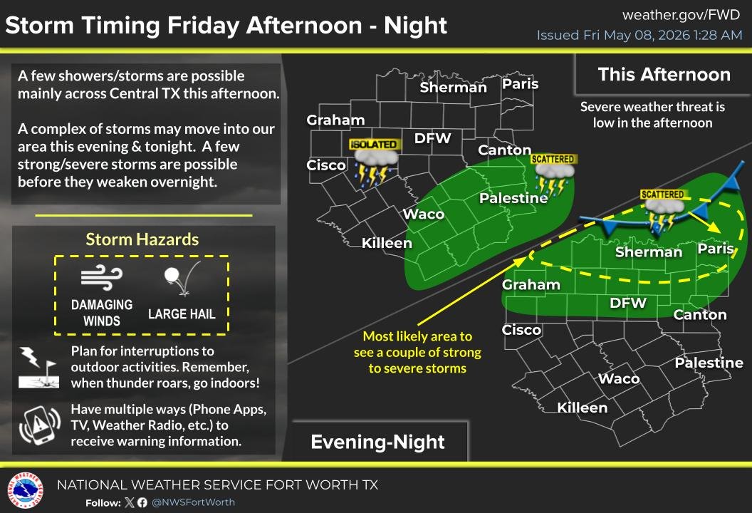
ALT Storm timing infographic for Central Texas issued on May 8, 2026, shows potential for showers and storms. Afternoon has low severe threat, while evening and night have higher risk with scattered and isolated storms marked in green areas on map. Key regions like Sherman, Paris, and DFW highlighted. Alerts for damaging winds and large hail. Advises preparedness for outdoor activities and multiple info sources. National Weather Service branding included.
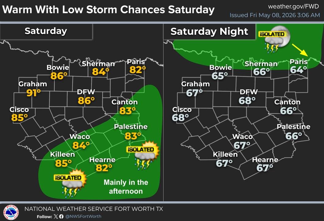
ALT Weather forecast map for North Texas. Saturday is warm with high temperatures ranging from 82°F in Paris to 91°F in Graham. Isolated thunderstorms mainly in the afternoon in southern areas including Killeen, Hearne, and Palestine, marked with green shading. Saturday night shows cooler temperatures, with lows from 64°F in Paris to 68°F in DFW. Isolated storms expected in the Paris area, highlighted with green and an icon.
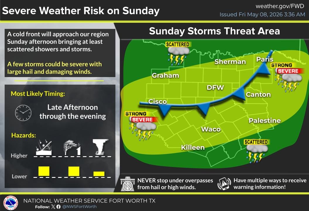
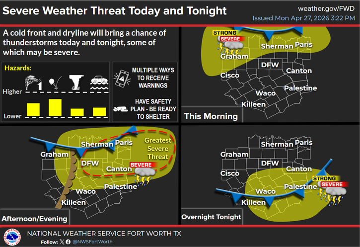
ALT The image is a weather alert infographic from the National Weather Service Fort Worth, outlining a severe weather risk on Sunday. It highlights that a cold front will bring scattered showers and storms, with potential for large hail and damaging winds. The most likely timing is from the late afternoon through the evening. A map displays an area marked in yellow, indicating the threat level, with labels for cities like Sherman, Graham, DFW, Canton, and Paris. Symbols illustrate the severity, including strong and severe storms. Safety reminders advise against stopping under overpasses and suggest having multiple ways to receive warnings.
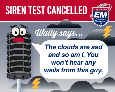
ALT A cartoon of a worried siren pole named "Waily" is against a cloudy background with lightning, announcing the cancellation of a siren test. The siren has wide eyes and a frown, with a speech bubble saying, "The clouds are sad and so am I. You won’t hear any wails from this guy." The top banner reads "Siren Test Cancelled," and there's a City of Plano Emergency Management logo in the corner.
ALT A small, robed figure with green ears and a glowing green lightsaber stands in a futuristic corridor. The text "Use the Forecast" is displayed prominently in bold, yellow letters. Surrounding the text are weather icons, including sun, clouds, rain, snowflakes, and wind. The logo for "City of Plano EM Emergency Management" is at the bottom right.
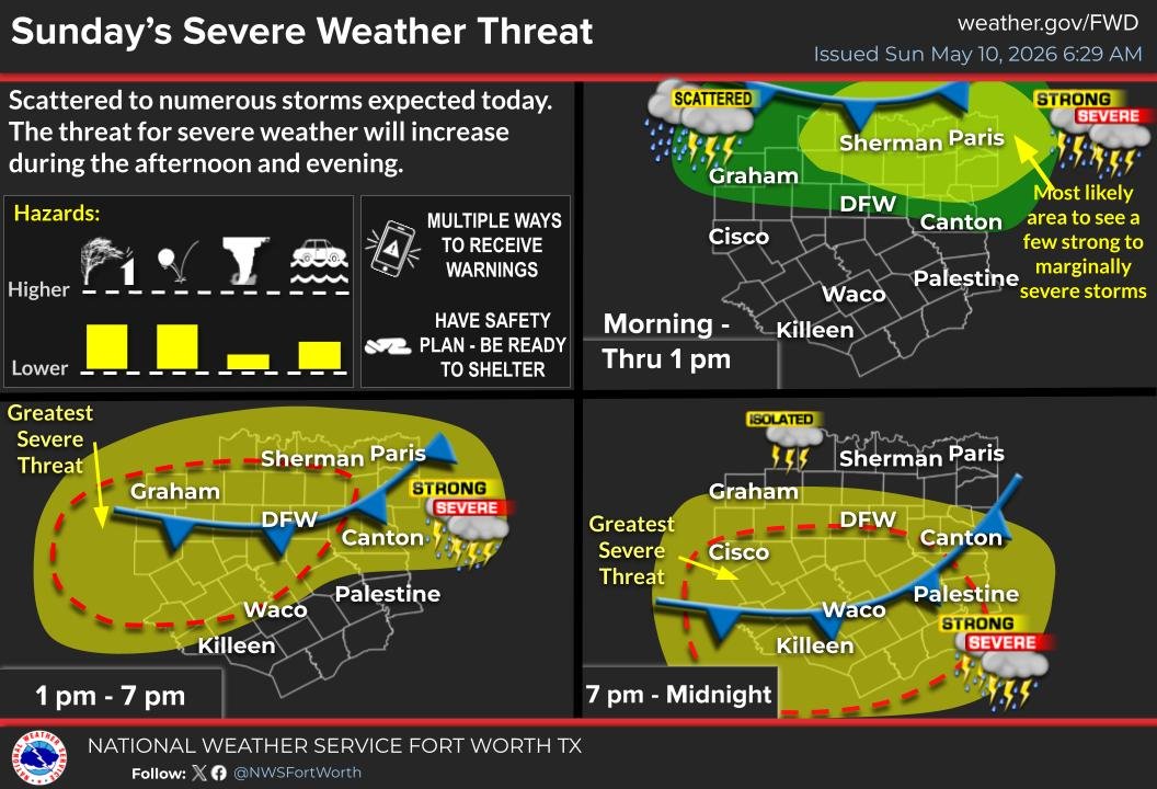
ALT Severe weather alert graphic from the National Weather Service Fort Worth, TX, showing maps of North Texas with highlighted areas indicating threat levels for thunderstorms. The central panel warns of "Greatest Severe Threat" around Sherman, Paris, DFW, and Canton, marked in red. Other panels show "Strong to Severe" threats in yellow areas, shifting throughout the day and night. Text advises having safety plans and multiple ways to receive warnings. Expected hazards include thunderstorms, lightning, hail, and strong winds.
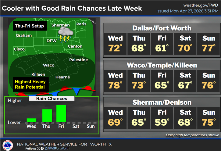
ALT A weather forecast graphic for late week showing cooler temperatures and good rain chances in Texas. A map highlights an area with the highest heavy rain potential. It indicates temperatures for cities including Dallas/Fort Worth (Wed 72°F, Thu 68°F, Fri 61°F, Sat 70°F, Sun 77°F), Waco/Temple/Killeen, and Sherman/Denison. A bar graph below shows increasing rain chances from Wednesday to Friday, peaking on Saturday. The graphic mentions thunderstorms and indicates possible severe weather in north-central Texas.
ALT Image titled "Watch vs. Warning" compares a "Watch" and a "Warning" using grilled cheese as a metaphor. The top half labeled "Watch" shows bread, cheese, and butter, with text urging preparedness. The bottom half labeled "Warning" depicts a ready-made grilled cheese sandwich, emphasizing immediate action. The City's emergency management logo is included.
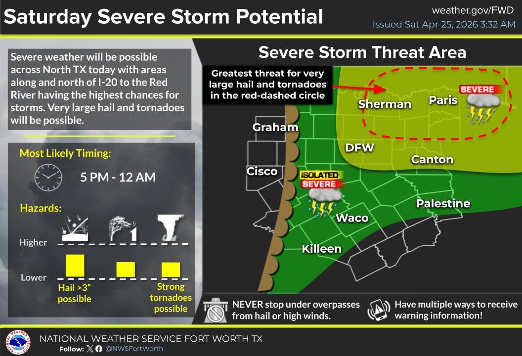
ALT A weather alert graphic titled "Saturday Severe Storm Potential" details severe weather predictions for North Texas. The text indicates a high chance of very large hail and tornadoes, especially north of I-20 to the Red River. The most likely timing is 5 PM to 12 AM. A map shows a highlighted area with a red dashed circle around Sherman and Paris, labeled as having the greatest threat. Icons denote "Severe" and "Isolated Severe" storm potential in various areas. Warnings include hail over 3 inches and strong tornadoes. Safety tips advise against stopping under overpasses and recommend multiple ways to receive warnings.
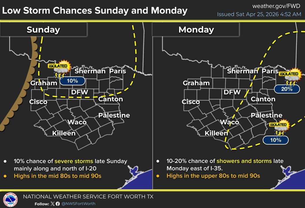
ALT Map shows storm forecasts for Sunday and Monday in Texas. Sunday: 10% chance of isolated storms north of I-20, with highs in the mid 80s to 90s. Monday: 10-20% chance of showers east of I-35, with highs in upper 80s to mid 90s. Yellow dashed lines indicate storm areas. Locations like DFW, Sherman, and Paris are marked.

ALT A football game at night under a stormy sky with visible lightning. Players and coaches are gathered, looking towards the field. Large text reads: "Kids be like... 'Is it safe to play now?'" The City of Plano Emergency Management logo is in the bottom right corner.
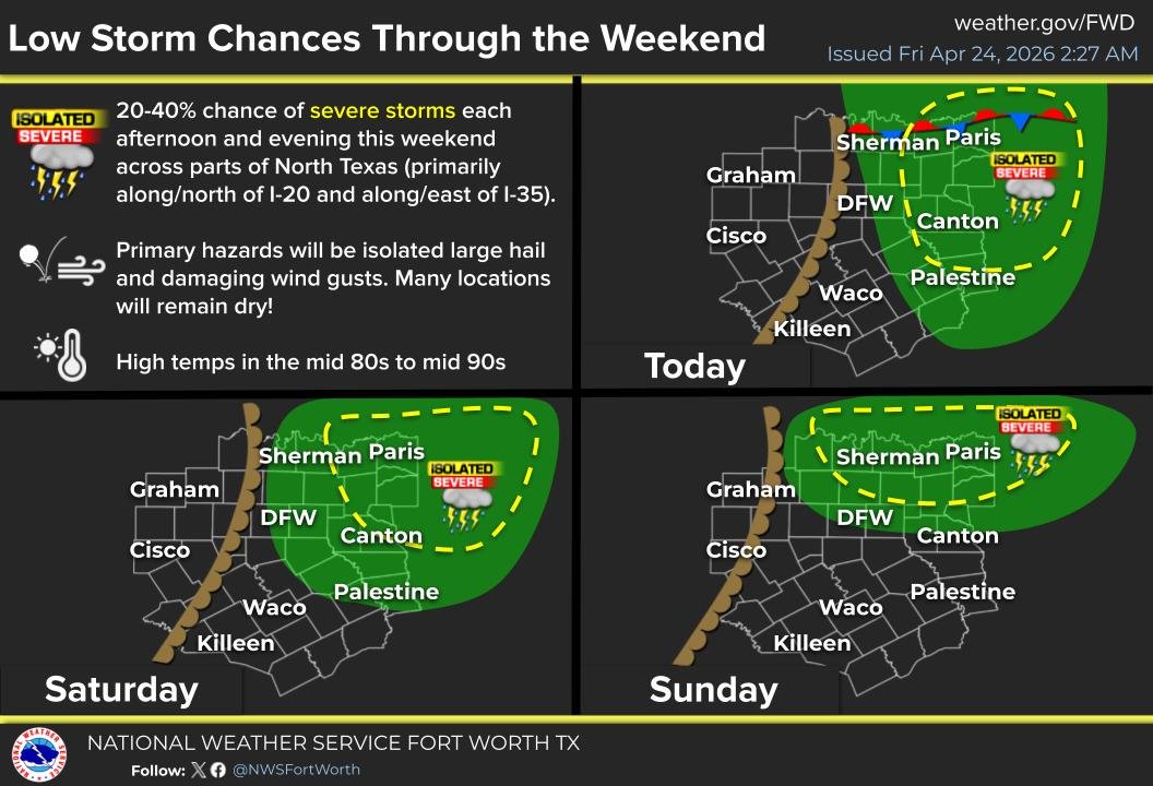
ALT The image is a weather forecast from the National Weather Service Fort Worth, TX, highlighting low storm chances through the weekend, issued on April 24, 2026. It shows a 20-40% chance of severe storms in parts of North Texas, specifically north of I-20 and east of I-35. Hazards mentioned include isolated large hail and damaging wind gusts. High temperatures are anticipated in the mid-80s to mid-90s. The forecast graphics for Friday, Saturday, and Sunday illustrate areas with severe storm potential marked in green and yellow, covering locations including Sherman, Paris, DFW, and Canton.


ALT A group of people outdoors, working together to lift a heavy weight using long metal rods and wooden pallets. They are dressed in casual clothing with some wearing gloves. A brick wall and grass are visible in the background.

ALT Four people are participating in a flood simulation exercise near a curbside storm drain. They are setting up a wooden ramp with hoses across the drain. Two individuals are kneeling on the grass, while two others stand and observe. Behind them is a wet sidewalk, red trailer, and emergency equipment.
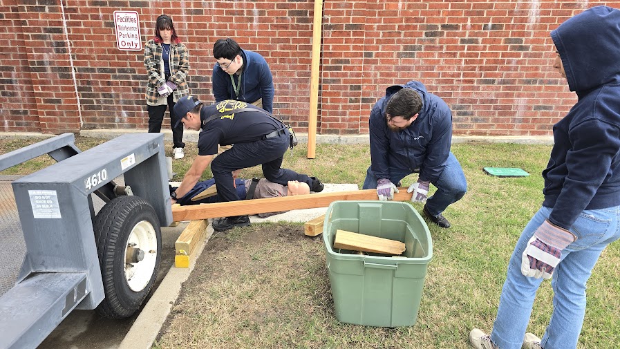
ALT A group of people are gathered around a mechanical trailer with blocks of wood. One person is kneeling and reaching under the trailer, while another assists by holding a piece of wood. A large green bin containing more wood pieces is nearby. The scene is outdoors on grass, next to a brick wall with a "Facilities Maintenance Parking Only" sign. Some individuals are wearing gloves and jackets, suggesting cool weather.

ALT A group of people are practicing CPR on mannequins in a classroom setting. Several individuals are kneeling on the carpeted floor, focused on performing chest compressions. A man stands nearby, observing and providing guidance. Chairs and a projector screen with text are in the background.