
Father, meteorologist, optimist.
Joined June 2010
- Tweets 16,231
- Following 1,521
- Followers 8,427
- Likes 10,157
1,307 Photos and videos


Russ Lacate retweeted

25 Jul 2024
⚠️ Jasper Complex Wildfire Update: Current as of 1638 ⚠️
19
282
989
373,595
Russ Lacate retweeted
25 Jul 2024
⚠️⚠️ Jasper Complex Wildfire ⚠️⚠️
Current as of: July 24, 7:10 pm, Mountain Time
---
Around 6:40 pm this evening, wildfire reached the Jasper townsite.
112
618
1,443
802,227
Russ Lacate retweeted
25 Jul 2024
⚠️⚠️ Jasper Complex Wildfire ⚠️⚠️
Current as of: July 24, 1800h, Mountain Time
At just before 6 pm this evening, portions of the South Fire in Jasper National park reached the outskirts of the Jasper townsite after being driven by strong winds gusts from the south and southeast.
55
451
1,144
402,160

24 Jul 2024
I’m back in the lab this week @CBCVancouver . Stories were following: keeping track of the changing #wildfire situation in the BC Interior, plus your @celeboflight forecast for tonight’s fireworks at English Bay.
3
55
2,700
Russ Lacate retweeted

17 Jan 2024
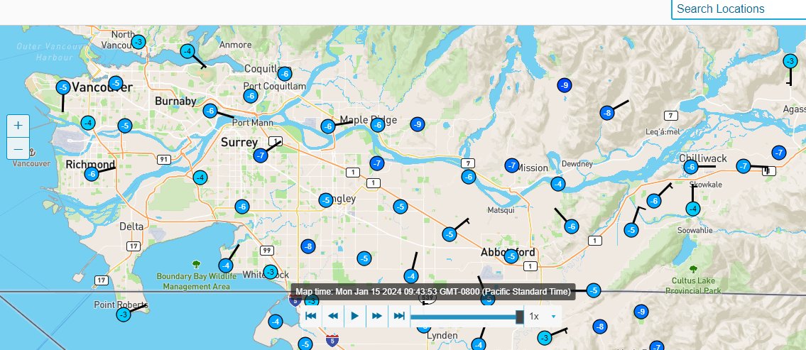
Some rough METAR math and a few observations but feel free to contribute your snowfall totals in this thread. #BCSnow
47
16
86
19,904
17 Jan 2024
5/ Something to keep an eye on: Inland routes east of Metro #Vancouver & through the #FraserValley may experience a prolonged spell of #freezing rain lasting throughout Thursday night and into Friday morning, but this does NOT apply to coastal areas. #bcstorm
1
2
18
4,514
17 Jan 2024
4/ As precipitation redevelops late Thursday, it may be a mix of #snow, rain & #freezing rain for several hours Thursday evening, before the #arctic air is finally flushed away during the night. All precipitation changes over to rain as temps rise to 2 ahead of sunrise Friday.
1
3
21
4,161
17 Jan 2024
3/ It may turn out to be about a 24-hour period (3pm Wed to 3pm Thu) of dry and cold conditions across Metro #Vancouver, before precipitation redevelops late Thursday afternoon. We are not quite out of the woods yet. #bcstorm
1
3
36
7,908
17 Jan 2024
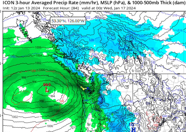
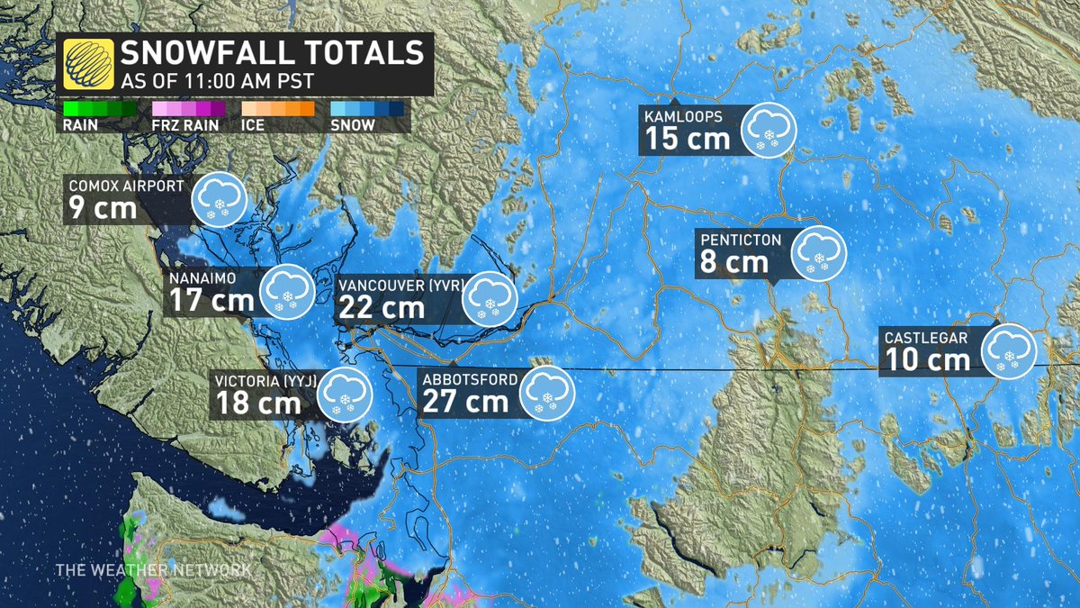
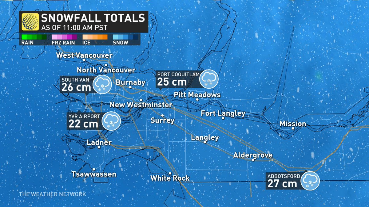
1/ #Bcstorm weather update midday Wednesday: Reported accumulations of 15 to 25 cm across
Metro #Vancouver so far, with another 5 cm to come, as snowfall becomes lighter and intermittent early this afternoon, then ends near 3pm.
1
3
27
5,285
16 Jan 2024
5/ Finally the last of these scraps of trapped #arctic air will be flushed away Thursday night, as all precipitation across Metro #Vancouver changes phases to #rain later Thursday night and into Friday morning. Back to 'normal' weather (milder & wet) this weekend. #bcstorm
2
2
38
8,322
16 Jan 2024
3/ #Snow continues to accumulate Wednesday, with another 10 cm in the morning, then 2 to 5 cm in the afternoon. This is almost exclusively a snow event, as temperatures remain near zero all day across Metro #Vancouver. Snow ends and the pattern dries out by sunset Wednesday.
2
31
7,618
16 Jan 2024
2/ Only a little patchy #freezing rain mixes in late overnight and through daybreak Wednesday, as much of the warmer air aloft gets pinched off to the south and into Washington State by the Pacific jetstream.
2
18
4,052
16 Jan 2024
1/ Forecast fine-tuning: Remaining dry under an increasingly cloudy sky today and this evening, followed by the first few #snowflakes arriving close to 10:00 pm. Overnight accumulations 8 - 12 cm between midnight and sunrise Wednesday. #BCStorm
1
7
32
9,347
15 Jan 2024
4/ Due to the frozen ground, and the low-level outflow breeze ahead of the midweek #BCstorm it seems likely that snow on Tuesday night will succeed in sticking and accumulating even right down to sea level initially, setting the stage for a troublesome Wednesday morning commute.
1
28
6,367
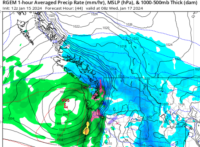
15 Jan 2024
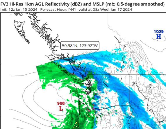
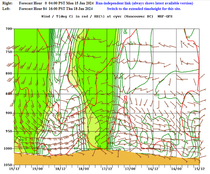
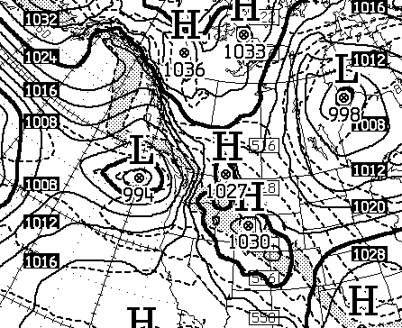
2/ Model outputs continue to disagree on the where the rain/snow boundary will lie, and how quickly the arctic air will retreat. Best estimate at this stage is for rapidly accumulating snow Tuesday night and Wednesday morning, at least initially. FV3-HiRes vs GEM Regional.
2
1
20
4,267
15 Jan 2024
1/ Winter Weather Update from 12z model run: Filtered sunshine with sub-zero temps today. Clouding over Tuesday as temp finally climbs above zero. Potential winter storm by midweek, as #snow begins Tuesday night leading into a slick Wednesday mix of snow, sleet and freezing rain.
1
22
3,680