
3,844 Photos and videos


Pinned Tweet

8 Nov 2021
Life update‼️

Ryan Shoptaugh, a native of San Antonio, will appear on KENS 5’s evening weekend newscasts as well as provide weather updates on KENS 5 digital channels. kens5.com/article/entertainm…
33
20
172
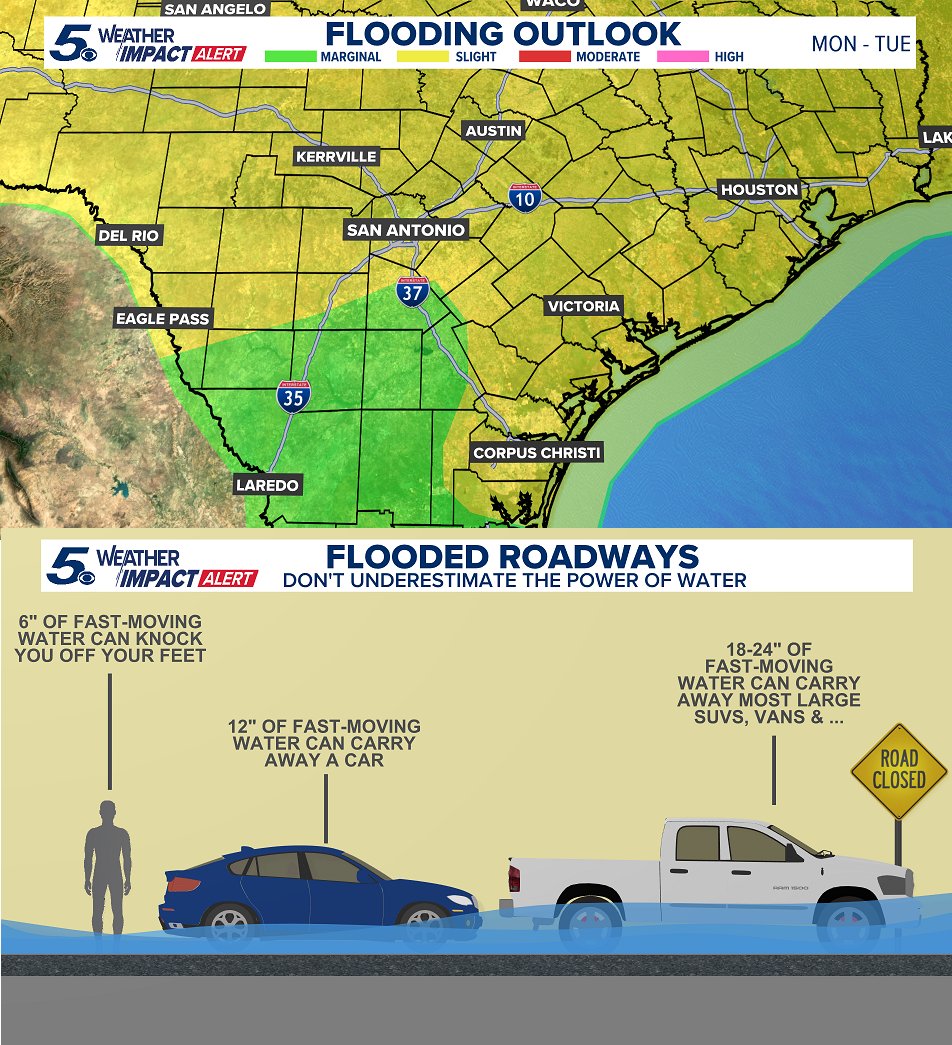
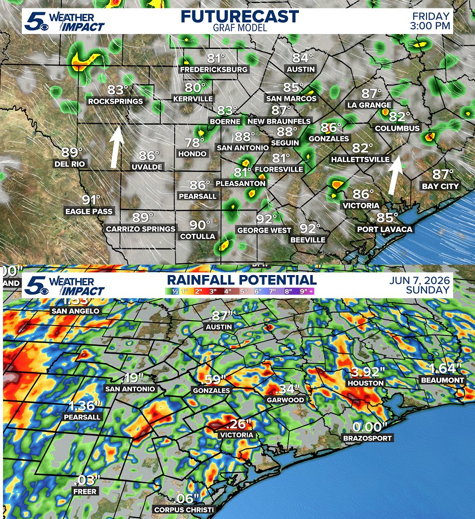
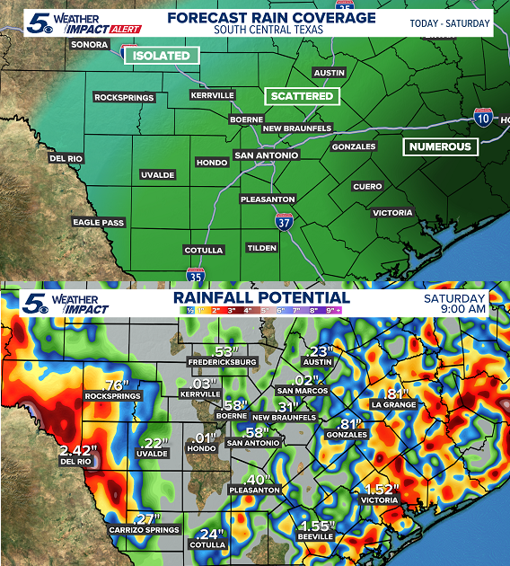
ELEVATED FLOOD POTENTIAL ⛈️ A Flood Watch is in effect for most of South and Southeast Texas until Tuesday. Downpours will be capable of very heavy rain! Keep in mind, this month marks one year since the Perrin Beitel floods in SA. High water can happen fast in summer. #txwx
2
3
651
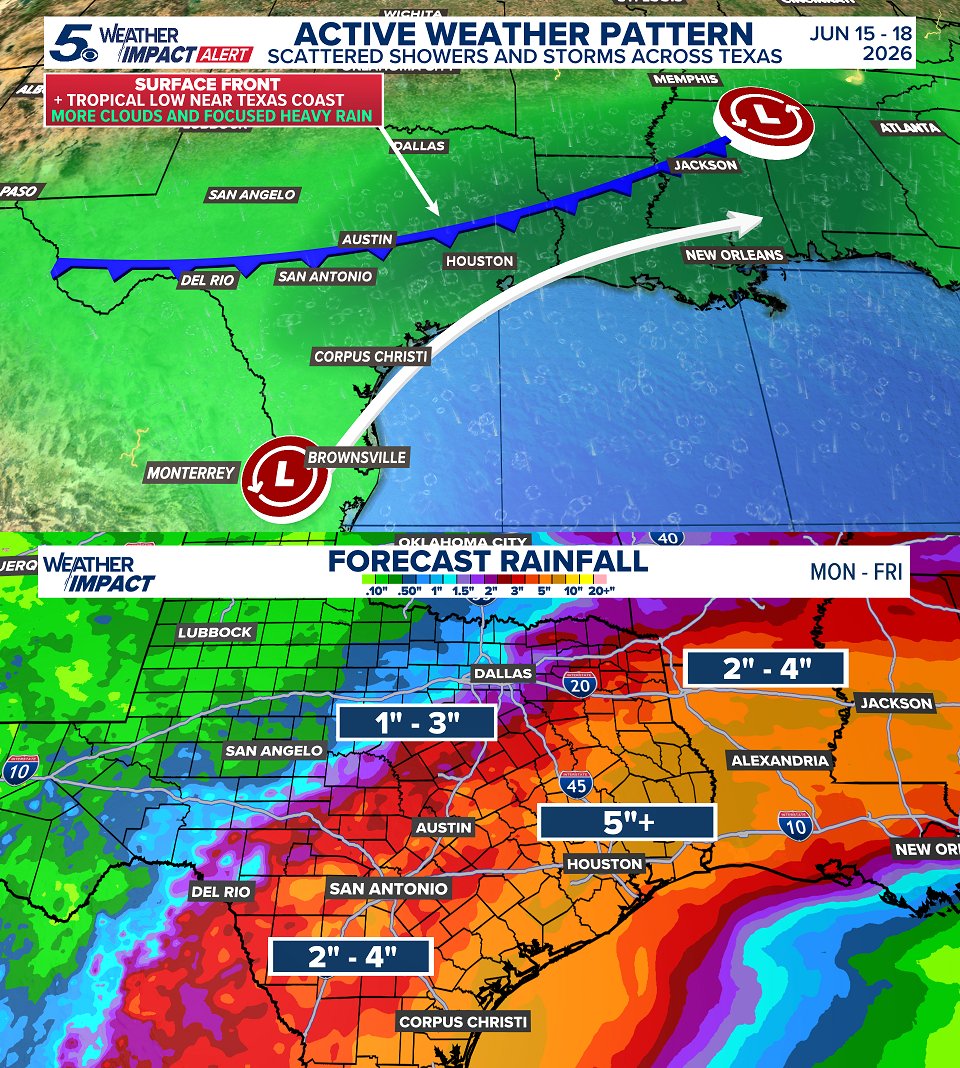
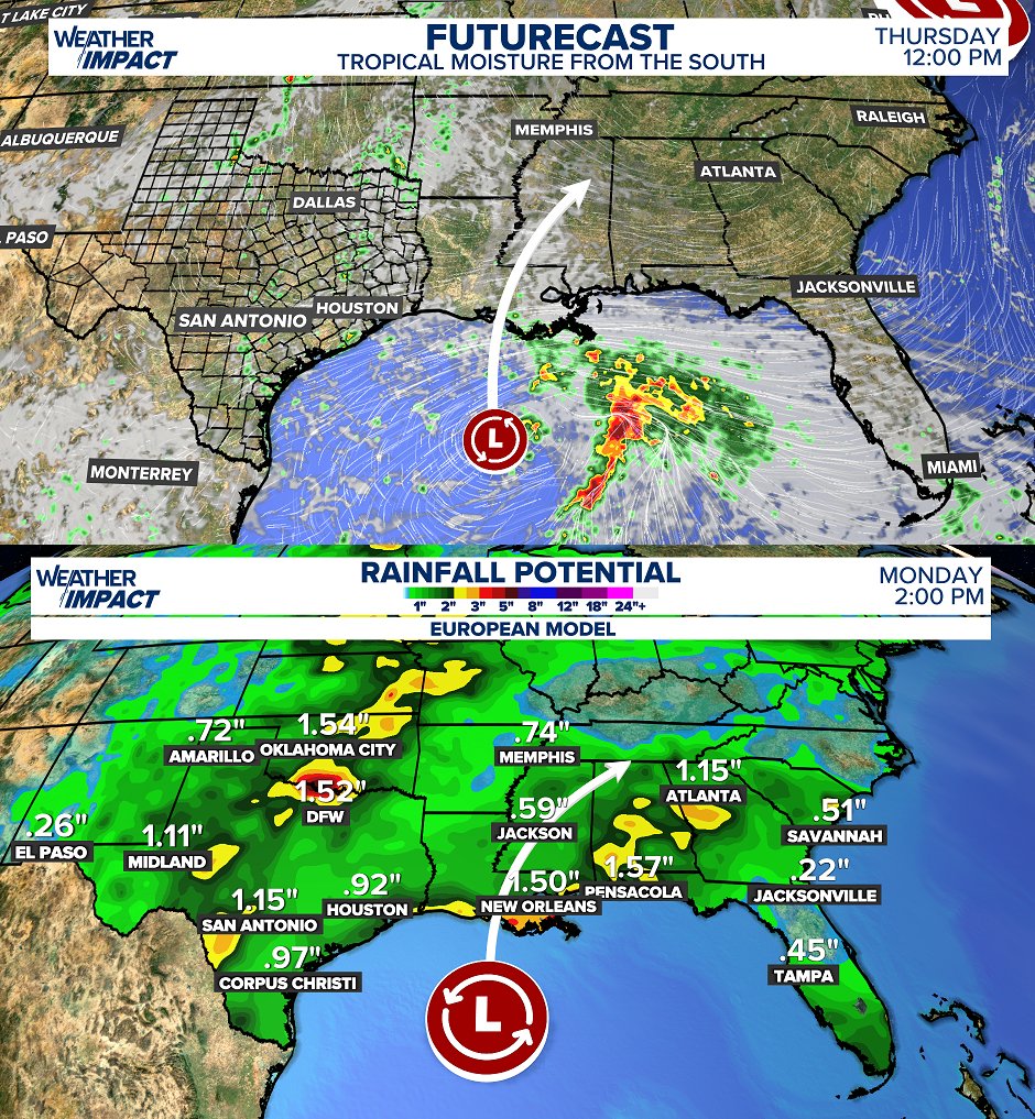
The combination of cooler drier air colliding with a tropical low off the Texas coast will create an unsettled pattern Monday - Thursday this week. Mostly for Central, South, and especially Southeast Texas. Don't drive through flooded roadways! #txwx
2
10
764
FLOOD RISK THIS WEEK 🌧️ While only a 'slight' risk for localized flooding the next few days, please be careful traveling! Roads can flood quickly and rain can lower visibility making it difficult to drive. Expect on and off rounds of rain through Wednesday. #txwx
1
2
5
614
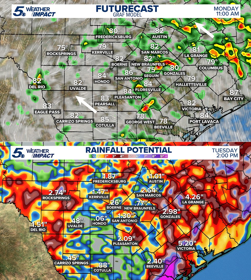
MORE RAIN ☔ As deep tropical moisture and cooler air from the north collide the next couple of days, this will create numerous showers and heavy downpours moving through South and Southeast Texas. Minor to moderate flooding will be a concern Monday and Tuesday. #txwx
1
5
618
Jun 12
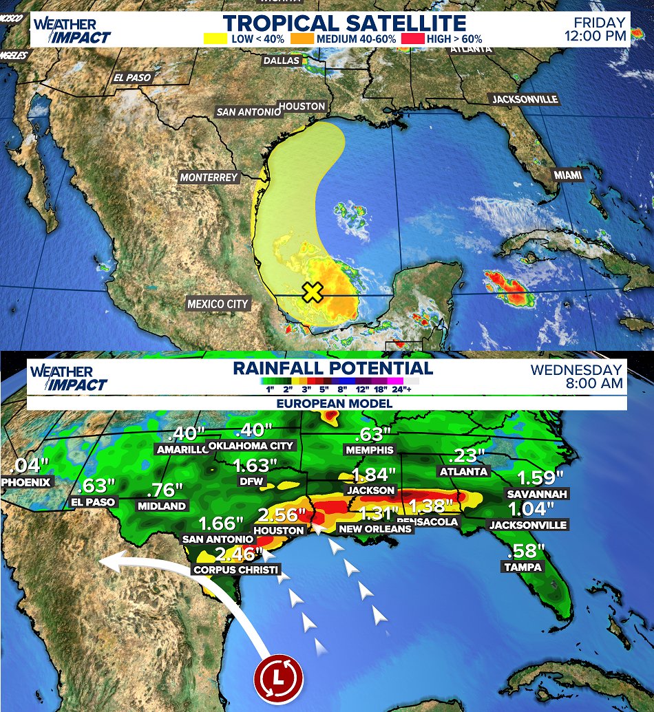
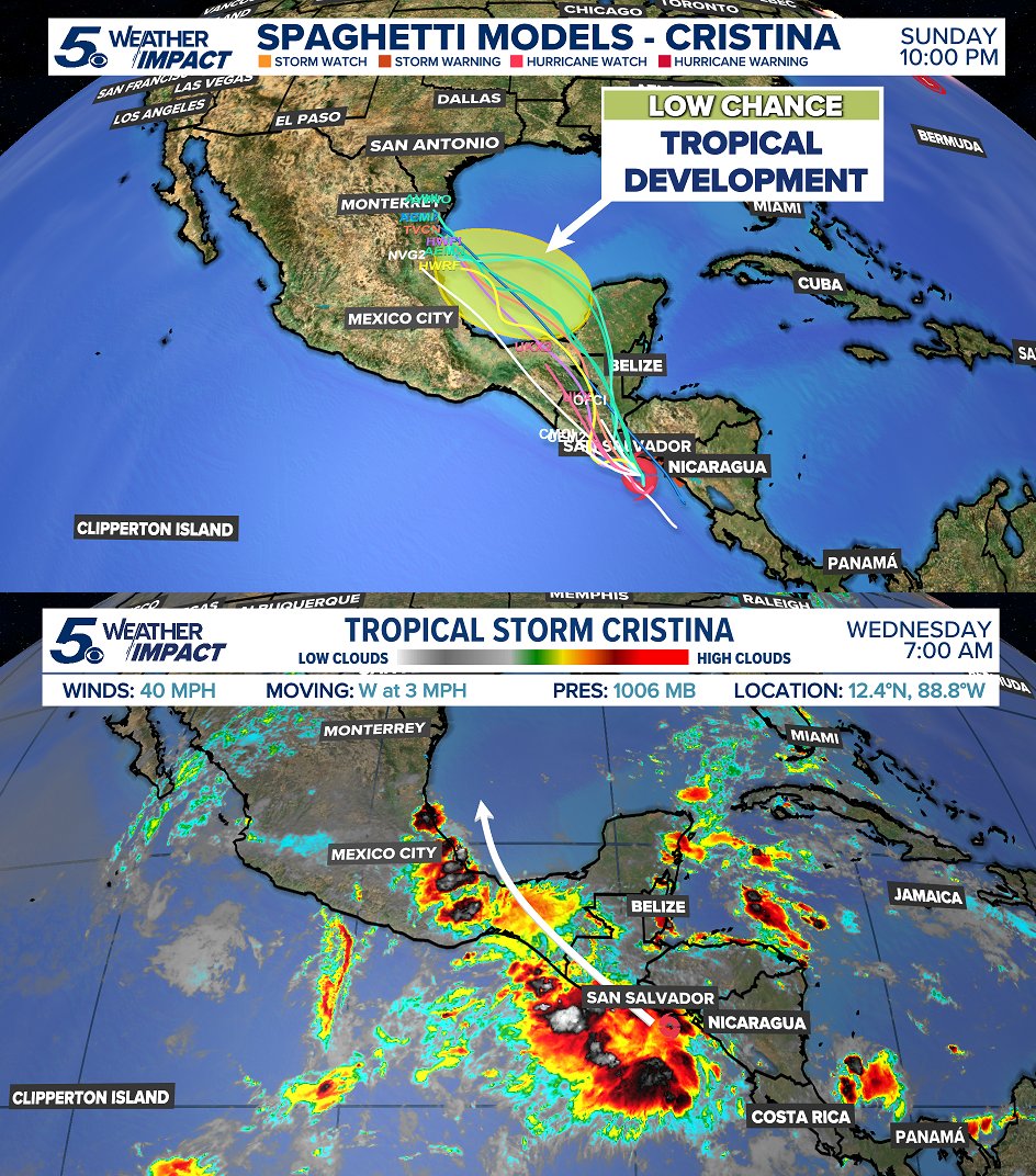
LOW chance for tropical storm development this weekend! However, the moisture will move northward starting on Sunday. This will create scattered rain and tropical downpours around Monday and early Tuesday. Some flooding possible! #txwx
116
Ryan Shoptaugh retweeted

Jun 10
Retweet if you’re a Spurs fan!
I wanna see something.
GO SPURS GO!!!
68
1,915
3,126
61,372
Jun 10
COOLER WITH MORE RAIN? ⛈️👀Next week, the pattern changes and "cooler" air pushes through Texas. Only a few degrees cooler. 80s instead of 90s. However, a front dropping in colliding with tropical humidity will spark some good rain coverage next week. #txwx
2
10
695
Jun 10
GULF TROPICAL LOW? ⛈️ Good news, this will stay weak and has a LOW chance for any tropical development into the weekend. This will be due to the remnants of Tropical Storm Cristina in the Pacific as it enters the Gulf. #txwx
1
4
601
GO SPURS GO 🎉Some spotty showers and isolated downpours will be likely as we move into the evening hours! Coverage will be mostly scattered. Keep in mind for any watch parties tonight! #txwx
1
3
580
MORE SCATTERED RAIN 🌧️While nothing severe expected, each afternoon and evening may feature a passing downpour with some thunder and lightning. Mostly into Friday and Saturday. Rain chances dropping into next week. #txwx
1
77
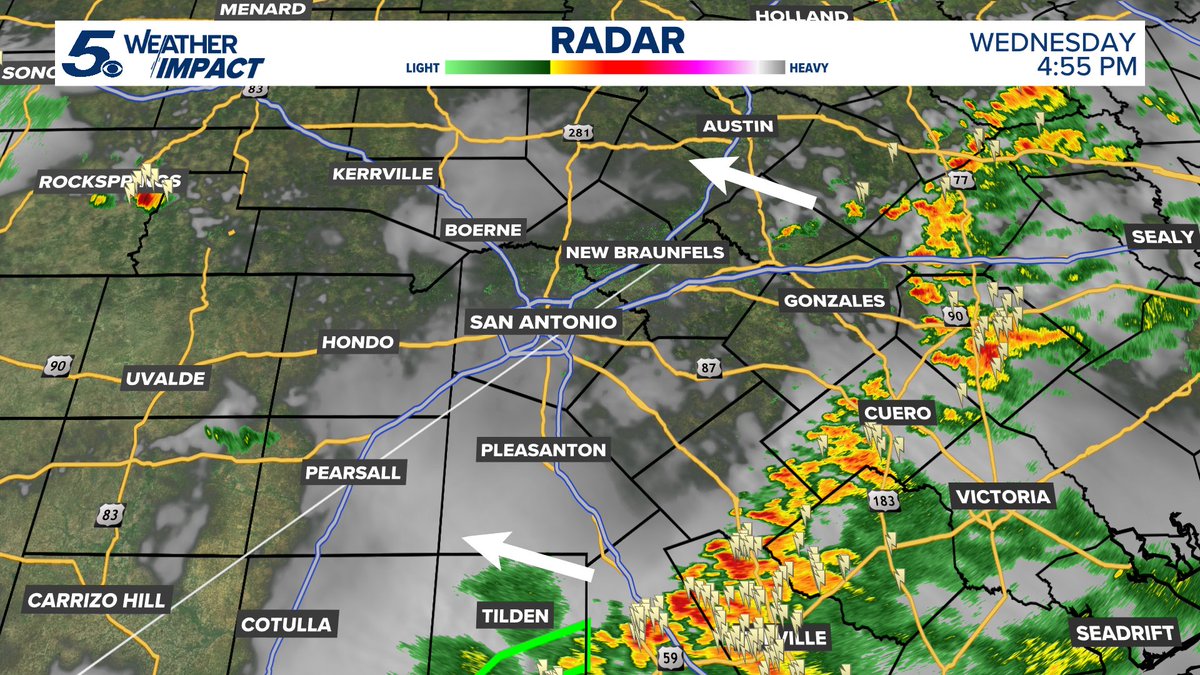
4:55 PM - Showers and scattered thunderstorms are gradually pushing northward today. Some will fall apart. Some will survive a trip to the San Antonio area through 8 PM tonight. #txwx
1
68
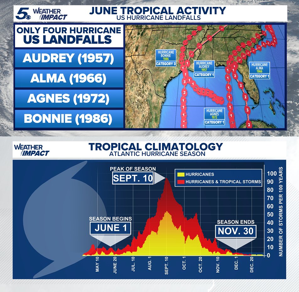
JUNE HURRICANES? 🌀 Has a hurricane ever hit the US in June? Yes, but it's RARE. Only four US hurricane landfalls have been observed in June. We have had landfalling tropical storms in recent years like Tropical Storm Claudette in June 2021. #txwx
2
2
593
Heaviest rain into the weekend will be 'mostly' east closer to the Houston area! Expect scattered pockets of rain and storms each afternoon and evening. Highest rain either east of west of the I-35 corridor. #txwx
1
7
635
TROPICAL LOW IN THE GULF ⛈️ Good news, this stays disorganized. Wind shear will keep it weak. However, disorganized tropical lows can spread out rain everywhere! Expect clouds and scattered rain with some storms into the weekend. #txwx
1
3
917
HURRICANE SEASON BEGINS ⛈️ Stronger wind shear is forecast to be present across the Atlantic Basin creating a more hostile environment to tropical systems. This is the reason why the forecast is 'below-normal" with 13 named storms expected. #txwx
1
1
5
321
SCATTERED STORMS THIS WEEK ⛈️ After Wednesday, tropical amounts of moisture will be driving in from the South into the weekend. Add in daytime heat and some lift, this will touch off scattered rain and storms in the area. Not a wash out every day. #txwx
1
10
621
May 31
GAME 1 NBA FINALS 🎉Temperatures will be warm and HUMID! A slight chance at afternoon and evening coastal showers and thunderstorms that may get close to San Antonio. GO SPURS GO! #txwx

1
102
May 29
Regardless of the track or tropical development into the first week of June, coastal scattered downpours look likely into the end of next week. A combination of sunshine, clouds and widely scattered tropical showers across South Texas. #txwx
1
12
927
May 29
TROPICAL RAINS INTO JUNE? ☔A couple of long-range models keep signaling at something tropical pushing in from the Gulf late next week. HOWEVER, each model takes it somewhere different. One towards Florida. One closer to Louisiana and Texas. Something to watch! #txwx

1
3
10
1,437