
- Tweets 36,934
- Following 368
- Followers 70,231
- Likes 2,411


ALT Beat the Heat during outdoor events: Drink plenty of water and encourage those with you to do the same. Wear a hat and lightweight, loose-fitting, and light-colored clothing. Apply sunscreen. Use an electric or handheld fan, cooling towels, or other cooling technology. Take breaks under shade, in cooling tents, or misting stations. At the first signs of dizziness or weakness, look for medical assistance.
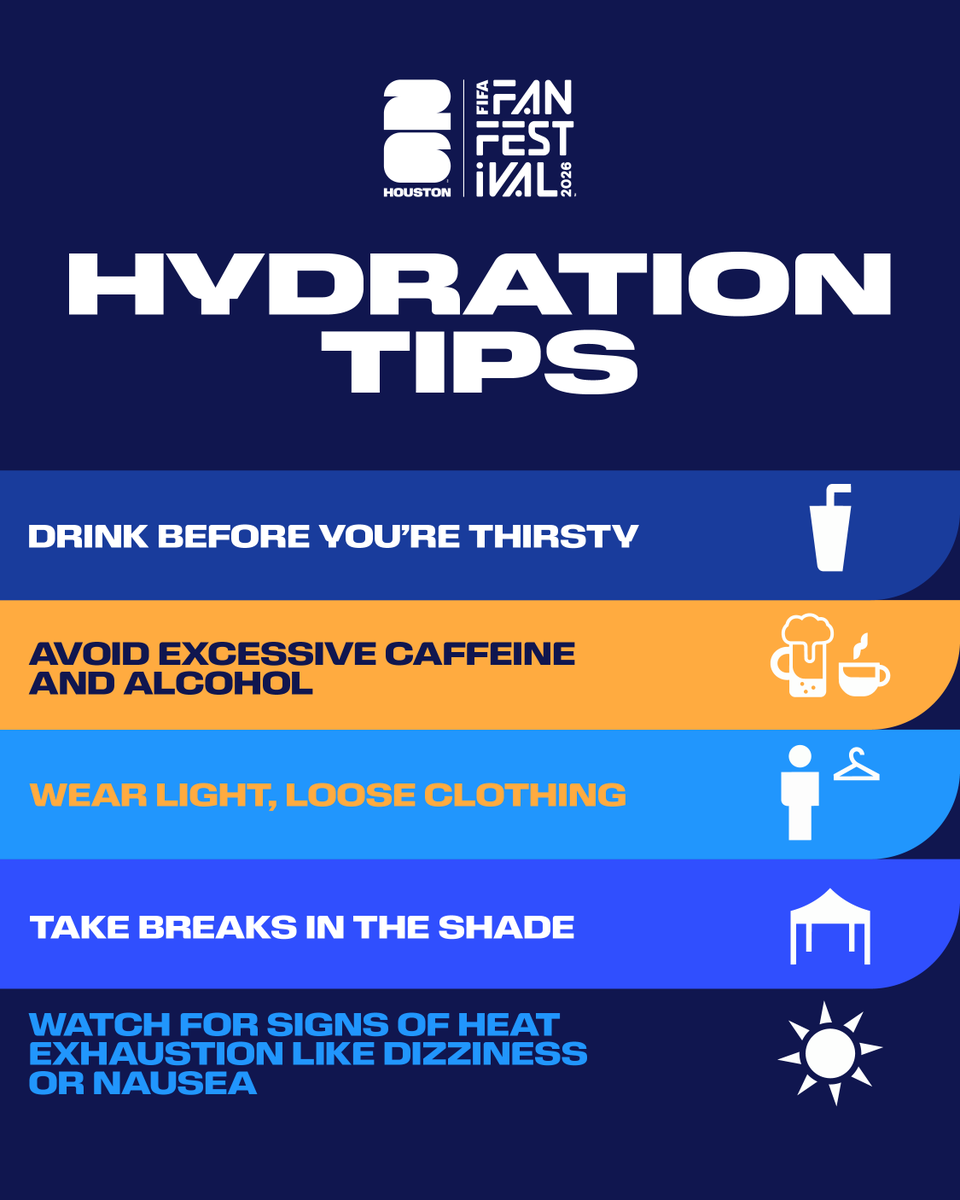

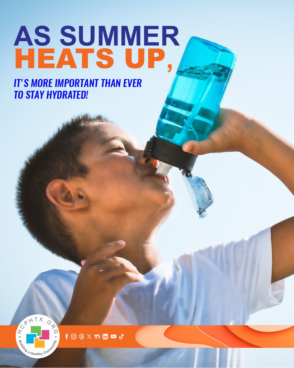
ALT A person drinks from a blue water bottle against a clear sky. The text reads, "As summer heats up, it’s more important than ever to stay hydrated!" The Harris County Public Health logo and various social media icons are at the bottom.
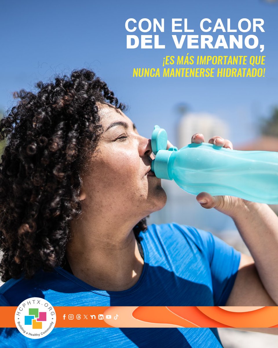
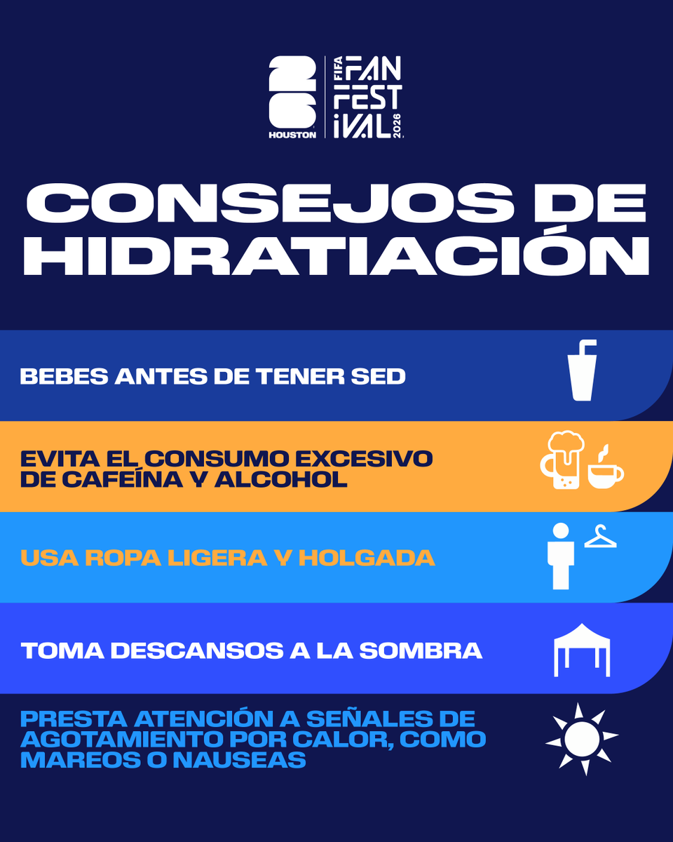
ALT A person drinks water from a reusable bottle on a sunny day. The text says in Spanish, “With the heat of summer, it’s more important than ever to stay hydrated!” A logo for Harris County Public Health is visible in the bottom left corner.

ALT Beat the Heat by staying hydrated, wearing loose, lightweight, light-colored clothing, and taking cold showers or baths when needed. Avoid strenuous outdoor activities or work during the hottest part of the day, and never leave people or pets inside a closed vehicle. Check on family members, seniors, and neighbors, and be aware of the signs of heat-related illnesses such as heat cramps, heat exhaustion, and heat stroke.
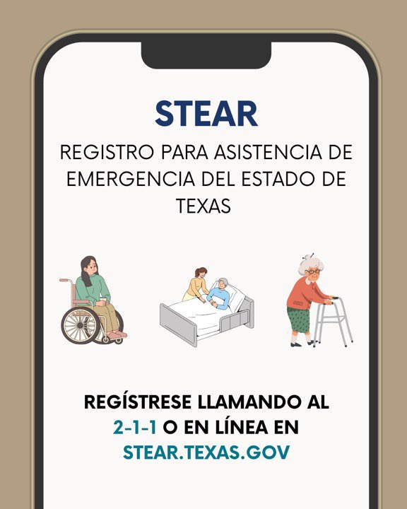
ALT State of Texas Emergency Assistance Registry, register by calling 2-1-1 or online at STEAR.TEXAS.GOV

ALT An infographic from the National Weather Service Houston/Galveston titled "Heat Continues Today" forecasting triple-digit heat index values for the week of June 13–19, 2026. Key bullet points state: Hot conditions continue through Sunday with heat indices reaching 100 to 105°F (37 to 41°C). A break in the heat is expected Monday and Tuesday due to cloud cover and rain. Hot conditions return mid to late next week. Safety icons advise staying hydrated, reducing outdoor time between 10 AM – 6 PM, wearing lightweight clothing, and checking on vulnerable groups. A "Maximum Heat Index (°F) Forecast" table lists daily peaks and weekly maximums for 10 Texas locations. The highest forecasted heat indices reach up to 109°F (in College Station, Conroe, and Livingston) later in the week (Thursday/Friday), while Monday and Tuesday show a noticeable dip into the 80s and 90s.


ALT An infographic from the National Weather Service Houston/Galveston titled "Tropical Weather Outlook: Monitoring A Disturbance," updated at 1 PM on June 12, 2026. A "Formation Chance: 20%" badge is highlighted in the top right. Key Messages: A tropical disturbance has a low (20%) chance of development over the Bay of Campeche/western Gulf this weekend. A broad area of low pressure is producing disorganized showers and storms over the Bay of Campeche. The system will move inland over Mexico this weekend but could re-emerge over the Gulf on Tuesday and Wednesday. Conditions are only marginally conducive for development. Residents and visitors are advised to monitor the forecast at weather.gov/houston. Map: A Seven-Day Graphical Tropical Weather Outlook from the National Hurricane Center shows a yellow shaded area with an "X" in the Bay of Campeche and western Gulf of Mexico, indicating a low (<40%) formation chance.

ALT An infographic from the National Weather Service Houston/Galveston titled "Increasing Rain Chances Sunday Afternoon/Evening: Locally Heavy Rainfall Possible," updated June 12, 2026. Key Messages: Scattered to widespread showers and storms are expected Sunday along a frontal boundary, with the best chances arriving in the early afternoon and continuing overnight. Potential Impacts & Actions: Locally heavy rain, gusty winds, and minor flooding in areas with repeated storms. The public is advised to remain weather-aware. Data Visualizations: Map: An "Excessive Rainfall" map for Sunday, June 14, shows a Flash Flood Risk level of 2 (out of 4) across most of Southeast Texas, including Houston, College Station, and Columbus. Table: A "Probability of Rain/Storms (%)" matrix lists over 20 cities. Rain chances spike drastically at 12 PM, 3 PM, and 6 PM, with many locations (like Bellville, Brenham, Katy, and The Woodlands) reaching an 80% peak probability.

ALT An infographic from the National Weather Service Houston/Galveston titled "Rain Continues, Chances Rise - Monday and Tuesday: Locally Heavy Rainfall Possible," updated June 12, 2026. Key Messages: Rain and storms increase by Monday as a frontal boundary moves through and tropical moisture filters in. Estimated rainfall totals are 1 to 3 inches across most locations through Tuesday, with isolated higher amounts of 4 to 5 inches possible. Potential Impacts & Actions: Locally heavy rain, gusty winds, frequent lightning, and minor flooding in areas with repeated storms. The public is advised to remain weather-aware. Excessive Rainfall Outlook Maps: Monday Map: Shows a yellow Flash Flood Risk level 2 (out of 4) covering central and coastal Southeast Texas (including Houston, Columbus, and Galveston), surrounded by a green level 1 risk. Tuesday Map: The risk decreases, showing a green Flash Flood Risk level 1 confined to the southern and coastal half of the region.
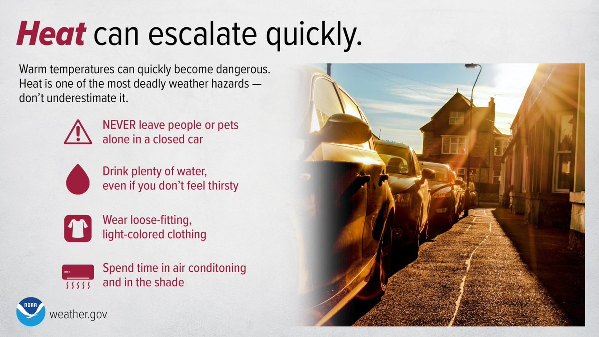
ALT An infographic from NOAA and weather.gov titled "Heat can escalate quickly." It features a photo of cars parked along a residential street under intense, bright sunlight. The text warns that warm temperatures can quickly become dangerous and that heat is a deadly weather hazard. It provides four safety tips paired with icons: Warning triangle: NEVER leave people or pets alone in a closed car. Water droplet: Drink plenty of water, even if you don't feel thirsty. T-shirt: Wear loose-fitting, light-colored clothing. Air conditioner: Spend time in air conditioning and in the shade.
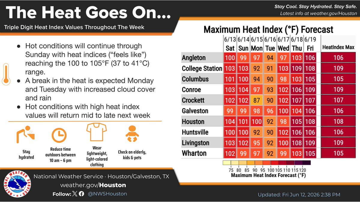
ALT An infographic from the National Weather Service Houston/Galveston titled "The Heat Goes On..." forecasting triple-digit heat index values for the week of June 13–19, 2026. Key bullet points state: Hot conditions continue through Sunday with heat indices reaching 100 to 105°F (37 to 41°C). A break in the heat is expected Monday and Tuesday due to cloud cover and rain. Hot conditions return mid to late next week. Safety icons advise staying hydrated, reducing outdoor time between 10 AM – 6 PM, wearing lightweight clothing, and checking on vulnerable groups. A "Maximum Heat Index (°F) Forecast" table lists daily peaks and weekly maximums for 10 Texas locations. The highest forecasted heat indices reach up to 109°F (in College Station, Conroe, and Livingston) later in the week (Thursday/Friday), while Monday and Tuesday show a noticeable dip into the 80s and 90s.

ALT An infographic from the National Weather Service Houston/Galveston titled "Tonight’s Outlook: Forecast Low Temperatures," updated on Friday, June 12, 2026. The left side displays key forecast details: Lows: 74–82°F (23–28°C), paired with a blue thermometer icon. Conditions: Warm and muggy overnight with light winds, paired with a night cloud icon. The right side features a regional map of Southeast Texas showing individual city low temperature forecasts, including 74°F in Crockett, 76°F in College Station and Conroe, 77°F in Houston, and the highest low of 82°F in Galveston. Cloud and moon icons are scattered on the map, along with a color-coded temperature scale on the right edge. NWS social media handles and weather.gov/Houston are listed at the bottom.

ALT An infographic from the National Weather Service Houston/Galveston titled "Saturday’s Outlook: Forecast High Temperatures," updated on Friday, June 12, 2026. The left side displays key forecast details: Highs: 88–93°F (31–34°C). Heat Indices "Feels Like": 100–107°F (37–42°C), paired with a red thermometer icon. Conditions: Isolated showers and storms in the late morning/afternoon. Hot and humid with a southeasterly breeze around 10–15 mph and gusts near 20 mph, paired with a sun, cloud, and wind icon. The right side features an orange and yellow color-coded regional map of Southeast Texas showing individual city highs, including 91°F in Houston and Brenham, 93°F in College Station and Conroe, and 94°F in Livingston. Several "ISOLATED" thunderstorm icons are overlaid across the region. NWS social media handles and weather.gov/Houston are listed at the bottom.

ALT Poster titled 'Beat the Heat Checklist' featuring two young soccer players in action on a field. The checklist advises to drink water, spend time in air‑conditioned spaces, limit outdoor activities, wear a hat and sunscreen, wear lightweight clothing, and have a fan on hand. The poster includes logos for Harris County Public Health and social media handles.

ALT Poster titled 'Beat the Heat Checklist' featuring two young soccer players in action on a field. The checklist advises to drink water, spend time in air‑conditioned spaces, limit outdoor activities, wear a hat and sunscreen, wear lightweight clothing, and have a fan on hand. The poster includes logos for Harris County Public Health and social media handles.