A severe thunderstorm watch has been issued for parts of Delaware, Maryland, New Jersey, New York and Pennsylvania until 1 AM EDT
ALT This graphic displays Severe Thunderstorm watch number 337 plotted on a map. The watch is in effect until 1:00 AM EDT. The watch includes parts of Delaware, Maryland, New Jersey, New York and Pennsylvania. The threats associated with this watch are a couple tornadoes possible, isolated hail up to quarter size possible and scattered gusts up to 70 mph likely. There are 13,435,951 people in the watch along with 3442 schools and 255 hospitals.
Severe thunderstorms can develop quickly and bring dangerous lightning, heavy rain, and strong winds. When thunder roars, go indoors. Stay informed, avoid open areas and tall trees, and monitor local weather conditions. Get preparedness tips at ready.nj.gov. #ReadyNJ
We're still looking at a threat for severe weather later today though the timing looks to be slightly later than previous thinking as the best chance for severe storms will be during the evening period. #PAWX#NJWX#MDWX#DEWX
⚽ Heading to NJNY Stadium with NJ TRANSIT?🚆 Here's everything you need to know for match day!
Plan ahead, arrive on time, and let NJ TRANSIT get you to kickoff! ⚽
For more information visit njtworldcup.com
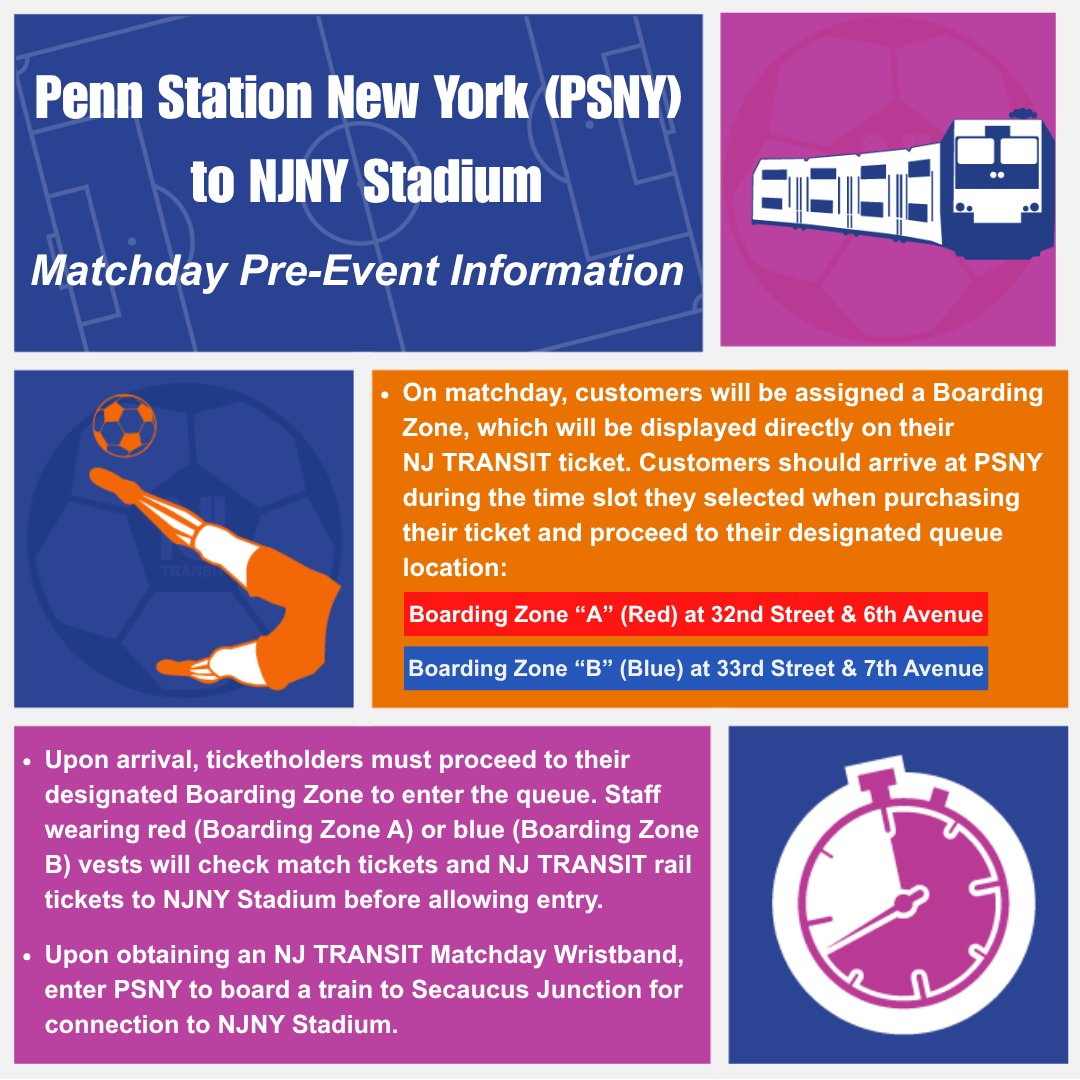
ALT This image provides information about traveling from Penn Station New York (PSNY) to NJNY Stadium. It explains that customers will be assigned a Boarding Zone (Red or Blue) on their NJ TRANSIT tickets, viewable during purchase. Red is at 32nd Street & 7th Avenue, and Blue is at 33rd Street & 7th Avenue. The image also mentions the requirement of an NJ TRANSIT Matchday Wristband for boarding either zone or traveling to Secaucus Junction for connection to NJNY Stadium. Various icons depict a train, map location, and ticket information.
ALT A promotional graphic for "Hoboken Terminal to NJNY Stadium" with matchday pre-event information. It includes a soccer ball icon and NJ TRANSIT train illustration. Instructions are provided for ticket holders, emphasizing the need to go to Boarding Zone HOB (Purple) near Track 18 for ticket checks and NJ TRANSIT train access. Staff will be in soccer-themed attire to assist. The graphic also highlights that an NJ TRANSIT Matchday Wristband is required for travel, with a "No Wristband, No Ride" reminder.
ALT NJ TRANSIT matchday information graphic. Includes a train, soccer ball, and a hand with a wristband. It states that customers traveling from NJ TRANSIT stations must transfer at Secaucus Junction or Hoboken Terminal to reach NJNY Stadium. Return trips to Hoboken also require transfer at Secaucus Junction. A wristband is required for boarding, provided after ticket inspection. "No Wristband, No Ride.
The world's game comes to New Jersey TOMORROW! Secure your ride with NJ TRANSIT now!
Use your ticket for unlimited travel on NJT on matchday and arrive steps from the action!
🌎 Buy your travel tickets now through the NJ TRANSIT Mobile App. Details at njtworldcup.com
Beat the heat by visiting a Cooling Center. Cooling Centers provide a safe, air-conditioned place to stay cool during periods of extreme heat. To find a Cooling Center near you, contact NJ 2-1-1 or visit nj211.org. Stay cool, stay hydrated, and stay safe. #ReadyNJ
A severe thunderstorm watch has been issued for parts of Connecticut, Massachusetts, New Jersey, New York and Pennsylvania until 9 PM EDT
ALT This graphic displays Severe Thunderstorm watch number 322 plotted on a map. The watch is in effect until 9:00 PM EDT. The watch includes parts of Connecticut, Massachusetts, New Jersey, New York and Pennsylvania. The threats associated with this watch are no tornadoes expected, isolated hail up to quarter size possible and scattered gusts up to 70 mph possible. There are 25,176,893 people in the watch along with 5983 schools and 294 hospitals.
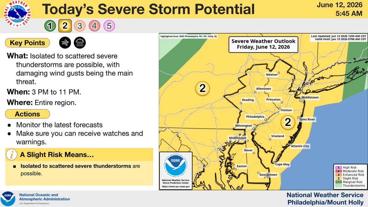
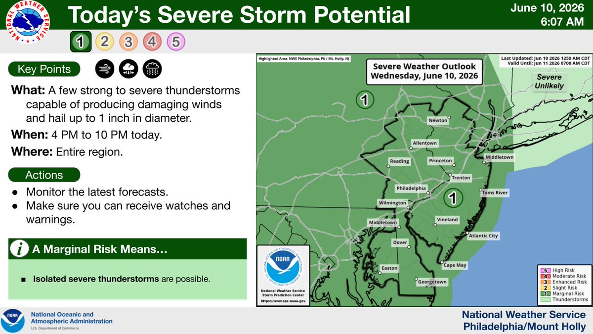
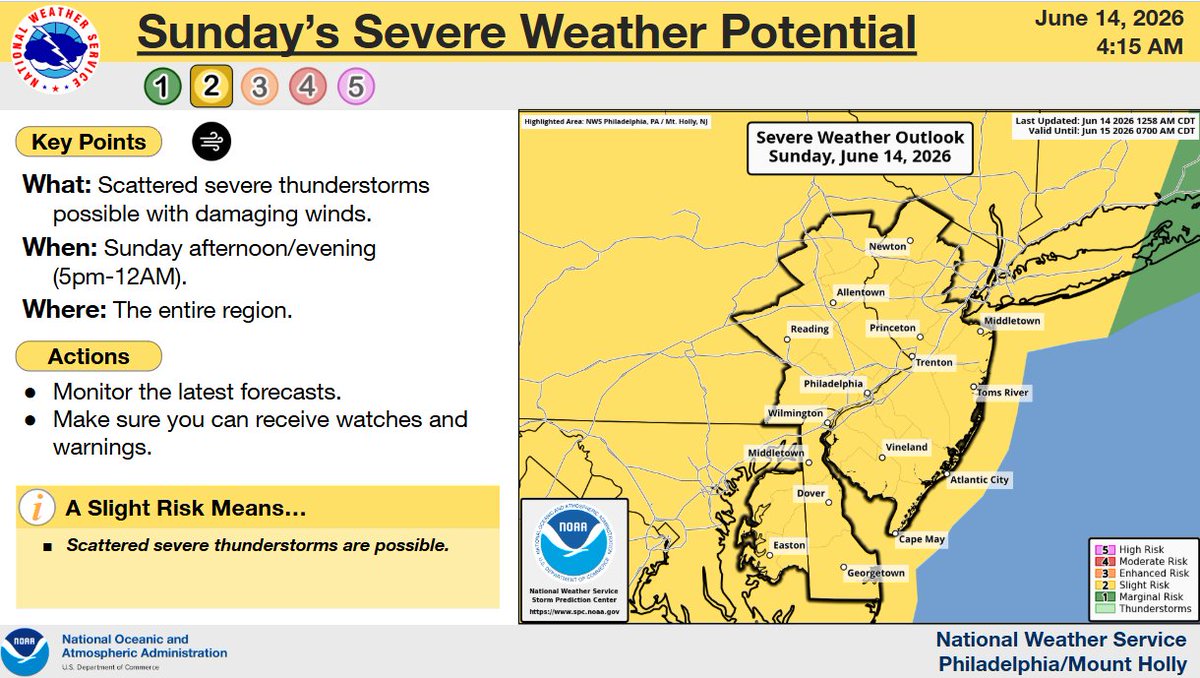
⛈️ A few severe storms are possible again later this afternoon and evening. Coverage of storms is anticipated to be lower than Thursday, and not everyone will see storms. Damaging wind gusts are the main threat today. Remain alert for changing conditions! #PAwx#NJwx#DEwx#MDwx
⚠️🔥 One day left of the oppressively hot and humid conditions. A few severe storms will be possible again this afternoon and evening, but not everyone will get a storm. It will turn much less humid for Saturday, but high temperatures will remain in the upper 80s to near 90°.
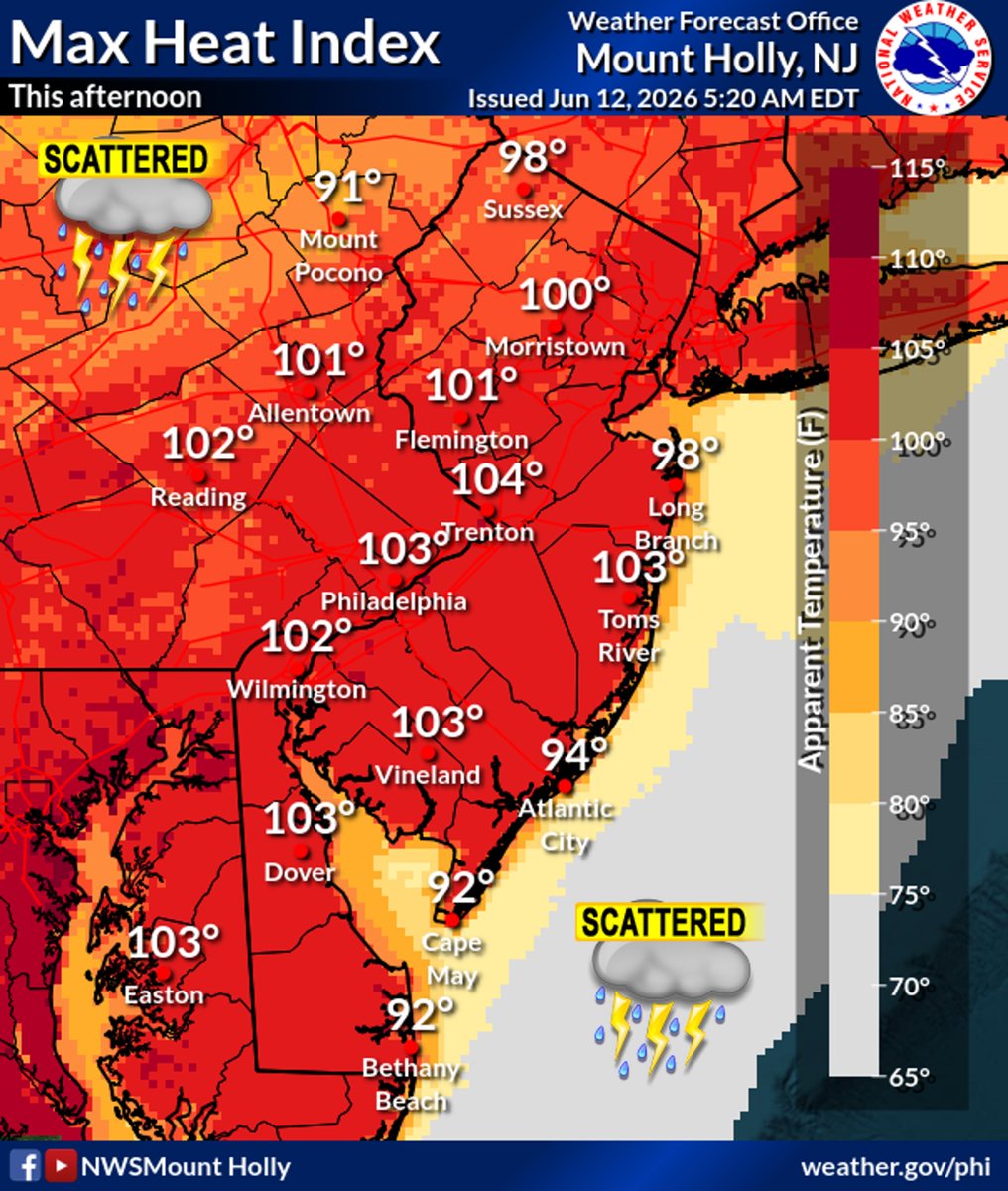
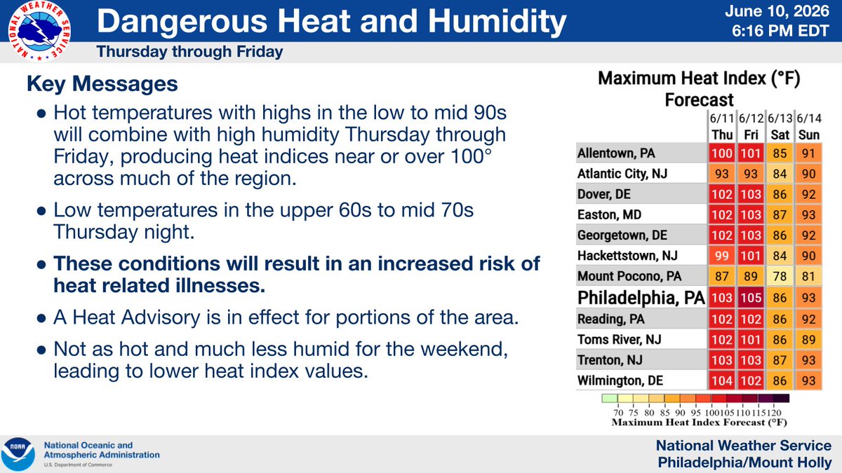
ALT The forecast of maximum heat index for this afternoon.
A severe thunderstorm watch has been issued for parts of Delaware, Maryland, New Jersey, New York, Pennsylvania and Virginia until 12 AM EDT
ALT This graphic displays Severe Thunderstorm watch number 317 plotted on a map. The watch is in effect until 12:00 AM EDT. The watch includes parts of Delaware, Maryland, New Jersey, New York, Pennsylvania and Virginia. The threats associated with this watch are no tornadoes expected, isolated hail up to quarter size possible and scattered gusts up to 65 mph possible. There are 27,572,039 people in the watch along with 6473 schools and 372 hospitals.
Extreme heat can be dangerous. Stay hydrated, limit outdoor activities during the hottest part of the day, and check on family, friends, and neighbors. If you need a place to cool off, contact NJ 2-1-1 or visit nj211.org to find a Cooling Center near you. #ReadyNJ
⚠️🥵⛈️ The hottest heat indices so far this year are expected today, topping out near 100° this afternoon in most areas. Near record breaking highs in the low to mid 90s. A Heat Advisory remains in effect through Friday for portions of the area. #PAwx#NJwx#DEwx#MDwx
ALT Forecast maximum heat indices for this afternoon.
⚠️Dangerous heat and humidity expected Thursday and Friday🌡️ Hot temperatures combined with high humidity will result in heat index values around or over 100° Thursday and Friday. These conditions will cause an increased risk for heat related illnesses for much of the population.
If using the official rideshare service, please note that the designated drop-off location is approximately 1.3 miles from the stadium.
Arrive early and allow extra travel time to ensure a smooth experience.
nynjfwc26.com/getting-to-nyn…
⛈️ Scattered showers and storms are forecast to develop this afternoon and evening. A few storms could be strong to severe, with locally damaging winds and brief heavy downpours possible. #PAwx#NJwx#DEwx#MDwx
For critical FIFA-related updates, transportation information, and real-time public safety alerts in the NY/NJ region, download the New Jersey State Police Public Safety App. Staying informed is an important part of ensuring a safe and enjoyable event experience.