
Joined May 2013
- Tweets 29,022
- Following 4,016
- Followers 23,832
- Likes 19,889
14,971 Photos and videos


Pinned Tweet

Feb 20
My derelictsites.com/ website has just gone live.🏚️⚡️🎉
I've created a data-led project focused on vacancy and dereliction in Ireland as part of the wider housing and town-centre crisis.
This regeneration project examines the scale and impact of derelict and long-term vacant properties. The public-facing landing page at derelictsites.com/ reviews derelict sites currently on the register across five local authorities—Cork County Council, Cork City Council, Dublin City Council, Limerick City & County Council, and Mayo County Council. I've built a digital database to increase transparency and visually identify dereliction hotspots across each county. This map-based public register tracks locations, enforcement steps, and estimated values. It includes photos of derelict sites and Google Street View links to make the records easier to understand. I've also included useful links and available grants explaining the Derelict Sites Process Workflow.
This is a public-facing landing page for draft demonstrations built by me. It provides an overview and links to each register and supporting information. This is a demonstration platform and portfolio project that shows how statutory register data can be structured for public transparency and internal decision support.
This website is a regeneration-focused initiative documenting and analysing derelict and long-term vacant property in Ireland. Built as a structured, evidence-led platform, it converts fragmented statutory registers into a clear, map-based resource revealing the scale, geography, and real-world impacts of vacancy, underuse, and town centre decline.
The project does more than highlight dereliction as a problem. By combining clean, structured data, mapping, and accessible communication, it helps local authorities, practitioners, and the public understand where dereliction is concentrated, what stage cases are at, and what opportunities exist for regeneration.
Through developing this platform, I am building practical expertise in vacancy classification, data cleaning and standardisation (including address and Eircode quality), mapping and visualisation, and stakeholder-focused reporting. My goal is to contribute to a local authority or housing regeneration teams working on Town Centre First delivery, vacant homes activation, and sustainable reuse strategies—bringing a strong digital and data-led approach to real-world implementation.
🔮 Future plans:
Expand coverage: Add more local authority registers while maintaining a consistent structure and terminology. Include vacant sites in the register database.
Improve data quality: Standardise addresses, add Eircodes where missing, and document a repeatable QA workflow.
Richer enforcement timelines: Track key statutory stages and dates more consistently, so progress and delays are visible.
Better analytics: Add district and town breakdowns, CPO numbers, trend views such as dereliction clusters, and "time on register" metrics to highlight long-standing cases.
Case studies: Include short, evidence-based examples of successful reuse (before/after, costs, barriers, outcomes).
Decision-support outputs: Create exportable reports and summaries that support internal briefings and member queries.
For collaboration, feedback, or demonstration requests, please get in touch.
Regards
Rob Cross
15
57
166
13,979
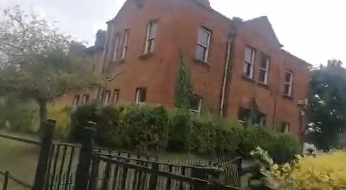
In the midst of a housing crisis, a record 17,548 people are accessing state-funded emergency accommodation across Ireland, including 11,944 adults and 5,604 children. It is shameful to see Garda Terrace: a two-storey, red-brick terrace inside the Phoenix Park, on North Road beside the An Garda Síochána headquarters. Built in the 1880s as married quarters for the Royal Irish Constabulary, and later used by An Garda Síochána, it is divided into 12 flats. Although a protected structure, it has steadily fallen into disuse: as of mid-2025, only two of the 12 flats were occupied, with the remainder boarded up. Owned by the Office of Public Works, it is a prominent example of long-term, State-owned residential vacancy amid a housing crisis.
Below is a website I built to highlight dereliction in Ireland, propose solutions, and showcase heritage buildings and structures at risk.
📍 Survey Research Details:
derelictsites.com/6746-Garda…
#HousingCrisis #DerelictIreland #VacantIreland #Dublin #Ireland #Heritage #HeritageAtRisk #BuiltHeritage
4
7
28
1,709
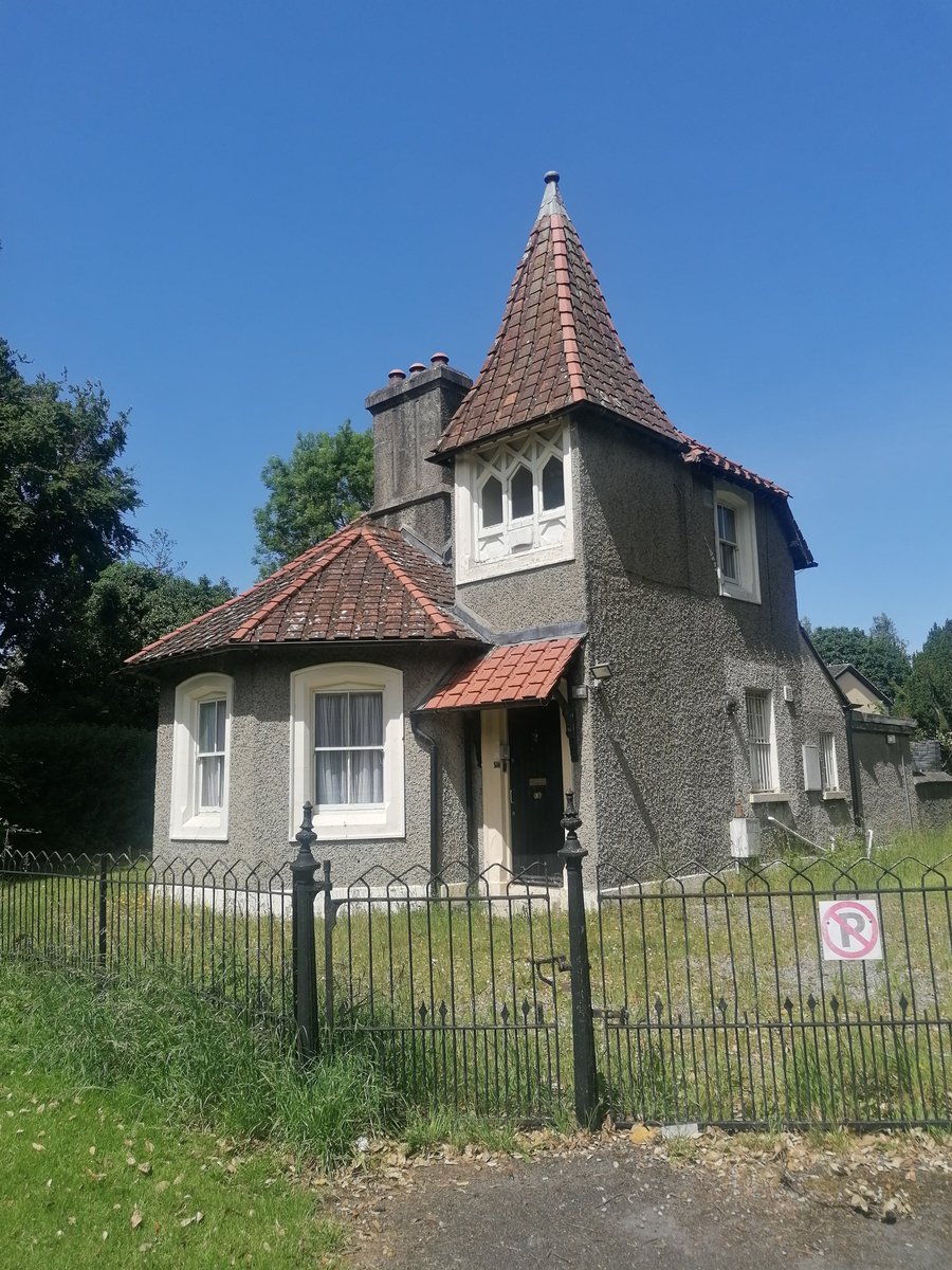
Amid a housing crisis, it is shameful to see the Constable’s Lodge, owned by the OPW, lying vacant. This protected, detached, two-storey former park constable’s lodge is located off the North Road, south-east of Phoenix Park School, Dublin 8. It was built in 1872–77 to designs by Enoch Trevor Owen.
Below is a website I built to highlight dereliction in Ireland, propose solutions, and showcase heritage buildings and structures at risk.
📍 Survey Research Details:
derelictsites.com/6780-Const…
#HousingCrisis #DerelictIreland #VacantIreland #Dublin #Ireland #Heritage #HeritageAtRisk #BuiltHeritage
1
7
40
2,172
Murray’s Bar on Sean McDermott Street, Dublin 1, was demolished in the 1980s as part of a £10 million inner-city urban renewal project, with Dublin Corporation demolition teams levelling the entire area.
@RTEArchives
rte.ie/archives/2021/0526/12…
#Dublin #IrishPubs #Lastorders
1
2
955
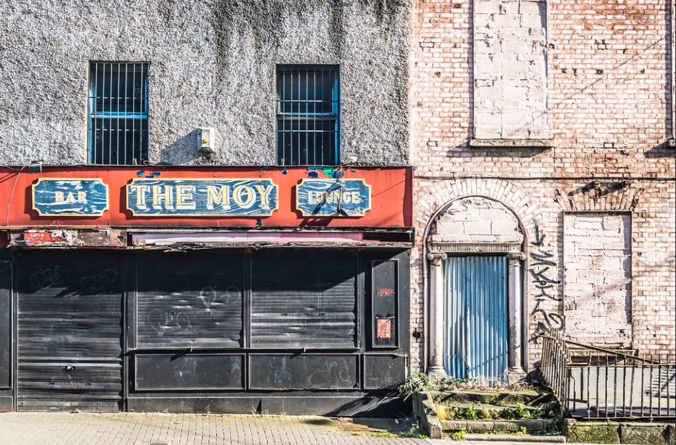
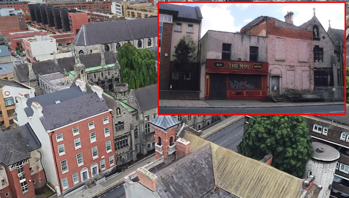
The Moy bar on 13 Dorset Street Upper, Dublin 01, was demolished around 2018–2019.
#Dublin #Lastorders
9
2,143
Jun 13
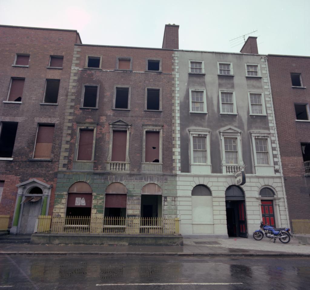
A roofless Georgian shell, slated for demolition in 2007 — refused. Now reinstated as homes. Proof that protected ≠ lost. 🏚️🏦
The Moy pub on Dorset Street was demolished around 2018–2019. Next door, No. 12 Dorset Street Upper is a protected structure traditionally linked with Richard Brinsley Sheridan’s birthplace. It stood roofless for decades after its top two floors were removed in the 1980s. A 2007 proposal to demolish Nos. 12–13 for apartments was refused on appeal. The site was later redeveloped (c. 2021) as “12–13 Dorset Street Upper”, reinstating No. 12 and building a matching No. 13 to provide 9 apartments, resolving the dereliction.
Below is a webpage I built to highlight dereliction in Ireland, propose solutions, and showcase heritage buildings and structures at risk.
📍 Survey Research Details:
derelictsites.com/2330-12-Do…
#Dublin #Ireland #Heritage #HeritageAtRisk #BuiltHeritage
2
5
37
2,583
Jun 12
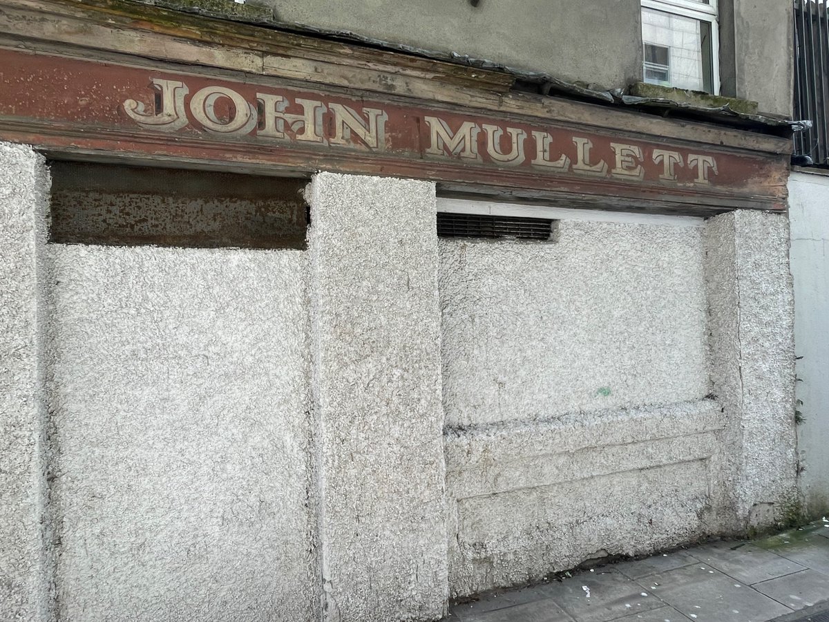
Would love to see the Mullett's Pub original facade restored to its former glory. 🙏
#dublin #HeritageAtRisk #Ulysses
Google Street View: maps.app.goo.gl/ksc8KC2CCFt8…
Jun 12

Historic signage for Mullett’s on the Foley Street side. Mentioned in Ulysses (Stephen and Bloom stumble past it and The Signal House) it is a rare surviving element of Nighttown as it appears in the book. Mullett’s is still trading. Thanks to Jimmy Murphy bringing me to see.
1
2
15
2,326
Rob Cross retweeted
Jun 12
1
10
986
Jun 12
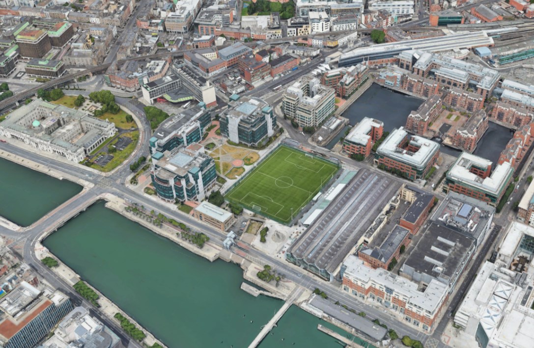
From drained dock to dream pitch. George’s Dock has sat empty for years in the heart of Dublin 1, beside the richest square mile in Ireland and one of its most deprived communities. Give kids a place to play.
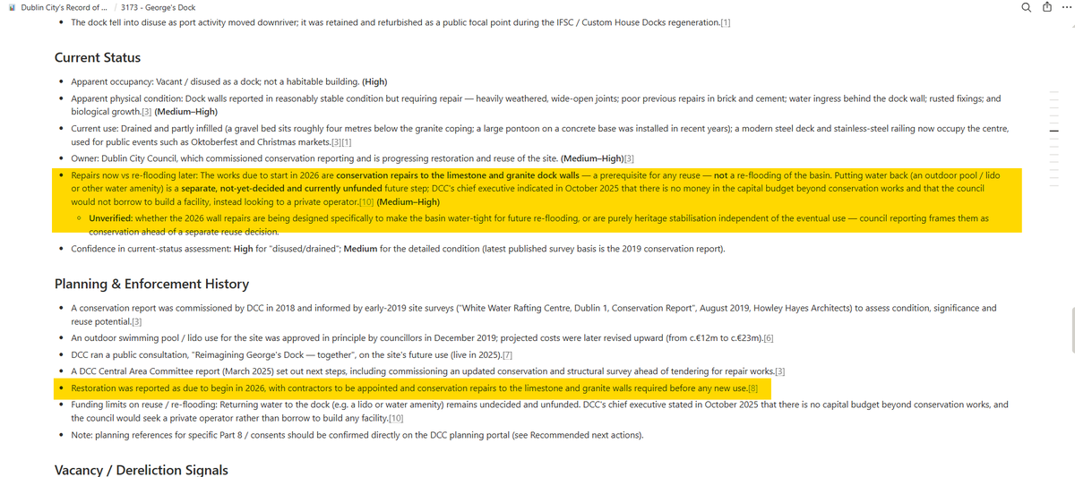
George’s Dock is an early-19th-century stone wet dock in Dublin’s Docklands, designed by engineer John Rennie and opened in 1821 as part of the Custom House Docks complex. It is a protected structure, valued for its Georgian maritime engineering and masonry. Today, the dock is drained, partly infilled, and largely disused, serving mainly as an occasional outdoor events space
Below is a webpage I built to highlight dereliction in Ireland, propose solutions, and showcase heritage buildings and structures at risk.
📍 Survey Research Details:
derelictsites.com/3173-Georg…
#Dublin #Ireland #Heritage #HeritageAtRisk
#BuiltHeritage
14
11
119
23,883
Jun 12
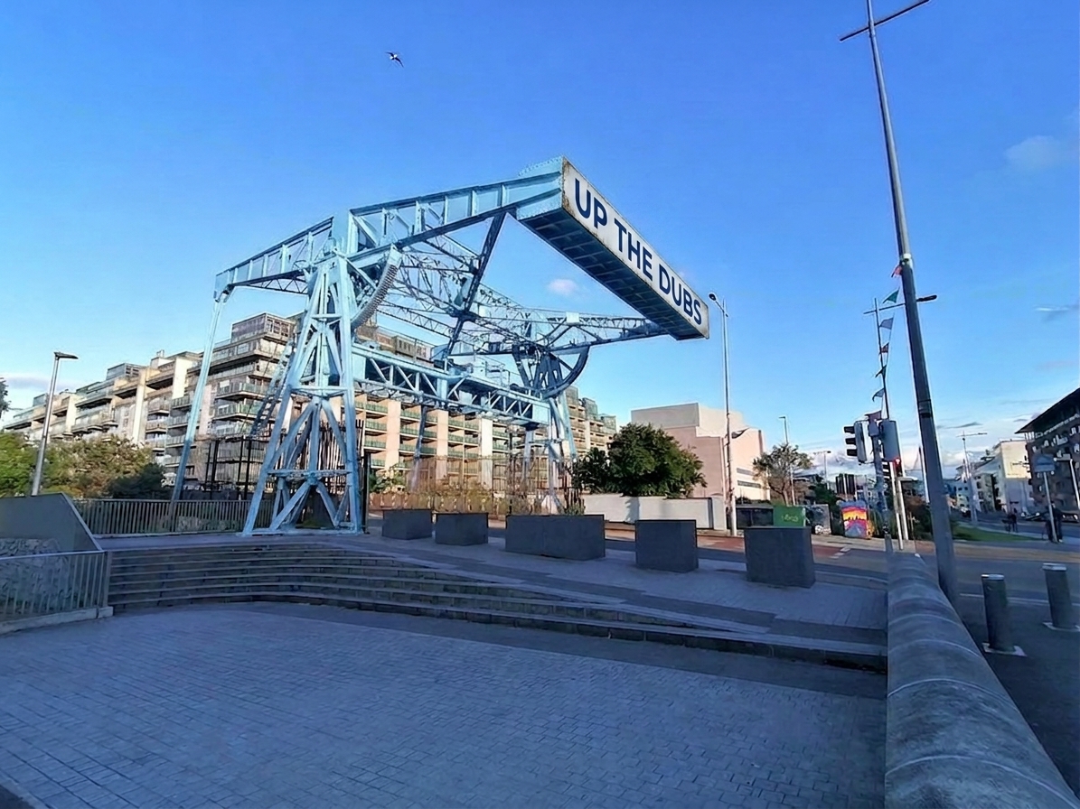
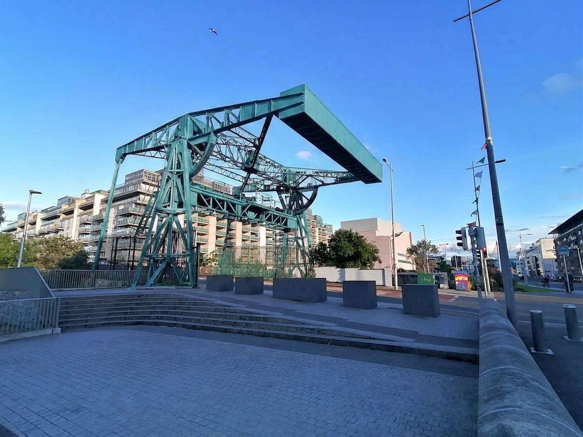
Dublin's 1941 Sheriff Street Lifting Bridge is rusting at Spencer Dock. Surely it's worth a lick of paint? 👨🎨🎨
#Dublin #Ireland #Heritage #HeritageAtRisk
Below is a webpage I built to highlight dereliction in Ireland, propose solutions, and showcase heritage buildings and structures at risk.
📍 Survey Research Details:
derelictsites.com/Not-on-RPS…

9
12
109
7,283
Jun 12
'Nowadays people know the price of everything and the value of nothing.' Oscar Wilde, The Picture of Dorian Gray
Stone Villa is an early-19th-century stone-faced villa, a protected structure (RPS 1727), standing at the front of a 0.27-hectare infill site off the North Circular Road in Phibsborough, Dublin 7. The house has been vacant for decades and is boarded up and dilapidated, with its windows blocked up with concrete blocks and the surrounding site extensively overgrown.
Below is a webpage I built to highlight dereliction in Ireland, propose solutions, and showcase heritage buildings and structures at risk.
📍 Survey Research Details:
derelictsites.com/1727-297-C…
👀Google Street View:
maps.app.goo.gl/UKpvopcriZPf…
#HousingCrisis #DerelictIreland #VacantIreland #Dublin #Ireland #Heritage #HeritageAtRisk
1
13
46
3,004
Jun 12
At its peak, nearly 30% of Irish households were in energy poverty. Just to let people know, SEAI offer a range of grants, but one to check out is their FULLY FUNDED Warmer Homes upgrades for eligible households.
Eligibility (all 3 must apply):
1. You own and live in the home as your primary residence.
2. The home was built and occupied before 2006.
3. You receive one of the qualifying welfare payments: Fuel Allowance, Working Family Payment (WFP), One-Parent Family Payment, Domiciliary Care Allowance, Carer's Allowance (living with the person you care for), Job Seeker's Allowance (6 months with a child under 7), or Disability Allowance (6 months with a child under 7).
Apply here: onlinewhs.powerappsportals.c…
ℹ️Useful Links and Grants Available:
derelictsites.com/c-Useful-L…
#Ireland #SEAI #FuelPoverty
1
1
2
451


Rob Cross retweeted
Jun 11
These six Georgian properties on Clare Street should be included in the Limerick Record of Protected Structures.
1
2
6
600
Rob Cross retweeted
Jun 11
ℹ️The footprint area of these data centre buildings alone is 83 hectares, which could accommodate 2,905–4,150 homes, based on a standard suburban/townhouse density of 35–50 homes per hectare.

1
4
9
2,180