
Senior Chief Meteorologist. I point at a big green wall early in the morning. Pet peeves: ATM fees and the phrase 'Is it gonna tornado?'
Joined August 2008
- Tweets 63,221
- Following 761
- Followers 30,990
- Likes 22,613
31,255 Photos and videos


Pinned Tweet
Heads up for all those using my feed during severe weather. My posts getting throttled here quite a bit when there are a lot of warnings. Please follow my FB feed for more info. Nothing I can do about it.
1
50
9,300
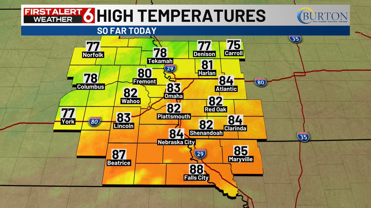
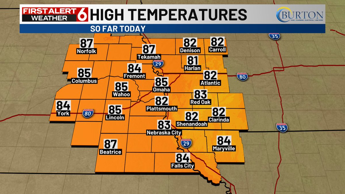
Here's a look at the high temperatures across our area from earlier today.
2
3
1,601
FIRST ALERT: A Flash Flood Warning is currently in effect for Nodaway, Holt, Atchison, Worth county until Jun 14 12:45AM. If you are in a flood prone area, seek higher ground immediately.
3
3
1,530
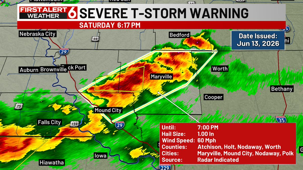
A Severe Thunderstorm Warning is in effect for Nodaway, Holt, Atchison, Worth until Jun 13 7:00PM. Large hail and/or damaging winds of at least 60mph are possible. If you are in the warning area, seek shelter immediately.
3
6
1,854
A Severe Thunderstorm Warning is in effect for Pawnee, Richardson until Jun 13 5:45PM. Large hail and/or damaging winds of at least 60mph are possible. If you are in the warning area, seek shelter immediately.
3
3
1,883
FIRST ALERT: A Severe Thunderstorm Watch is currently in effect for portions of our viewing area until Jun 13 11:00PM. A Severe Thunderstorm Watch means that conditions are favorable for the development of severe storms. Stay tuned for possible warnings.
1
6
13
3,127

Jun 13
A Severe Thunderstorm Warning is in effect for Montgomery until Jun 13 10:15AM. Large hail and/or damaging winds of at least 60mph are possible. If you are in the warning area, seek shelter immediately.
2
3
1,894
Jun 13
A Severe Thunderstorm Warning is in effect for Page, Fremont until Jun 13 10:15AM. Large hail and/or damaging winds of at least 60mph are possible. If you are in the warning area, seek shelter immediately.
3
4
2,048
Jun 13
A Severe Thunderstorm Warning is in effect for Cass, Adams until Jun 13 10:00AM. Large hail and/or damaging winds of at least 60mph are possible. If you are in the warning area, seek shelter immediately.
2
6
2,236
Jun 13
A Severe Thunderstorm Warning is in effect for Montgomery, Pottawattamie, Mills until Jun 13 9:45AM. Large hail and/or damaging winds of at least 60mph are possible. If you are in the warning area, seek shelter immediately.
2
6
1,916
Jun 13
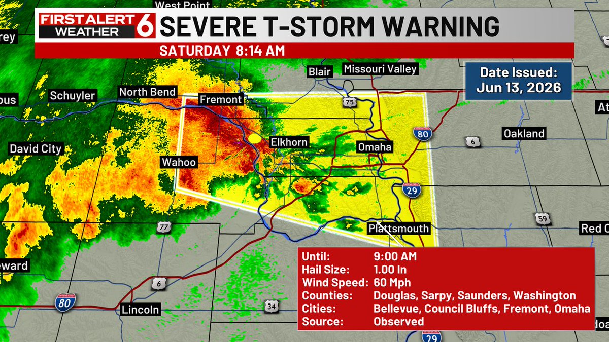
A Severe Thunderstorm Warning is in effect for Douglas, Sarpy, Pottawattamie, Mills, Washington, Cass until Jun 13 9:30AM. Large hail and/or damaging winds of at least 60mph are possible. If you are in the warning area, seek shelter immediately.
3
11
2,352
Jun 13
A Severe Thunderstorm Warning is in effect for Douglas, Sarpy, Pottawattamie, Dodge, Saunders, Cass, Washington, Mills until Jun 13 9:00AM. Large hail and/or damaging winds of at least 60mph are possible. If you are in the warning area, seek shelter immediately.
1
2
10
2,537
Jun 13
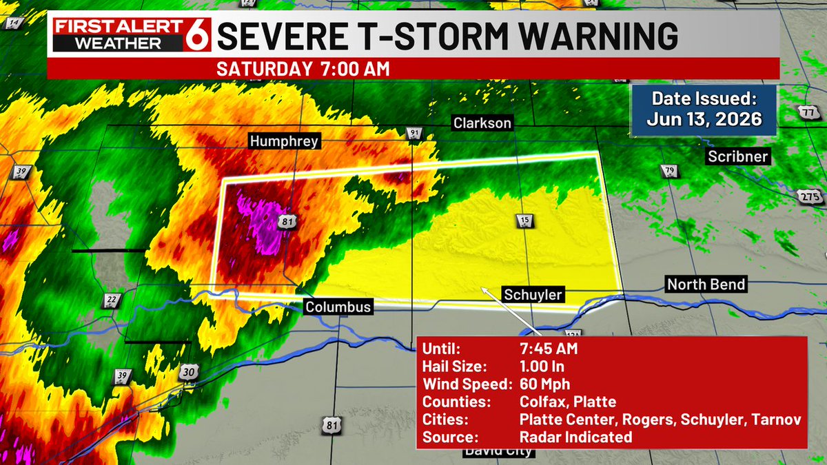
A Severe Thunderstorm Warning is in effect for Colfax, Platte until Jun 13 7:45AM. Large hail and/or damaging winds of at least 60mph are possible. If you are in the warning area, seek shelter immediately.
3
8
2,749
Jun 13
FIRST ALERT: A Severe Thunderstorm Watch is currently in effect for portions of our viewing area until Jun 13 11:00AM. A Severe Thunderstorm Watch means that conditions are favorable for the development of severe storms. Stay tuned for possible warnings.
4
11
2,509
Jun 13
Here's a look at the high temperatures across our area from earlier today.
2
6
1,610
Rusty Lord WOWT retweeted

AND. HERE. WE. GO!
The best 10-11 days on the Omaha calendar start right now. It’s College World Series time!
#MCWS
3
19
2,543
Jun 12
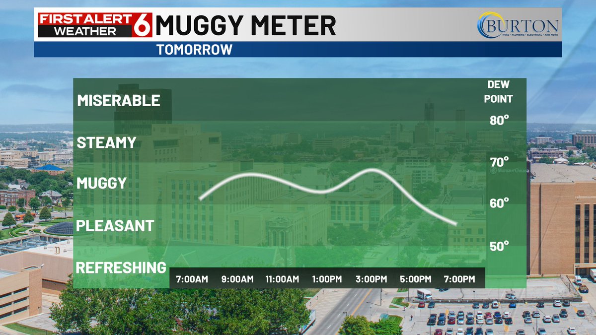
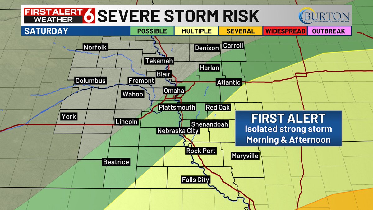
FIRST ALERT to scattered storms possible Saturday morning and again in the evening. Most storms should be pressing south and out of the area by 6pm. Severe potential with any of the storms too. North wind kicks up after the storm threat into the evening. It will be muggier during


1
17
2,925
Jun 12
A cool morning in the 50s will turn into a wonderful afternoon in the 80s. Light wind and low humidity most of the day with abundant sunshine will make it incredibly enjoyable.
3
15
2,702
Jun 12
Here's a look at the high temperatures across our area from earlier today.

2
1
1,685
Rusty Lord WOWT retweeted

Jun 11
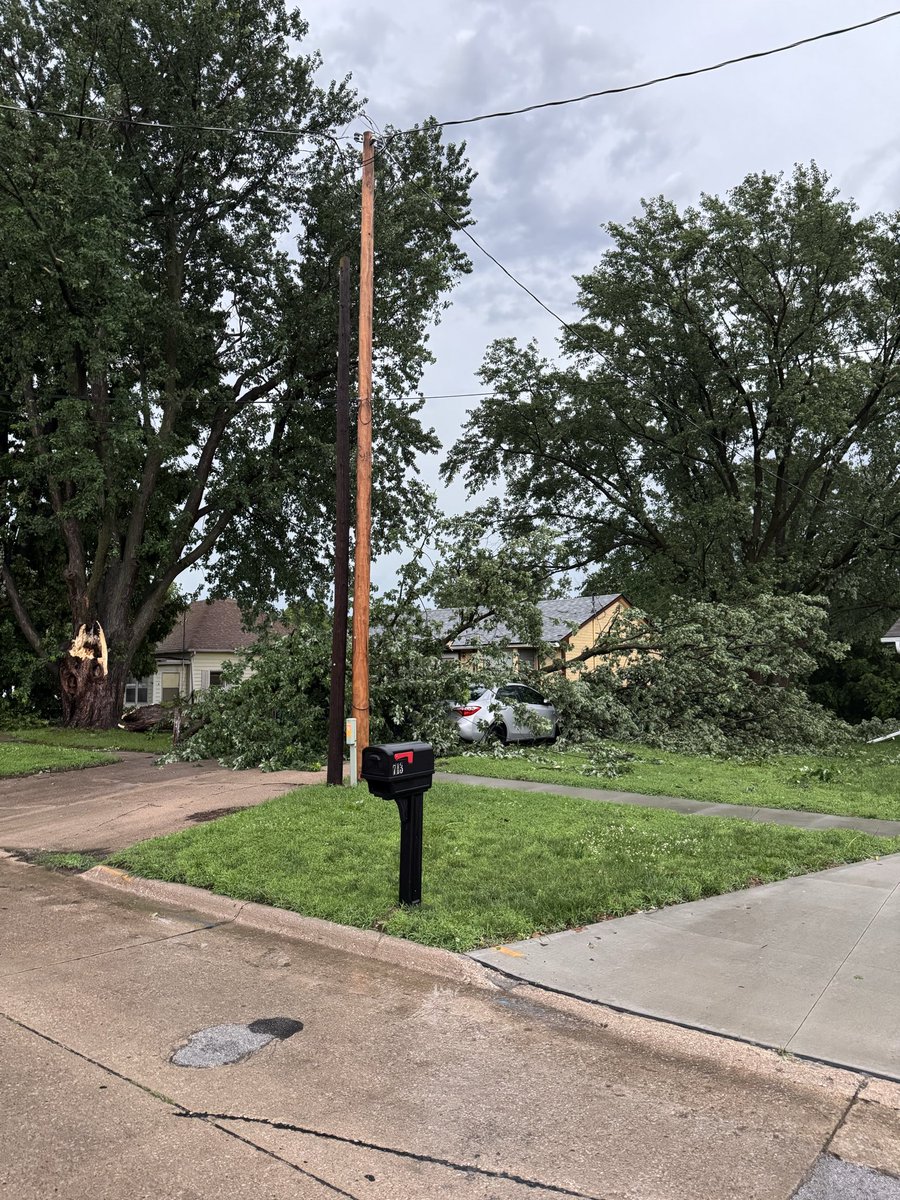
Glenwood Iowa
Store blew down part of a tree that fell on 2 cars @RustyLord

2
13
4,381
Jun 11
A Severe Thunderstorm Warning is in effect for Cass, Otoe, Lancaster, Sarpy until Jun 11 5:45AM. Damaging winds of at least 70mph or hail the size of golf balls or larger is likely!

3
10
2,958