
Accurate, local weather without the mainstream hype! Proudly serving Bedford, Coffee, Franklin, Grundy, Marshall, Maury, and Moore Counties in Southern TN!
Joined October 2016
- Tweets 23,614
- Following 1,102
- Followers 2,328
- Likes 25,988
4,785 Photos and videos

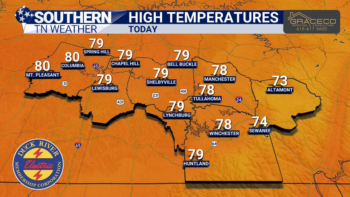


Kirby’s Weather Snapshot — This Monday, June 15th edition is proudly sponsored by GraceCo Roofing. (GraceCoRoofing.com)
4
59
🌤️ WORK WEEK OUTLOOK: DRY PERIODS AND SOME RAIN
NEW BLOG is LIVE!
Proudly presented by Heritage South Community Credit Union — We Help When Others Won't!
After a beautiful start to the week, Southern Middle Tennessee's forecast has a little bit of everything.
☀️ Mostly dry weather sticks around through Wednesday with comfortable temperatures and only a small chance for a stray shower.
⛈️ Our next weather maker arrives Thursday into early Friday, bringing widespread shower and thunderstorm chances. At this point, the severe weather threat appears low, but periods of heavy rain will be possible.
😎 Saturday is currently shaping up to be the pick of the 7-day forecast before rain chances begin increasing again later in the weekend and early next week.
I break down the entire week ahead, including:
• The beautiful weather to start the week
• When rain chances return
• Thursday and Friday's storm potential
• The latest weekend forecast
Read now on the STN Weather App or at stnweather.com/blog/work-wee…
2
64
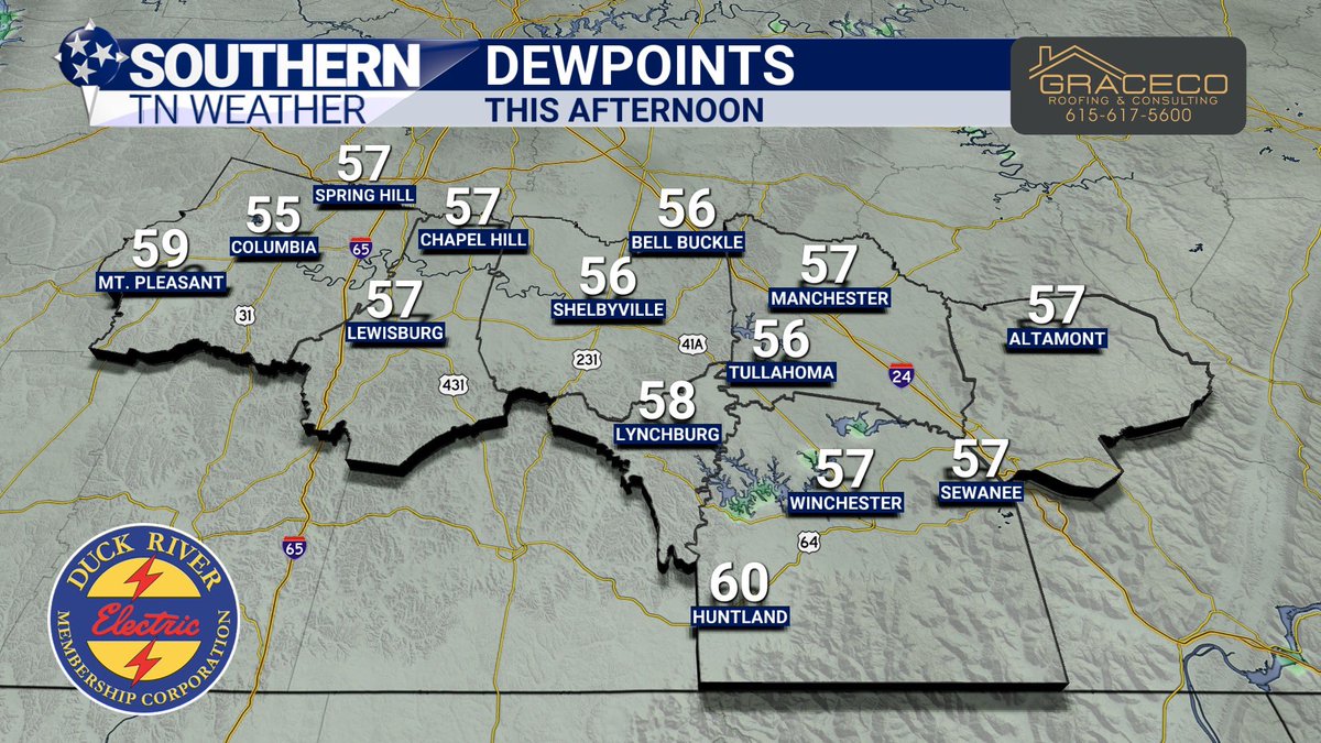
You can actually walk outside without feeling like you’re stuck in a wet sock today! Isn’t that nice?
Highs today will climb into the upper 70s under mostly sunny skies. Dew points will only reach the upper 50s, meaning humidity levels will be MUCH lower than they’ve been the past few days when dew points were in the 70s.
Tonight will be one of the coolest nights we’ve had in quite a while, with lows dropping into the upper 50s. It might be a good excuse to crack open the windows and let some fresh air into the house!
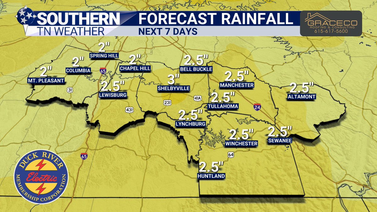
Unfortunately, I’m already tracking our next chance for rain. We should stay dry through Wednesday, but rain chances will increase dramatically by Thursday and Friday. A tropical disturbance lifting north from the Gulf will likely interact with an approaching cold front, bringing a few rounds of showers, thunderstorms, and heavy rainfall to the region.
Right now, rainfall guidance from the Weather Prediction Center suggests much of Southern Middle Tennessee could pick up 2 to 3 inches of rain over the next seven days, with the bulk of that falling Thursday and Friday. A few stronger storms can’t be ruled out either, but we’re still several days away, so I’ll hold off on getting into those details until we get a little closer.
SIDE NOTE: A huge thank you to Christopher for taking the reins on the page yesterday afternoon during the severe weather. I was at Bonnaroo working with festival officials to help keep them updated on the weather moving through. I’m grateful to have Christopher on the team so I can occasionally step away and experience some of the behind-the-scenes operations that help make one of Southern Middle Tennessee’s biggest events a reality!
______________________________
🏠 This forecast update is brought to you by GraceCo Roofing & Consulting — your locally owned Shelbyville roofing experts!
Owned and operated right here in Shelbyville, GraceCo Roofing & Consulting brings more than 14 years of roofing experience and a commitment to honest, no-pressure service. Whether you’re dealing with storm damage, need a roof replacement, or are considering new siding or gutters, their team is ready to help. Serving both homeowners and businesses across Southern Middle Tennessee, every project comes with transparent pricing, quality craftsmanship, and industry-leading warranties.
📍 Shelbyville, TN
📞 615-617-5600
🌐 gracecoroofing.com

4
114
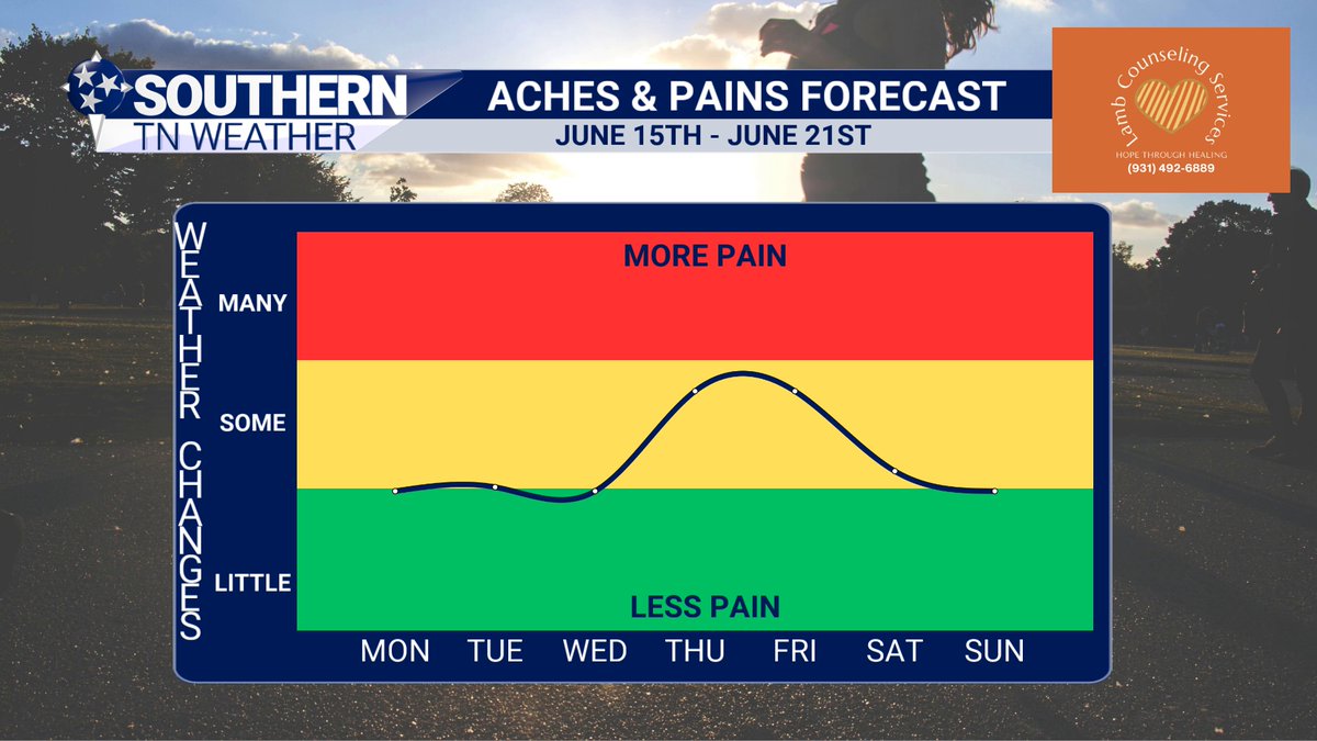
🦴🌦️🌿 ACHES, PAINS & POLLEN FORECAST | June 15th – June 21st
Presented by Lamb Counseling Services
A fairly quiet start to the week is on tap across Southern Middle Tennessee, and that's good news for those who deal with arthritis, joint pain, headaches, and migraines.
With stable weather and relatively small day-to-day changes in temperature and barometric pressure, pain levels should remain in the green or "less pain" category through the first half of the week. By Thursday and Friday, however, we'll likely notice an uptick in discomfort as a tropical moisture plume from the Gulf increases rain chances and leads to falling pressure and more unsettled weather. While this system isn't expected to bring the kind of dramatic weather swings associated with our biggest pain events, it should be enough to push many folks into the moderate or "yellow" category before conditions gradually improve next weekend.
The pollen forecast remains fairly typical for mid-June. Tree pollen has largely run its course, and weed pollen stays low for now, with its peak still a few months away. Grass pollen, however, remains elevated thanks to rapid summer growth, while mold levels continue to run high due to moist soils, warm temperatures, and increasing humidity. Any periods of rainfall may temporarily knock pollen counts down, but they'll also provide a favorable environment for mold spores.
Lamb Counseling Services: Even when the forecast changes, you don't have to face it alone.
📖 "Cast all your anxiety on Him because He cares for you." — 1 Peter 5:7
Hope Through Healing!
🌐 lambcounseling.net/
📞 (931) 492-6889

6
129
☄️FIREBALL OVER LYNCHBURG
Our skycam in Lynchburg caught a fireball streaking through the northwest sky at 10:26 PM. Did you see it?
11
65
248
11,158
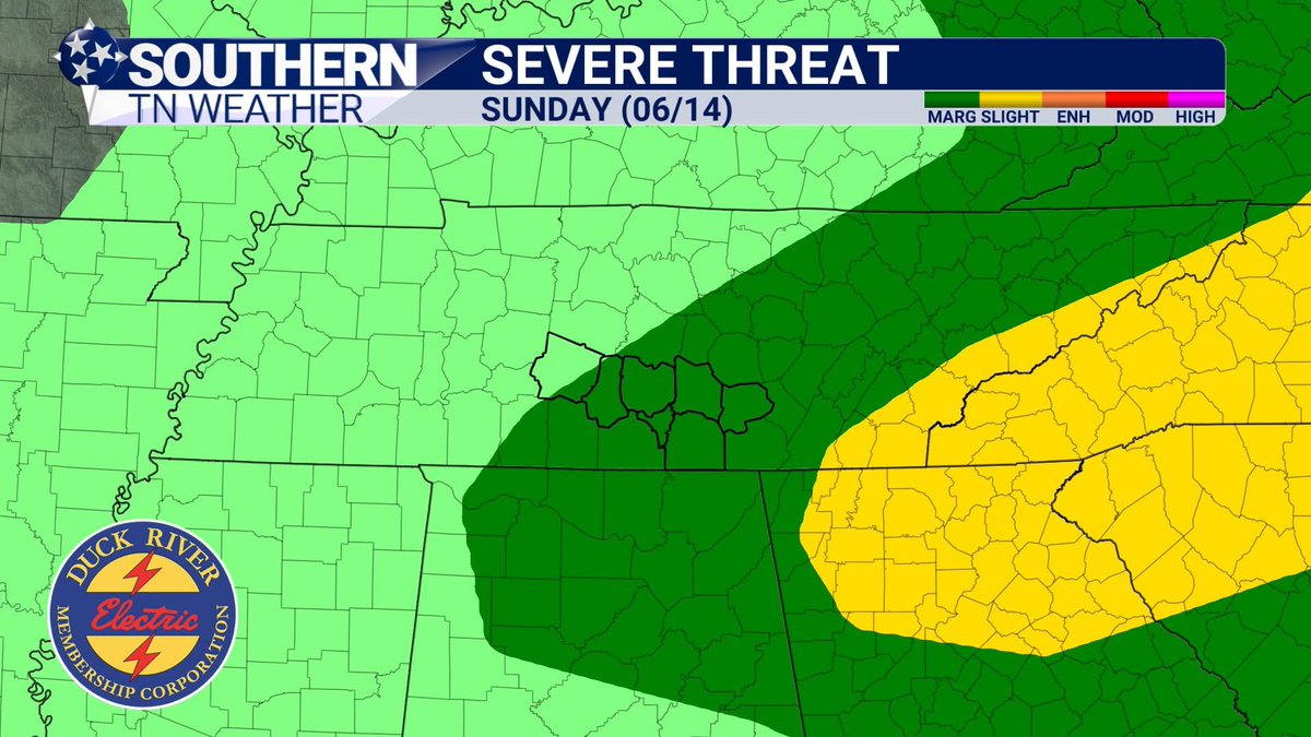
Special Weather Statement for Coffee & Grundy until 4:15 PM 6/14. Wind gusts up to 40 mph possible. Radar indicated. Gusts may knock down tree limbs and blow unsecured objects. If outdoors, seek shelter inside a building.
3
120
Special Weather Statement for Jackson, Moore, Franklin until 4:00 PM 6/14. Wind gusts up to 50 mph. Torrential rain may cause localized flooding. If outdoors, seek shelter inside. Don’t drive through flooded roads.
5
130
Special Weather Statement for Coffee and Grundy until 3:30 PM 6/14. Wind gusts up to 40 mph possible, knocking down tree limbs and blowing around unsecured objects. If outdoors, seek shelter inside a building.
3
103
Flood Advisory for Bedford, Coffee, and Grundy, TN until 6:00 PM CDT. Flooding from heavy rain is expected with minor flooding/ponding in low-lying areas. Turn around, don’t drown—avoid flooded roads and don’t drive through water.
5
95
[Weather Alert] Severe Thunderstorm Warning for Franklin, Lincoln, and Moore County until 3:30pm CDT.
3
77
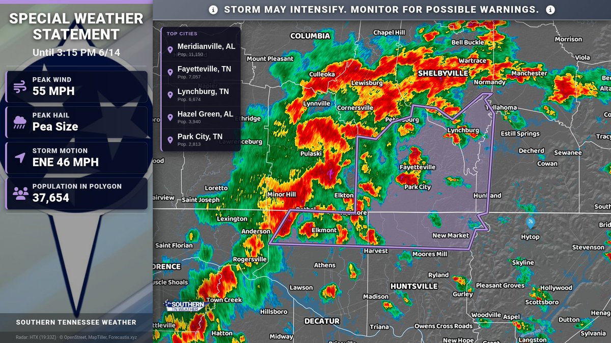
Special Weather Statement for Limestone, Madison, Moore, Lincoln, Franklin until 3:15 PM 6/14. Wind gusts 50-55 mph possible. Gusty winds may knock down tree limbs and blow unsecured objects. If outdoors, seek shelter inside a building.
4
147
Flood Advisory for Bedford, Giles, and Marshall, TN until 5:45 PM CDT. Urban and small stream flooding expected from excessive rain. Minor flooding/overflowing poor drainage areas possible. Turn around, don’t drown—avoid flooded roads.
6
109
Special Weather Statement for Wilson, Williamson, Rutherford, Cannon, De Kalb, Bedford until 3:00 PM 6/14. Wind gusts up to 50 mph may knock down tree limbs and blow unsecured objects. If outdoors, seek shelter inside.
6
75
[Weather Alert] Severe Thunderstorm Warning for Marshall County until 3:00pm CDT.
5
72
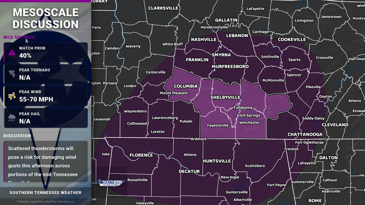
Mesoscale Discussion — Portions of the mid-Tennessee River Valley. Scattered thunderstorms this afternoon may produce damaging wind gusts.
3
81
JUST IN: The Storm Prediction Center has introduced a SLIGHT risk (level 2/5) for severe thunderstorms this afternoon and evening for a good portion of our area outside of far western zones.
The forecast for today remains on track. Scattered showers and storms this afternoon and evening will be capable of producing damaging wind gusts up to 60 MPH, frequent lightning, and heavy rainfall.
Main timeframe is noon through 8 PM. STAY TUNED for additional information!
4
97
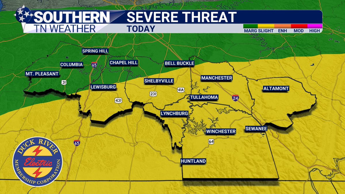
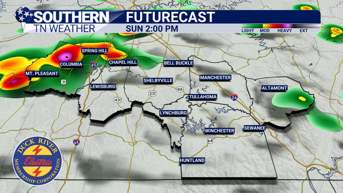
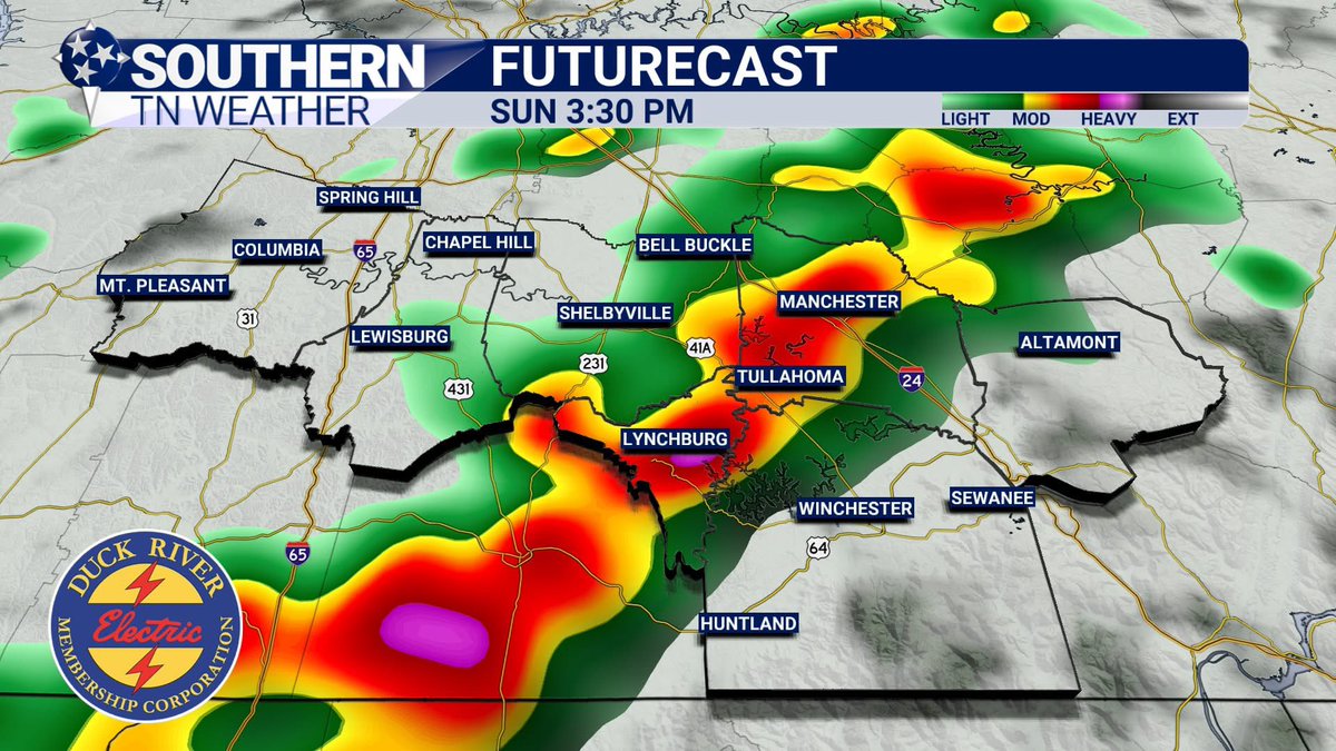
🟩 LOW-END RISK OF SEVERE WEATHER THIS AFTERNOON
The Storm Prediction Center (SPC) has place most of the Southern Tennessee Weather coverage area under a Marginal Risk (1/5) for severe weather today.
As the case with many of these summertime weather patterns, you can expect gusty winds, heavy rain, and lightning like we have seen over the past few days. In this case, there is a low-end possibility that a couple of these storms could reach severe limits. Again, damaging winds would be the main threat with any of these storms.
I've attached a couple of images of Futurecast so that you can have a timeframe in mind if you going to be out and about this afternoon, especially if you're headed out to the Farm for the last day of Bonnaroo.
Elijah and I will have all the latest as these storms approach. For now, just be weather-aware this afternoon. Stay tuned!
- Support Meteorologist Christopher King
5
168
lol this is a great question. And honestly, I don’t have a good scientific answer. Other than it just seems like the better storm ingredients are USUALLY west of I-65.

1
2
472
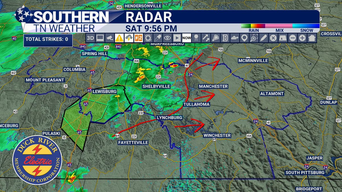
Well... these storms fizzled out quicker than a New Year's resolution at the dessert table. The Bedford Bubble actually works on something besides snow! Who knew?
All jokes aside, a little light to moderate, inconsequential rain remains for some moving eastbound, but our storm threat is winding down for the evening. This will likely be my last social media update of the night unless something unexpected develops.
Don't put the umbrella away just yet, though. Scattered showers and thunderstorms are back in the forecast for tomorrow, especially during the afternoon and evening hours. As always, I'll be keeping an eye on things and will have updates if needed. Have a great evening, y'all!
3
142